C/S TX Weather: Seasonal with some rains

U.S. & Caribbean Weather Discussions and Severe Weather Events

Moderator: S2k Moderators

Forum rules

The posts in this forum are NOT official forecast and should not be used as such. They are just the opinion of the poster and may or may not be backed by sound meteorological data. They are NOT endorsed by any professional institution or STORM2K.

Help Support Storm2K
Message
Author
User avatar
Ptarmigan
Category 5
Category 5
Posts: 5313
Joined: Wed Aug 16, 2006 9:06 pm

Re: C/SC TX Weather: Frying Pan Summer

#601 Postby Ptarmigan » Sat Jun 18, 2011 8:31 pm

Shoshana wrote:Thank you!!

Highs today: Mabry 106 Bergstrom 105

Beffore we left the house earlier our gauge was reading 109. Again.

RAID! RAID! RAID! Where's the Raid! Meanwhile everyone get out your roach stompers! (aka those pointy toe cowboy boots!)


Need to start squishing them Cockroach Ridge to give us rain! :grrr: :lol:
0 likes   

User avatar
Rgv20
S2K Supporter
S2K Supporter
Posts: 2466
Age: 38
Joined: Wed Jan 05, 2011 5:42 pm
Location: Edinburg/McAllen Tx

#602 Postby Rgv20 » Sat Jun 18, 2011 10:13 pm

Looks like the first surge of Tropical Moisture is still on schedule to arrive on Wednesday :D

0zNam
Image
0 likes   
The following post is NOT an official forecast and should not be used as such. It is just the opinion of the poster and may or may not be backed by sound meteorological data. It is NOT endorsed by any professional institution including storm2k.org For Official Information please refer to the NHC and NWS products.

User avatar
horselattitudesfarm
Category 1
Category 1
Posts: 315
Joined: Thu Jul 16, 2009 5:55 pm
Location: Asheville, NC (formerly from Dallas, TX)

Re: C/SC TX Weather: Frying Pan Summer

#603 Postby horselattitudesfarm » Sun Jun 19, 2011 7:57 am

Unfortunately for South Texas (San Antonio area) the latest NOAA forecast discussion has this to say:

MODEL TRENDS CONTINUE TO BE UNKIND ON PRECIPATION POTENTIAL FOR
WEDNESDAY INTO NEXT WEEKEND...COMPARED TO THE MORE UNSTABLE
SCENARIOS THAT WERE SUGGESTED A FEW DAYS AGO. A DECENT SHOT OF
RAIN IS STILL DEPICTED FOR TUESDAY NIGHT THROUGH WEDNESDAY
NIGHT...BUT THE LEVEL OF UNCERTAINTY REMAINS HIGH DESPITE THE
EVENT GETTING CLOSER IN TIME. A COUPLE OF FEATURES TO THE SOUTH
ARE CONTRIBUTING TO THE UNCERTAINTY...INCLUDING A BREAK IN THE
TROPICAL PLUME TAP FROM THE PACIFIC AND A WEAK TROPICAL WAVE NEAR
BELIZE. WHILE EARLIER MODEL RUNS SUGGESTED BETTER TROPICAL
MOISTURE INPUT INTO THE RIDGE WHEN THE UPPER TROUGH REACHES TX ON
WEDNESDAY...THE MORE RECENT MODEL DATA LIMITS THE AMOUNT OF
MOISTURE. THE GFS HAS TRENDED MUCH STRONGER WITH THE REBUILDING OF
THE UPPER RIDGE AFTER THE TROUGH DEPARTS THURSDAY. SINCE THE ECMWF
ALSO SHOWS A SIMILAR BUT SLIGHTLY MORE SUBTLE TREND...WILL OPT FOR
A MORE BEARISH FORECAST AND NUDGE HIGH TEMPS BACK TO ABOVE
GUIDANCES AND CLIMATOLOGY IN THE EXTENDED FORECAST.
0 likes   

User avatar
Rgv20
S2K Supporter
S2K Supporter
Posts: 2466
Age: 38
Joined: Wed Jan 05, 2011 5:42 pm
Location: Edinburg/McAllen Tx

#604 Postby Rgv20 » Sun Jun 19, 2011 11:09 am

Brownsville morning discussion.

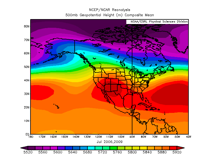
LONG TERM /MONDAY NIGHT THROUGH SATURDAY/...A MAJOR MID LEVEL
TROUGH WILL DIG DEEP ACROSS THE CENTRAL PORTION OF THE LOWER 48
STATES EARLY NEXT WEEK WHICH WILL IN TURN ERODE AWAY THE RIDGE
WHICH HAS PERSISTED OVER THE SOUTH CENTRAL PLAINS STATES AND
NORTHERN MEXICO. THIS OVERALL WEAKNESS IN THE MID LEVEL RIDGING
WILL PERSIST THROUGHOUT THE REST OF THE UPCOMING WEEK. AS THE
CENTRAL U.S. TROUGH PUSHES FURTHER EAST LATE IN THE WEEK THE
RIDGING WILL BUILD BACK INTO THE REGION BRINGING IN A MORE
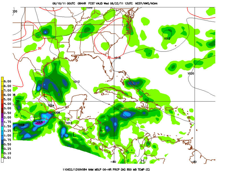
SUBSIDENT AIRMASS BACK IN PLACE. DEEP TROPICAL MOISTURE WILL BE
ADVECTING NORTH AND NORTHWEST OVER THE TX COASTLINE FROM A
WESTWARD MOVING TROPICAL WAVE NOW LOCATED OVER THE YUCATAN
PENINSULA. THIS COMBINATION OF THE BROAD MID LEVEL TROFFING AND
THE REBOUNDING TROPICAL MOISTURE WILL INCREASE THE OVERALL POPS
FOR ISOLD TO SCT CONV DURING MOST OF THE EXTENDED RANGE FORECAST
PERIOD GIVING DEEP SOUTH TX SOME SHORT TERM RELIEF TO THE CURRENT
DROUGHT CONDITIONS. THE WEAKENING OF THE CURRENT RIDGING IN PLACE
OVER THE REGION AND THE INCREASING MOISTURE VALUES WILL INCREASE
OVERALL CLD COVER WHICH WILL IN TURN TEND TO LOWER THE OVERALL
TEMPS AND HEAT INDICES A LITTLE IN THE 3 TO 7 DAY RANGE. BOTH THE
GFS AND THE ECMWF SHOW THE BEST AGREEMENT CONCERNING THE 500 MB
FIELDS THROUGH DAY 7. HOWEVER BIGGER DISAGREEMENTS SHOWS UP
BETWEEN THE TWO LONG TERM MODELS CONCERNING THE PLACEMENT OF THE
DEEPER TROPICAL MOISTURE FIELDS. THE ECMWF SHOWS MORE OF A
WESTWARD PLACEMENT OF THE TROPICAL MOISTURE WHILE THE GFS KEEPS
THE MOISTURE POOLED MORE OFFSHORE OVER THE GULF WATERS. THIS
DIFFERENCE IS RESULTING IN A LITTLE DRIER FORECAST FROM THE MOST
RECENT RUN OF THE GFS VERSUS THE LAST SEVERAL DAYS. BELIEVE THAT
THE DRIER GFS RUN MAY BE AN TEMP OUTLIER AND THAT THE NEXT SEVERAL
RUNS WILL LIKELY SHOW MORE AGREEMENT WITH THE ECMWF.
FOR TEMPS THE
GFS MEX GUIDANCE SHOWS PRETTY GOOD RUN TO RUN AGREEMENT AND WILL
STICK PRETTY CLOSE TO THE MEX MAXES AND MINS.


NWS in Brownsville not ready to jump on the dry scenario for now.
0 likes   
The following post is NOT an official forecast and should not be used as such. It is just the opinion of the poster and may or may not be backed by sound meteorological data. It is NOT endorsed by any professional institution including storm2k.org For Official Information please refer to the NHC and NWS products.

Shoshana
Category 5
Category 5
Posts: 1414
Joined: Thu Sep 09, 2004 7:50 pm
Location: NE Austin

#605 Postby Shoshana » Sun Jun 19, 2011 5:29 pm

Day 15 with both a Heat advisory and Red flag warning going on.

I didn't look at our thermometer today - I was outside cooling off with the garden hose (pouring water on my head) while the dog was playing in her doggie pool. I almost joined her.

Highs were 103 @ KAUS and 104 @ KATT

E. Tx wildfire spreads to 14,000 acres

National Forest Service spokeswoman Rae Brooks says the fire started after noon Friday in the Davy Crockett National Forest west of Lufkin. She said Sunday morning it had only been 20 percent contained.

Brooks says the fire is being called the "Bearing Fire" and is one of the largest wildfires ever in East Texas.
0 likes   

User avatar
~FlipFlopGirl~
Tropical Depression
Tropical Depression
Posts: 52
Age: 46
Joined: Sat Jul 24, 2010 7:43 pm
Location: Waco,TX

Re: C/SC TX Weather: Frying Pan Summer

#606 Postby ~FlipFlopGirl~ » Sun Jun 19, 2011 6:10 pm

Waco is at 104 today-another record breaking day!
0 likes   

User avatar
Rgv20
S2K Supporter
S2K Supporter
Posts: 2466
Age: 38
Joined: Wed Jan 05, 2011 5:42 pm
Location: Edinburg/McAllen Tx

#607 Postby Rgv20 » Sun Jun 19, 2011 7:58 pm

Taking a look at the 500mb heights on the GFS and beyond to mid July on the monthly Euro forecast it looks like more dry and hot weather coming up for the first two week of July. :(

This 500mb pattern is almost identical to what the Euro is forecasting. Its a blend of July 2006 and 2009.

Image


Anyway Im just hoping for some beneficial rainfall this up coming week! :D
0 likes   
The following post is NOT an official forecast and should not be used as such. It is just the opinion of the poster and may or may not be backed by sound meteorological data. It is NOT endorsed by any professional institution including storm2k.org For Official Information please refer to the NHC and NWS products.

User avatar
Rgv20
S2K Supporter
S2K Supporter
Posts: 2466
Age: 38
Joined: Wed Jan 05, 2011 5:42 pm
Location: Edinburg/McAllen Tx

#608 Postby Rgv20 » Mon Jun 20, 2011 12:05 am

Come on GFS dont be shy with the Rain. :lol:

Total Rainfall until 7pm Friday.
Image
0 likes   
The following post is NOT an official forecast and should not be used as such. It is just the opinion of the poster and may or may not be backed by sound meteorological data. It is NOT endorsed by any professional institution including storm2k.org For Official Information please refer to the NHC and NWS products.

Shoshana
Category 5
Category 5
Posts: 1414
Joined: Thu Sep 09, 2004 7:50 pm
Location: NE Austin

#609 Postby Shoshana » Mon Jun 20, 2011 3:56 pm

99 at both recording locations. Just waiting for that 100F.
0 likes   

User avatar
Portastorm
Storm2k Moderator
Storm2k Moderator
Posts: 9914
Age: 63
Joined: Fri Jul 11, 2003 9:16 am
Location: Round Rock, TX
Contact:

Re:

#610 Postby Portastorm » Mon Jun 20, 2011 3:59 pm

Shoshana wrote:99 at both recording locations. Just waiting for that 100F.


What we lost in heat today, we have gained in humidity! Notice those dew points?

Edit update: Looks like we hit 100 at Camp Mabry (ATT) at 4 p.m.; 99 at Bergstrom (AUS).
0 likes   
Any forecasts under my name are to be taken with a grain of salt. Get your best forecasts from the National Weather Service and National Hurricane Center.

Shoshana
Category 5
Category 5
Posts: 1414
Joined: Thu Sep 09, 2004 7:50 pm
Location: NE Austin

#611 Postby Shoshana » Mon Jun 20, 2011 4:34 pm

Day 16 them with Mabry's 100.

Yeah I was outside with the pup earlier and it's pretty humid. Blech.

Sure hope we get more than .10" this week.

I read that it's supposed to get hot again (100) after the rain goes away. Lovely.
0 likes   

User avatar
Rgv20
S2K Supporter
S2K Supporter
Posts: 2466
Age: 38
Joined: Wed Jan 05, 2011 5:42 pm
Location: Edinburg/McAllen Tx

#612 Postby Rgv20 » Mon Jun 20, 2011 10:33 pm

It hit 102 at my house but it was definitely more humid today than days past.
0 likes   
The following post is NOT an official forecast and should not be used as such. It is just the opinion of the poster and may or may not be backed by sound meteorological data. It is NOT endorsed by any professional institution including storm2k.org For Official Information please refer to the NHC and NWS products.

User avatar
Portastorm
Storm2k Moderator
Storm2k Moderator
Posts: 9914
Age: 63
Joined: Fri Jul 11, 2003 9:16 am
Location: Round Rock, TX
Contact:

Re: C/SC TX Weather: Frying Pan Summer

#613 Postby Portastorm » Tue Jun 21, 2011 8:47 am

I noticed some clear liquid appearing on my car windshield this morning driving into work. Not much, mind you ... but it was strange. The elders tell me it is called "rain."
0 likes   
Any forecasts under my name are to be taken with a grain of salt. Get your best forecasts from the National Weather Service and National Hurricane Center.

User avatar
Tireman4
S2K Supporter
S2K Supporter
Posts: 5853
Age: 59
Joined: Fri Jun 30, 2006 1:08 pm
Location: Humble, Texas
Contact:

Re: C/SC TX Weather: Frying Pan Summer

#614 Postby Tireman4 » Tue Jun 21, 2011 8:54 am

Portastorm wrote:I noticed some clear liquid appearing on my car windshield this morning driving into work. Not much, mind you ... but it was strange. The elders tell me it is called "rain."


I called the Portastorm Weather Center this morning. Someone answered and then in the background, "I heard...Hey...is that...what is that falling from the sky...oh wait, pass the Grey Goose". What in the wild wild world of sports is a goin on over there?
0 likes   

User avatar
Portastorm
Storm2k Moderator
Storm2k Moderator
Posts: 9914
Age: 63
Joined: Fri Jul 11, 2003 9:16 am
Location: Round Rock, TX
Contact:

Re: C/SC TX Weather: Frying Pan Summer

#615 Postby Portastorm » Tue Jun 21, 2011 9:00 am

I'm not even sure if the Portastorm Weather Center meteorologists can spell "rain" let alone forecast it! :lol:

Hey, we hope everyone in Texas has a chance to lift a glass of Grey Goose in the next few days and salute rain falling.
0 likes   
Any forecasts under my name are to be taken with a grain of salt. Get your best forecasts from the National Weather Service and National Hurricane Center.

User avatar
gboudx
S2K Supporter
S2K Supporter
Posts: 4080
Joined: Thu Sep 04, 2003 1:39 pm
Location: Rockwall, Tx but from Harvey, La

#616 Postby gboudx » Tue Jun 21, 2011 9:16 am

We got quite a bit of rain last night here on the east side of the Metroplex. Was nice to be awakened in the middle of the night to thunder, lightning and pouring rain. Radar estimates 2"+ for my area. Ground is soaked and temps were in the 60's this morning. It also smelled like smoke. Hope you guys down south get in on the rain.
0 likes   

Shoshana
Category 5
Category 5
Posts: 1414
Joined: Thu Sep 09, 2004 7:50 pm
Location: NE Austin

#617 Postby Shoshana » Tue Jun 21, 2011 12:42 pm

Nothing so far in the wilds of far North Austin/ P'ville.

I am dogsitting and it seems to rain every time I do so. (and lightning and thunder too) So here's hoping we have rain! Because yes, I do want 5 wet dogs tracking mud in thru the doggie door! lol

I hate this sticky humidity! Rain already!
0 likes   

User avatar
~FlipFlopGirl~
Tropical Depression
Tropical Depression
Posts: 52
Age: 46
Joined: Sat Jul 24, 2010 7:43 pm
Location: Waco,TX

#618 Postby ~FlipFlopGirl~ » Tue Jun 21, 2011 4:10 pm

Still waiting on the rain in Waco- The humidity is horrible- the overcast is nice but I may be force to water the lawn after all
0 likes   

Shoshana
Category 5
Category 5
Posts: 1414
Joined: Thu Sep 09, 2004 7:50 pm
Location: NE Austin

#619 Postby Shoshana » Tue Jun 21, 2011 4:58 pm

Day 17 Mabry 101 Bergstrom 100 so far

The heat + humidity is exhausting. Guess we still have tonight and tomorrow to possibly get rain - after that it looks like 0 till who knows when since July is usually a really dry month normally.
0 likes   

User avatar
Rgv20
S2K Supporter
S2K Supporter
Posts: 2466
Age: 38
Joined: Wed Jan 05, 2011 5:42 pm
Location: Edinburg/McAllen Tx

#620 Postby Rgv20 » Tue Jun 21, 2011 6:44 pm

No 100 for my house!! It was 99 its still feels the same haha.

I saw fluffy white stuff in the sky anybody know what they are?? Guess somebody must have had a huge pillow fight... lol
0 likes   
The following post is NOT an official forecast and should not be used as such. It is just the opinion of the poster and may or may not be backed by sound meteorological data. It is NOT endorsed by any professional institution including storm2k.org For Official Information please refer to the NHC and NWS products.


Return to “USA & Caribbean Weather”

Who is online

Users browsing this forum: No registered users and 23 guests