Global model runs discussion
Moderator: S2k Moderators
Re: Global Model Runs Discussion
I can always dream there, Mike  but seriously I see nothing out there now that would seem worthy of that development. The local met even brought this action up on the News last night as we are all hoping for a break in this drought.
0 likes
-
Ivanhater

- Storm2k Moderator

- Posts: 11221
- Age: 39
- Joined: Fri Jul 01, 2005 8:25 am
- Location: Pensacola
Re: Global Model Runs Discussion
Here we go again...12z GFS showing a 1003mb system and very heavy rain spreading along the entire Gulf coast
[img]
Uploaded with ImageShack.us[/img]
[img]
Uploaded with ImageShack.us[/img]
[img]

Uploaded with ImageShack.us[/img]
[img]

Uploaded with ImageShack.us[/img]
0 likes
Michael

Re: Global Model Runs Discussion
I sure hope that forecast comes true, we are parched!
0 likes
The following post is NOT an official forecast and should not be used as such. It is just the opinion of the poster and may or may not be backed by sound meteorological data. It is NOT endorsed by any professional institution including storm2k.org For Official Information please refer to the NHC and NWS products.
-
CYCLONE MIKE
- Category 5

- Posts: 2183
- Joined: Tue Aug 31, 2004 6:04 pm
- Location: Gonzales, LA
Re: Global Model Runs Discussion
Its all well and good at what the gfs is showing. Sure hoping it comes to fruition but not holding my breath, especially after the terrible performance it had last year. These models are about as accurate as my cities 7 day forecast. So hears hoping for some good tropical rains and the models can show it every day as they wish, but wont believe it until I actually see some kind of disturbance in the gulf.
0 likes
-
Rgv20

- S2K Supporter

- Posts: 2466
- Age: 39
- Joined: Wed Jan 05, 2011 5:42 pm
- Location: Edinburg/McAllen Tx
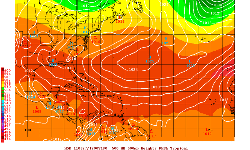
Here we go 12zECMWF showing development in the BOC around Tuesday 06/28 a little later than the GFS.
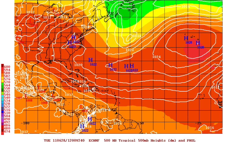
This map shows a lowering of 500mb heights in the BOC by day 10.
This map shows a lowering of 500mb heights in the BOC by day 10.
0 likes
The following post is NOT an official forecast and should not be used as such. It is just the opinion of the poster and may or may not be backed by sound meteorological data. It is NOT endorsed by any professional institution including storm2k.org For Official Information please refer to the NHC and NWS products.
-
Dean4Storms
- S2K Supporter
- Posts: 6358
- Age: 63
- Joined: Sun Aug 31, 2003 1:01 pm
- Location: Miramar Bch. FL
-
Rgv20
- S2K Supporter
- Posts: 2466
- Age: 39
- Joined: Wed Jan 05, 2011 5:42 pm
- Location: Edinburg/McAllen Tx
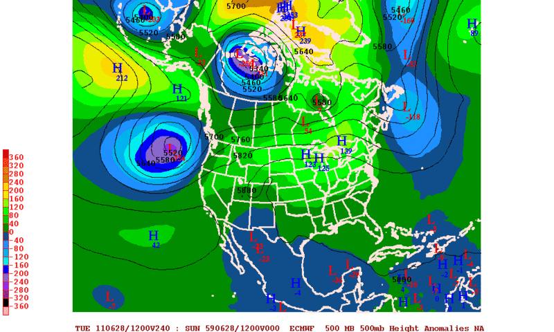
0zGFS and Nogaps agree on a broad low around the yucatan in the 180hr mark that would put it on Monday 06/27.
0zNogaps
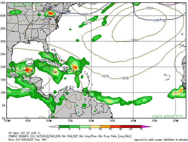
0zGFS
0zNogaps
0zGFS
0 likes
The following post is NOT an official forecast and should not be used as such. It is just the opinion of the poster and may or may not be backed by sound meteorological data. It is NOT endorsed by any professional institution including storm2k.org For Official Information please refer to the NHC and NWS products.
-
cycloneye

- Admin

- Posts: 149508
- Age: 69
- Joined: Thu Oct 10, 2002 10:54 am
- Location: San Juan, Puerto Rico
Re: Global Model Runs Discussion
This is super long range and we know the drill,but is the first time this season that the long range GFS has a interesting feature in the MDR by July 7. Now,let's see if the model drops it quickly,or it stays with it and later,other models join.

0 likes
Visit the Caribbean-Central America Weather Thread where you can find at first post web cams,radars
and observations from Caribbean basin members Click Here
and observations from Caribbean basin members Click Here

Re: Global Model Runs Discussion
00Z CMC was showing a deep warm core spinning up off GA coast and tracking along the Gulf Stream the July 4 weekend.
Now, 12Z GFS has jumped on board.
http://mag.ncep.noaa.gov/NCOMAGWEB/appcontroller?prevpage=Param&MainPage=index&image=&page=Param&cycle=06%2F27%2F2011+12UTC&rname=UPPER+AIR+PARMS&pname=850_vort_ht&model=GFS&area=ATLANTIC&cat=MODEL+GUIDANCE&areaDesc=Atlantic+region&fcast=Loop+All

Now, 12Z GFS has jumped on board.
http://mag.ncep.noaa.gov/NCOMAGWEB/appcontroller?prevpage=Param&MainPage=index&image=&page=Param&cycle=06%2F27%2F2011+12UTC&rname=UPPER+AIR+PARMS&pname=850_vort_ht&model=GFS&area=ATLANTIC&cat=MODEL+GUIDANCE&areaDesc=Atlantic+region&fcast=Loop+All
0 likes
-
floridasun78
- Category 5
- Posts: 3755
- Joined: Sun May 17, 2009 10:16 pm
- Location: miami fl
 that area north PR grow from this morning
-
cycloneye
- Admin
- Posts: 149508
- Age: 69
- Joined: Thu Oct 10, 2002 10:54 am
- Location: San Juan, Puerto Rico
Re: Global Model Runs Discussion
0 likes
Visit the Caribbean-Central America Weather Thread where you can find at first post web cams,radars
and observations from Caribbean basin members Click Here
and observations from Caribbean basin members Click Here
-
floridasun78
- Category 5
- Posts: 3755
- Joined: Sun May 17, 2009 10:16 pm
- Location: miami fl

Re: Global Model Runs Discussion
floridasun78 wrote:we may not see A storm untill late july
I know you meant late June.
0 likes
The following post is NOT an official forecast and should not be used as such. It is just the opinion of the poster and may or may not be backed by sound meteorological data. It is NOT endorsed by any professional institution including storm2k.org For Official Information please refer to the NHC and NWS products.
Re: Global Model Runs Discussion
GFS has been showing a somewhat consistent storm hitting s/middle texas around 240 hours.
0 likes
-
SETXWXLADY
- Tropical Storm

- Posts: 216
- Joined: Wed May 20, 2009 3:26 pm
- Location: SE TX Orange County
Re: Global Model Runs Discussion
lebron23 wrote:GFS has been showing a somewhat consistent storm hitting s/middle texas around 240 hours.
ECMWF second night of showing a low. Takes into TX/LA around same time.

0 likes

Tropical wave approaching 50W will have to watched, this the tropical wave that both the GFS & ECMWF have been showing development in their past few runs for next week as it gets in the western Caribbean/southern GOM.
GFS ensembles have been wanting to weaken the southern ridge for next week, so any tropical development by then in the western Caribbean will have to be watched.

GFS ensembles have been wanting to weaken the southern ridge for next week, so any tropical development by then in the western Caribbean will have to be watched.
0 likes
Re: Global Model Runs Discussion
FIM is latching onto a potent wave entering the West GOM around July 7th.
Shows it developing and making a track toward the Houston area.

Shows it developing and making a track toward the Houston area.
0 likes
Who is online
Users browsing this forum: No registered users and 42 guests