WPAC: MA-ON - Remnants

Moderator: S2k Moderators

Message
Author
dwsqos2

Re: WPAC: MA-ON - Severe Tropical Storm

#181 Postby dwsqos2 » Wed Jul 13, 2011 9:58 am

euro6208 wrote:Truly underestimated Ma-On continues to strengthen. I would place the intensity at 90 knots 1 minute winds based on it's overall organization and well formed eye which it had for nearly 24 hours.


No agencies' satellite intensity estimates suggest an intensity this high; even the ADT values aren't that high.
0 likes   

euro6208

Re: WPAC: MA-ON - Severe Tropical Storm

#182 Postby euro6208 » Wed Jul 13, 2011 10:11 am

dwsqos2 wrote:
euro6208 wrote:Truly underestimated Ma-On continues to strengthen. I would place the intensity at 90 knots 1 minute winds based on it's overall organization and well formed eye which it had for nearly 24 hours.


No agencies' satellite intensity estimates suggest an intensity this high; even the ADT values aren't that high.


those are just estimates. this is a big deal stronger than 65 knots

CI# /Pressure/ Vmax
5.2 / 956.9mb/ 94.8kt
0 likes   

dwsqos2

Re: WPAC: MA-ON - Severe Tropical Storm

#183 Postby dwsqos2 » Wed Jul 13, 2011 10:14 am

I hadn't looked at the latest ADT values which actually are near 90 knots. But, ADT tends to have a bit of a high bias.
0 likes   

euro6208

Re: WPAC: MA-ON - Severe Tropical Storm

#184 Postby euro6208 » Wed Jul 13, 2011 10:21 am

Image

goodness gracious. is that a category 4 or 5 landfall? looking very scary
0 likes   

euro6208

Re: WPAC: MA-ON - Severe Tropical Storm

#185 Postby euro6208 » Wed Jul 13, 2011 10:26 am

euro has ma-on to continue to move west for the next 3 days. looks like more heavy rains for guam and our northern neighbors.
0 likes   

User avatar
srainhoutx
S2K Supporter
S2K Supporter
Posts: 6919
Age: 67
Joined: Sun Jan 14, 2007 11:34 am
Location: Haywood County, NC
Contact:

Re: WPAC: MA-ON - Severe Tropical Storm

#186 Postby srainhoutx » Wed Jul 13, 2011 10:42 am

euro6208 wrote:
dwsqos2 wrote:
euro6208 wrote:Truly underestimated Ma-On continues to strengthen. I would place the intensity at 90 knots 1 minute winds based on it's overall organization and well formed eye which it had for nearly 24 hours.


No agencies' satellite intensity estimates suggest an intensity this high; even the ADT values aren't that high.


those are just estimates. this is a big deal stronger than 65 knots

CI# /Pressure/ Vmax
5.2 / 956.9mb/ 94.8kt


NOAA estimates are a bit weaker. I'd be cautious with those ADT estimates as they tend to be a bit too generous...

13/1432 UTC 20.1N 149.3E T4.5/4.5 MA-ON -- West Pacific
0 likes   
Carla/Alicia/Jerry(In The Eye)/Michelle/Charley/Ivan/Dennis/Katrina/Rita/Wilma/Ike/Harvey

Member: National Weather Association
Wx Infinity Forums
http://wxinfinity.com/index.php

Facebook.com/WeatherInfinity
Twitter @WeatherInfinity

User avatar
x-y-no
Category 5
Category 5
Posts: 8359
Age: 65
Joined: Wed Aug 11, 2004 12:14 pm
Location: Fort Lauderdale, FL

Re: WPAC: MA-ON - Severe Tropical Storm

#187 Postby x-y-no » Wed Jul 13, 2011 10:54 am

euro6208 wrote:goodness gracious. is that a category 4 or 5 landfall? looking very scary


969mb ... a significant storm alright, but not cat 4 or 5.
0 likes   

User avatar
Rgv20
S2K Supporter
S2K Supporter
Posts: 2466
Age: 38
Joined: Wed Jan 05, 2011 5:42 pm
Location: Edinburg/McAllen Tx

Re: WPAC: MA-ON - Severe Tropical Storm

#188 Postby Rgv20 » Wed Jul 13, 2011 12:11 pm

x-y-no wrote:
euro6208 wrote:goodness gracious. is that a category 4 or 5 landfall? looking very scary


969mb ... a significant storm alright, but not cat 4 or 5.


On the closeup of Japan on Accuweather pro, 0zECMWF it looks like the sea level pressure is at least sub 940 by Monday 12z. Its really hard to tell because the isobars are so tightly packed :eek:
0 likes   
The following post is NOT an official forecast and should not be used as such. It is just the opinion of the poster and may or may not be backed by sound meteorological data. It is NOT endorsed by any professional institution including storm2k.org For Official Information please refer to the NHC and NWS products.

euro6208

Re: WPAC: MA-ON - Severe Tropical Storm

#189 Postby euro6208 » Wed Jul 13, 2011 12:31 pm

Ma-on looks so well developed this morning.i would place the intensity at 100 knots 1 minute sustained winds based on it's overall organization, soon to its clear eye and it's rapid intensification. Ma-on's overall structure looks more like a category 4 or 5 typhoon but what is scary is that ma-on is still just developing. it is 3:00 am here on guam so i need to sleep. be back later on this morning.

The following post is NOT an official forecast and should not be used as such. It is just the opinion of the poster and may or may not be backed by sound meteorological data. It is NOT endorsed by any professional institution including storm2k.org. For Official Information please refer to the NHC and NWS products.
0 likes   

User avatar
HURAKAN
Professional-Met
Professional-Met
Posts: 46086
Age: 38
Joined: Thu May 20, 2004 4:34 pm
Location: Key West, FL
Contact:

#190 Postby HURAKAN » Wed Jul 13, 2011 1:01 pm

Image

Latest infrared
0 likes   

User avatar
P.K.
Professional-Met
Professional-Met
Posts: 5149
Joined: Thu Sep 23, 2004 5:57 pm
Location: Watford, England
Contact:

Re: WPAC: MA-ON - Severe Tropical Storm

#191 Postby P.K. » Wed Jul 13, 2011 1:45 pm

Upgraded to a 70kt TY. The 72hr forecast is now up to 100kts (910hPa).

WTPQ20 RJTD 131800
RSMC TROPICAL CYCLONE ADVISORY
NAME TY 1106 MA-ON (1106) UPGRADED FROM STS
ANALYSIS
PSTN 131800UTC 19.9N 148.5E FAIR
MOVE W 13KT
PRES 965HPA
MXWD 070KT
GUST 100KT
50KT 80NM
30KT 270NM NORTH 200NM SOUTH
FORECAST
24HF 141800UTC 20.8N 143.7E 75NM 70%
MOVE W 12KT
PRES 940HPA
MXWD 085KT
GUST 120KT
48HF 151800UTC 21.5N 139.2E 110NM 70%
MOVE W 10KT
PRES 920HPA
MXWD 095KT
GUST 135KT
72HF 161800UTC 22.9N 135.6E 160NM 70%
MOVE WNW 09KT
PRES 910HPA
MXWD 100KT
GUST 140KT =
0 likes   

User avatar
GCANE
S2K Supporter
S2K Supporter
Posts: 11496
Joined: Mon Oct 22, 2007 8:03 am

Re: WPAC: MA-ON - Typhoon

#192 Postby GCANE » Wed Jul 13, 2011 2:34 pm

Anti-cyclone has shifted to the NW of Ma-On.

This is ahead and to the right of its forecast track.

This indicates it is tracking into a slowly increasing tropopause height.

This will allow intensification but at a slower rate than this morning.
0 likes   

User avatar
cycloneye
Admin
Admin
Posts: 145285
Age: 68
Joined: Thu Oct 10, 2002 10:54 am
Location: San Juan, Puerto Rico

Re: WPAC: MA-ON - Typhoon

#193 Postby cycloneye » Wed Jul 13, 2011 2:59 pm

Some dry intrusion has occured and that is why so far, the intensification proccess is slow and not bombing.But that could change once the cyclone gets rid of that dry slot.

Image
0 likes   
Visit the Caribbean-Central America Weather Thread where you can find at first post web cams,radars
and observations from Caribbean basin members Click Here

User avatar
cycloneye
Admin
Admin
Posts: 145285
Age: 68
Joined: Thu Oct 10, 2002 10:54 am
Location: San Juan, Puerto Rico

Re: WPAC: MA-ON - Typhoon

#194 Postby cycloneye » Wed Jul 13, 2011 4:06 pm

JTWC has peak intensity at 135 kts.

WTPN31 PGTW 132100
MSGID/GENADMIN/NAVMARFCSTCEN PEARL HARBOR HI/JTWC//
SUBJ/TROPICAL CYCLONE WARNING//
RMKS/
1. TYPHOON 08W (MA-ON) WARNING NR 010
01 ACTIVE TROPICAL CYCLONE IN NORTHWESTPAC
MAX SUSTAINED WINDS BASED ON ONE-MINUTE AVERAGE
WIND RADII VALID OVER OPEN WATER ONLY
---
WARNING POSITION:
131800Z --- NEAR 19.9N 148.6E
MOVEMENT PAST SIX HOURS - 275 DEGREES AT 16 KTS
POSITION ACCURATE TO WITHIN 040 NM
POSITION BASED ON EYE FIXED BY SATELLITE
PRESENT WIND DISTRIBUTION:
MAX SUSTAINED WINDS - 080 KT, GUSTS 100 KT
WIND RADII VALID OVER OPEN WATER ONLY
RADIUS OF 064 KT WINDS - 020 NM NORTHEAST QUADRANT
020 NM SOUTHEAST QUADRANT
020 NM SOUTHWEST QUADRANT
020 NM NORTHWEST QUADRANT
RADIUS OF 050 KT WINDS - 040 NM NORTHEAST QUADRANT
035 NM SOUTHEAST QUADRANT
035 NM SOUTHWEST QUADRANT
040 NM NORTHWEST QUADRANT
RADIUS OF 034 KT WINDS - 110 NM NORTHEAST QUADRANT
100 NM SOUTHEAST QUADRANT
100 NM SOUTHWEST QUADRANT
115 NM NORTHWEST QUADRANT
REPEAT POSIT: 19.9N 148.6E
---
FORECASTS:
12 HRS, VALID AT:
140600Z --- 20.2N 146.2E
MAX SUSTAINED WINDS - 095 KT, GUSTS 115 KT
WIND RADII VALID OVER OPEN WATER ONLY
RADIUS OF 064 KT WINDS - 010 NM NORTHEAST QUADRANT
010 NM SOUTHEAST QUADRANT
010 NM SOUTHWEST QUADRANT
010 NM NORTHWEST QUADRANT
RADIUS OF 050 KT WINDS - 045 NM NORTHEAST QUADRANT
045 NM SOUTHEAST QUADRANT
045 NM SOUTHWEST QUADRANT
045 NM NORTHWEST QUADRANT
RADIUS OF 034 KT WINDS - 120 NM NORTHEAST QUADRANT
110 NM SOUTHEAST QUADRANT
110 NM SOUTHWEST QUADRANT
120 NM NORTHWEST QUADRANT
VECTOR TO 24 HR POSIT: 280 DEG/ 11 KTS
---
24 HRS, VALID AT:
141800Z --- 20.5N 143.8E
MAX SUSTAINED WINDS - 110 KT, GUSTS 135 KT
WIND RADII VALID OVER OPEN WATER ONLY
RADIUS OF 064 KT WINDS - 025 NM NORTHEAST QUADRANT
020 NM SOUTHEAST QUADRANT
020 NM SOUTHWEST QUADRANT
025 NM NORTHWEST QUADRANT
RADIUS OF 050 KT WINDS - 055 NM NORTHEAST QUADRANT
050 NM SOUTHEAST QUADRANT
055 NM SOUTHWEST QUADRANT
055 NM NORTHWEST QUADRANT
RADIUS OF 034 KT WINDS - 130 NM NORTHEAST QUADRANT
120 NM SOUTHEAST QUADRANT
120 NM SOUTHWEST QUADRANT
130 NM NORTHWEST QUADRANT
VECTOR TO 36 HR POSIT: 280 DEG/ 10 KTS
---
36 HRS, VALID AT:
150600Z --- 20.9N 141.6E
MAX SUSTAINED WINDS - 120 KT, GUSTS 145 KT
WIND RADII VALID OVER OPEN WATER ONLY
RADIUS OF 064 KT WINDS - 030 NM NORTHEAST QUADRANT
030 NM SOUTHEAST QUADRANT
030 NM SOUTHWEST QUADRANT
030 NM NORTHWEST QUADRANT
RADIUS OF 050 KT WINDS - 065 NM NORTHEAST QUADRANT
060 NM SOUTHEAST QUADRANT
060 NM SOUTHWEST QUADRANT
065 NM NORTHWEST QUADRANT
RADIUS OF 034 KT WINDS - 130 NM NORTHEAST QUADRANT
125 NM SOUTHEAST QUADRANT
125 NM SOUTHWEST QUADRANT
135 NM NORTHWEST QUADRANT
VECTOR TO 48 HR POSIT: 285 DEG/ 10 KTS
---
EXTENDED OUTLOOK:
48 HRS, VALID AT:
151800Z --- 21.4N 139.6E
MAX SUSTAINED WINDS - 130 KT, GUSTS 160 KT
WIND RADII VALID OVER OPEN WATER ONLY
RADIUS OF 064 KT WINDS - 035 NM NORTHEAST QUADRANT
035 NM SOUTHEAST QUADRANT
035 NM SOUTHWEST QUADRANT
035 NM NORTHWEST QUADRANT
RADIUS OF 050 KT WINDS - 070 NM NORTHEAST QUADRANT
065 NM SOUTHEAST QUADRANT
065 NM SOUTHWEST QUADRANT
070 NM NORTHWEST QUADRANT
RADIUS OF 034 KT WINDS - 135 NM NORTHEAST QUADRANT
130 NM SOUTHEAST QUADRANT
130 NM SOUTHWEST QUADRANT
135 NM NORTHWEST QUADRANT
VECTOR TO 72 HR POSIT: 295 DEG/ 09 KTS
---
72 HRS, VALID AT:
161800Z --- 22.8N 136.2E
MAX SUSTAINED WINDS - 135 KT, GUSTS 165 KT
WIND RADII VALID OVER OPEN WATER ONLY
RADIUS OF 064 KT WINDS - 040 NM NORTHEAST QUADRANT
040 NM SOUTHEAST QUADRANT
040 NM SOUTHWEST QUADRANT
040 NM NORTHWEST QUADRANT
RADIUS OF 050 KT WINDS - 070 NM NORTHEAST QUADRANT
070 NM SOUTHEAST QUADRANT
070 NM SOUTHWEST QUADRANT
070 NM NORTHWEST QUADRANT
RADIUS OF 034 KT WINDS - 140 NM NORTHEAST QUADRANT
130 NM SOUTHEAST QUADRANT
130 NM SOUTHWEST QUADRANT
135 NM NORTHWEST QUADRANT
VECTOR TO 96 HR POSIT: 315 DEG/ 08 KTS
---
LONG RANGE OUTLOOK:
NOTE...ERRORS FOR TRACK HAVE AVERAGED NEAR 250 NM
ON DAY 4 AND 350 NM ON DAY 5... AND FOR INTENSITY
NEAR 20 KT EACH DAY.
---
96 HRS, VALID AT:
171800Z --- 25.0N 133.9E
MAX SUSTAINED WINDS - 120 KT, GUSTS 145 KT
WIND RADII VALID OVER OPEN WATER ONLY
VECTOR TO 120 HR POSIT: 335 DEG/ 10 KTS
---
120 HRS, VALID AT:
181800Z --- 28.4N 131.9E
MAX SUSTAINED WINDS - 100 KT, GUSTS 125 KT
WIND RADII VALID OVER OPEN WATER ONLY
---
REMARKS:
132100Z POSITION NEAR 20.0N 148.0E.
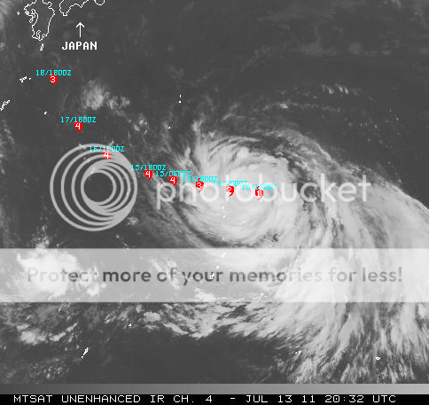
TYPHOON (TY) 08W (MA-ON), LOCATED APPROXIMATELY 500 NM SOUTHEAST OF
IWO TO, JAPAN, HAS TRACKED JUST NORTH OF WESTWARD AT 16 KNOTS OVER
THE PAST SIX HOURS. ANIMATED INFRARED SATELLITE IMAGERY SHOWS THE
SYSTEM HAS BEGUN TO FORM A 10-NM RAGGED EYE. A MICROWAVE EYE IS ALSO
EVIDENT ON A 131707Z AMSU-B PASS. THE INITIAL POSITION IS BASED ON
THE ABOVE ANIMATION WITH HIGH CONFIDENCE. THE INITIAL INTENSITY IS
SUPPORTED BY DVORAK ESTIMATES FROM KNES, RJTD AND PGTW. UPPER LEVEL
ANALYSIS INDICATES THE SYSTEM IS TO THE SOUTH OF THE RIDGE AXIS AND
HAS DEVELOPED A MESOSCALE ANTICYCLONE OVERHEAD. THIS FEATURE,
COUPLED WITH A TROPICAL UPPER TROPOSPHERIC TROUGH 05 DEGREES TO THE
NORTHEAST, ARE PROVIDING EXCELLENT RADIAL OUTFLOW, AS EVIDENT ON
ANIMATED WATER VAPOR IMAGERY. ADDITIONALLY, THE SYSTEM IS TRACKING
ALONG A ZONE OF LOW VERTICAL WIND SHEAR (VWS). TY 08W IS CURRENTLY
TRACKING ALONG THE SOUTHERN PERIPHERY OF A DEEP-LAYERED SUBTROPICAL
RIDGE (STR) ANCHORED EAST OF JAPAN. IT IS EXPECTED TO CONTINUE
TRACKING WESTWARD UP TO TAU 72, AFTERWHICH, THE TRACK BECOMES MORE
NORTHWESTWARD AS THE STEERING RIDGE WEAKENS AND ADJUSTS EASTWARD.
ENVIRONMENTAL CONDITIONS WILL BE FAVORABLE FOR RAPID INTENSIFICATION
TROUGHOUT THIS PERIOD, BRINGING THE PEAK INTENSITY UP TO 135 KNOTS
AT TAU 72. AFTER TAU 72, INCREASING VWS WILL CAUSE THE CYCLONE TO
GRADUALLY WEAKEN. HOWEVER, THE SYSTEM WILL REMAIN A STRONG TYPHOON
WITH INTENSITIES AROUND 100 KNOTS. THE AVAILABLE NUMERICAL GUIDANCE
ARE IN FAIR AGREEMENT UP TO TAU 48 WHERE UKMET AND GFDN REMAIN ON A
WESTWARD TRACK AS A RESULT OF ANTICIPATED DIRECT CYCLONE INTERACTION
(DCI) WITH A DEVELOPING CYCLONE IN THE NORTHERN PHILIPPINE SEA. TO
THE RIGHT OF THE ENVELOPE ARE NOGAPS AND GFS, FAVORING A TIGHTER
TURN IN RESPONSE TO A FASTER-RECEEDING STR. THIS TRACK FORECAST IS
TO THE RIGHT OF CONSENSUS AFTER TAU 48, ACCOUNTING FOR A MINIMAL
DCI. MAXIMUM SIGNIFICANT WAVE HEIGHT AT 131800Z IS 21 FEET. NEXT
WARNINGS AT 140300Z, 140900Z, 141500Z AND 142100Z.//
NNNN

Image
0 likes   
Visit the Caribbean-Central America Weather Thread where you can find at first post web cams,radars
and observations from Caribbean basin members Click Here

User avatar
KWT
Category 5
Category 5
Posts: 31415
Joined: Tue Aug 17, 2004 11:02 am
Location: UK!!!

#195 Postby KWT » Wed Jul 13, 2011 4:37 pm

Peak strength of 135kts would not surprise me one bit, it is a big system afterall...

I do think they are being over agressive however in the next 24hrs...don't think it will gain 30kts in the next 24hrs with that slightly drier air....
0 likes   
Personal Forecast Disclaimer:
The posts in this forum are NOT official forecast and should not be used as such. They are just the opinion of the poster and may or may not be backed by sound meteorological data. They are NOT endorsed by any professional institution or storm2k.org. For official information, please refer to the NHC and NWS products

User avatar
HURAKAN
Professional-Met
Professional-Met
Posts: 46086
Age: 38
Joined: Thu May 20, 2004 4:34 pm
Location: Key West, FL
Contact:

#196 Postby HURAKAN » Wed Jul 13, 2011 4:57 pm

Image

Image

Latest infrared and water vapor
0 likes   

User avatar
KWT
Category 5
Category 5
Posts: 31415
Joined: Tue Aug 17, 2004 11:02 am
Location: UK!!!

#197 Postby KWT » Wed Jul 13, 2011 5:09 pm

Looks like itas already doing a decent job of mixing out any of the dry air...won't be long before we get a really textbook looking system form.
0 likes   
Personal Forecast Disclaimer:
The posts in this forum are NOT official forecast and should not be used as such. They are just the opinion of the poster and may or may not be backed by sound meteorological data. They are NOT endorsed by any professional institution or storm2k.org. For official information, please refer to the NHC and NWS products

User avatar
Fyzn94
Tropical Storm
Tropical Storm
Posts: 190
Joined: Thu Jul 07, 2011 10:00 pm
Location: Central AR, USA

Re: WPAC: MA-ON - Typhoon

#198 Postby Fyzn94 » Wed Jul 13, 2011 5:32 pm

Forecast track:

Image
0 likes   
NOTICE: I cannot give an expert analysis. Most of my "observations" are made visually with the help of only vital information provided by public advisories.

User avatar
KWT
Category 5
Category 5
Posts: 31415
Joined: Tue Aug 17, 2004 11:02 am
Location: UK!!!

#199 Postby KWT » Wed Jul 13, 2011 5:45 pm

Perhapsm a hair north of its forecasted track but to be honest at this stage the wobbles aren't that important in the grand scheme of things.
0 likes   
Personal Forecast Disclaimer:
The posts in this forum are NOT official forecast and should not be used as such. They are just the opinion of the poster and may or may not be backed by sound meteorological data. They are NOT endorsed by any professional institution or storm2k.org. For official information, please refer to the NHC and NWS products

User avatar
cycloneye
Admin
Admin
Posts: 145285
Age: 68
Joined: Thu Oct 10, 2002 10:54 am
Location: San Juan, Puerto Rico

Re: WPAC: MA-ON - Typhoon

#200 Postby cycloneye » Wed Jul 13, 2011 5:54 pm

The dry air disrupted the inner core in the northern semicircle as you can see in this latest microwave image.

Image
0 likes   
Visit the Caribbean-Central America Weather Thread where you can find at first post web cams,radars
and observations from Caribbean basin members Click Here


Return to “2011”

Who is online

Users browsing this forum: No registered users and 13 guests