Pouch 07L approaching Lesser Antilles - (Is invest 90L)

This is the general tropical discussion area. Anyone can take their shot at predicting a storms path.

Moderator: S2k Moderators

Forum rules

The posts in this forum are NOT official forecasts and should not be used as such. They are just the opinion of the poster and may or may not be backed by sound meteorological data. They are NOT endorsed by any professional institution or STORM2K. For official information, please refer to products from the National Hurricane Center and National Weather Service.

Help Support Storm2K
Message
Author
User avatar
cycloneye
Admin
Admin
Posts: 145455
Age: 68
Joined: Thu Oct 10, 2002 10:54 am
Location: San Juan, Puerto Rico

Re: Early start to CV season? Pouch PO7L

#61 Postby cycloneye » Tue Jul 19, 2011 8:45 pm

This wave recently designated pouch PO7L has a big wet field that may reduce the dry conditions in the Atlantic.

http://met.nps.edu/~mtmontgo/P07L.html

Image
0 likes   
Visit the Caribbean-Central America Weather Thread where you can find at first post web cams,radars
and observations from Caribbean basin members Click Here

User avatar
SeminoleWind
Category 1
Category 1
Posts: 359
Age: 50
Joined: Wed Jun 02, 2010 8:37 pm
Location: Lake County Florida

#62 Postby SeminoleWind » Tue Jul 19, 2011 9:00 pm

i wonder when NHC puts another yellow circle on the board for this?
0 likes   
This post is NOT an official forecast and should not be used as such. It is just the opinion of the poster and may or may not be backed by sound meteorological data. It is NOT endorsed by any professional institution including storm2k.org For Official Information please refer to the NHC and NWS products.

User avatar
cycloneye
Admin
Admin
Posts: 145455
Age: 68
Joined: Thu Oct 10, 2002 10:54 am
Location: San Juan, Puerto Rico

Re: Wave in E Atlantic is Pouch PO7L (Develops down the road?)

#63 Postby cycloneye » Tue Jul 19, 2011 9:09 pm

For those members who may be wondering,what the heck is a pouch? :) Well,here is the explanation by this group of scientists that study all about the tropical waves and the model guidance different scenarios for all the waves.

http://met.nps.edu/~mtmontgo/marsupial.html
0 likes   
Visit the Caribbean-Central America Weather Thread where you can find at first post web cams,radars
and observations from Caribbean basin members Click Here

JonathanBelles
Professional-Met
Professional-Met
Posts: 11430
Age: 35
Joined: Sat Dec 24, 2005 9:00 pm
Location: School: Florida State University (Tallahassee, FL) Home: St. Petersburg, Florida
Contact:

#64 Postby JonathanBelles » Tue Jul 19, 2011 9:12 pm

I thought that pouch thing was only a one year program. hmm. One more thing to explain. lol
0 likes   

User avatar
cycloneye
Admin
Admin
Posts: 145455
Age: 68
Joined: Thu Oct 10, 2002 10:54 am
Location: San Juan, Puerto Rico

Re:

#65 Postby cycloneye » Tue Jul 19, 2011 9:20 pm

JonathanBelles wrote:I thought that pouch thing was only a one year program. hmm. One more thing to explain. lol


I thought too that they would not do the research this year as they started around late June. This is their 4th year doing this,and aparently,it looks like they will not stop after 2011.
0 likes   
Visit the Caribbean-Central America Weather Thread where you can find at first post web cams,radars
and observations from Caribbean basin members Click Here

User avatar
stormhunter7
Category 2
Category 2
Posts: 762
Joined: Mon May 26, 2008 3:13 pm
Location: Panama City Beach, Florida
Contact:

Re: Wave in E Atlantic is Pouch PO7L (Develops down the road?)

#66 Postby stormhunter7 » Tue Jul 19, 2011 9:40 pm

Although PREDICT is over, pouch-tracking continues. It was started again for this season on 5 July 2011.


(Per Facebook page)
0 likes   
The following post is NOT an official forecast and should not be used as such. It is just the opinion of the poster and may or may not be backed by sound meteorological data. It is NOT endorsed by any professional institution including storm2k.org For Official Information please refer to the NHC and NWS products. http://www.nhc.noaa.gov

User avatar
Ivanhater
Storm2k Moderator
Storm2k Moderator
Posts: 11162
Age: 38
Joined: Fri Jul 01, 2005 8:25 am
Location: Pensacola

Re: Wave in E Atlantic is Pouch PO7L (Develops down the road?)

#67 Postby Ivanhater » Wed Jul 20, 2011 12:17 am

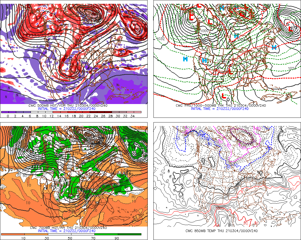
00z Canadian is much more aggressive

Image
0 likes   
Michael

User avatar
Ivanhater
Storm2k Moderator
Storm2k Moderator
Posts: 11162
Age: 38
Joined: Fri Jul 01, 2005 8:25 am
Location: Pensacola

Re: Wave in E Atlantic is Pouch PO7L (Develops down the road?)

#68 Postby Ivanhater » Wed Jul 20, 2011 1:17 am

Well this is interesting...

Ron and I were discussing earlier about the ridge building back in during the long range as this disturbance is approaching the U.S.

The long range Canadian builds the ridge back in and slams it into the SE coast

Image
0 likes   
Michael

User avatar
Hurricaneman
Category 5
Category 5
Posts: 7351
Age: 45
Joined: Tue Aug 31, 2004 3:24 pm
Location: central florida

Re: Wave in E Atlantic is Pouch PO7L (Develops down the road?)

#69 Postby Hurricaneman » Wed Jul 20, 2011 1:17 am

I see mostly troughiness on the canadian which means recurve, but I see a Rebuilding ridge after 144 which means a hit on the southeast coast, if the troughiness stays, might be a threat to bermuda, but if the ridge builds quicker, this could pull something similar to an andrew track, but with much less intensity, bears watching
0 likes   

Brent
S2K Supporter
S2K Supporter
Posts: 38093
Age: 37
Joined: Sun May 16, 2004 10:30 pm
Location: Tulsa Oklahoma
Contact:

Re: Wave in E Atlantic is Pouch PO7L (Develops down the road?)

#70 Postby Brent » Wed Jul 20, 2011 2:10 am

The 0z Euro

Image

Image
Last edited by Brent on Wed Jul 20, 2011 2:57 am, edited 1 time in total.
0 likes   
#neversummer

User avatar
lester
S2K Supporter
S2K Supporter
Posts: 1305
Age: 36
Joined: Sat Aug 27, 2005 5:21 pm
Location: Washington, DC
Contact:

Re: Wave in E Atlantic is Pouch PO7L (Develops down the road?)

#71 Postby lester » Wed Jul 20, 2011 2:21 am

Just in time for your vacation :P
0 likes   

Brent
S2K Supporter
S2K Supporter
Posts: 38093
Age: 37
Joined: Sun May 16, 2004 10:30 pm
Location: Tulsa Oklahoma
Contact:

Re: Wave in E Atlantic is Pouch PO7L (Develops down the road?)

#72 Postby Brent » Wed Jul 20, 2011 2:39 am

lester wrote:Just in time for your vacation :P


Of course... :P
0 likes   
#neversummer

User avatar
somethingfunny
ChatStaff
ChatStaff
Posts: 3926
Age: 37
Joined: Thu May 31, 2007 10:30 pm
Location: McKinney, Texas

#73 Postby somethingfunny » Wed Jul 20, 2011 2:58 am

If this becomes a major hurricane down the line and a huge news story, a lot of us will want to go back to this thread and read the analysis and speculation from the formative stages of the storm, but a lot of the images posted in this thread are going to disappear within 24 hours and all the educational value will be lost!

Please use http://www.tinypic.com or http://www.imageshack.com or another free image hosting website to save your screencaps of model runs, CIMSS analyses, satellite loops, and all other auto-updating jpg pages.

I know it's late, but thanks in advance y'all. :sun:
0 likes   
I am not a meteorologist, and any posts made by me are not official forecasts or to be interpreted as being intelligent. These posts are just my opinions and are probably silly opinions.

User avatar
GCANE
S2K Supporter
S2K Supporter
Posts: 11500
Joined: Mon Oct 22, 2007 8:03 am

Re: Wave in E Atlantic is Pouch PO7L (Develops down the road?)

#74 Postby GCANE » Wed Jul 20, 2011 5:27 am

Good vorticity at 40W from 850mb to 500mb.

GFS showing it will be in a low shear environment to the islands.


http://met.nps.edu/~mtmontgo/storms2011 ... _loop.html

http://met.nps.edu/~mtmontgo/storms2011 ... _loop.html

Image

Image
0 likes   

User avatar
wxman57
Moderator-Pro Met
Moderator-Pro Met
Posts: 22980
Age: 67
Joined: Sat Jun 21, 2003 8:06 pm
Location: Houston, TX (southwest)

Re: Wave in E Atlantic is Pouch PO7L (Develops down the road?)

#75 Postby wxman57 » Wed Jul 20, 2011 5:46 am

Certainly looks like a development threat to me. Quite a circulation developing now on MIMIC imagery. Could be a southeast U.S. threat late next week. Should be an invest today.
0 likes   

User avatar
Vortex
S2K Supporter
S2K Supporter
Posts: 4644
Age: 53
Joined: Fri Aug 01, 2003 9:34 pm
Location: Hilton Head, SC

#76 Postby Vortex » Wed Jul 20, 2011 5:56 am

Nice presentation developing, good environmental conditions. Certainly looks to become a player...
0 likes   

User avatar
GCANE
S2K Supporter
S2K Supporter
Posts: 11500
Joined: Mon Oct 22, 2007 8:03 am

Re: Wave in C Atlantic is Pouch PO7L (Develops down the road?)

#77 Postby GCANE » Wed Jul 20, 2011 6:08 am

The strong water vapor north of the convection looks to me like it is protecting the wave from SAL.


Image


Image


Image
0 likes   

User avatar
cycloneye
Admin
Admin
Posts: 145455
Age: 68
Joined: Thu Oct 10, 2002 10:54 am
Location: San Juan, Puerto Rico

Re: Wave in C Atlantic is Pouch PO7L (Develops down the road?)

#78 Postby cycloneye » Wed Jul 20, 2011 6:39 am

From Crown Weather services:

The following post is NOT an official forecast and should not be used as such. It is just the opinion of the poster and may or may not be backed by sound meteorological data. It is NOT endorsed by any professional institution including storm2k.org. For Official Information please refer to the NHC and NWS products.


http://www.crownweather.com/?page_id=4557

A tropical wave near 40 West Longitude in the eastern Atlantic has had some deeper convection develop around it during the overnight hours. This tropical wave definitely needs to be watched very closely as environmental conditions are expected to be favorable for development for at least the next several days. The only impediment that I see that may prevent this tropical wave from developing into a tropical cyclone is dry, dusty African air just ahead of it between 45 and 55 West Longitude. Even with that, I think this tropical wave will end up becoming our next named storm, Cindy.

The latest Canadian and European model guidance forecasts development into a tropical cyclone with the Canadian model forecasting a track into the Carolinas in about 9 to 10 days from now and the European model guidance forecasting a track into the Gulf of Mexico in about 10 days from now. The GFS model continues to forecast no development from this tropical wave and the NOGAPS model waits to develop this system until it is just east of the Bahamas next Wednesday.

Ok, my analysis is that this tropical wave is showing a good amount of rotation and contains quite a bit of moisture around it. I have a strong suspicion that this will develop into a tropical depression and a tropical storm by this weekend into early next week. Looking further out, the overall pattern for next week may feature a fairly strong and stout ridge of high pressure over the western Atlantic. If this pans out, then this tropical wave may pose a threat to the southeastern US coast or eastern Gulf of Mexico around the middle part of next week. This is just speculation right now and a lot can change with the upper level patterns over the next 7 to 10 days.

I will be monitoring this tropical wave very closely and will definitely keep you all updated on the latest"".
0 likes   
Visit the Caribbean-Central America Weather Thread where you can find at first post web cams,radars
and observations from Caribbean basin members Click Here

User avatar
NDG
S2K Supporter
S2K Supporter
Posts: 15446
Joined: Sun Jul 09, 2006 10:14 pm
Location: Orlando, FL

Re: Wave in C Atlantic is Pouch PO7L (Develops down the road?)

#79 Postby NDG » Wed Jul 20, 2011 6:47 am

cycloneye wrote:From Crownweather services:

http://www.crownweather.com/?page_id=4557

A tropical wave near 40 West Longitude in the eastern Atlantic has had some deeper convection develop around it during the overnight hours. This tropical wave definitely needs to be watched very closely as environmental conditions are expected to be favorable for development for at least the next several days. The only impediment that I see that may prevent this tropical wave from developing into a tropical cyclone is dry, dusty African air just ahead of it between 45 and 55 West Longitude. Even with that, I think this tropical wave will end up becoming our next named storm, Cindy.

The latest Canadian and European model guidance forecasts development into a tropical cyclone with the Canadian model forecasting a track into the Carolinas in about 9 to 10 days from now and the European model guidance forecasting a track into the Gulf of Mexico in about 10 days from now. The GFS model continues to forecast no development from this tropical wave and the NOGAPS model waits to develop this system until it is just east of the Bahamas next Wednesday.

Ok, my analysis is that this tropical wave is showing a good amount of rotation and contains quite a bit of moisture around it. I have a strong suspicion that this will develop into a tropical depression and a tropical storm by this weekend into early next week. Looking further out, the overall pattern for next week may feature a fairly strong and stout ridge of high pressure over the western Atlantic. If this pans out, then this tropical wave may pose a threat to the southeastern US coast or eastern Gulf of Mexico around the middle part of next week. This is just speculation right now and a lot can change with the upper level patterns over the next 7 to 10 days.

I will be monitoring this tropical wave very closely and will definitely keep you all updated on the latest"".


One thing that Rob leaves out about last night's ECMWF run is that before it forecasts the track of the possible system into the GOM is that it tracks it across southern FL.
0 likes   

User avatar
NDG
S2K Supporter
S2K Supporter
Posts: 15446
Joined: Sun Jul 09, 2006 10:14 pm
Location: Orlando, FL

Re: Wave in C Atlantic is Pouch PO7L (Develops down the road?)

#80 Postby NDG » Wed Jul 20, 2011 6:48 am

GCANE wrote:The strong water vapor north of the convection looks to me like it is protecting the wave from SAL.


Image


Image


Image


Yeap, good example of a "pouch" this tropical wave is in.
0 likes   


Return to “Talkin' Tropics”

Who is online

Users browsing this forum: GCANE, Google Adsense [Bot] and 25 guests