

ATL: DON - Remnant - Discussion
Moderator: S2k Moderators
Re: ATL: INVEST 90L - Discussion
CAPE is improving. Currently around 4000. RUC had it at about 3000 a few hours ago.
0 likes
-
Aric Dunn
- Category 5

- Posts: 21238
- Age: 43
- Joined: Sun Sep 19, 2004 9:58 pm
- Location: Ready for the Chase.
- Contact:
The surface circ is likely to develop A little farther west of the blob. 1km visible hints at a weak LLC trying to develop about 20n 85W watch for convection to develop in that area later,.
0 likes
Note: If I make a post that is brief. Please refer back to previous posts for the analysis or reasoning. I do not re-write/qoute what my initial post said each time.
If there is nothing before... then just ask
Space & Atmospheric Physicist, Embry-Riddle Aeronautical University,
I believe the sky is falling...
If there is nothing before... then just ask
Space & Atmospheric Physicist, Embry-Riddle Aeronautical University,
I believe the sky is falling...
-
HouTXmetro

- Category 5
- Posts: 3949
- Joined: Sun Jun 13, 2004 6:00 pm
- Location: District of Columbia, USA

Re: ATL: INVEST 90L - Discussion
GCANE can you tell me and sure others that aren't sure what CAPE is?
0 likes
The following post is NOT an official forecast and should not be used as such. It is just the opinion of the poster and may or may not be backed by sound meteorological data. It is NOT endorsed by any professional institution including storm2k.org For Official Information please refer to the NHC and NWS products.
-
HurricaneBrain

- S2K Supporter

- Posts: 520
- Joined: Thu Jun 30, 2011 2:07 pm
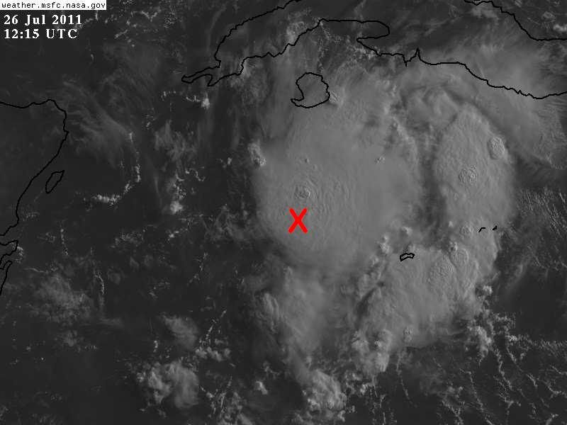
Re:
NDG wrote:I put an X to the 12z NHC best track positioning, there's probably a good 20 miles error out of my part too far south, but you can get the idea.
http://i20.photobucket.com/albums/b245/ ... sxoIC9.jpg
That has the look of a TS! Lol.
0 likes
-
HURAKAN

- Professional-Met

- Posts: 46084
- Age: 39
- Joined: Thu May 20, 2004 4:34 pm
- Location: Key West, FL
- Contact:
Re: ATL: INVEST 90L - Discussion
tailgater wrote:GCANE can you tell me and sure others that aren't sure what CAPE is?
Convective Available Potential Energy (CAPE) is measure of the amount of energy available for convection. CAPE is directly related to the maximum potential vertical speed within an updraft; thus, higher values indicate greater potential for severe weather.
0 likes
Re: ATL: INVEST 90L - Discussion
HURAKAN wrote:tailgater wrote:GCANE can you tell me and sure others that aren't sure what CAPE is?
Convective Available Potential Energy (CAPE) is measure of the amount of energy available for convection. CAPE is directly related to the maximum potential vertical speed within an updraft; thus, higher values indicate greater potential for severe weather.
Thanks Hurakan, I thought from looking at the chart it had something to do with rising air.
0 likes
The following post is NOT an official forecast and should not be used as such. It is just the opinion of the poster and may or may not be backed by sound meteorological data. It is NOT endorsed by any professional institution including storm2k.org For Official Information please refer to the NHC and NWS products.
-
Rgv20

- S2K Supporter
- Posts: 2466
- Age: 39
- Joined: Wed Jan 05, 2011 5:42 pm
- Location: Edinburg/McAllen Tx
Sorry I would provide some maps but Im at work
0 likes
The following post is NOT an official forecast and should not be used as such. It is just the opinion of the poster and may or may not be backed by sound meteorological data. It is NOT endorsed by any professional institution including storm2k.org For Official Information please refer to the NHC and NWS products.
Re: ATL: INVEST 90L - Discussion
HURAKAN wrote:tailgater wrote:GCANE can you tell me and sure others that aren't sure what CAPE is?
Convective Available Potential Energy (CAPE) is measure of the amount of energy available for convection. CAPE is directly related to the maximum potential vertical speed within an updraft; thus, higher values indicate greater potential for severe weather.
Thanks Sandy.
0 likes
-
latitude_20

- Tropical Storm

- Posts: 196
- Joined: Wed Jun 30, 2010 6:46 am
- Location: Tulum, Mexico
- Contact:

Re: ATL: INVEST 90L - Discussion
My guess as to where a LLC may be forming. 21.1N 82 6W.

0 likes
The following post is NOT an official forecast and should not be used as such. It is just the opinion of the poster and may or may not be backed by sound meteorological data. It is NOT endorsed by any professional institution including storm2k.org For Official Information please refer to the NHC and NWS products.
-
Stormcenter
- S2K Supporter
- Posts: 6689
- Joined: Wed Sep 03, 2003 11:27 am
- Location: Houston, TX
90L looks like it is getting it's act together this morning.
http://www.ssd.noaa.gov/goes/east/gmex/flash-vis.html
http://www.ssd.noaa.gov/goes/east/gmex/flash-vis.html
0 likes
-
SouthDadeFish

- Professional-Met
- Posts: 2835
- Joined: Thu Sep 23, 2010 2:54 pm
- Location: Miami, FL
- Contact:
Low level inflow is much better than yesterday on the western side. In my opinion, this definitely should be code orange, and code red isn't the unreasonable given current environmental conditions. The environment is moist, wind shear is dropping, and SSTs are very warm. It seems like 90L is on its way to becoming our next tropical cyclone.
0 likes
-
tolakram
- Admin

- Posts: 20176
- Age: 62
- Joined: Sun Aug 27, 2006 8:23 pm
- Location: Florence, KY (name is Mark)
Re: ATL: INVEST 90L - Discussion
They switched to high speed scanning some time this morning.
http://wwwghcc.msfc.nasa.gov/cgi-bin/ge ... umframes=5
remember you can edit this URL to change location and num frames, etc.
Looks like west cloud movement starting to the left of the blob.
http://wwwghcc.msfc.nasa.gov/cgi-bin/ge ... umframes=5
remember you can edit this URL to change location and num frames, etc.
Code: Select all
http://wwwghcc.msfc.nasa.gov/cgi-bin/get-goes?satellite=GOES-E%20CONUS&lat=20&lon=-83&info=vis&zoom=1&width=1024&height=800&type=Animation&quality=90&numframes=5Looks like west cloud movement starting to the left of the blob.
Last edited by tolakram on Tue Jul 26, 2011 9:33 am, edited 1 time in total.
0 likes
M a r k
- - - - -
Join us in chat: Storm2K Chatroom Invite. Android and IOS apps also available.
The posts in this forum are NOT official forecasts and should not be used as such. Posts are NOT endorsed by any professional institution or STORM2K.org. For official information and forecasts, please refer to NHC and NWS products.

-
SouthDadeFish
- Professional-Met
- Posts: 2835
- Joined: Thu Sep 23, 2010 2:54 pm
- Location: Miami, FL
- Contact:
Re:
NDG wrote:I am starting to see now a SW inflow of low level clouds into the storms, very close to the 12z best of track positioning by the NHC. We could have a weak LLC now developing. Deep convection continues refire. The MLC is still very noticeable south of the Isle of Youth.
That's what I'm watching as well. Once that inflow switches to a more westerly direction, then we have a LLC. 90L is very close.
0 likes
-
Ivanhater

- Storm2k Moderator

- Posts: 11221
- Age: 39
- Joined: Fri Jul 01, 2005 8:25 am
- Location: Pensacola
Re: ATL: INVEST 90L - Discussion
Would you look at that....still organizing like some of us suspected yesterday evening.
0 likes
Michael

Much improved since yesterday, convection is stronger though its still a little unstable with no one area being dominant for more than 6hrs which is probably the main reason why any LLC hasn't formed...convection is decent but for the Caribbean its nothing too outlandish.
This is where Dolly pulled it together in 2008...could well be se eing a similar thing trying to happen here.
This is where Dolly pulled it together in 2008...could well be se eing a similar thing trying to happen here.
Last edited by KWT on Tue Jul 26, 2011 9:37 am, edited 1 time in total.
0 likes
Personal Forecast Disclaimer:
The posts in this forum are NOT official forecast and should not be used as such. They are just the opinion of the poster and may or may not be backed by sound meteorological data. They are NOT endorsed by any professional institution or storm2k.org. For official information, please refer to the NHC and NWS products
The posts in this forum are NOT official forecast and should not be used as such. They are just the opinion of the poster and may or may not be backed by sound meteorological data. They are NOT endorsed by any professional institution or storm2k.org. For official information, please refer to the NHC and NWS products
-
Ivanhater
- Storm2k Moderator
- Posts: 11221
- Age: 39
- Joined: Fri Jul 01, 2005 8:25 am
- Location: Pensacola
Re: ATL: INVEST 90L - Discussion
Hurricane hunters tagged a flight
WEATHER RECONNAISSANCE FLIGHTS
CARCAH, NATIONAL HURRICANE CENTER, MIAMI, FL.
1030 AM EDT TUE 26 JULY 2011
SUBJECT: TROPICAL CYCLONE PLAN OF THE DAY (TCPOD)
VALID 27/1100Z TO 28/1100Z JULY 2011
TCPOD NUMBER.....11-056
I. ATLANTIC REQUIREMENTS
1. SUSPECT AREA (NEAR TIP OF YUCATAN)
FLIGHT ONE -- TEAL 70
A. 27/1800Z
B. AFXXX 01DDA INVEST
C. 27/1530Z
D. 22.0N 87.0W
E. 27/1730Z TO 27/2130Z
F. SFC TO 10,000 FT
2. OUTLOOK FOR SUCCEEDING DAY: BEGIN 6-HRLY FIXES
AT 28/1200Z NEAR 23.0N 91.5W IF SYSTEM DEVELOPS.
0 likes
Michael
-
SouthDadeFish
- Professional-Met
- Posts: 2835
- Joined: Thu Sep 23, 2010 2:54 pm
- Location: Miami, FL
- Contact:
Who is online
Users browsing this forum: No registered users and 3 guests