ATL: EMILY - Remnants

Moderator: S2k Moderators

Message
Author
User avatar
cycloneye
Admin
Admin
Posts: 143897
Age: 68
Joined: Thu Oct 10, 2002 10:54 am
Location: San Juan, Puerto Rico

Re: ATL: EMILY - Tropical Storm - Discussion

#3821 Postby cycloneye » Mon Aug 01, 2011 9:16 pm

knotimpaired wrote:9:34 and no discussion since?

Is this what they mean that once it is named, everyone forgets it? The fun is gone?


What do you mean? I posted for you the radar that shows a band approaching your location and the members are discussing about it.
0 likes   
Visit the Caribbean-Central America Weather Thread where you can find at first post web cams,radars
and observations from Caribbean basin members Click Here

SunnyThoughts
Category 5
Category 5
Posts: 2263
Joined: Wed Jul 09, 2003 12:42 pm
Location: Pensacola, Florida

#3822 Postby SunnyThoughts » Mon Aug 01, 2011 9:16 pm

wow curious to see where it ends up this run.
0 likes   

stormreader

Re: ATL: EMILY - Models

#3823 Postby stormreader » Mon Aug 01, 2011 9:17 pm

I tell you the persistent model support for ridging north of the storm and the strong W motion now make me feel more confident that the forecast track will remain at the western side of the envelope and eventually will have to be nudged into the E GOM. Considering where models have been recently (well east of Fl--some still there) I give the NHC quite a bit of credit for placing their track along that western side of the envelope. I think its not far off from the eventual track, and if anything will only have to be nudged west a little and not east.
Just an amateur opinion here.
0 likes   

Aric Dunn
Category 5
Category 5
Posts: 21238
Age: 42
Joined: Sun Sep 19, 2004 9:58 pm
Location: Ready for the Chase.
Contact:

Re: ATL: EMILY - Models

#3824 Postby Aric Dunn » Mon Aug 01, 2011 9:19 pm

Ivanhater wrote:00Z NAM looks really far south..remember Ivan and others...kept on going west against the models and the models had to play catch up almost the entire time....I know we all try to nail these systems down as soon as we can, but this is certainly not clear cut as most logical people will tell you.

[img]http://www.nco.ncep.noaa.gov/pmb/nwprod/analysis/carib/nam/00/images/nam_sl8_030m.gif[/img


Yeah the fact that presently the ridging is holding and seems slightly stronger than earlier in the day gives more credence to the more west models..
0 likes   
Note: If I make a post that is brief. Please refer back to previous posts for the analysis or reasoning. I do not re-write/qoute what my initial post said each time.
If there is nothing before... then just ask :)

Space & Atmospheric Physicist, Embry-Riddle Aeronautical University,
I believe the sky is falling...

User avatar
TheDreamTraveler
Category 2
Category 2
Posts: 641
Joined: Sun Aug 22, 2010 3:10 am
Location: PA

Re: ATL: EMILY - Tropical Storm - Discussion

#3825 Postby TheDreamTraveler » Mon Aug 01, 2011 9:19 pm

Is it weird to see the most intense area of convection transfer from the west to the east side so quickly? Almost like it was going around in a loop.

http://www.ssd.noaa.gov/goes/east/catl/flash-avn.html
Last edited by TheDreamTraveler on Mon Aug 01, 2011 9:20 pm, edited 1 time in total.
0 likes   

User avatar
knotimpaired
Category 1
Category 1
Posts: 495
Joined: Fri May 20, 2005 4:14 am
Location: Vieques, PR
Contact:

Re: ATL: EMILY - Tropical Storm - Discussion

#3826 Postby knotimpaired » Mon Aug 01, 2011 9:19 pm

HurricaneBelle wrote:
knotimpaired wrote:9:34 and no discussion since?

Is this what they mean that once it is named, everyone forgets it? The fun is gone?


Refresh. F5 isn't just a code for an extreme tornado.


You are far ahead of me to suggest to refresh. I have no clue what you are referring to.

I do know this though.

1. I believe in Cycloneye

2. I believe in Aric

3. I believe in MJ, PRCarib

That is who I will listen to.
0 likes   

Florida1118

Re: ATL: EMILY - Tropical Storm - Discussion

#3827 Postby Florida1118 » Mon Aug 01, 2011 9:20 pm

cycloneye wrote:
knotimpaired wrote:9:34 and no discussion since?

Is this what they mean that once it is named, everyone forgets it? The fun is gone?


What do you mean? I posted for you the radar that shows a band approaching your location and the members are discussing about it.

Also it could be people just want to take a break from her now that she's named. Its been like pulling teeth waiting for the upgrade, and its here now so we can all sit back and watch
0 likes   

User avatar
Rgv20
S2K Supporter
S2K Supporter
Posts: 2466
Age: 38
Joined: Wed Jan 05, 2011 5:42 pm
Location: Edinburg/McAllen Tx

#3828 Postby Rgv20 » Mon Aug 01, 2011 9:20 pm

Well assuming Emily follows the NHC Cone that is one unusually strong through that she is going to encounter.

12zECMWF Ensembles forecast for 96hrs
Image

12zGFS Ensembles forecast for 96hrs
Image


Also the 6zGFS Ensembles show enough ridging that it could be a possible threat to Florida. The gold lines show that some of the Ensemble members forecast a ridge to take over just to the east of Florida.
Image
0 likes   
The following post is NOT an official forecast and should not be used as such. It is just the opinion of the poster and may or may not be backed by sound meteorological data. It is NOT endorsed by any professional institution including storm2k.org For Official Information please refer to the NHC and NWS products.

Aric Dunn
Category 5
Category 5
Posts: 21238
Age: 42
Joined: Sun Sep 19, 2004 9:58 pm
Location: Ready for the Chase.
Contact:

#3829 Postby Aric Dunn » Mon Aug 01, 2011 9:21 pm

Other thing is .. the current motion of emily has WSW component so the NAM with the stronger ridge may be not too far of..
0 likes   
Note: If I make a post that is brief. Please refer back to previous posts for the analysis or reasoning. I do not re-write/qoute what my initial post said each time.
If there is nothing before... then just ask :)

Space & Atmospheric Physicist, Embry-Riddle Aeronautical University,
I believe the sky is falling...

User avatar
cheezyWXguy
Category 5
Category 5
Posts: 6092
Joined: Mon Feb 13, 2006 12:29 am
Location: Dallas, TX

Re: ATL: EMILY - Tropical Storm - Discussion

#3830 Postby cheezyWXguy » Mon Aug 01, 2011 9:22 pm

knotimpaired wrote:
HurricaneBelle wrote:
knotimpaired wrote:9:34 and no discussion since?

Is this what they mean that once it is named, everyone forgets it? The fun is gone?


Refresh. F5 isn't just a code for an extreme tornado.


You are far ahead of me to suggest to refresh. I have no clue what you are referring to.

I do know this though.

1. I believe in Cycloneye

2. I believe in Aric

3. I believe in MJ, PRCarib

That is who I will listen to.

Hes saying to refresh the page. Press F5 periodically to update the page and see the latest posts.
0 likes   

User avatar
LSU2001
S2K Supporter
S2K Supporter
Posts: 1711
Age: 57
Joined: Sat Sep 11, 2004 11:01 pm
Location: Cut Off, Louisiana

Re: ATL: EMILY - Tropical Storm - Discussion

#3831 Postby LSU2001 » Mon Aug 01, 2011 9:22 pm

knotimpaired,
He simply means to reload your page. If you hit the f5 key on your keyboard it will reload the page and show any new posts since the last time you loaded the page.
Hope this helps,
Tim
0 likes   
Personal Forecast Disclaimer:
The posts in this forum are NOT official forecast and should not be used as such. They are NOT endorsed by any professional institution or storm2k.org. For official information, please refer to the NHC and NWS products.

Aric Dunn
Category 5
Category 5
Posts: 21238
Age: 42
Joined: Sun Sep 19, 2004 9:58 pm
Location: Ready for the Chase.
Contact:

#3832 Postby Aric Dunn » Mon Aug 01, 2011 9:24 pm

0 likes   
Note: If I make a post that is brief. Please refer back to previous posts for the analysis or reasoning. I do not re-write/qoute what my initial post said each time.
If there is nothing before... then just ask :)

Space & Atmospheric Physicist, Embry-Riddle Aeronautical University,
I believe the sky is falling...

User avatar
Nimbus
Category 5
Category 5
Posts: 5274
Joined: Mon Jul 19, 2004 10:54 am

Re: ATL: EMILY - Models

#3833 Postby Nimbus » Mon Aug 01, 2011 9:24 pm

Looking at the water vapor imagery there is an ULL rolling west over the Yucatan and Emily is embedded in the subtropical ridge currently pushing west past Jamaica. I see a trough dropping down now just south of the Georgia Florida border but it would really have to dig for Emily to feel its effects way down at 16 N. I saw Emily passing over the high mountains of Haiti 48 hours ago but now with the the current ridging and 00Z Nam it looks like I might be out.
0 likes   

User avatar
knotimpaired
Category 1
Category 1
Posts: 495
Joined: Fri May 20, 2005 4:14 am
Location: Vieques, PR
Contact:

Re: ATL: EMILY - Tropical Storm - Discussion

#3834 Postby knotimpaired » Mon Aug 01, 2011 9:24 pm

Florida1118 wrote:
cycloneye wrote:
knotimpaired wrote:9:34 and no discussion since?

Is this what they mean that once it is named, everyone forgets it? The fun is gone?


What do you mean? I posted for you the radar that shows a band approaching your location and the members are discussing about it.


Also it could be people just want to take a break from her now that she's named. Its been like pulling teeth waiting for the upgrade, and its here now so we can all sit back and watch


Luis Sorry. Let me take a look at our long range forecast.

Lee's 2 daughters and grandchildren have proven to be a handful.
0 likes   

User avatar
Evil Jeremy
S2K Supporter
S2K Supporter
Posts: 5463
Age: 31
Joined: Mon Apr 10, 2006 2:10 pm
Location: Los Angeles, CA

#3835 Postby Evil Jeremy » Mon Aug 01, 2011 9:25 pm

Looking forward to the new Discussion. I wonder how the NHC will handle the new model run.
0 likes   
Frances 04 / Jeanne 04 / Katrina 05 / Wilma 05 / Fay 08 / Debby 12 / Andrea 13 / Colin 16 / Hermine 16 / Matthew 16 / Irma 17

User avatar
Clint_TX
Tropical Storm
Tropical Storm
Posts: 197
Joined: Thu May 01, 2003 8:31 am

Re: ATL: EMILY - Tropical Storm - Discussion

#3836 Postby Clint_TX » Mon Aug 01, 2011 9:26 pm

Large circ on this system...starting to be impressed, its establishing at the lower levels nicely
0 likes   

DIwestender
Tropical Low
Tropical Low
Posts: 31
Joined: Wed Jul 16, 2008 11:56 pm
Location: Dauphin Island, AL

Re: ATL: EMILY - Tropical Storm - Discussion

#3837 Postby DIwestender » Mon Aug 01, 2011 9:26 pm

Actually, I never knew you could hit F5 and it would refresh the page. Thanks for that tip! As for Emily, I am watching with great interest and I appreciate all the input.
0 likes   

User avatar
Blown Away
S2K Supporter
S2K Supporter
Posts: 10140
Joined: Wed May 26, 2004 6:17 am

Re: ATL: EMILY - Models

#3838 Postby Blown Away » Mon Aug 01, 2011 9:27 pm

gatorcane wrote:
PTrackerLA wrote:NHC's path looks too far west given current model suite. They will definitely have to adjust their track some at 10pm.


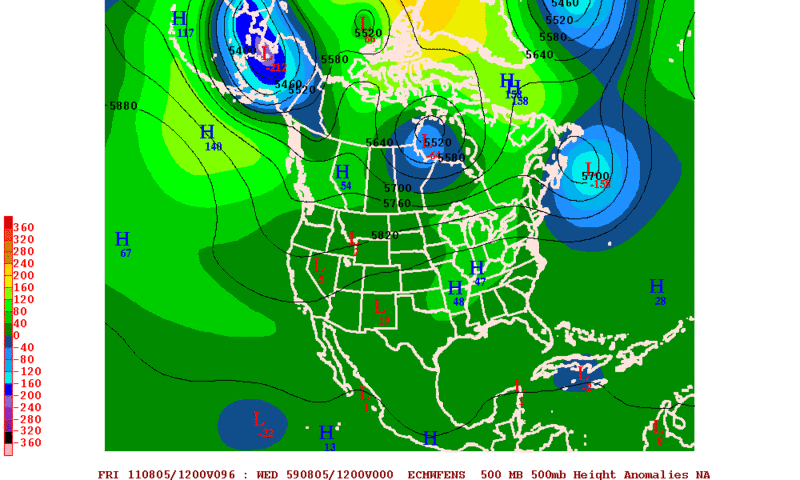
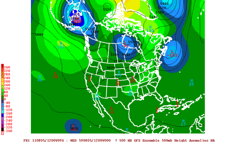
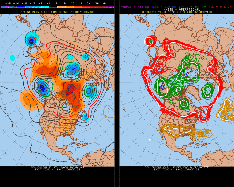
I agree only the CMC and UKMET are into Florida. I am not counting the NOGAPS.

The other reliable models are converging over the Bahamas. A right shift should be coming.

Those BAMs are really recurving it now. Though not really counting those.


IMO, some models begin the recurve, slow significantly, and some stall, Emily gets trapped under a building ridge and forced back W (TVCN, BAMD, NOGAPS). Maybe a Jeanne type setup??
Last edited by Blown Away on Mon Aug 01, 2011 9:28 pm, edited 1 time in total.
0 likes   
Hurricane Eye Experience: David 79, Irene 99, Frances 04, Jeanne 04, Wilma 05... EYE COMING MY WAY IN 2024…
Hurricane Brush Experience: Andrew 92, Erin 95, Floyd 99, Matthew 16, Irma 17, Ian 22, Nicole 22…

User avatar
cycloneye
Admin
Admin
Posts: 143897
Age: 68
Joined: Thu Oct 10, 2002 10:54 am
Location: San Juan, Puerto Rico

Re: ATL: EMILY - Tropical Storm - Discussion

#3839 Postby cycloneye » Mon Aug 01, 2011 9:28 pm

knotimpaired,if you have observations from Vieques,post them at the Caribbean thread as I know you have a weather station.
0 likes   
Visit the Caribbean-Central America Weather Thread where you can find at first post web cams,radars
and observations from Caribbean basin members Click Here

Aric Dunn
Category 5
Category 5
Posts: 21238
Age: 42
Joined: Sun Sep 19, 2004 9:58 pm
Location: Ready for the Chase.
Contact:

#3840 Postby Aric Dunn » Mon Aug 01, 2011 9:28 pm

funny last night the NAM showed stronger ridging and the 00z then 12z globals all showed it shift their tracks west a bunch.. each run the models seem to initialize the ridge being to weak except a couple...
0 likes   
Note: If I make a post that is brief. Please refer back to previous posts for the analysis or reasoning. I do not re-write/qoute what my initial post said each time.
If there is nothing before... then just ask :)

Space & Atmospheric Physicist, Embry-Riddle Aeronautical University,
I believe the sky is falling...


Return to “2011”

Who is online

Users browsing this forum: No registered users and 58 guests