
Global model runs discussion
Moderator: S2k Moderators
-
HurricaneBrain

- S2K Supporter

- Posts: 520
- Joined: Thu Jun 30, 2011 2:07 pm
-
cycloneye

- Admin

- Posts: 149514
- Age: 69
- Joined: Thu Oct 10, 2002 10:54 am
- Location: San Juan, Puerto Rico
Re: Global Model Runs Discussion
Longtracker by GFS
12z GFS continues to show a CV longtracker that forms from one of the waves that are still inside Africa.
12z GFS Loop
12z GFS continues to show a CV longtracker that forms from one of the waves that are still inside Africa.
12z GFS Loop
0 likes
Visit the Caribbean-Central America Weather Thread where you can find at first post web cams,radars
and observations from Caribbean basin members Click Here
and observations from Caribbean basin members Click Here
-
cycloneye
- Admin
- Posts: 149514
- Age: 69
- Joined: Thu Oct 10, 2002 10:54 am
- Location: San Juan, Puerto Rico
Re: Global Model Runs Discussion
The 12z ECMWF has a wave developing,but the timeframe suggests is another one as by 192 hours,GFS has the longtracker north of PR.

0 likes
Visit the Caribbean-Central America Weather Thread where you can find at first post web cams,radars
and observations from Caribbean basin members Click Here
and observations from Caribbean basin members Click Here
-
ConvergenceZone
.gif)
- Category 5

- Posts: 5241
- Joined: Fri Jul 29, 2005 1:40 am
- Location: Northern California
-
cycloneye
- Admin
- Posts: 149514
- Age: 69
- Joined: Thu Oct 10, 2002 10:54 am
- Location: San Juan, Puerto Rico
Re:
ConvergenceZone wrote:Keem them model plots coming....good stuff!
When the Euro speaks,you have to pay close attention
0 likes
Visit the Caribbean-Central America Weather Thread where you can find at first post web cams,radars
and observations from Caribbean basin members Click Here
and observations from Caribbean basin members Click Here
-
ConvergenceZone
- Category 5
- Posts: 5241
- Joined: Fri Jul 29, 2005 1:40 am
- Location: Northern California
Re: Re:
cycloneye wrote:ConvergenceZone wrote:Keem them model plots coming....good stuff!
When the Euro speaks,you have to pay close attentionAnd if you have that and GFS,it means the best consensus you can have between the top two models.
It just seems like everything that's been coming off the coast has been fizzling so quick!
0 likes
-
HurricaneMaster_PR

- Category 2

- Posts: 795
- Joined: Tue Jul 22, 2003 6:23 pm
- Location: San Juan, Puerto Rico
Re: Re:
cycloneye wrote:ConvergenceZone wrote:Keem them model plots coming....good stuff!
When the Euro speaks,you have to pay close attention
The ECMWF was very good with Emily. So lets pay close attention to this models as the Cape Verde Season is getting ready to begin!
0 likes

both ECm/GFS show a upper high to the north of this system which moves west as well...
My gut would be saying this could be a player but we'll need to see how it handles coming offland...
GFS much faster with this system as well...
My gut would be saying this could be a player but we'll need to see how it handles coming offland...
GFS much faster with this system as well...
0 likes
Personal Forecast Disclaimer:
The posts in this forum are NOT official forecast and should not be used as such. They are just the opinion of the poster and may or may not be backed by sound meteorological data. They are NOT endorsed by any professional institution or storm2k.org. For official information, please refer to the NHC and NWS products
The posts in this forum are NOT official forecast and should not be used as such. They are just the opinion of the poster and may or may not be backed by sound meteorological data. They are NOT endorsed by any professional institution or storm2k.org. For official information, please refer to the NHC and NWS products
-
cycloneye
- Admin
- Posts: 149514
- Age: 69
- Joined: Thu Oct 10, 2002 10:54 am
- Location: San Juan, Puerto Rico
Re: Global Model Runs Discussion
Another run (18Z) by GFS showing CV development. It starts at 36 hours.

Uploaded by Imageshack.us
Uploaded by Imageshack.us
0 likes
Visit the Caribbean-Central America Weather Thread where you can find at first post web cams,radars
and observations from Caribbean basin members Click Here
and observations from Caribbean basin members Click Here
-
cycloneye
- Admin
- Posts: 149514
- Age: 69
- Joined: Thu Oct 10, 2002 10:54 am
- Location: San Juan, Puerto Rico
Re: Global Model Runs Discussion
0 likes
Visit the Caribbean-Central America Weather Thread where you can find at first post web cams,radars
and observations from Caribbean basin members Click Here
and observations from Caribbean basin members Click Here
Don't think thats the system Cycloneye, the system buries itself into Caribbean after decaying, If you track the Vort its quite obvious the system hits CA in the end.
0 likes
Personal Forecast Disclaimer:
The posts in this forum are NOT official forecast and should not be used as such. They are just the opinion of the poster and may or may not be backed by sound meteorological data. They are NOT endorsed by any professional institution or storm2k.org. For official information, please refer to the NHC and NWS products
The posts in this forum are NOT official forecast and should not be used as such. They are just the opinion of the poster and may or may not be backed by sound meteorological data. They are NOT endorsed by any professional institution or storm2k.org. For official information, please refer to the NHC and NWS products
-
cycloneye
- Admin
- Posts: 149514
- Age: 69
- Joined: Thu Oct 10, 2002 10:54 am
- Location: San Juan, Puerto Rico
Re:
KWT wrote:Don't think thats the system Cycloneye, the system buries itself into Caribbean after decaying, If you track the Vort its quite obvious the system hits CA in the end.
I guess we have to wait another day or two to see a more clear picture about which wave is what the models are latching on.
0 likes
Visit the Caribbean-Central America Weather Thread where you can find at first post web cams,radars
and observations from Caribbean basin members Click Here
and observations from Caribbean basin members Click Here
-
Rgv20

- S2K Supporter
- Posts: 2466
- Age: 39
- Joined: Wed Jan 05, 2011 5:42 pm
- Location: Edinburg/McAllen Tx
Very interesting cycloneye, that the GFS has been persistent on developing a system starting this Sunday..I guess we are going to find out soon if the GFS solution is going to verify.
The Euro has been really consisting on showing CV development starting late next week until the weekend. When the Euro starts been persisting its hard to ignore even though its 7 to 9 days out.
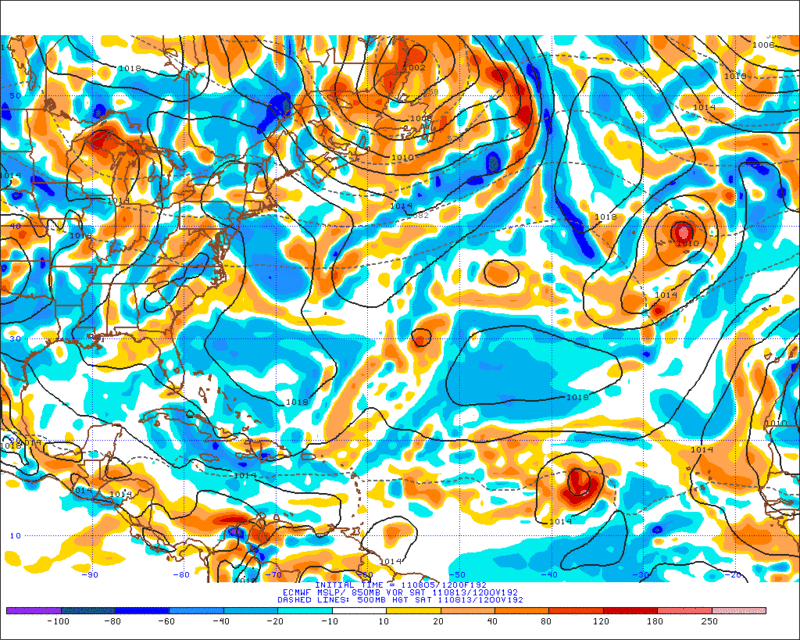
12zECMWF forecast 850mb vorticity valid for Saturday (Aug13). Development looks to be around 15n and 36w (Per Accuweather Pro)
The Euro has been really consisting on showing CV development starting late next week until the weekend. When the Euro starts been persisting its hard to ignore even though its 7 to 9 days out.
12zECMWF forecast 850mb vorticity valid for Saturday (Aug13). Development looks to be around 15n and 36w (Per Accuweather Pro)
0 likes
The following post is NOT an official forecast and should not be used as such. It is just the opinion of the poster and may or may not be backed by sound meteorological data. It is NOT endorsed by any professional institution including storm2k.org For Official Information please refer to the NHC and NWS products.

-
somethingfunny

- ChatStaff

- Posts: 3926
- Age: 37
- Joined: Thu May 31, 2007 10:30 pm
- Location: McKinney, Texas
I have a very tough time buying the GFS solution of a storm developing east of the Cape Verde Islands around 12-13N and making it all the way across to Puerto Rico.
0 likes
I am not a meteorologist, and any posts made by me are not official forecasts or to be interpreted as being intelligent. These posts are just my opinions and are probably silly opinions.
-
SFLcane

- S2K Supporter
- Posts: 10281
- Age: 48
- Joined: Sat Jun 05, 2010 1:44 pm
- Location: Lake Worth Florida
Re: Global Model Runs Discussion
ROCK wrote:at 15N that would be a classic recurve TC....
At 15 north it doesn't have much chance getting through the east coast trough.
0 likes

Re: Global Model Runs Discussion
If development does pick up...i think it will start really ramping up by august 20th...
0 likes
Current pattern means its going to be very very difficult to get a US landfall, probably the best way is a weak system makes it to neasr the Bahamas and explodes just at the same time as some brief ridging comes in, but the pattern is TROUGHY in a big way, just loike last yeaer, in fact almost a clone of last year.
0 likes
Personal Forecast Disclaimer:
The posts in this forum are NOT official forecast and should not be used as such. They are just the opinion of the poster and may or may not be backed by sound meteorological data. They are NOT endorsed by any professional institution or storm2k.org. For official information, please refer to the NHC and NWS products
The posts in this forum are NOT official forecast and should not be used as such. They are just the opinion of the poster and may or may not be backed by sound meteorological data. They are NOT endorsed by any professional institution or storm2k.org. For official information, please refer to the NHC and NWS products

Re: Global Model Runs Discussion
It's fantasy land but 06z GFS shows a big ramp up in activity the next 2 weeks. BTW, the GOM storm is the one supposed to come off Africa in the next few days.

0 likes
-
cycloneye
- Admin
- Posts: 149514
- Age: 69
- Joined: Thu Oct 10, 2002 10:54 am
- Location: San Juan, Puerto Rico
Re: Global Model Runs Discussion
I would like to see a bit more enthusiasm by ECMWF before I start to believe entirely what GFS has been showing for the past two days of consecutive runs.But as I said before,there is no doubt that the models are sniffing the start of the CV season in earnest.
0 likes
Visit the Caribbean-Central America Weather Thread where you can find at first post web cams,radars
and observations from Caribbean basin members Click Here
and observations from Caribbean basin members Click Here
Who is online
Users browsing this forum: No registered users and 30 guests