ATL: EMILY - Remnants
Moderator: S2k Moderators

Yep moisture could well get sheared off,the models that keep it drier are probably not noticing there is probably a redeveloping TC out there at the moment, so thats why I suspect they are underdoing moisture return a little over Florida.
0 likes
Personal Forecast Disclaimer:
The posts in this forum are NOT official forecast and should not be used as such. They are just the opinion of the poster and may or may not be backed by sound meteorological data. They are NOT endorsed by any professional institution or storm2k.org. For official information, please refer to the NHC and NWS products
The posts in this forum are NOT official forecast and should not be used as such. They are just the opinion of the poster and may or may not be backed by sound meteorological data. They are NOT endorsed by any professional institution or storm2k.org. For official information, please refer to the NHC and NWS products


Re: Re:
TheBurn wrote:mutley wrote:Could someone please post a link to the mimic?
http://cimss.ssec.wisc.edu/tropic/real- ... /main.html
Thanks. Much appreciated.
0 likes
The preceding comments are never to be used as information to establish circumstances, plans or procedures for any weather related events. Only use official National Hurricane Center or National Weather Service information issued for your area.
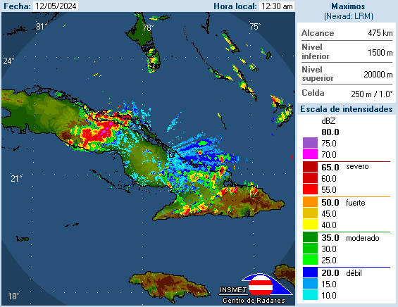
looking pretty good on Cuban radar here -
http://www.insmet.cu/asp/genesis.asp?TB ... AXw01a.gif
wish they had longer loops.
http://www.insmet.cu/asp/genesis.asp?TB ... AXw01a.gif
wish they had longer loops.
0 likes

Re:
Nope! I just joined.
I was really surprised when Emily fell apart like that. I read in the news about the flare and then saw it mentioned here... well two synapses got together and I thought maybe there's a correlation.
I was really surprised when Emily fell apart like that. I read in the news about the flare and then saw it mentioned here... well two synapses got together and I thought maybe there's a correlation.
WilmingtonSandbar wrote:one wonders if Gcane and TAD are one and the same?
0 likes
The above post is not official and should not be used as such. It is the opinion of the poster and may or may not be backed by sound meteorological data. It is not endorsed by any professional institution or storm2k.org. For official information, please refer to the NHC and NWS products.


Yep I noticed that, of course if anything of any real strengvth gets going its going to pretty rapidly evacuate NNW/N and eventually out to sea still I'd suspect.
0 likes
Personal Forecast Disclaimer:
The posts in this forum are NOT official forecast and should not be used as such. They are just the opinion of the poster and may or may not be backed by sound meteorological data. They are NOT endorsed by any professional institution or storm2k.org. For official information, please refer to the NHC and NWS products
The posts in this forum are NOT official forecast and should not be used as such. They are just the opinion of the poster and may or may not be backed by sound meteorological data. They are NOT endorsed by any professional institution or storm2k.org. For official information, please refer to the NHC and NWS products

Re: Re:
wzrgirl1 wrote:WilmingtonSandbar wrote:one wonders if Gcane and TAD are one and the same?
Totally hysterical because I was thinking the same thing.
Honestly no, but a good part of the northern US could see the aurora tonight.
http://www.softservenews.com/aurora.htm
0 likes

How about the latest IR...Much more circular and slowly moving NW..Should pass just west of Andros over the next 6-12 hours...I have little doubt should be at TS status tomorrow...
http://www.ghcc.msfc.nasa.gov/GOES/goeseastconusir.html
http://www.ghcc.msfc.nasa.gov/GOES/goeseastconusir.html
0 likes
-
Aric Dunn
- Category 5

- Posts: 21238
- Age: 43
- Joined: Sun Sep 19, 2004 9:58 pm
- Location: Ready for the Chase.
- Contact:
Re:
gatorcane wrote:Yeah I am not sure why they would not mention South Florida in that TWO...doesn't make sense really, especially when you look at the GFS and see that the 18Z run shows a stronger ridge north of the system right now as compared to what the 12Z forecasted there to be at this time......
that and if the system does somehow get vertically stacked the 300mb flow is mostly east to west... so it would feel the effects of that a little and probably struggle to turn at first..
0 likes
Note: If I make a post that is brief. Please refer back to previous posts for the analysis or reasoning. I do not re-write/qoute what my initial post said each time.
If there is nothing before... then just ask
Space & Atmospheric Physicist, Embry-Riddle Aeronautical University,
I believe the sky is falling...
If there is nothing before... then just ask
Space & Atmospheric Physicist, Embry-Riddle Aeronautical University,
I believe the sky is falling...
-
cycloneye

- Admin

- Posts: 149431
- Age: 69
- Joined: Thu Oct 10, 2002 10:54 am
- Location: San Juan, Puerto Rico
Re: ATL: EMILY - Remnants - Discussion
The posts in this forum are NOT official forecast and should not be used as such. They are just the opinion of the poster and may or may not be backed by sound meteorological data. They are NOT endorsed by any professional institution or storm2k.org. For official information, please refer to the NHC and NWS products.
If actual trends continue thru Saturday afternoon,recon will find a TD or TS.
If actual trends continue thru Saturday afternoon,recon will find a TD or TS.
0 likes
Visit the Caribbean-Central America Weather Thread where you can find at first post web cams,radars
and observations from Caribbean basin members Click Here
and observations from Caribbean basin members Click Here
-
floridasun78
- Category 5
- Posts: 3755
- Joined: Sun May 17, 2009 10:16 pm
- Location: miami fl
with space were low could be it look like not going have too much time to be strong maybe 45mph The posts in this forum are NOT official forecast and should not be used as such. They are just the opinion of the poster and may or may not be backed by sound meteorological data. They are NOT endorsed by any professional institution or storm2k.org. For official information, please refer to the NHC and NWS products.
0 likes

Re: ATL: Ex EMILY - Models
Looks like it will be moving closer to Miami than Havana ATM. It's slowly gathering convection and if the strengthening ridge trend continues It could come ashore. Hopefully the surface circulation is broad enough that it won't regain storm status before heading out to sea.
0 likes
-
cycloneye
- Admin
- Posts: 149431
- Age: 69
- Joined: Thu Oct 10, 2002 10:54 am
- Location: San Juan, Puerto Rico
Re: ATL: EMILY - Remnants - Discussion
The Cuban Radar doesn't loop with more timeframes like the NWS radars,but at least you can see how things are going with the remnants.
0 likes
Visit the Caribbean-Central America Weather Thread where you can find at first post web cams,radars
and observations from Caribbean basin members Click Here
and observations from Caribbean basin members Click Here
Re: ATL: EMILY - Remnants - Discussion
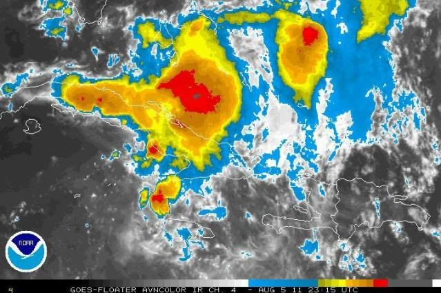
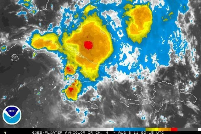
Very high rain-rate a few hours ago.
IMHO, chances look very good for development tonight.
DMAX around sunrise could also add a little kick as well.


IMHO, chances look very good for development tonight.
DMAX around sunrise could also add a little kick as well.
0 likes
-
SouthDadeFish

- Professional-Met

- Posts: 2835
- Joined: Thu Sep 23, 2010 2:54 pm
- Location: Miami, FL
- Contact:
-
cycloneye
- Admin
- Posts: 149431
- Age: 69
- Joined: Thu Oct 10, 2002 10:54 am
- Location: San Juan, Puerto Rico
Re: ATL: Ex EMILY - Models
00z Tracks.

Uploaded by Imageshack.us
Uploaded by Imageshack.us
0 likes
Visit the Caribbean-Central America Weather Thread where you can find at first post web cams,radars
and observations from Caribbean basin members Click Here
and observations from Caribbean basin members Click Here
-
stormreader
Re: Re:
TAD wrote:Nope! I just joined.
I was really surprised when Emily fell apart like that. I read in the news about the flare and then saw it mentioned here... well two synapses got together and I thought maybe there's a correlation.WilmingtonSandbar wrote:one wonders if Gcane and TAD are one and the same?
Well I'm listening because I'm not satisfied with the mountains of DR explanation. I think there's much more to it.
0 likes
-
ozonepete
- Professional-Met
- Posts: 4743
- Joined: Mon Sep 07, 2009 3:23 pm
- Location: From Ozone Park, NYC / Now in Brooklyn, NY
Re: ATL: EMILY - Remnants - Discussion
Two recent IR satellite images. Note how the seabreeze thunderstorms over western Cuba are dying out now. They were never part of the real circulation that's developing from Emily's remnant but they were surely enhanced by the north winds on the western side of the low pressure.
0 likes
Who is online
Users browsing this forum: No registered users and 28 guests