ATL: Ex INVEST 92L - Discussion
Moderator: S2k Moderators
-
floridasun78
- Category 5

- Posts: 3755
- Joined: Sun May 17, 2009 10:16 pm
- Location: miami fl
-
cycloneye

- Admin

- Posts: 149370
- Age: 69
- Joined: Thu Oct 10, 2002 10:54 am
- Location: San Juan, Puerto Rico
Re: ATL: INVEST 92L - Discussion

0 likes
Visit the Caribbean-Central America Weather Thread where you can find at first post web cams,radars
and observations from Caribbean basin members Click Here
and observations from Caribbean basin members Click Here

-
cycloneye
- Admin
- Posts: 149370
- Age: 69
- Joined: Thu Oct 10, 2002 10:54 am
- Location: San Juan, Puerto Rico
Re: ATL: INVEST 92L - Models
Models are being runned again on 92L.

Code: Select all
WHXX01 KWBC 100038
CHGHUR
TROPICAL CYCLONE GUIDANCE MESSAGE
NWS NATIONAL HURRICANE CENTER MIAMI FL
0038 UTC WED AUG 10 2011

DISCLAIMER...NUMERICAL MODELS ARE SUBJECT TO LARGE ERRORS.
PLEASE REFER TO NHC OFFICIAL FORECASTS FOR TROPICAL CYCLONE
AND SUBTROPICAL CYCLONE INFORMATION.

ATLANTIC OBJECTIVE AIDS FOR

DISTURBANCE INVEST (AL922011) 20110809 0000 UTC

        ...00 HRS...   ...12 HRS...   ...24 HRS. ..   ...36 HRS...
        110809  0000   110809  1200   110810  0000   110810  1200

         LAT    LON     LAT    LON     LAT    LON     LAT    LON
BAMS    12.1N  28.5W   12.2N  29.7W   12.2N  31.0W   12.5N  32.5W
BAMD    12.1N  28.5W   12.5N  29.7W   13.2N  31.2W   14.0N  33.0W
BAMM    12.1N  28.5W   12.4N  29.7W   12.8N  31.0W   13.4N  32.8W

        ...48 HRS...   ...72 HRS...   ...96 HRS. ..   ..120 HRS...
        110811  0000   110812  0000   110813  0000   110814  0000

         LAT    LON     LAT    LON     LAT    LON     LAT    LON
BAMS    13.0N  34.1W   14.3N  38.8W   15.9N  45.1W   18.0N  52.0W
BAMD    15.0N  35.2W   17.5N  40.8W   20.1N  46.5W   22.3N  51.2W
BAMM    14.2N  35.0W   16.1N  40.9W   18.2N  47.8W   20.7N  54.2W

         ...INITIAL CONDITIONS...
LATCUR =  12.1N LONCUR =  28.5W DIRCUR = 280DEG SPDCUR =  15KT
LATM12 =  11.6N LONM12 =  25.6W DIRM12 = 281DEG SPDM12 =  14KT
LATM24 =  11.1N LONM24 =  22.6W
WNDCUR =   25KT RMAXWD =   75NM WNDM12 =   25KT
CENPRS = 1010MB OUTPRS = 1012MB OUTRAD =  180NM SDEPTH =   S
RD34NE =    0NM RD34SE =    0NM RD34SW =    0NM RD34NW =   0NM
0 likes
Visit the Caribbean-Central America Weather Thread where you can find at first post web cams,radars
and observations from Caribbean basin members Click Here
and observations from Caribbean basin members Click Here
-
floridasun78
- Category 5
- Posts: 3755
- Joined: Sun May 17, 2009 10:16 pm
- Location: miami fl
-
floridasun78
- Category 5
- Posts: 3755
- Joined: Sun May 17, 2009 10:16 pm
- Location: miami fl
Re: ATL: INVEST 92L - Models
cycloneye wrote:Models are being runned again on 92L.Code: Select all
WHXX01 KWBC 100038
CHGHUR
TROPICAL CYCLONE GUIDANCE MESSAGE
NWS NATIONAL HURRICANE CENTER MIAMI FL
0038 UTC WED AUG 10 2011

DISCLAIMER...NUMERICAL MODELS ARE SUBJECT TO LARGE ERRORS.
PLEASE REFER TO NHC OFFICIAL FORECASTS FOR TROPICAL CYCLONE
AND SUBTROPICAL CYCLONE INFORMATION.

ATLANTIC OBJECTIVE AIDS FOR

DISTURBANCE INVEST (AL922011) 20110809 0000 UTC

        ...00 HRS...   ...12 HRS...   ...24 HRS. ..   ...36 HRS...
        110809  0000   110809  1200   110810  0000   110810  1200

         LAT    LON     LAT    LON     LAT    LON     LAT    LON
BAMS    12.1N  28.5W   12.2N  29.7W   12.2N  31.0W   12.5N  32.5W
BAMD    12.1N  28.5W   12.5N  29.7W   13.2N  31.2W   14.0N  33.0W
BAMM    12.1N  28.5W   12.4N  29.7W   12.8N  31.0W   13.4N  32.8W

        ...48 HRS...   ...72 HRS...   ...96 HRS. ..   ..120 HRS...
        110811  0000   110812  0000   110813  0000   110814  0000

         LAT    LON     LAT    LON     LAT    LON     LAT    LON
BAMS    13.0N  34.1W   14.3N  38.8W   15.9N  45.1W   18.0N  52.0W
BAMD    15.0N  35.2W   17.5N  40.8W   20.1N  46.5W   22.3N  51.2W
BAMM    14.2N  35.0W   16.1N  40.9W   18.2N  47.8W   20.7N  54.2W

         ...INITIAL CONDITIONS...
LATCUR =  12.1N LONCUR =  28.5W DIRCUR = 280DEG SPDCUR =  15KT
LATM12 =  11.6N LONM12 =  25.6W DIRM12 = 281DEG SPDM12 =  14KT
LATM24 =  11.1N LONM24 =  22.6W
WNDCUR =   25KT RMAXWD =   75NM WNDM12 =   25KT
CENPRS = 1010MB OUTPRS = 1012MB OUTRAD =  180NM SDEPTH =   S
RD34NE =    0NM RD34SE =    0NM RD34SW =    0NM RD34NW =   0NM
so the return of 92l
0 likes
-
Florida1118
-
cycloneye
- Admin
- Posts: 149370
- Age: 69
- Joined: Thu Oct 10, 2002 10:54 am
- Location: San Juan, Puerto Rico
Re: ATL: INVEST 92L - Discussion
Florida1118 wrote:It would appear sofloridasun78 wrote:so 92l back?

0 likes
Visit the Caribbean-Central America Weather Thread where you can find at first post web cams,radars
and observations from Caribbean basin members Click Here
and observations from Caribbean basin members Click Here
-
Blown Away

- S2K Supporter

- Posts: 10253
- Joined: Wed May 26, 2004 6:17 am
Re: ATL: INVEST 92L - Models
Macrocane wrote:I'm surprised that nobody has mentioned it yet but now most of the global models are in agreeement about the development of a tropical cyclone in the MDR.
-GFS, FIM and UKMET show a tropical storm developing in about 4 or 5 days. FIM shows landfall in Florida at the end of the run.
-CMC is a little more bullish and develops the system in the nex 2 days.
-NOGAPS keeps it as a well defined low/TD.
-ECMWF is the less bullish and I think it has only a weak reflection.
Or maybe I'm wrong and they are developing another wave, what do you think?
What is the FIM?
0 likes
Hurricane Eye Experience: David 79, Irene 99, Frances 04, Jeanne 04, Wilma 05… Hurricane Brush Experience: Andrew 92, Erin 95, Floyd 99, Matthew 16, Irma 17, Ian 22, Nicole 22…
-
cycloneye
- Admin
- Posts: 149370
- Age: 69
- Joined: Thu Oct 10, 2002 10:54 am
- Location: San Juan, Puerto Rico
Re: ATL: INVEST 92L - Discussion
Latest ASCAT made just before 7 PM EDT.

0 likes
Visit the Caribbean-Central America Weather Thread where you can find at first post web cams,radars
and observations from Caribbean basin members Click Here
and observations from Caribbean basin members Click Here
-
Rgv20

- S2K Supporter
- Posts: 2466
- Age: 39
- Joined: Wed Jan 05, 2011 5:42 pm
- Location: Edinburg/McAllen Tx
Re: ATL: INVEST 92L - Models
Macrocane wrote:I'm surprised that nobody has mentioned it yet but now most of the global models are in agreeement about the development of a tropical cyclone in the MDR.
-GFS, FIM and UKMET show a tropical storm developing in about 4 or 5 days. FIM shows landfall in Florida at the end of the run.
-CMC is a little more bullish and develops the system in the nex 2 days.
-NOGAPS keeps it as a well defined low/TD.
-ECMWF is the less bullish and I think it has only a weak reflection.
Or maybe I'm wrong and they are developing another wave, what do you think?
And also the Global Models now unanimously agree on 92l taking a track NE of the Lesser Antilles and recurving it out to the open Atlantic.
0 likes
The following post is NOT an official forecast and should not be used as such. It is just the opinion of the poster and may or may not be backed by sound meteorological data. It is NOT endorsed by any professional institution including storm2k.org For Official Information please refer to the NHC and NWS products.

Re: ATL: INVEST 92L - Models
FIM is an experimental global model, here's a link: http://fim.noaa.gov/FIMscp/Welcome.cgi?dsKey=fim&domain=244&run_time=09+Aug+2011+-+12Z
I have followed it for 2 weeks only but I like what I've seen so far.
I have followed it for 2 weeks only but I like what I've seen so far.
0 likes


Re: ATL: INVEST 92L - Models
Rgv20 wrote:Macrocane wrote:I'm surprised that nobody has mentioned it yet but now most of the global models are in agreeement about the development of a tropical cyclone in the MDR.
-GFS, FIM and UKMET show a tropical storm developing in about 4 or 5 days. FIM shows landfall in Florida at the end of the run.
-CMC is a little more bullish and develops the system in the nex 2 days.
-NOGAPS keeps it as a well defined low/TD.
-ECMWF is the less bullish and I think it has only a weak reflection.
Or maybe I'm wrong and they are developing another wave, what do you think?
And also the Global Models now unanimously agree on 92l taking a track NE of the Lesser Antilles and recurving it out to the open Atlantic.
I'm not sure about the unanimity of a fish. The FIM and Nogaps dont recurve it early and the CMC is too early to tell. Still, with it over 1500 miles east of land, plenty of time to see how models evolve.
0 likes
-
cycloneye
- Admin
- Posts: 149370
- Age: 69
- Joined: Thu Oct 10, 2002 10:54 am
- Location: San Juan, Puerto Rico
Re: ATL: INVEST 92L - Discussion
Look how much moist air this system has.

0 likes
Visit the Caribbean-Central America Weather Thread where you can find at first post web cams,radars
and observations from Caribbean basin members Click Here
and observations from Caribbean basin members Click Here
-
Windtalker1

- S2K Supporter
- Posts: 523
- Age: 37
- Joined: Sun Jul 31, 2005 11:00 am
- Location: Mesa, Arizona
Re: ATL: INVEST 92L - Discussion
I think we may have our first Major in the makings.
Just my opinion.
The posts in this forum are NOT official forecast and should not be used as such. They are just the opinion of the poster and may or may not be backed by sound meteorological data. They are NOT endorsed by any professional institution or storm2k.org. For official information, please refer to the NHC and NWS products.
0 likes
-
Rgv20
- S2K Supporter
- Posts: 2466
- Age: 39
- Joined: Wed Jan 05, 2011 5:42 pm
- Location: Edinburg/McAllen Tx
0 likes
The following post is NOT an official forecast and should not be used as such. It is just the opinion of the poster and may or may not be backed by sound meteorological data. It is NOT endorsed by any professional institution including storm2k.org For Official Information please refer to the NHC and NWS products.
-
HurricaneWarning92
- Category 2

- Posts: 520
- Joined: Sat Jul 23, 2011 4:33 pm
- Location: Pembroke Pines, S. Florida (Lat: 26.00N, Lon: 80.22W)
Re:
Rgv20 wrote::uarrow: oh I think the Forecast models would eventually correct themselves west with future runs. Its going to be interesting to see how much latitude it gains when it reaches 55W.
How so? will a ridge be building in westwards, not allowing it to recurve?
0 likes
The posts in this forum are NOT official forecast and should not be used as such. They are just the opinion of the poster and may or may not be backed by sound meteorological data. They are NOT endorsed by any professional institution or storm2k.org. For official information, please refer to the NHC and NWS products.
-
HurricaneWarning92
- Category 2
- Posts: 520
- Joined: Sat Jul 23, 2011 4:33 pm
- Location: Pembroke Pines, S. Florida (Lat: 26.00N, Lon: 80.22W)
Re: ATL: INVEST 92L - Discussion
cycloneye wrote:Look how much moist air this system has.
dang.. the rotation on this system is impressive...
0 likes
The posts in this forum are NOT official forecast and should not be used as such. They are just the opinion of the poster and may or may not be backed by sound meteorological data. They are NOT endorsed by any professional institution or storm2k.org. For official information, please refer to the NHC and NWS products.
-
Rgv20
- S2K Supporter
- Posts: 2466
- Age: 39
- Joined: Wed Jan 05, 2011 5:42 pm
- Location: Edinburg/McAllen Tx
Re: Re:
HurricaneWarning92 wrote:Rgv20 wrote::uarrow: oh I think the Forecast models would eventually correct themselves west with future runs. Its going to be interesting to see how much latitude it gains when it reaches 55W.
How so? will a ridge be building in westwards, not allowing it to recurve?
Looking at the 12zECMWF and GFS forecast 500mb heights the trough on the east coast is weakening from 8 thru 10 days and being replace by a ridge in south eastern canada represented by the light orange colors on the map. This could potentially but the east coast at risk if 92l were to develop and track to the south west Atlantic.
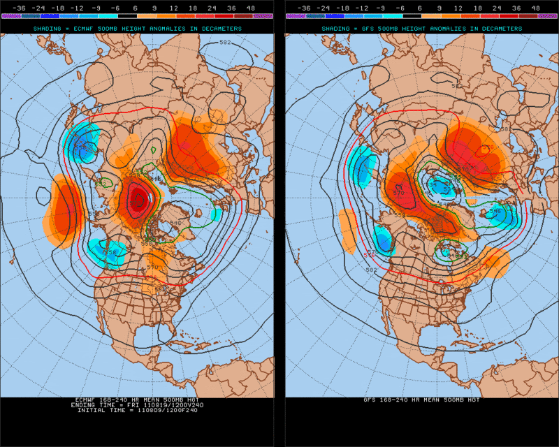
Of course it is still way too early to forecast where 92l will track, just have to keep all options open at this point.
0 likes
The following post is NOT an official forecast and should not be used as such. It is just the opinion of the poster and may or may not be backed by sound meteorological data. It is NOT endorsed by any professional institution including storm2k.org For Official Information please refer to the NHC and NWS products.
Who is online
Users browsing this forum: No registered users and 25 guests