ATL : HARVEY - Tropical Depression - Discussion
Moderator: S2k Moderators


Re: ATL: Ex INVEST 93L - Models
I was going to say that, Are you being sarcastic Rock?  Or am I missing something?
0 likes
-
Kory
- Tropical Storm

- Posts: 200
- Age: 30
- Joined: Tue Aug 02, 2011 11:32 am
- Location: New Orleans, Louisiana
Re:
BigB0882 wrote:I don't see much on those maps. Is it at the very bottom of the BOC? Doesn't look like much to me and the moisture it brings, which is better than nothing, looks minimal and I seriously doubt would be so wide spread.
Yes the map shows an open wave in the Bay of Campeche...nothing to get too excited about. May bring a little more moisture to Texas.
0 likes
-
cycloneye

- Admin

- Posts: 149374
- Age: 69
- Joined: Thu Oct 10, 2002 10:54 am
- Location: San Juan, Puerto Rico
Re: ATL: Ex INVEST 93L - Models
Macrocane wrote:I was going to say that, Are you being sarcastic Rock?
He was sarcastic.
0 likes
Visit the Caribbean-Central America Weather Thread where you can find at first post web cams,radars
and observations from Caribbean basin members Click Here
and observations from Caribbean basin members Click Here

Re: ATL: Ex INVEST 93L - Models
Macrocane wrote:I was going to say that, Are you being sarcastic Rock?
sarcastic... this site was jacked... showing both yesterdays and todays run...
TW in the BOC is the right call
0 likes
Re: ATL: Ex INVEST 93L - Models
12Z NOGAPS looks like a good call and follows the GFS....
https://www.fnmoc.navy.mil/wxmap_cgi/cg ... t=Tropical
https://www.fnmoc.navy.mil/wxmap_cgi/cg ... t=Tropical
0 likes
Re: ATL: Ex INVEST 93L - Models
12Z GFDL for 92L slams 93L into CA.....never really closes it off....
about time for me to mossy on over to the TT forum and the global discussion thread....
about time for me to mossy on over to the TT forum and the global discussion thread....
0 likes
-
Rgv20

- S2K Supporter

- Posts: 2466
- Age: 39
- Joined: Wed Jan 05, 2011 5:42 pm
- Location: Edinburg/McAllen Tx
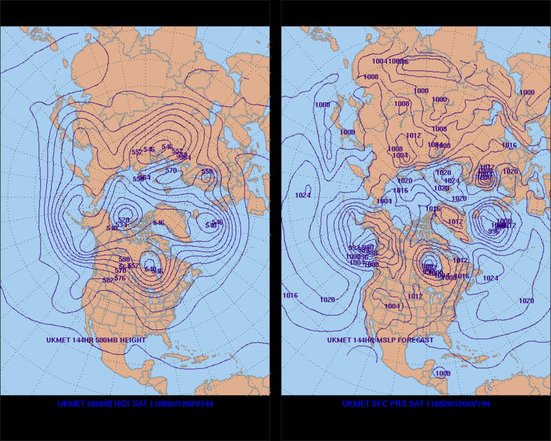
12zUKEMT develops 93L once it crosses 75W on Thursday and by day 6 Saturday (Aug 20) its east of the Yucatan.
0 likes
The following post is NOT an official forecast and should not be used as such. It is just the opinion of the poster and may or may not be backed by sound meteorological data. It is NOT endorsed by any professional institution including storm2k.org For Official Information please refer to the NHC and NWS products.
-
Rgv20
- S2K Supporter
- Posts: 2466
- Age: 39
- Joined: Wed Jan 05, 2011 5:42 pm
- Location: Edinburg/McAllen Tx
In my Opinion, 93L is going to try to develop when it reaches 75W on Thursday as the 12zUKMET is suggesting and as far as track I think the GFS&ECMWF are too far south. My thinking is that this morning UKMET run is very believable in showing a closed low east of the Yucatan Peninsula this coming Saturday.
0 likes
The following post is NOT an official forecast and should not be used as such. It is just the opinion of the poster and may or may not be backed by sound meteorological data. It is NOT endorsed by any professional institution including storm2k.org For Official Information please refer to the NHC and NWS products.

Re: ATL : Ex INVEST 93L - Discussion
looks real dry in the eastern Caribbean on the water vapor imagery loop. They moved the mid level moisture map so I don't know if things are any better closer to the surface. Once 93L enters the Caribbean there will probably be the usual shear to deal with as well. Over near Jamaica conditions could improve but by then the "death ridge" over Texas would probably keep it on a western track into Mexico.
0 likes
-
Extratropical94

- Professional-Met

- Posts: 3545
- Age: 31
- Joined: Wed Oct 20, 2010 6:36 am
- Location: Hamburg, Germany
- Contact:
Maybe a Matthew '10 like system, both track and intensity wise? Remember how he was predicted to become a cane, but struggled and "only" intensified to 60 mph.


0 likes
54° 11' 59'' N, 9° 9' 20'' E
Boomer Sooner!
Go Broncos! Go Cards!
Clinching counties, one at a time: https://mob-rule.com/user-gifs/USA/xtrp94.gif
- Daniel
Boomer Sooner!
Go Broncos! Go Cards!
Clinching counties, one at a time: https://mob-rule.com/user-gifs/USA/xtrp94.gif
- Daniel
-
northtxboy

- Category 1

- Posts: 262
- Age: 44
- Joined: Mon Jan 03, 2011 1:50 pm
- Location: Windom Tx
- Contact:


-
Portastorm

- Storm2k Moderator

- Posts: 9955
- Age: 63
- Joined: Fri Jul 11, 2003 9:16 am
- Location: Round Rock, TX
- Contact:
Re: ATL : Ex INVEST 93L - Discussion
Surprisingly, there's still a fair amount of vorticity to it based on this satellite image.
http://www.ssd.noaa.gov/goes/east/catl/flash-avn.html
http://www.ssd.noaa.gov/goes/east/catl/flash-avn.html
0 likes
Any forecasts under my name are to be taken with a grain of salt. Get your best forecasts from the National Weather Service and National Hurricane Center.
-
cycloneye
- Admin
- Posts: 149374
- Age: 69
- Joined: Thu Oct 10, 2002 10:54 am
- Location: San Juan, Puerto Rico
Re: ATL : Ex INVEST 93L - Discussion
Portastorm wrote:Surprisingly, there's still a fair amount of vorticity to it based on this satellite image.
http://www.ssd.noaa.gov/goes/east/catl/flash-avn.html
If that trend continues,we may see 93L reactivated fairly soon.
0 likes
Visit the Caribbean-Central America Weather Thread where you can find at first post web cams,radars
and observations from Caribbean basin members Click Here
and observations from Caribbean basin members Click Here

Re: ATL: Ex INVEST 93L - Models
What does CA mean? Everytime I see it I'm thinking you guys are saying it's crossing Mexico and slamming in California.
0 likes
-
cycloneye
- Admin
- Posts: 149374
- Age: 69
- Joined: Thu Oct 10, 2002 10:54 am
- Location: San Juan, Puerto Rico
Re: ATL: Ex INVEST 93L - Models
Duddy wrote:What does CA mean? Everytime I see it I'm thinking you guys are saying it's crossing Mexico and slamming in California.
CA means Central America.
0 likes
Visit the Caribbean-Central America Weather Thread where you can find at first post web cams,radars
and observations from Caribbean basin members Click Here
and observations from Caribbean basin members Click Here
-
jlauderdal
- S2K Supporter
- Posts: 7240
- Joined: Wed May 19, 2004 5:46 am
- Location: NE Fort Lauderdale
- Contact:
Re: ATL: Ex INVEST 93L - Models
Duddy wrote:What does CA mean? Everytime I see it I'm thinking you guys are saying it's crossing Mexico and slamming in California.
central america
0 likes
Re: ATL: Ex INVEST 93L - Models
http://www.nco.ncep.noaa.gov/pmb/nwprod ... p_084l.gif
NAM- 84hr
still does not bite on the CA theory....the EURO still seems bent on sending this into CA...looking more and more likely unless this developes quickly...
NAM- 84hr
still does not bite on the CA theory....the EURO still seems bent on sending this into CA...looking more and more likely unless this developes quickly...
0 likes
Re: ATL : Ex INVEST 93L - Discussion
http://tropic.ssec.wisc.edu/real-time/w ... oom=&time=
still some kick in this mule...maybe but it did this yesterday...also...
still some kick in this mule...maybe but it did this yesterday...also...
0 likes
-
lonelymike
- S2K Supporter
- Posts: 634
- Joined: Sat Jul 26, 2008 10:12 am
- Location: walton county fla
Re:
northtxboy wrote:I still think we are looking at a U.S lanfall with this system. Just my thoughts doesnt mean it will hapeen but there is a good chance for it.
Please dazzle with your meterological logic about why you think a US landfall is possible?
0 likes
GO SEMINOLES
Who is online
Users browsing this forum: No registered users and 8 guests