Pouch P17L in Eastern Atlantic -(Now Invest 97L)
Moderator: S2k Moderators
Forum rules

The posts in this forum are NOT official forecasts and should not be used as such. They are just the opinion of the poster and may or may not be backed by sound meteorological data. They are NOT endorsed by any professional institution or STORM2K. For official information, please refer to products from the National Hurricane Center and National Weather Service.
-
Rgv20

- S2K Supporter

- Posts: 2466
- Age: 39
- Joined: Wed Jan 05, 2011 5:42 pm
- Location: Edinburg/McAllen Tx
0 likes
The following post is NOT an official forecast and should not be used as such. It is just the opinion of the poster and may or may not be backed by sound meteorological data. It is NOT endorsed by any professional institution including storm2k.org For Official Information please refer to the NHC and NWS products.
-
Miami Storm Tracker

- Category 4

- Posts: 916
- Age: 68
- Joined: Sun Jun 13, 2010 10:12 pm
- Location: Key Largo, Fla.
- Contact:
Re: Pouch P17L in Eastern Atlantic - 10%
Ivanhater wrote:Here is the 12z FIM model.

Michael,
Was the last run you posted in anyway trying to reply to my question about the western extent of the high? And it going accross the middle or lower keys.
0 likes


Re: Pouch P17L in Eastern Atlantic - 10%
Does anyone have the 12z CMC long range? I did not see it today. Thanks
0 likes
The following post is NOT an official forecast and should not be used as such. It is just the opinion of the poster and may or may not be backed by sound meteorological data. It is NOT endorsed by any professional institution including storm2k.org For Official Information please refer to the NHC and NWS products.
-
Blown Away

- S2K Supporter
- Posts: 10253
- Joined: Wed May 26, 2004 6:17 am
Re:
Catastrophic global model landfalls, 10% development, nice cyclonic spin, limited but persistent convection, and heavy Storm2k activity, what's it take to get an invest tag? Geeez!!!
0 likes
Hurricane Eye Experience: David 79, Irene 99, Frances 04, Jeanne 04, Wilma 05… Hurricane Brush Experience: Andrew 92, Erin 95, Floyd 99, Matthew 16, Irma 17, Ian 22, Nicole 22…
-
Ivanhater

- Storm2k Moderator

- Posts: 11221
- Age: 39
- Joined: Fri Jul 01, 2005 8:25 am
- Location: Pensacola
Re: Pouch P17L in Eastern Atlantic - 10%
Miami Storm Tracker wrote:Ivanhater wrote:Here is the 12z FIM model.
Michael,
Was the last run you posted in anyway trying to reply to my question about the western extent of the high? And it going accross the middle or lower keys.
The ridge placement in the image you are talking about looks worrisome for South Florida.
0 likes
Michael
-
Ivanhater
- Storm2k Moderator
- Posts: 11221
- Age: 39
- Joined: Fri Jul 01, 2005 8:25 am
- Location: Pensacola
Re: Pouch P17L in Eastern Atlantic - 10%
blp wrote:Does anyone have the 12z CMC long range? I did not see it today. Thanks
Here ya go

0 likes
Michael
-
Rgv20
- S2K Supporter
- Posts: 2466
- Age: 39
- Joined: Wed Jan 05, 2011 5:42 pm
- Location: Edinburg/McAllen Tx
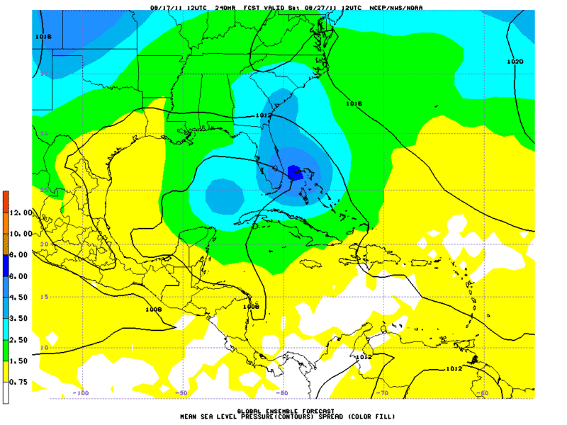
Took a closer look at the long range GFS&Euro Ensembles and the Operational 12zECMWF favors a more westward track, its ensembles favor a track just east of Florida. It seems the GFS ensembles are split regarding the track with most showing a track closer toward south florida and a few out in the central GOM.
12zECMWF Ensembles valid for Saturday August 27. As you can see represented by the dark purple shadings almost all of the ensembles members are well east with their track than the operational run.
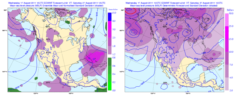
12zGFS Ensembles valid for Saturday August 27. The potential tracks are closer to south florida with a few of them in the Central GOM.
12zECMWF Ensembles valid for Saturday August 27. As you can see represented by the dark purple shadings almost all of the ensembles members are well east with their track than the operational run.
12zGFS Ensembles valid for Saturday August 27. The potential tracks are closer to south florida with a few of them in the Central GOM.
Last edited by Rgv20 on Wed Aug 17, 2011 8:52 pm, edited 1 time in total.
0 likes
The following post is NOT an official forecast and should not be used as such. It is just the opinion of the poster and may or may not be backed by sound meteorological data. It is NOT endorsed by any professional institution including storm2k.org For Official Information please refer to the NHC and NWS products.
-
Miami Storm Tracker
- Category 4
- Posts: 916
- Age: 68
- Joined: Sun Jun 13, 2010 10:12 pm
- Location: Key Largo, Fla.
- Contact:
Re: Pouch P17L in Eastern Atlantic - 10%
Ivanhater wrote:Miami Storm Tracker wrote:Ivanhater wrote:Here is the 12z FIM model.
Michael,
Was the last run you posted in anyway trying to reply to my question about the western extent of the high? And it going accross the middle or lower keys.
The ridge placement in the image you are talking about looks worrisome for South Florida.
Thank you for the reply, guess i was assuming based on how I read the bars that it extended accrosses the middle keys which would maybe allow it to get further west. Based on your response south mia and south florida not looking good.
0 likes

-
lonelymike
- S2K Supporter
- Posts: 634
- Joined: Sat Jul 26, 2008 10:12 am
- Location: walton county fla
Re: Pouch P17L in Eastern Atlantic - 10%
Thanks RG and Michael for taking the time to post all the runs 10 days out so plenty of time to watch....and pray 
0 likes
GO SEMINOLES
Re: Pouch P17L in Eastern Atlantic - 10%
Ivanhater wrote:blp wrote:Does anyone have the 12z CMC long range? I did not see it today. Thanks
Here ya go
Thanks, do you have the grayscale maps that go out to 240hr.
0 likes
The following post is NOT an official forecast and should not be used as such. It is just the opinion of the poster and may or may not be backed by sound meteorological data. It is NOT endorsed by any professional institution including storm2k.org For Official Information please refer to the NHC and NWS products.
Re: Pouch P17L in Eastern Atlantic - 10%
18z HWRF on 93L picking up on our system south of Hispaniola.

0 likes
The following post is NOT an official forecast and should not be used as such. It is just the opinion of the poster and may or may not be backed by sound meteorological data. It is NOT endorsed by any professional institution including storm2k.org For Official Information please refer to the NHC and NWS products.
-
gatorcane

- S2K Supporter
- Posts: 23708
- Age: 48
- Joined: Sun Mar 13, 2005 3:54 pm
- Location: Boca Raton, FL
DGEX model 18z shows it approaching SE Florida at 192 hours. Needless to say that is a long way out thankfully.
http://www.emc.ncep.noaa.gov/mmb/mmbpll/dgexops.conus
http://www.emc.ncep.noaa.gov/mmb/mmbpll/dgexops.conus
0 likes
-
lonelymike
- S2K Supporter
- Posts: 634
- Joined: Sat Jul 26, 2008 10:12 am
- Location: walton county fla
Re: Pouch P17L in Eastern Atlantic - 10%
blp wrote:18z HWRF on 93L picking up on our system south of Hispaniola.
For entertainment purposes only

0 likes
GO SEMINOLES
-
Miami Storm Tracker
- Category 4
- Posts: 916
- Age: 68
- Joined: Sun Jun 13, 2010 10:12 pm
- Location: Key Largo, Fla.
- Contact:
Re: Pouch P17L in Eastern Atlantic - 10%
Gator,
What is the DGEX model is it run off of another model using similar data.
What is the DGEX model is it run off of another model using similar data.
0 likes
-
gatorcane
- S2K Supporter
- Posts: 23708
- Age: 48
- Joined: Sun Mar 13, 2005 3:54 pm
- Location: Boca Raton, FL
Re: Pouch P17L in Eastern Atlantic - 10%
Miami Storm Tracker wrote:Gator,
What is the DGEX model is it run off of another model using similar data.
Website states:
"These are plots of the 84-192 h forecasts from the Downscaled GFS by NAM Extension (DGEX) and the operational GFS."
0 likes
-
Miami Storm Tracker
- Category 4
- Posts: 916
- Age: 68
- Joined: Sun Jun 13, 2010 10:12 pm
- Location: Key Largo, Fla.
- Contact:
Re: Pouch P17L in Eastern Atlantic - 10%
Thank you,
for clarifying that seems most models keep it on a general track this way.
for clarifying that seems most models keep it on a general track this way.
0 likes
-
cycloneye

- Admin

- Posts: 149389
- Age: 69
- Joined: Thu Oct 10, 2002 10:54 am
- Location: San Juan, Puerto Rico
Re: Pouch P17L in Eastern Atlantic - 10%
ASCAT pass made at 8 PM EDT. It missed part of the circulation,but still you can see how the arrow directions are.

0 likes
Visit the Caribbean-Central America Weather Thread where you can find at first post web cams,radars
and observations from Caribbean basin members Click Here
and observations from Caribbean basin members Click Here
-
stormhunter7

- Category 2

- Posts: 763
- Joined: Mon May 26, 2008 3:13 pm
- Location: Panama City Beach, Florida
- Contact:
Re: Pouch P17L in Eastern Atlantic - 10%
up to 2009 and all the models that were used up until then... Enjoy 
http://www.nhc.noaa.gov/pdf/model_summary_20090724.pdf
http://www.nhc.noaa.gov/pdf/model_summary_20090724.pdf
0 likes
The following post is NOT an official forecast and should not be used as such. It is just the opinion of the poster and may or may not be backed by sound meteorological data. It is NOT endorsed by any professional institution including storm2k.org For Official Information please refer to the NHC and NWS products. http://www.nhc.noaa.gov
Who is online
Users browsing this forum: No registered users and 57 guests