ATL: IRENE - Models

Moderator: S2k Moderators

Message
Author
wjs3
S2K Supporter
S2K Supporter
Posts: 633
Joined: Sat Aug 14, 2004 7:57 am

Re:

#4241 Postby wjs3 » Mon Aug 22, 2011 11:27 pm

ConvergenceZone wrote:Can anyone tell if the GFS has Irene making landfall? it's so difficult to tell because it's so strong and the white is covering up the coastline, lol...


Yep, makes landfall in North Carolina.
0 likes   

User avatar
chris_fit
Category 5
Category 5
Posts: 3222
Age: 42
Joined: Wed Sep 10, 2003 11:58 pm
Location: Tampa Bay Area, FL

#4242 Postby chris_fit » Mon Aug 22, 2011 11:27 pm

150

Image

Uploaded with ImageShack.us
0 likes   

User avatar
PTrackerLA
Category 5
Category 5
Posts: 5277
Age: 41
Joined: Thu Oct 10, 2002 8:40 pm
Location: Lafayette, LA

#4243 Postby PTrackerLA » Mon Aug 22, 2011 11:27 pm

Wow look out northeast on this run :eek: . First hurricane hit in 20 years?
Last edited by PTrackerLA on Mon Aug 22, 2011 11:29 pm, edited 1 time in total.
0 likes   

Ev1948
S2K Supporter
S2K Supporter
Posts: 65
Joined: Mon Jun 28, 2010 6:16 pm
Location: Florida USA -from South New Jersey

Re: ATL: IRENE - Models

#4244 Postby Ev1948 » Mon Aug 22, 2011 11:28 pm

I come here to look at the models( I don't know what I am looking at) but somehow it helps me to understand, I read all that you are saying, I want to thank all of you in what you do keeping us informed, it helps to get through these storms, for me anyway, so many of you work so hard to keep us updated. Just Thank You ! :D

Evelyn
0 likes   

User avatar
SouthFLTropics
Category 5
Category 5
Posts: 4236
Age: 50
Joined: Thu Aug 14, 2003 8:04 am
Location: Port St. Lucie, Florida

Re: ATL: IRENE - Models

#4245 Postby SouthFLTropics » Mon Aug 22, 2011 11:29 pm

Battlebrick wrote:i can only imagine the rain totals for the whole eastern seaboard for the 0z GFS..


Too bad we can't bottle it all up and send it to Texas. Would you like some fresh bottled Irene water Rock???

SFT
0 likes   
Fourth Generation Florida Native

Personal Storm History: David 79, Andrew 92, Erin 95, Floyd 99, Irene 99, Frances 04, Jeanne 04, Wilma 05, Matthew 16, Irma 17, Ian 22, Nicole 22, Milton 24

User avatar
Hybridstorm_November2001
S2K Supporter
S2K Supporter
Posts: 2811
Joined: Sat Aug 21, 2004 2:50 pm
Location: SW New Brunswick, Canada
Contact:

Re:

#4246 Postby Hybridstorm_November2001 » Mon Aug 22, 2011 11:29 pm

chris_fit wrote:150

Image

Uploaded with ImageShack.us


Crap, there goes Long Island. :double:
0 likes   

User avatar
SouthFloridawx
S2K Supporter
S2K Supporter
Posts: 8346
Age: 46
Joined: Tue Jul 26, 2005 1:16 am
Location: Sarasota, FL
Contact:

Re: ATL: IRENE - Models

#4247 Postby SouthFloridawx » Mon Aug 22, 2011 11:30 pm

Wow, what a storm this is going to be.
0 likes   

wjs3
S2K Supporter
S2K Supporter
Posts: 633
Joined: Sat Aug 14, 2004 7:57 am

Re:

#4248 Postby wjs3 » Mon Aug 22, 2011 11:30 pm

PTrackerLA wrote:Wow look out northeast on this run :eek: .


Yeah--it JUST misses the trough and then just enough ridging builds in to keep it pinned against the seaboard the whole way. It would be really something.
0 likes   

User avatar
Listeri69
Tropical Low
Tropical Low
Posts: 24
Age: 47
Joined: Wed Sep 01, 2010 3:08 pm
Location: Meriden CT

Re: ATL: IRENE - Models

#4249 Postby Listeri69 » Mon Aug 22, 2011 11:30 pm

Looks like this one is heading straight for us in CT :eek: 150hrs is some time away should I be worried yet?
0 likes   
Scotland the only place where you can get a suntan and trench foot on the same day :)

maxintensity
Tropical Storm
Tropical Storm
Posts: 165
Joined: Tue Aug 02, 2011 9:54 pm

Re: ATL: IRENE - Models

#4250 Postby maxintensity » Mon Aug 22, 2011 11:30 pm

Irene poised to become a media sensation on that track. Remains likely to rival katrina if it takes that path.
0 likes   

User avatar
SouthFloridawx
S2K Supporter
S2K Supporter
Posts: 8346
Age: 46
Joined: Tue Jul 26, 2005 1:16 am
Location: Sarasota, FL
Contact:

Re: ATL: IRENE - Models

#4251 Postby SouthFloridawx » Mon Aug 22, 2011 11:31 pm

Up to 14 states affected.
0 likes   

User avatar
SouthFLTropics
Category 5
Category 5
Posts: 4236
Age: 50
Joined: Thu Aug 14, 2003 8:04 am
Location: Port St. Lucie, Florida

Re: ATL: IRENE - Models

#4252 Postby SouthFLTropics » Mon Aug 22, 2011 11:31 pm

:uarrow: EPIC!!! If this holds true the media is going to be in a frenzy!!! I don't think I've ever seen Cantore broadcast from Times Square before???
0 likes   
Fourth Generation Florida Native

Personal Storm History: David 79, Andrew 92, Erin 95, Floyd 99, Irene 99, Frances 04, Jeanne 04, Wilma 05, Matthew 16, Irma 17, Ian 22, Nicole 22, Milton 24

User avatar
chris_fit
Category 5
Category 5
Posts: 3222
Age: 42
Joined: Wed Sep 10, 2003 11:58 pm
Location: Tampa Bay Area, FL

#4253 Postby chris_fit » Mon Aug 22, 2011 11:31 pm

Last one... 162


Image

Uploaded with ImageShack.us


Think I'm going to bed... FL looks good to me! Will send some thoughts to our neighbors up north!
Last edited by chris_fit on Mon Aug 22, 2011 11:31 pm, edited 1 time in total.
0 likes   

wjs3
S2K Supporter
S2K Supporter
Posts: 633
Joined: Sat Aug 14, 2004 7:57 am

Re: ATL: IRENE - Models

#4254 Postby wjs3 » Mon Aug 22, 2011 11:31 pm

Listeri69 wrote:Looks like this one is heading straight for us in CT :eek: 150hrs is some time away should I be worried yet?


Be prepared. Never know. Almost a week away. A lot can change, or not.
0 likes   

User avatar
SouthFloridawx
S2K Supporter
S2K Supporter
Posts: 8346
Age: 46
Joined: Tue Jul 26, 2005 1:16 am
Location: Sarasota, FL
Contact:

Re: ATL: IRENE - Models

#4255 Postby SouthFloridawx » Mon Aug 22, 2011 11:32 pm

Look out Canada too!
0 likes   

wjs3
S2K Supporter
S2K Supporter
Posts: 633
Joined: Sat Aug 14, 2004 7:57 am

Re:

#4256 Postby wjs3 » Mon Aug 22, 2011 11:32 pm

chris_fit wrote:Last one... 162


Image

Uploaded with ImageShack.us


Think I'm going to bed... FL looks good to me! Will send some thoughts to our neighbors up north!


Awesome work. Thank you!
0 likes   

JTD
Category 5
Category 5
Posts: 1558
Joined: Sun Nov 02, 2003 6:35 pm

Re: ATL: IRENE - Models

#4257 Postby JTD » Mon Aug 22, 2011 11:32 pm

2nd run in a row of the GFS to show a NYC hit. A 2-3 hitting NYC is the ultimate nightmare scenario, 10 x worse than Katrina. See Derek Ortt's posts on S2K on the subject written years ago.
Last edited by JTD on Mon Aug 22, 2011 11:34 pm, edited 1 time in total.
0 likes   

maxintensity
Tropical Storm
Tropical Storm
Posts: 165
Joined: Tue Aug 02, 2011 9:54 pm

Re: ATL: IRENE - Models

#4258 Postby maxintensity » Mon Aug 22, 2011 11:33 pm

SouthFLTropics wrote::uarrow: EPIC!!! If this holds true the media is going to be in a frenzy!!! I don't think I've ever seen Cantore broadcast from Times Square before???
times square is the crossroads of the world. That would be epic :lol:
0 likes   

User avatar
PTrackerLA
Category 5
Category 5
Posts: 5277
Age: 41
Joined: Thu Oct 10, 2002 8:40 pm
Location: Lafayette, LA

#4259 Postby PTrackerLA » Mon Aug 22, 2011 11:33 pm

This will become a HUGE news story tomorrow if the Euro shows a similar solution. Very well may be one for the history books here, so many millions directly impacted.
0 likes   

User avatar
WxGuy1
Professional-Met
Professional-Met
Posts: 538
Joined: Sat Oct 22, 2005 12:55 pm
Location: Oklahoma

#4260 Postby WxGuy1 » Mon Aug 22, 2011 11:34 pm

I wouldn't get too hung up on small details right now. Granted, small details may make a very significant impact on the effects that any given may experience, but we're still talking about a 5 day forecast on a strengthening (in the medium term, at least) hurricane that's going to recurve (probably not out to sea, but it's path will certainly turn clockwise with time). As I'm sure some of us know, there angle of approach may be very acute in this case, so minor fluctuations in the heading of the hurricane by day 5 may end up moving the landfall location hundreds of miles one way or another. I know it's occassionally fun to do play-by-play, fretting over every new graphic that comes out for every new model and new run, but it's probably not worth the added stress right now if you are living along the coast between Florida and Maine. It's easy for me to say that sitting in the middle of the continent, but it's true. Keep an eye on the models, begin to think about preliminary plans, but don't get too caught up on the minor trends or differences in a particular model and model run.

The trend over many models and many runs has certainly been eastward. You can see that in this loop of all GFS forecasts valid Friday morning --> CLICK HERE.

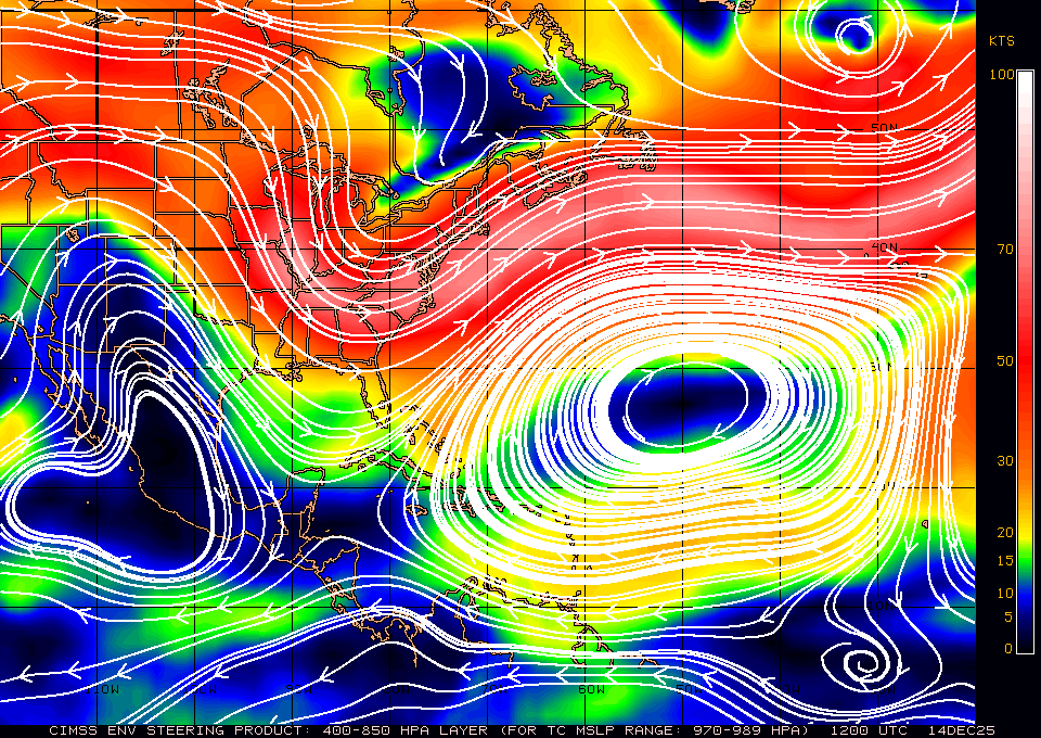
Also, for those who may not follow tropical weather frequently, please remember that, when we speak of "ridges" or "ridging" in reference to steering currents (e.g. where will the tropical cyclone go?), you'll want to look at 300-500 mb height maps (for hurricanes) or 500-700 mb height maps (for weaker tropical cyclones). The loop I linked to above shows the surface pressure, which doesn't particularly affect the motion of a strong tropical cyclone like Irene. See THIS LINK for current steering analysis using 400-850 mb winds, or click the 250-850 mb link at the top of that page (which will be more representative of the steering currents pretty soon as Irene continues to deepen).
Image

There's also a nice example of a col to the NW of Irene right now. The axis of dilation lies NW-SE to the northwest of Irene.
Last edited by WxGuy1 on Mon Aug 22, 2011 11:34 pm, edited 1 time in total.
0 likes   


Return to “2011”

Who is online

Users browsing this forum: No registered users and 31 guests