Global model runs discussion

Moderator: S2k Moderators

Message
Author
User avatar
LaBreeze
Category 5
Category 5
Posts: 1497
Joined: Thu Sep 04, 2003 1:57 pm
Location: SW Louisiana

Re:

#2621 Postby LaBreeze » Sat Aug 27, 2011 1:34 am

HurricaneWarning92 wrote:does it recurve or could it be a threat to the east coast?... interesting.


Probably recurve is my guess.
0 likes   

User avatar
cycloneye
Admin
Admin
Posts: 145275
Age: 68
Joined: Thu Oct 10, 2002 10:54 am
Location: San Juan, Puerto Rico

Re: Global Model Runs Discussion

#2622 Postby cycloneye » Sat Aug 27, 2011 5:33 am

Surprised nobody posted the 00z ECMWF.

Image
0 likes   
Visit the Caribbean-Central America Weather Thread where you can find at first post web cams,radars
and observations from Caribbean basin members Click Here

rockyman
Category 5
Category 5
Posts: 1967
Joined: Thu Jun 26, 2003 12:24 pm
Location: Dauphin Island, AL

Global Model Runs Discussion

#2623 Postby rockyman » Sat Aug 27, 2011 8:20 am

The Euro still SLOWLY develops an area of low pressure down in the Bay of Campeche, moving toward the north central Gulf by Day 10. The system should be festering in the BOC this weekend
0 likes   

HurricaneWarning92
Category 2
Category 2
Posts: 520
Joined: Sat Jul 23, 2011 4:33 pm
Location: Pembroke Pines, S. Florida (Lat: 26.00N, Lon: 80.22W)

Re: Global Model Runs Discussion

#2624 Postby HurricaneWarning92 » Sat Aug 27, 2011 8:23 am

cycloneye wrote:Surprised nobody posted the 00z ECMWF.

Image


is it me or run after run, both the ECMWF and GFS have it closer to the U.S?
0 likes   
The posts in this forum are NOT official forecast and should not be used as such. They are just the opinion of the poster and may or may not be backed by sound meteorological data. They are NOT endorsed by any professional institution or storm2k.org. For official information, please refer to the NHC and NWS products.

User avatar
Macrocane
Category 5
Category 5
Posts: 4218
Age: 36
Joined: Sun May 24, 2009 5:35 pm
Location: El Salvador

Re: Global Model Runs Discussion

#2625 Postby Macrocane » Sat Aug 27, 2011 9:01 am

FIMY 0z is much more east with the Atlantic system but it also has a tropical cyclone in the GOM at 240 hours although more west than the Euro system:

Image
0 likes   

User avatar
CourierPR
Category 5
Category 5
Posts: 1335
Age: 71
Joined: Tue Aug 31, 2004 7:53 pm
Location: Pompano Beach, Florida

Re: Global Model Runs Discussion

#2626 Postby CourierPR » Sat Aug 27, 2011 9:08 am

HurricaneWarning92 wrote:
cycloneye wrote:Surprised nobody posted the 00z ECMWF.

http://www.ecmwf.int/products/forecasts ... !chart.gif[]


is it me or run after run, both the ECMWF and GFS have it closer to the U.S?


Bastardi tweets that this system is the next east coast threat.
0 likes   

HurricaneWarning92
Category 2
Category 2
Posts: 520
Joined: Sat Jul 23, 2011 4:33 pm
Location: Pembroke Pines, S. Florida (Lat: 26.00N, Lon: 80.22W)

#2627 Postby HurricaneWarning92 » Sat Aug 27, 2011 9:24 am

Well thats interesting cause the models have it as a recurve right now.
0 likes   
The posts in this forum are NOT official forecast and should not be used as such. They are just the opinion of the poster and may or may not be backed by sound meteorological data. They are NOT endorsed by any professional institution or storm2k.org. For official information, please refer to the NHC and NWS products.

User avatar
Jevo
S2K Supporter
S2K Supporter
Posts: 1729
Age: 47
Joined: Tue Aug 03, 2004 8:45 pm
Location: The Flemish Cap
Contact:

#2628 Postby Jevo » Sat Aug 27, 2011 9:29 am

8 days out on the Euro

Image

Uploaded with ImageShack.us
0 likes   
Disclaimer: 50% of the time I have no clue of what I am talking about. Chances are I am taking a less than educated guess that sounds good because 10 years ago I stole Mike Watkins book 'The Hurricane and its Impact'. For official information please direct yourself to the NHC and their cadre of weather geniuses.

RL3AO
Moderator-Pro Met
Moderator-Pro Met
Posts: 16308
Joined: Thu Jun 14, 2007 10:03 pm
Location: NC

#2629 Postby RL3AO » Sat Aug 27, 2011 9:47 am

Is this pouch 21L (just off the African coast)?
0 likes   

User avatar
cycloneye
Admin
Admin
Posts: 145275
Age: 68
Joined: Thu Oct 10, 2002 10:54 am
Location: San Juan, Puerto Rico

Re:

#2630 Postby cycloneye » Sat Aug 27, 2011 9:55 am

RL3AO wrote:Is this pouch 21L (just off the African coast)?


Yes is that one.
0 likes   
Visit the Caribbean-Central America Weather Thread where you can find at first post web cams,radars
and observations from Caribbean basin members Click Here

Adoquín
Tropical Storm
Tropical Storm
Posts: 140
Joined: Thu Jul 28, 2011 8:47 pm

Re:

#2631 Postby Adoquín » Sat Aug 27, 2011 10:58 am


closer and closer to the Leewards. I think latest GFS run places a strong vorticity center at 20N 62W Luis near such dates. Not an encouraging trend but tons of time to watch.
0 likes   

Adoquín
Tropical Storm
Tropical Storm
Posts: 140
Joined: Thu Jul 28, 2011 8:47 pm

#2632 Postby Adoquín » Sat Aug 27, 2011 10:59 am

sorry about the image reload, I forgot.
0 likes   

User avatar
Rgv20
S2K Supporter
S2K Supporter
Posts: 2466
Age: 38
Joined: Wed Jan 05, 2011 5:42 pm
Location: Edinburg/McAllen Tx

#2633 Postby Rgv20 » Sat Aug 27, 2011 11:26 am

Looks like the GOM is going to get interesting as we head until Labor Day. 0zECMWF operational has a TC in ten day moving until Mobile and the 0zECMWF Ensembles show a lot of possibilities with regards to track of this potential TC.

This is the 0zECMWF Ensemble Forecast Map for 10 days. The dark shading shows that some of the ensembles favor a Western Gulf Threat.
Image
0 likes   
The following post is NOT an official forecast and should not be used as such. It is just the opinion of the poster and may or may not be backed by sound meteorological data. It is NOT endorsed by any professional institution including storm2k.org For Official Information please refer to the NHC and NWS products.

User avatar
LaBreeze
Category 5
Category 5
Posts: 1497
Joined: Thu Sep 04, 2003 1:57 pm
Location: SW Louisiana

Re:

#2634 Postby LaBreeze » Sat Aug 27, 2011 12:38 pm

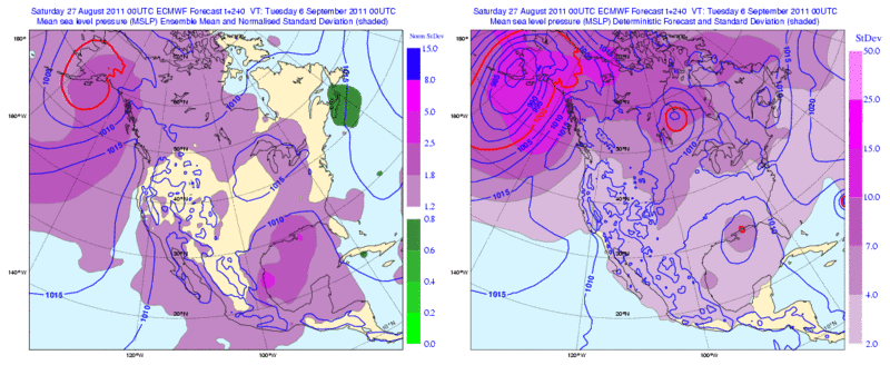
Rgv20 wrote:Looks like the GOM is going to get interesting as we head until Labor Day. 0zECMWF operational has a TC in ten day moving until Mobile and the 0zECMWF Ensembles show a lot of possibilities with regards to track of this potential TC.

This is the 0zECMWF Ensemble Forecast Map for 10 days. The dark shading shows that some of the ensembles favor a Western Gulf Threat.
Image


We certainly can use some rainfall and something to cool those outrageous temperatures.
0 likes   

User avatar
BigA
Professional-Met
Professional-Met
Posts: 1317
Joined: Sun Jul 24, 2005 10:56 pm

Re: Global Model Runs Discussion

#2635 Postby BigA » Sat Aug 27, 2011 6:22 pm

One thing I noticed from the most recent GFS run is that it has a hurricane that originated in the western Caribbean striking the northern Gulf Coast at the end of the run. While this means little about any storm, it does mean that this particular model forecasts that the death ridge will have moved or weakened enough to allow storm tracks northward toward the northern gulf coast. Other models seem to also indicate the end of the death ridge's regime.
0 likes   

User avatar
gatorcane
S2K Supporter
S2K Supporter
Posts: 23691
Age: 47
Joined: Sun Mar 13, 2005 3:54 pm
Location: Boca Raton, FL

#2636 Postby gatorcane » Sat Aug 27, 2011 6:33 pm

Interesting feature behind the big fish storm the models are latching onto...look as it stay relatively weak moving west north of the Leewards

18Z GFS long-range, 372 hours:

Image
0 likes   

HurricaneFan
Tropical Storm
Tropical Storm
Posts: 192
Age: 41
Joined: Tue Jan 18, 2011 6:16 pm
Location: Anguilla,Leeward Islands 18.3N 63.0W

Re: Global Model Runs Discussion

#2637 Postby HurricaneFan » Mon Aug 29, 2011 10:38 am

So what are the models saying about the Tropical Wave still in West Africa in terms of track and intensity?
Will it follow TD10 expected track out to sea(for now) or will move more west toward the Caribbean?
0 likes   

Patrick99
Category 5
Category 5
Posts: 1770
Joined: Mon May 24, 2004 3:43 pm
Location: SW Broward, FL

Re: Global Model Runs Discussion

#2638 Postby Patrick99 » Mon Aug 29, 2011 9:15 pm

HurricaneFan wrote:So what are the models saying about the Tropical Wave still in West Africa in terms of track and intensity?
Will it follow TD10 expected track out to sea(for now) or will move more west toward the Caribbean?


That's a big wave pounding in after TD12. Any models showing anything doing with it?
0 likes   

User avatar
cycloneye
Admin
Admin
Posts: 145275
Age: 68
Joined: Thu Oct 10, 2002 10:54 am
Location: San Juan, Puerto Rico

Re: Global Model Runs Discussion

#2639 Postby cycloneye » Tue Aug 30, 2011 6:16 am

Long range GFS has this.

Image

Saved image.
0 likes   
Visit the Caribbean-Central America Weather Thread where you can find at first post web cams,radars
and observations from Caribbean basin members Click Here

HurricaneWarning92
Category 2
Category 2
Posts: 520
Joined: Sat Jul 23, 2011 4:33 pm
Location: Pembroke Pines, S. Florida (Lat: 26.00N, Lon: 80.22W)

Re: Global Model Runs Discussion

#2640 Postby HurricaneWarning92 » Tue Aug 30, 2011 10:42 am

[quote="cycloneye"]Long range GFS has this.

http://img856.imageshack.us/img856/5386 ... wndpre.gif[/img]

Saved image.

i think thats the one that is coming offshore right behind Katia.
0 likes   
The posts in this forum are NOT official forecast and should not be used as such. They are just the opinion of the poster and may or may not be backed by sound meteorological data. They are NOT endorsed by any professional institution or storm2k.org. For official information, please refer to the NHC and NWS products.


Return to “2015”

Who is online

Users browsing this forum: No registered users and 1 guest