
This map is fallible at times, but it shows the highest 850 mb vorticity as a good bit south of 10 North.
http://tropic.ssec.wisc.edu/real-time/w ... oom=&time=
ATL: KATIA - Post Tropical - Discussion
Moderator: S2k Moderators
Re: ATL: INVEST 92L - Discussion
0 likes
Re:
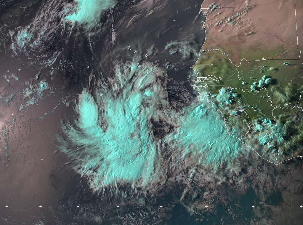
gatorcane wrote:The GOES floater on NHC site "East Atlantic" is flashing it looks like, making it difficult to find the center.
Anybody have any good visible loop links for this system?
The ramsdis imagery doesn't have a good closeup anymore, but the overall system is visible on the Africa and east Atlantic loop
http://rammb.cira.colostate.edu/ramsdis ... opical.asp
0 likes
-
wxman57

- Moderator-Pro Met

- Posts: 23173
- Age: 68
- Joined: Sat Jun 21, 2003 8:06 pm
- Location: Houston, TX (southwest)
Re: Re:
BigA wrote:The ramsdis imagery doesn't have a good closeup anymore, but the overall system is visible on the Africa and east Atlantic loop
http://rammb.cira.colostate.edu/ramsdis ... opical.asp
I can't find it on any image on that rammb website. The floater image is of the convection east of 92L. Here's a shot from my workstation. It does look like the ridge to its north may be weak enough to allow for it to track north of the Caribbean. Won't guarantee it 100% yet though. I'd put the center near 10.8N/23.7W.

0 likes
-
Extratropical94

- Professional-Met

- Posts: 3545
- Age: 31
- Joined: Wed Oct 20, 2010 6:36 am
- Location: Hamburg, Germany
- Contact:
Code Red - 70%
SHOWERS AND THUNDERSTORMS CONTINUE TO BECOME BETTER ORGANIZED IN
ASSOCIATION WITH A LOW PRESSURE AREA LOCATED ABOUT 400 MILES SOUTH
OF THE SOUTHERN CAPE VERDE ISLANDS. ENVIRONMENTAL CONDITIONS APPEAR
CONDUCIVE FOR FURTHER DEVELOPMENT OF THIS LOW...AND A TROPICAL
DEPRESSION COULD FORM DURING THE NEXT DAY OR TWO AS IT MOVES
WESTWARD AT 10 T0 15 MPH. THIS SYSTEM HAS A HIGH CHANCE...70
PERCENT...OF BECOMING A TROPICAL CYCLONE DURING THE NEXT 48 HOURS.
0 likes
54° 11' 59'' N, 9° 9' 20'' E
Boomer Sooner!
Go Broncos! Go Cards!
Clinching counties, one at a time: https://mob-rule.com/user-gifs/USA/xtrp94.gif
- Daniel
Boomer Sooner!
Go Broncos! Go Cards!
Clinching counties, one at a time: https://mob-rule.com/user-gifs/USA/xtrp94.gif
- Daniel

-
HurricaneMaster_PR

- Category 2

- Posts: 795
- Joined: Tue Jul 22, 2003 6:23 pm
- Location: San Juan, Puerto Rico
Re: ATL: INVEST 92L - Discussion
Latest TAFB forecast continues to move the system at a low latitude toward the west
http://www.nhc.noaa.gov/tafb_latest/atl ... BW_sm3.gif
http://www.nhc.noaa.gov/tafb_latest/atl ... BW_sm3.gif
0 likes
-
HurricaneWarning92
- Category 2
- Posts: 520
- Joined: Sat Jul 23, 2011 4:33 pm
- Location: Pembroke Pines, S. Florida (Lat: 26.00N, Lon: 80.22W)
Re:
wow it shifted noticeably westwards...
0 likes
The posts in this forum are NOT official forecast and should not be used as such. They are just the opinion of the poster and may or may not be backed by sound meteorological data. They are NOT endorsed by any professional institution or storm2k.org. For official information, please refer to the NHC and NWS products.
-
painkillerr
- S2K Supporter

- Posts: 129
- Age: 70
- Joined: Wed Aug 25, 2010 5:17 pm
- Location: San Juan, PR
-
wxman57
- Moderator-Pro Met
- Posts: 23173
- Age: 68
- Joined: Sat Jun 21, 2003 8:06 pm
- Location: Houston, TX (southwest)
Re: ATL: INVEST 92L - Discussion
A good argument for this disturbance gaining latitude more quickly than the pre-Irene disturbance would be the general low pressure to its north. For Irene, the SAL was VERY strong due to a massive high to its north. Not so with this disturbance:

Here's a shot I saved from August 17th. That's Irene-to-be around 31W near 11N-12N:

Here's a shot I saved from August 17th. That's Irene-to-be around 31W near 11N-12N:
0 likes
-
Scorpion


-
tolakram
- Admin

- Posts: 20185
- Age: 62
- Joined: Sun Aug 27, 2006 8:23 pm
- Location: Florence, KY (name is Mark)
Re: ATL: INVEST 92L - Discussion
EUMETSAT full disc, low res
http://oiswww.eumetsat.org/IPPS/html/MS ... /index.htm
Zoom in a bit (shift+click) then scroll to center 92L and select 12 images for loop.
Latest

http://oiswww.eumetsat.org/IPPS/html/MS ... /index.htm
Zoom in a bit (shift+click) then scroll to center 92L and select 12 images for loop.
Latest
0 likes
M a r k
- - - - -
Join us in chat: Storm2K Chatroom Invite. Android and IOS apps also available.
The posts in this forum are NOT official forecasts and should not be used as such. Posts are NOT endorsed by any professional institution or STORM2K.org. For official information and forecasts, please refer to NHC and NWS products.
-
painkillerr
- S2K Supporter
- Posts: 129
- Age: 70
- Joined: Wed Aug 25, 2010 5:17 pm
- Location: San Juan, PR
Re: ATL: INVEST 92L - Discussion
[quote="wxman57"]A good argument for this disturbance gaining latitude more quickly than the pre-Irene disturbance would be the general low pressure to its north. For Irene, the SAL was VERY strong due to a massive high to its north. Not so with this disturbance:
Wxman57, If I read you correctly, the strong SAL over Irene impeded her development until she approached 50w + or -. This is not so with 92L so development is likely to happen sooner (as it is already happenning). My question is, couldn't the high to the north impede the gain in latitude even if the SAL is not so strong?
Wxman57, If I read you correctly, the strong SAL over Irene impeded her development until she approached 50w + or -. This is not so with 92L so development is likely to happen sooner (as it is already happenning). My question is, couldn't the high to the north impede the gain in latitude even if the SAL is not so strong?
0 likes
-
HurricaneMaster_PR
- Category 2
- Posts: 795
- Joined: Tue Jul 22, 2003 6:23 pm
- Location: San Juan, Puerto Rico
Re: ATL: INVEST 92L - Discussion
DATE/TIME LAT LON CLASSIFICATION STORM
28/1745 UTC 9.9N 22.6W T1.0/1.0 92L
28/1745 UTC 9.9N 22.6W T1.0/1.0 92L
0 likes
-
wxman57
- Moderator-Pro Met
- Posts: 23173
- Age: 68
- Joined: Sat Jun 21, 2003 8:06 pm
- Location: Houston, TX (southwest)
Re: ATL: INVEST 92L - Discussion
painkillerr wrote:wxman57 wrote:A good argument for this disturbance gaining latitude more quickly than the pre-Irene disturbance would be the general low pressure to its north. For Irene, the SAL was VERY strong due to a massive high to its north. Not so with this disturbance:
Wxman57, If I read you correctly, the strong SAL over Irene impeded her development until she approached 50w + or -. This is not so with 92L so development is likely to happen sooner (as it is already happenning). My question is, couldn't the high to the north impede the gain in latitude even if the SAL is not so strong?
There isn't much of a high to the north compared to when Irene was tracking west across the Atlantic. The earlier development will also significantly increase the chance of it passing north of the Caribbean and recurving out to sea well east of the U.S. The 12z Euro is in through 144 hours, indicating a path north of the eastern Caribbean with a deep trof in its path just west of Bermuda. That would give it a clear shot to recurve between 55-65W.
0 likes
-
tolakram
- Admin
- Posts: 20185
- Age: 62
- Joined: Sun Aug 27, 2006 8:23 pm
- Location: Florence, KY (name is Mark)
Re: ATL: INVEST 92L - Discussion
Better link:
http://oiswww.eumetsat.org/IPPS/html/MS ... /index.htm
This is high res and you can shift+click to zoom pretty close.
latest image
http://oiswww.eumetsat.org/IPPS/html/MS ... /index.htm
This is high res and you can shift+click to zoom pretty close.
latest image
0 likes
M a r k
- - - - -
Join us in chat: Storm2K Chatroom Invite. Android and IOS apps also available.
The posts in this forum are NOT official forecasts and should not be used as such. Posts are NOT endorsed by any professional institution or STORM2K.org. For official information and forecasts, please refer to NHC and NWS products.
- - - - -
Join us in chat: Storm2K Chatroom Invite. Android and IOS apps also available.
The posts in this forum are NOT official forecasts and should not be used as such. Posts are NOT endorsed by any professional institution or STORM2K.org. For official information and forecasts, please refer to NHC and NWS products.
-
southerngale

- Retired Staff

- Posts: 27418
- Joined: Thu Oct 10, 2002 1:27 am
- Location: Southeast Texas (Beaumont area)
Please upload images before posting them. See this thread.
0 likes
Please support Storm2k by making a donation today. It is greatly appreciated! Click here: 
 my Cowboys my Rockets my Astros
my Cowboys my Rockets my Astros-
SFLcane

- S2K Supporter
- Posts: 10281
- Age: 48
- Joined: Sat Jun 05, 2010 1:44 pm
- Location: Lake Worth Florida
Re: ATL: INVEST 92L - Models
Heading NW out to sea possibly poseing a threat to bermuda on the 12z ECM..
0 likes
Who is online
Users browsing this forum: No registered users and 44 guests