


ENSO Updates (2007 thru 2023)
Moderator: S2k Moderators
Forum rules

The posts in this forum are NOT official forecasts and should not be used as such. They are just the opinion of the poster and may or may not be backed by sound meteorological data. They are NOT endorsed by any professional institution or STORM2K. For official information, please refer to products from the National Hurricane Center and National Weather Service.
-
South Texas Storms

- Professional-Met

- Posts: 4257
- Joined: Thu Jun 24, 2010 12:28 am
- Location: Houston, TX
-
Hurricaneman

- Category 5

- Posts: 7404
- Age: 45
- Joined: Tue Aug 31, 2004 3:24 pm
- Location: central florida
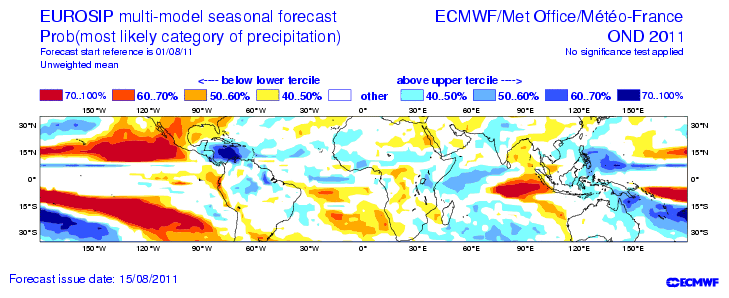
With latest EUROSIP forecast it is becoming more evident that a return to at least a weak La Nina is very much possible.
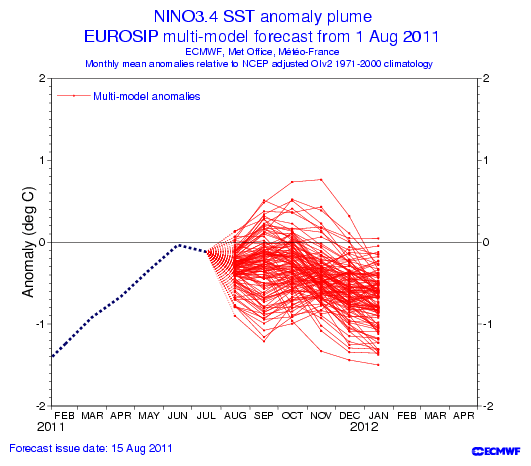
It also shows TX and parts of the south to have a warmer than average Fall.
FL, enjoy the current rains, the drier than average wx will take over by at least October into the winter.
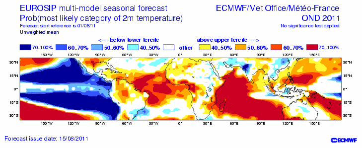
It also shows TX and parts of the south to have a warmer than average Fall.
FL, enjoy the current rains, the drier than average wx will take over by at least October into the winter.
0 likes
-
cycloneye

- Admin

- Posts: 149408
- Age: 69
- Joined: Thu Oct 10, 2002 10:54 am
- Location: San Juan, Puerto Rico
Re: ENSO=CPC 8/15/11 update=Nino 3.4 down to -0.5C
Climate Prediction Center 8/15/11 Update
Nino 3.4 is down from -0.4C of last week to -0.5C this week. Is now in the borderline between Neutral and La Nina.
Niño 4= -0.1ºC
Niño 3.4= -0.5ºC
Niño 3= -0.5ºC
Niño1+2= -0.1ºC

http://www.cpc.ncep.noaa.gov/products/a ... ts-web.pdf
Nino 3.4 is down from -0.4C of last week to -0.5C this week. Is now in the borderline between Neutral and La Nina.
Niño 4= -0.1ºC
Niño 3.4= -0.5ºC
Niño 3= -0.5ºC
Niño1+2= -0.1ºC
http://www.cpc.ncep.noaa.gov/products/a ... ts-web.pdf
0 likes
Visit the Caribbean-Central America Weather Thread where you can find at first post web cams,radars
and observations from Caribbean basin members Click Here
and observations from Caribbean basin members Click Here

Could see some big numbers this year, a weak La Nina strengthening into the Autumn with a neutral first half is nearly the ideal combo in theory...
0 likes
Personal Forecast Disclaimer:
The posts in this forum are NOT official forecast and should not be used as such. They are just the opinion of the poster and may or may not be backed by sound meteorological data. They are NOT endorsed by any professional institution or storm2k.org. For official information, please refer to the NHC and NWS products
The posts in this forum are NOT official forecast and should not be used as such. They are just the opinion of the poster and may or may not be backed by sound meteorological data. They are NOT endorsed by any professional institution or storm2k.org. For official information, please refer to the NHC and NWS products
-
cycloneye
- Admin
- Posts: 149408
- Age: 69
- Joined: Thu Oct 10, 2002 10:54 am
- Location: San Juan, Puerto Rico
Re: CPC 8/15/11 update=Borderline between Neutral/La Nina -0.5C
The forecasts by the models was for a La Nina to return by late fall and Winter.But it looks like is comming sooner.
0 likes
Visit the Caribbean-Central America Weather Thread where you can find at first post web cams,radars
and observations from Caribbean basin members Click Here
and observations from Caribbean basin members Click Here
-
cycloneye
- Admin
- Posts: 149408
- Age: 69
- Joined: Thu Oct 10, 2002 10:54 am
- Location: San Juan, Puerto Rico
Re: CPC 8/15/11 update=Borderline between Neutral/La Nina -0.5C
Here is the CFS model.The black line is above where it is now at -0.5C in mid August.

0 likes
Visit the Caribbean-Central America Weather Thread where you can find at first post web cams,radars
and observations from Caribbean basin members Click Here
and observations from Caribbean basin members Click Here
-
Hurricaneman
- Category 5
- Posts: 7404
- Age: 45
- Joined: Tue Aug 31, 2004 3:24 pm
- Location: central florida
Re: CPC 8/15/11 update=Borderline between Neutral/La Nina -0.5C
this could be another signal that hurricane season will go gangbusters within the next couple of weeks, la ninas tend to do that especially cape verde systems
0 likes
-
HurricaneWarning92
- Category 2

- Posts: 520
- Joined: Sat Jul 23, 2011 4:33 pm
- Location: Pembroke Pines, S. Florida (Lat: 26.00N, Lon: 80.22W)
Re: CPC 8/15/11 update=Borderline between Neutral/La Nina -0.5C
Hurricaneman wrote:this could be another signal that hurricane season will go gangbusters within the next couple of weeks, la ninas tend to do that especially cape verde systems
Yes, but most cape verde systems that form far in the eastern Atlantic end up going on vacation catching some fish...
0 likes
The posts in this forum are NOT official forecast and should not be used as such. They are just the opinion of the poster and may or may not be backed by sound meteorological data. They are NOT endorsed by any professional institution or storm2k.org. For official information, please refer to the NHC and NWS products.
-
Hurricaneman
- Category 5
- Posts: 7404
- Age: 45
- Joined: Tue Aug 31, 2004 3:24 pm
- Location: central florida
Re: CPC 8/15/11 update=Borderline between Neutral/La Nina -0.5C
HurricaneWarning92 wrote:Hurricaneman wrote:this could be another signal that hurricane season will go gangbusters within the next couple of weeks, la ninas tend to do that especially cape verde systems
Yes, but most cape verde systems that form far in the eastern Atlantic end up going on vacation catching some fish...
a majority of them do, but for many recurves, you can get 1 that pulls an isabel or 1938
0 likes
-
cycloneye
- Admin
- Posts: 149408
- Age: 69
- Joined: Thu Oct 10, 2002 10:54 am
- Location: San Juan, Puerto Rico
Re: CPC 8/15/11 update=Borderline between Neutral/La Nina -0.5C
ENSO models August update:

0 likes
Visit the Caribbean-Central America Weather Thread where you can find at first post web cams,radars
and observations from Caribbean basin members Click Here
and observations from Caribbean basin members Click Here
-
cycloneye
- Admin
- Posts: 149408
- Age: 69
- Joined: Thu Oct 10, 2002 10:54 am
- Location: San Juan, Puerto Rico
Re: CPC 8/22/11 update:Nino 3.4 below Neutral threshold at -0.7C
Climate Prediction Center 8/22/11 update
ENSO continues to drop towards cooler waters and in this update,it drops to -0.7C,below Neutral threshold.This means that La Nina is comming more rapidly than the forecasts said in past weeks.
Niño 4 -0.2ºC
Niño 3.4 -0.7ºC
Niño 3 -0.5ºC
Niño1+2 -0.3ºC

http://www.cpc.ncep.noaa.gov/products/a ... ts-web.pdf
ENSO continues to drop towards cooler waters and in this update,it drops to -0.7C,below Neutral threshold.This means that La Nina is comming more rapidly than the forecasts said in past weeks.
Niño 4 -0.2ºC
Niño 3.4 -0.7ºC
Niño 3 -0.5ºC
Niño1+2 -0.3ºC
http://www.cpc.ncep.noaa.gov/products/a ... ts-web.pdf
0 likes
Visit the Caribbean-Central America Weather Thread where you can find at first post web cams,radars
and observations from Caribbean basin members Click Here
and observations from Caribbean basin members Click Here
-
HurricaneFan
- Tropical Storm

- Posts: 192
- Age: 42
- Joined: Tue Jan 18, 2011 6:16 pm
- Location: Anguilla,Leeward Islands 18.3N 63.0W
Re: ENSO Updates
So any more updates on the developing La Nina?
I know it takes 3 months to officially declare it,but isn't it affecting the atmosphere already?
And if so,wouldn't that affect the remainder of the Cape Verde Season by making it more active and bringing more storms west because of a stronger ridge?
I know it takes 3 months to officially declare it,but isn't it affecting the atmosphere already?
And if so,wouldn't that affect the remainder of the Cape Verde Season by making it more active and bringing more storms west because of a stronger ridge?
0 likes

-
cycloneye
- Admin
- Posts: 149408
- Age: 69
- Joined: Thu Oct 10, 2002 10:54 am
- Location: San Juan, Puerto Rico
Re: ENSO=Breaking News=CPC Sept update=La Nina returns
Climate Prediction Center 9/8/11 Monthly update
Officially,La Nina is back!!
http://www.cpc.ncep.noaa.gov/products/a ... odisc.html
Synopsis: La Niña conditions have returned and are expected to gradually strengthen and continue into the Northern Hemisphere winter 2011-12.
La Niña conditions returned in August 2011 due to the strengthening of negative sea surface temperature (SST) anomalies across the eastern half of the equatorial Pacific Ocean (Fig. 1). With the exception of the far westernmost Niño-4 region, all of the latest weekly Niño index values were –0.5oC or less (Fig. 2). Also supporting the return of La Niña conditions was the strengthening of the below-average subsurface oceanic heat content anomaly (average temperature anomalies in the upper 300m of the ocean, Fig. 3), in response to increased upwelling and further shoaling of the thermocline across the eastern Pacific Ocean (Fig. 4). The atmospheric circulation over the tropical Pacific continued to exhibit La Niña characteristics, but remained weaker and less canonical than the wintertime atmospheric patterns. For example, convection continued to be suppressed near the Date Line, but remained south of the equator, while convection was only weakly enhanced near Papua New Guinea (Fig. 5). In addition, anomalous low-level easterly and upper-level westerly winds persisted over the central tropical Pacific. Collectively, these oceanic and atmospheric patterns reflect the return of La Niña conditions.
Over the last several months many models have predicted increasingly negative SST anomalies in the Nino-3.4 region during the upcoming Northern Hemisphere fall and winter. However, the majority of models continue to predict ENSO-neutral conditions for this period (Fig. 6). The NCEP Climate Forecast System (CFS) has performed quite well over the past several months (Fig. 7) capturing the recent decrease in SST anomalies. The better model performance, combined with the historical tendency for significant La Niña episodes (as in 2010-11) to be followed by relatively weaker La Niña episodes, leads to increased confidence that La Niña will persist into the winter. While it is not yet clear what the ultimate strength of this La Niña will be, La Niña conditions have returned and are expected to gradually strengthen and continue into the Northern Hemisphere winter 2011-12.
Across the contiguous United States, temperature and precipitation impacts associated with La Niña are expected to remain weak during the remainder of the Northern Hemisphere summer and early fall, and to generally strengthen during the late fall and winter. During September-November 2011, there is evidence that La Niña favors an increased chance of above-average temperatures across the mid-section of the country, and an increased chance of above-average precipitation across the Pacific Northwest (see 3-month seasonal outlook released on 18 August 2011).
0 likes
Visit the Caribbean-Central America Weather Thread where you can find at first post web cams,radars
and observations from Caribbean basin members Click Here
and observations from Caribbean basin members Click Here

-
cycloneye
- Admin
- Posts: 149408
- Age: 69
- Joined: Thu Oct 10, 2002 10:54 am
- Location: San Juan, Puerto Rico
Re:
gatorcane wrote:Should make for an interesting Late season, we may very well go into the Greek alphabet this year
It looks like an active late season with La Nina now entrenched in the Pacific There is a 50/50 chance that 2011 may reach greek.
0 likes
Visit the Caribbean-Central America Weather Thread where you can find at first post web cams,radars
and observations from Caribbean basin members Click Here
and observations from Caribbean basin members Click Here
-
cycloneye
- Admin
- Posts: 149408
- Age: 69
- Joined: Thu Oct 10, 2002 10:54 am
- Location: San Juan, Puerto Rico
Re: ENSO Updates=CPC Sept update=LA NINA IS BACK!
There is La Nina. Will it get stronger by the winter months?

0 likes
Visit the Caribbean-Central America Weather Thread where you can find at first post web cams,radars
and observations from Caribbean basin members Click Here
and observations from Caribbean basin members Click Here
Who is online
Users browsing this forum: No registered users and 272 guests