ATL: OPHELIA - Remnants - Discussion

Moderator: S2k Moderators

Message
Author
CrazyC83
Professional-Met
Professional-Met
Posts: 34002
Joined: Tue Mar 07, 2006 11:57 pm
Location: Deep South, for the first time!

Re: ATL: INVEST 98L - Discussion

#181 Postby CrazyC83 » Tue Sep 20, 2011 10:19 am

EDR1222 wrote:
wxman57 wrote:
P.S. Where is everyone? You'd think the hurricane season was over...


I think the continued recurving storms are not interesting to many people and that is the reason for the drop-off in interest. The fact is many of the ameteurs on here are weather enthusiasts and more specifically hurricane enthusiasts and get excited and exhilarated by an approaching storm. Unfortunatley, I have seen members get beat up on here pretty good by other members for so called "-removed-" or people asking them......"what, you want destruction?". I don't think anybody on here wants death and destruction, but if your seeing an image of a storm on satellite far out in the ocean and the models are showing it recurve well out at sea....the interest probably only goes so far for some. It's ok to like storms and to want to experience some wind and rain that comes with storms, but I think people have shyed away a bit because other members have told them it's not ok to feel that way. I am not speaking for everyone and this is just an observation that I have seen with some of the posts this year.


More people are interested when themselves or their friends are in the path, since they want to know more on what will happen to them. If storms go out to sea, they get much less interest.
0 likes   

User avatar
cycloneye
Admin
Admin
Posts: 145277
Age: 68
Joined: Thu Oct 10, 2002 10:54 am
Location: San Juan, Puerto Rico

Re: ATL: INVEST 98L - Discussion

#182 Postby cycloneye » Tue Sep 20, 2011 10:25 am

:uarrow: But,if anyone is a true enthusiastic tropical weather geek,you track everything from systems of landfall chances to in the middle of the ocean that are fish major canes.
0 likes   
Visit the Caribbean-Central America Weather Thread where you can find at first post web cams,radars
and observations from Caribbean basin members Click Here

dolebot_Broward_NW
Category 2
Category 2
Posts: 529
Joined: Fri Sep 10, 2004 6:38 am

Re: ATL: INVEST 98L - Discussion

#183 Postby dolebot_Broward_NW » Tue Sep 20, 2011 10:28 am

Quoting my wife: "Why are you looking at that, it's not coming here..."


CrazyC83 wrote:
EDR1222 wrote:
wxman57 wrote:
P.S. Where is everyone? You'd think the hurricane season was over...


I think the continued recurving storms are not interesting to many people and that is the reason for the drop-off in interest. The fact is many of the ameteurs on here are weather enthusiasts and more specifically hurricane enthusiasts and get excited and exhilarated by an approaching storm. Unfortunatley, I have seen members get beat up on here pretty good by other members for so called "-removed-" or people asking them......"what, you want destruction?". I don't think anybody on here wants death and destruction, but if your seeing an image of a storm on satellite far out in the ocean and the models are showing it recurve well out at sea....the interest probably only goes so far for some. It's ok to like storms and to want to experience some wind and rain that comes with storms, but I think people have shyed away a bit because other members have told them it's not ok to feel that way. I am not speaking for everyone and this is just an observation that I have seen with some of the posts this year.


More people are interested when themselves or their friends are in the path, since they want to know more on what will happen to them. If storms go out to sea, they get much less interest.
0 likes   

User avatar
cycloneye
Admin
Admin
Posts: 145277
Age: 68
Joined: Thu Oct 10, 2002 10:54 am
Location: San Juan, Puerto Rico

Re: ATL: INVEST 98L - Models

#184 Postby cycloneye » Tue Sep 20, 2011 10:30 am

The predict team analysis this morning of 98L.

http://www.met.nps.edu/~mtmontgo/P28L.html

P28L … 98L
11N, 38W
700 hPa


ECMWF: Tracks westward with a slight turn to the northwest on Day 5. Intensifies for a couple days, then gradually weakens a little over the next few days while remaining a pouch the entire five days.

GFS: Similar to ECMWF.

UKMET: Similar track to ECMWF & GFS. Intensifies immediately and stays strong.

NOGAPS: OUTLIER! (AND I WOULD GUESS WRONG) Depicts large 98L as small while it depicts nearby (to the northwest) tiny 99L as a large circulation. 98L dissipates (get sheared apart?) in about two days as it is merged into the "huge" 99L while over the Caribbean. NOTE: This determination is based upon the examination of 700 hPa. At lower levels, 99L is not so large and 98L is actually more intense. Down at 925 hPa, 98L tracks westward, just south of Hispaniola, which is similar to the 700-hPa pouches of the other models.

HWRF-GEN: Gradual intensification as it tracks just north of west.


ECMWF -7.0 v700 120h
GFS -7.6 v700 120h
UKMET -6.8 v700 120h
NOGAPS -5.1 v700 48h
0 likes   
Visit the Caribbean-Central America Weather Thread where you can find at first post web cams,radars
and observations from Caribbean basin members Click Here

HurricaneWarning92
Category 2
Category 2
Posts: 520
Joined: Sat Jul 23, 2011 4:33 pm
Location: Pembroke Pines, S. Florida (Lat: 26.00N, Lon: 80.22W)

Re: ATL: INVEST 98L - Discussion

#185 Postby HurricaneWarning92 » Tue Sep 20, 2011 10:31 am

EDR1222 wrote:I think the continued recurving storms are not interesting to many people and that is the reason for the drop-off in interest. The fact is many of the ameteurs on here are weather enthusiasts and more specifically hurricane enthusiasts and get excited and exhilarated by an approaching storm. Unfortunatley, I have seen members get beat up on here pretty good by other members for so called "-removed-" or people asking them......"what, you want destruction?". I don't think anybody on here wants death and destruction, but if your seeing an image of a storm on satellite far out in the ocean and the models are showing it recurve well out at sea....the interest probably only goes so far for some. It's ok to like storms and to want to experience some wind and rain that comes with storms, but I think people have shyed away a bit because other members have told them it's not ok to feel that way. I am not speaking for everyone and this is just an observation that I have seen with some of the posts this year.


Finally someone that understands us hurricane enthusiasts. 8-) We obviously dont want death (thatd be strange and crazy) or destruction. But im still here because i like weather not just hurricanes. I think its very interesting how a system forms. Whether it threatens land or goes out to see, is another matter. Thats why im watching 98L :D
0 likes   
The posts in this forum are NOT official forecast and should not be used as such. They are just the opinion of the poster and may or may not be backed by sound meteorological data. They are NOT endorsed by any professional institution or storm2k.org. For official information, please refer to the NHC and NWS products.

HurrMark
Category 2
Category 2
Posts: 769
Joined: Tue Aug 12, 2008 10:18 pm
Location: Somerville, MA

Re: ATL: INVEST 98L - Discussion

#186 Postby HurrMark » Tue Sep 20, 2011 10:42 am

cycloneye wrote::uarrow: But,if anyone is a true enthusiastic tropical weather geek,you track everything from systems of landfall chances to in the middle of the ocean that are fish major canes.


It's true...but even if you have a major hurricane out there that is of no threat to land (e. g. Katia), you really don't see much in the way of postings. That is why the E-Pac doesn't see much activity for the most part. People do not want to admit that they want a storm making landfall because it is not politically correct...however, it must be said that a weak tropical storm making landfall in Florida will garner much more interest than a cat-4 hurricane turning northward at 55W...the "hype" of today's media is likely a reason...and human nature (although I would think most people are more compassionate to the plight of others than even 40-50 years ago, there has always been an intrigue in calamities that keep us glued to the TV/computer).

Back on topic...98L looks pretty good. I am actually a bit surprised that it was not declared a TD at 11 AM. I would think that it will almost certainly be one at 5 PM. But as this season has shown (quantity rather than quality), it probably won't grow that strong. Perhaps it could do a Maria once it turns north and intensifies into a cat-1 Hurricane...assuming it stays an identifiable feature.
0 likes   

User avatar
ConvergenceZone
Category 5
Category 5
Posts: 5194
Joined: Fri Jul 29, 2005 1:40 am
Location: Northern California

#187 Postby ConvergenceZone » Tue Sep 20, 2011 10:48 am

This had to form since at the beginning of the month I predicted one more storm before September ends... :wink:
Probably one more in October and maybe one in November before the season comes to a close....

98L does look better this mornning...I think we should have a TS before too long.....
0 likes   

User avatar
tobol.7uno
Category 1
Category 1
Posts: 287
Age: 31
Joined: Sun Aug 28, 2011 11:01 pm
Location: DeBary, Fl
Contact:

Re: ATL: INVEST 98L - Models

#188 Postby tobol.7uno » Tue Sep 20, 2011 10:50 am

8 am models for 98L...
Image
0 likes   
My Tropical Weather Website: http://tropwx.com/
I do link exchange, so if you have a website we can share each others links.

User avatar
tobol.7uno
Category 1
Category 1
Posts: 287
Age: 31
Joined: Sun Aug 28, 2011 11:01 pm
Location: DeBary, Fl
Contact:

Re: ATL: INVEST 98L - Models

#189 Postby tobol.7uno » Tue Sep 20, 2011 10:51 am

Intensity forecasts are generally a little bit higher today...
Image
0 likes   
My Tropical Weather Website: http://tropwx.com/
I do link exchange, so if you have a website we can share each others links.

User avatar
tobol.7uno
Category 1
Category 1
Posts: 287
Age: 31
Joined: Sun Aug 28, 2011 11:01 pm
Location: DeBary, Fl
Contact:

Re: ATL: INVEST 98L - Discussion

#190 Postby tobol.7uno » Tue Sep 20, 2011 10:55 am

Starting to see some curvature in the clouds and a bit of rotation... May be a TD forming at any time.
Image
0 likes   
My Tropical Weather Website: http://tropwx.com/
I do link exchange, so if you have a website we can share each others links.

HurricaneWarning92
Category 2
Category 2
Posts: 520
Joined: Sat Jul 23, 2011 4:33 pm
Location: Pembroke Pines, S. Florida (Lat: 26.00N, Lon: 80.22W)

Re: ATL: INVEST 98L - Models

#191 Postby HurricaneWarning92 » Tue Sep 20, 2011 10:59 am

tobol.7uno wrote:8 am models for 98L...
http://img851.imageshack.us/img851/1446/al982011.png


There are bends back to the wnw, or in the case of the BAMD, wsw. The TVCN was showing a bend to the north, now it shows a bend back to the wnw...
0 likes   
The posts in this forum are NOT official forecast and should not be used as such. They are just the opinion of the poster and may or may not be backed by sound meteorological data. They are NOT endorsed by any professional institution or storm2k.org. For official information, please refer to the NHC and NWS products.

User avatar
tobol.7uno
Category 1
Category 1
Posts: 287
Age: 31
Joined: Sun Aug 28, 2011 11:01 pm
Location: DeBary, Fl
Contact:

Re: ATL: INVEST 98L - Models

#192 Postby tobol.7uno » Tue Sep 20, 2011 11:06 am

Well we all know BAM anything is all over the place all of the time, but the general shift I think was slightly to the west, with GFS ensemble still going due west.
0 likes   
My Tropical Weather Website: http://tropwx.com/
I do link exchange, so if you have a website we can share each others links.

clfenwi
Category 5
Category 5
Posts: 3331
Joined: Thu Jun 09, 2005 12:54 pm

Re: ATL: INVEST 98L - Models

#193 Postby clfenwi » Tue Sep 20, 2011 11:28 am

12Z GFS gives the system better definition than previous runs, though it starts to fade around 90h. Here's 120h, with the low just east of Puerto Rico:

Image
0 likes   

Caribwxgirl
S2K Supporter
S2K Supporter
Posts: 287
Joined: Mon Aug 15, 2011 7:25 pm
Location: Budapest, Hungary (from Kingston, Jamaica)

#194 Postby Caribwxgirl » Tue Sep 20, 2011 11:41 am

Well for me I am always on checking but not posting much...whether the storm is going to affect land or not I am here...but the truth is if I check 10 times a day when the system will not be affecting land, I check 30 times a day if there is a threat. Its just the way it is, we are more concerned and post more, look more at the systems if they may impact land.
0 likes   
Personal Forecast Disclaimer:
The posts in this forum are NOT official forecast. They are just the opinion of the poster and may or may not be backed by sound meteorological data. They are NOT endorsed by any professional institutions or storm2k.org. For official information refer to the NHC and NWS products.

User avatar
tobol.7uno
Category 1
Category 1
Posts: 287
Age: 31
Joined: Sun Aug 28, 2011 11:01 pm
Location: DeBary, Fl
Contact:

Re:

#195 Postby tobol.7uno » Tue Sep 20, 2011 11:52 am

Caribwxgirl wrote:Well for me I am always on checking but not posting much...whether the storm is going to affect land or not I am here...but the truth is if I check 10 times a day when the system will not be affecting land, I check 30 times a day if there is a threat. Its just the way it is, we are more concerned and post more, look more at the systems if they may impact land.

Makes sense... but enthusiasts always are tracking storms no matter what! Its like a hobby. I love doinfg it.
0 likes   
My Tropical Weather Website: http://tropwx.com/
I do link exchange, so if you have a website we can share each others links.

Caribwxgirl
S2K Supporter
S2K Supporter
Posts: 287
Joined: Mon Aug 15, 2011 7:25 pm
Location: Budapest, Hungary (from Kingston, Jamaica)

#196 Postby Caribwxgirl » Tue Sep 20, 2011 11:56 am

Anyone have the latest spaghetti models from the more reliable sources?
0 likes   
Personal Forecast Disclaimer:
The posts in this forum are NOT official forecast. They are just the opinion of the poster and may or may not be backed by sound meteorological data. They are NOT endorsed by any professional institutions or storm2k.org. For official information refer to the NHC and NWS products.

Adoquín
Tropical Storm
Tropical Storm
Posts: 140
Joined: Thu Jul 28, 2011 8:47 pm

#197 Postby Adoquín » Tue Sep 20, 2011 12:01 pm

dry air does not seem as bad as it was for earlier CVs. Not much african dust to speak about. Mr. Shear will determine the future on this one. Seems like it could miss it for at least a few days more if stays on the south of 14.
0 likes   

User avatar
Aja
Tropical Low
Tropical Low
Posts: 42
Age: 61
Joined: Wed Aug 24, 2011 1:21 pm
Location: Charleston, SC
Contact:

#198 Postby Aja » Tue Sep 20, 2011 12:11 pm

Some of us storm watchers just lurk without posting. Pretty educational and interesting reading everyone thoughts and predictions just the same...
0 likes   

User avatar
ouragans
Category 1
Category 1
Posts: 490
Age: 53
Joined: Sun Jun 12, 2011 12:09 pm
Location: Abymes, Guadeloupe F.W.I
Contact:

Re: ATL: INVEST 98L - Models

#199 Postby ouragans » Tue Sep 20, 2011 12:26 pm

I have this spaghetti from SFWMD
Image

Uploaded with ImageShack.us
0 likes   
Personal forecast disclaimer
This post is a personal point of view, not an information. Please refer to official statements for life-threatening decisions.

David '79, Frederic '79, Hugo '89, Iris, Luis & Marilyn '95, Georges '98, Lenny '99, Dean '07, Irma '17, Maria '17, Fiona '22, Philippe '23, Tammy '23
16°13'33.3,"6N -61°36'39.5"W

User avatar
HurricaneMaster_PR
Category 2
Category 2
Posts: 795
Joined: Tue Jul 22, 2003 6:23 pm
Location: San Juan, Puerto Rico

Re: ATL: INVEST 98L - Discussion

#200 Postby HurricaneMaster_PR » Tue Sep 20, 2011 12:43 pm

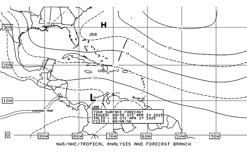
Latest TAFB Surface Forecast (72 hrs)
Image
0 likes   


Return to “2011”

Who is online

Users browsing this forum: No registered users and 2 guests