Global model runs discussion

Moderator: S2k Moderators

Message
Author
User avatar
cycloneye
Admin
Admin
Posts: 145303
Age: 68
Joined: Thu Oct 10, 2002 10:54 am
Location: San Juan, Puerto Rico

Re: Global Model Runs Discussion

#2981 Postby cycloneye » Sat Oct 01, 2011 3:32 pm

No consensus yet on Caribbean development between GFS and Euro.GFS continues to show Western Caribbean development that appears to start after the 10th.

10/1/11 - 12z GFS loop

This afternoon's Euro has a low developing NE of the Bahamas in 216 hours.And by the way,Euro has a couple of EPAC storms.

216 hours

Image

240 hours

Image
0 likes   
Visit the Caribbean-Central America Weather Thread where you can find at first post web cams,radars
and observations from Caribbean basin members Click Here

User avatar
Macrocane
Category 5
Category 5
Posts: 4218
Age: 36
Joined: Sun May 24, 2009 5:35 pm
Location: El Salvador

Re: Global Model Runs Discussion

#2982 Postby Macrocane » Sat Oct 01, 2011 4:53 pm

The models are in pretty good agreement about the EPAC developments, meanwhile in the Atlantic:
-CMC, UKMET and NOGAPS have a broad low in 6 days.
-GFS and FIM start to develop a tropical cyclone in 10 days or so, but the tracks are very different with the GFS showing a faster system.
-ECMWF lowers the pressures in the Caribbean in the last frames.
0 likes   

User avatar
cycloneye
Admin
Admin
Posts: 145303
Age: 68
Joined: Thu Oct 10, 2002 10:54 am
Location: San Juan, Puerto Rico

Re: Global Model Runs Discussion

#2983 Postby cycloneye » Sat Oct 01, 2011 6:04 pm

Macrocane wrote:The models are in pretty good agreement about the EPAC developments, meanwhile in the Atlantic:
-CMC, UKMET and NOGAPS have a broad low in 6 days.
-GFS and FIM start to develop a tropical cyclone in 10 days or so, but the tracks are very different with the GFS showing a faster system.
-ECMWF lowers the pressures in the Caribbean in the last frames.


GFS more slower at 18z.

http://mag.ncep.noaa.gov/NCOMAGWEB/appc ... mageSize=M
0 likes   
Visit the Caribbean-Central America Weather Thread where you can find at first post web cams,radars
and observations from Caribbean basin members Click Here

User avatar
blp
Category 5
Category 5
Posts: 2840
Age: 46
Joined: Thu Sep 09, 2004 7:51 pm
Location: Miami, FL
Contact:

Re: Global Model Runs Discussion

#2984 Postby blp » Sat Oct 01, 2011 10:40 pm

cycloneye wrote:
GFS more slower at 18z.


Yes it is. Seems a little more realistic. The MJO on the Euro is a little stronger and is now showing it up in our basin after the 11th. I still think by Monday or Tuesday we will start see something on the Euro. At that time the Euro will start picking up the range were the MJO will be most favorable. Let see what happens.

MJO Euro Saved 10/1
Image
0 likes   
The following post is NOT an official forecast and should not be used as such. It is just the opinion of the poster and may or may not be backed by sound meteorological data. It is NOT endorsed by any professional institution including storm2k.org For Official Information please refer to the NHC and NWS products.

LarryWx
S2K Supporter
S2K Supporter
Posts: 6305
Joined: Sun Sep 07, 2003 2:04 pm
Location: GA

#2985 Postby LarryWx » Sun Oct 02, 2011 2:04 am

Folks,
Fwiw, the 0Z Euro develops a homebrewish system in the Bahama's 10/10 and moves it very slowly NNW from there implying a threat to the corridor from N FL to the Carolina's around 10/12-13. Don't hug or shoot the messenger, especially because we're only talking about the very unreliable days 8-10 period of one model run.
0 likes   
Personal Forecast Disclaimer:
The posts in this forum are NOT official forecasts and should not be used as such. They are just the opinion of the poster and may or may not be backed by sound meteorological data. They are NOT endorsed by any professional institution or storm2k.org. For official information, please refer to the NHC and NWS products.

User avatar
cycloneye
Admin
Admin
Posts: 145303
Age: 68
Joined: Thu Oct 10, 2002 10:54 am
Location: San Juan, Puerto Rico

Re: Global Model Runs Discussion

#2986 Postby cycloneye » Sun Oct 02, 2011 5:37 am

GFS continues with the Caribbean development,but different to the past days of runs,it does not push back anymore in the timeframe as on the 00z run,it starts at 192 hours.

Image

Uploaded by imageshack.us
0 likes   
Visit the Caribbean-Central America Weather Thread where you can find at first post web cams,radars
and observations from Caribbean basin members Click Here

User avatar
ronjon
Category 5
Category 5
Posts: 4822
Joined: Fri Aug 19, 2005 5:17 pm
Location: Hernando Beach, FL

Possible Storm development off FL East Coast

#2987 Postby ronjon » Sun Oct 02, 2011 8:11 am

Global model support is picking up on a possible tropical or subtropical cyclone forming off the SE coast of FL in the 7-10 day outlook. 00z GFS, ECM, and CMC are all on board for some type of development either near east-central Cuba or SE FL coast. Discussion below captures the thinking.

From NWS Melbourne AFD:

SPEAKING OF NEXT WEEKEND...IT`S STARTING TO LOOK..."INTERESTING".
SINCE EARLY LAST WEEK...SPORADIC RUNS OF THE GLOBAL MODEL GUIDANCE
HAD BEEN SHOWING (OR AT LEAST HINTING AT) SOME SORT OF BAROCLINIC OR
SUBTROPICAL LOW FORMATION SOMEWHERE BETWEEN THE WEST-CTRL CARIBBEAN
SEA AND FL/BAHAMAS/GREATER ANTILLES. UNFORTUNATELY...IT LOOKS AS
THOUGH THE MORE RELIABLE GLOBAL GUIDANCE (GFS/ECM) IS STARTING TO
CONVERGE ON THIS SOLUTION COMING TO FRUITION TOWARD NEXT WEEKEND
(AND BEYOND). ADDITIONAL SHORT WAVE ENERGY SLIDING INTO THE SERN H50
TROUGH COUPLED WITH A BUILDING RIDGE OVER THE NERN CONUS PLACES ERN
NOAM INTO A REX BLOCK TYPE CONFIGURATION WITH A LOW LATITUDE H50
CUTOFF LOW INVOF 26-29N.

BAROCLINICALLY INDUCED SFC PRES FALLS LIKELY BENEATH AND ON THE EAST
(ASCENDING) SIDE OF THE LOW...SO LIKELY LOOKING AT SURFACE TROUGH
OR LOW FORMATION NEAR OR TO THE EAST OF FL STARTING NEXT WEEKEND.
TOO EARLY FOR SPECIFICS GIVEN HOW FAR OUT WE`RE TALKING (DAYS 7-10)
BUT THE TREND IS CERTAINLY THERE FOR AN INCREASINGLY WET/STORMY
PATTERN BY THE END OF NEXT WEEKEND...INTO EARLY THE FOLLOWING WEEK.
DEFINITELY SOMETHING TO KEEP AN EYE ON.

Moved to the global thread - no incipient disturbance is out there yet.
0 likes   

xironman
S2K Supporter
S2K Supporter
Posts: 2522
Joined: Sun Jun 10, 2007 4:53 pm
Location: NoVA

Re: Global Model Runs Discussion

#2988 Postby xironman » Sun Oct 02, 2011 1:56 pm

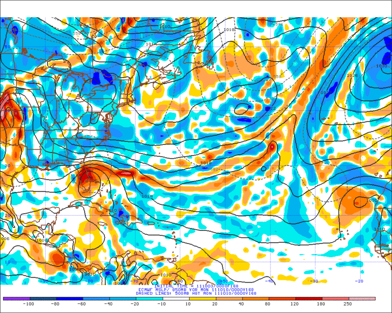
The Euro definitely has a subtropical look to it (note the 500 mb)

144
Image

168
Image[/URL]

192
Image

168
Image
0 likes   

User avatar
cycloneye
Admin
Admin
Posts: 145303
Age: 68
Joined: Thu Oct 10, 2002 10:54 am
Location: San Juan, Puerto Rico

Re: Global Model Runs Discussion

#2989 Postby cycloneye » Sun Oct 02, 2011 2:15 pm

:uarrow: Also the 12z Euro has a broad low pressure in the SW Caribbean. It wont be long until it joins GFS on development in that area.

The ensemble mean shows a pretty good pulse of favorable MJO comming very soon to octange 8.

Image
0 likes   
Visit the Caribbean-Central America Weather Thread where you can find at first post web cams,radars
and observations from Caribbean basin members Click Here

User avatar
blp
Category 5
Category 5
Posts: 2840
Age: 46
Joined: Thu Sep 09, 2004 7:51 pm
Location: Miami, FL
Contact:

Re: Global Model Runs Discussion

#2990 Postby blp » Sun Oct 02, 2011 4:00 pm

The latest GFS mjo is off the charts, literally. Wow never seen it that strong. I don't think it will verify that strong but interesting to look at.

Image

Image
0 likes   
The following post is NOT an official forecast and should not be used as such. It is just the opinion of the poster and may or may not be backed by sound meteorological data. It is NOT endorsed by any professional institution including storm2k.org For Official Information please refer to the NHC and NWS products.

User avatar
AJC3
Admin
Admin
Posts: 3999
Age: 61
Joined: Tue Aug 31, 2004 7:04 pm
Location: Ballston Spa, New York
Contact:

Re: Global Model Runs Discussion

#2991 Postby AJC3 » Mon Oct 03, 2011 4:45 am

Here's the preliminary HPC extended range discussion from this morning...

http://www.hpc.ncep.noaa.gov/preepd/preepd.html

PRELIMINARY EXTENDED FORECAST DISCUSSION...CORRECTION
NWS HYDROMETEOROLOGICAL PREDICTION CENTER CAMP SPRINGS MD
431 AM EDT MON OCT 03 2011

VALID 12Z FRI OCT 07 2011 - 12Z MON OCT 10 2011

...UNSETTLED WEATHER SLATED FOR THE WEST AND FLORIDA...

<snip>

FLORIDA HAS A PARTICULARLY INTERESTING PROBLEM THIS PERIOD.
ENERGY FROM THE WESTERLIES DROPS SOUTHWARD INTO THE STATE AND JUST
DRIFTS WESTWARD AS RIDGING OVER ITS TOP REMAINS PROGRESSIVE. THIS
SOLUTION WAS SUPPORTED BY THE GLOBAL ENSEMBLE MEMBERS /AS WELL AS
THE 00Z NAM AND 00Z CANADIAN/ AS EARLY AS THURSDAY AND CAUSES A
BROAD MONSOON-LIKE DEPRESSION IN THE WESTERN CARIBBEAN SEA. SEA
SURFACE TEMPERATURES REMAIN TEPID AND THE STRENGTHENING UPPER LOW
COULD LEAD TO A HYBRID/SUBTROPICAL CYCLONE FORMATION OVER THE
FLORIDA STRAITS /WHICH IS SUPPORTED BY A SIGNIFICANT NUMBER OF THE
12Z GLOBAL ENSEMBLE MEMBERS/ WITH POSSIBLE GALES AND HEAVY RAIN
NEAR NORTHEAST FLORIDA/GEORGIA FROM SATURDAY ONWARD. POSSIBLE
OCTOBER ANALOGS TO THIS FEATURE /WHICH SHOWED A SIMILAR PATTERN
ACROSS THE WEST AND HIGH PLAINS/ ARE THE OCTOBER 14 1956
QUASI-TROPICAL CYCLONE
AND THE OCTOBER 4 1976 CYCLONE /SUBTROPICAL
STORM FOUR/. THE TRACK OF THIS SYSTEM IS EXPECTED TO BE MORE
NORTHWESTERLY THAN NORTHERLY DUE TO THE BLOCKING RIDGE IN THE
EAST...MORE SIMILAR TO THE TRACK AND IMPACTS OF THE MAY 19-20 2009
GULF GALE WHICH CAUSED A LARGE AREA OF OVER SEVEN INCHES OF RAIN
ACROSS NORTHEAST FLORIDA. STAY TUNED.
------------------------------------------------------------------------------------

The October 1956 case is a particularly good analog...

Image
0 likes   

User avatar
AJC3
Admin
Admin
Posts: 3999
Age: 61
Joined: Tue Aug 31, 2004 7:04 pm
Location: Ballston Spa, New York
Contact:

Re: Global Model Runs Discussion

#2992 Postby AJC3 » Mon Oct 03, 2011 4:55 am

Accompanying HPC preliminary day 3-7 graphics...

(loop)
http://www.hpc.ncep.noaa.gov/basicwx/day0-7loop.html

(panel)
Image
0 likes   

KUEFC
Tropical Storm
Tropical Storm
Posts: 137
Joined: Thu Sep 11, 2008 6:19 am

Re: Global Model Runs Discussion

#2993 Postby KUEFC » Mon Oct 03, 2011 5:02 am

Quick question AJC3 and hope you have the patience to reply, as you know i am flying this coming saturday, can you see anything that would stop the flight? just wondering because as i am not all that clued up with these discussions etc, hope you can help because really starting to get a little paranoid about it now,
0 likes   

User avatar
AJC3
Admin
Admin
Posts: 3999
Age: 61
Joined: Tue Aug 31, 2004 7:04 pm
Location: Ballston Spa, New York
Contact:

Re: Global Model Runs Discussion

#2994 Postby AJC3 » Mon Oct 03, 2011 5:16 am

KUEFC wrote:Quick question AJC3 and hope you have the patience to reply, as you know i am flying this coming saturday, can you see anything that would stop the flight? just wondering because as i am not all that clued up with these discussions etc, hope you can help because really starting to get a little paranoid about it now,


Stop the flight? No. However, it's looking like cloudy/showery weather will be settling in this weekend, and is likely to remain here for several days...perhaps as long as 3 days or so. Will it spin up into something subtropical or (mostly) tropical? Too early to say. These things tend to be sloppy, more often than not. I'd keep tabs on this pretty closely. Feel free to PM me since this is my backyard, and I'll be keeping close tabs.
0 likes   

User avatar
NDG
S2K Supporter
S2K Supporter
Posts: 15446
Joined: Sun Jul 09, 2006 10:14 pm
Location: Orlando, FL

#2995 Postby NDG » Mon Oct 03, 2011 6:29 am

Looks like a wet weekend for at least eastern coastal FL by looking at the models with a strong easterly converging onshore winds setting in whether we see cyclonic develpment or not.
This past weekend was really nice across most of FL but we all know is too early in the fall to stay like that.

Image
0 likes   

User avatar
cycloneye
Admin
Admin
Posts: 145303
Age: 68
Joined: Thu Oct 10, 2002 10:54 am
Location: San Juan, Puerto Rico

Re: Global Model Runs Discussion

#2996 Postby cycloneye » Mon Oct 03, 2011 7:12 am

This morning's discussion of this potential development by Rob of Crown Weather.

The following post is NOT an official forecast and should not be used as such. It is just the opinion of the poster and may or may not be backed by sound meteorological data. It is NOT endorsed by any professional institution including storm2k.org. For Official Information please refer to the NHC and NWS products.

Rob Lightbown on October 3, 2011, 5:49 am

It appears that the weather will become quite “interesting” along the east coast of Florida from late this week through this upcoming Columbus Day weekend. An area of strong high pressure will anchor itself over the Mid-Atlantic and northeastern United States late this week and continuing into this upcoming weekend. This will lead to a lowering of barometric pressures from the western Caribbean northeastward into the central and northwestern Bahamas. The latest ensemble guidance of the GFS and European models, as well as the Canadian model is showing the potential of a broad area of low pressure to develop in the southwestern Caribbean as early as Thursday or Friday. The European ensemble model seems to hint that this low pressure system may develop into a tropical or sub-tropical storm as it tracks north-northeastward to near the Cayman Islands by about Sunday or next Monday and then near western or central Cuba around next Wednesday. The operational counterpart of the European model forecasts that the development of a tropical or sub-tropical storm may occur further north near Andros and Grand Bahama Island in the northwestern Bahamas on Sunday and then forecasts this potential storm to meander around south Florida right through the middle part of next week.

The GFS operational model develops the potential tropical/sub-tropical storm further offshore around next Monday and forecasts it to strengthen just off of the eastern North Carolina coast towards the end of next week, which then leads to the development of a second tropical/sub-tropical storm around October 16 or 17 which tracks across the northwestern Bahamas and right up the US East Coast as we get into October 18 and 19.

The pressure difference between any low pressure systems developing over the Florida Straits or the western Caribbean and this strong high pressure system over the Mid-Atlantic and northeastern United States will lead to strong easterly winds of 25 to 45 mph and very rough seas and riptides to develop across much of the Florida Peninsula starting late Thursday and continuing through this entire weekend. The strongest winds, heaviest rains and the likelihood of coastal flooding may be centered over central and northern Florida, roughly north of a line from Tampa to Vero Beach on Saturday, Sunday and Monday. These strong winds and heavy rains may then push northward into areas from South and North Carolina northward through the Mid-Atlantic states once we get into next Tuesday and next Wednesday.

So, everyone across the Florida Peninsula should be aware of the potential for several days of heavy rainfall, strong winds and coastal flooding & rip tides starting late Thursday and continuing right through this upcoming Columbus Day weekend.

0 likes   
Visit the Caribbean-Central America Weather Thread where you can find at first post web cams,radars
and observations from Caribbean basin members Click Here

User avatar
SFLcane
S2K Supporter
S2K Supporter
Posts: 10163
Age: 47
Joined: Sat Jun 05, 2010 1:44 pm
Location: Lake Worth Florida

Re: Global Model Runs Discussion

#2997 Postby SFLcane » Mon Oct 03, 2011 8:34 am

Have doupts this will get to strong but rather a hybrid/sloppy system as AJC3 mentioned. One thing thats begining to look increasingly likely is the potential for heavy rainfall across florida later this week into the weekend.
0 likes   

KUEFC
Tropical Storm
Tropical Storm
Posts: 137
Joined: Thu Sep 11, 2008 6:19 am

Re: Global Model Runs Discussion

#2998 Postby KUEFC » Mon Oct 03, 2011 8:45 am

Miami NWS Discussion

EXTENDED FORECAST...
THE LATEST LONG RANGE MODELS HAVE BACK OFF ON DEVELOPMENT OF LOW
PRESSURE ALONG THE STATIONARY FRONT OVER THE LOWER FLORIDA KEYS THIS
WEEKEND...AND ARE SHOWING THAT THE HIGH WILL CONTINUE TO STRENGTHEN
OVER THE TENNESSEE VALLEY. THIS WILL CONTINUE TO STRENGTHEN THE
PRESSURE GRADIENT OVER SOUTH FLORIDA LATE THIS WEEK INTO THIS
WEEKEND. SO THE NORTHEAST WINDS WILL CONTINUE TO INCREASE FROM
BREEZY TO WINDY CONDITIONS OVER THE METRO AREAS LATE THIS WEEK
INTO THIS WEEKEND. HOWEVER...THE ATMOSPHERE WILL STILL REMAIN DRY
FROM ABOUT 850 MBS ON UP. THEREFORE...THE ONLY INCREASE WILL BE
IN THE LOW LEVELS OF THE ATMOSPHERE FOR LATE THIS WEEK INTO THIS
WEEKEND. SO WILL CONTINUE THE SLIGHT CHANCE OF SHOWERS LATE THIS
WEEK INTO THIS WEEKEND FOR MOST OF SOUTH FLORIDA EXCEPT FOR THE
EAST COAST METRO AREAS WHERE A LOW END CHANCE OF SHOWERS WILL BE
IN PLACE.
0 likes   

User avatar
AJC3
Admin
Admin
Posts: 3999
Age: 61
Joined: Tue Aug 31, 2004 7:04 pm
Location: Ballston Spa, New York
Contact:

Re: Global Model Runs Discussion

#2999 Postby AJC3 » Mon Oct 03, 2011 9:03 am

KUEFC wrote:Miami NWS Discussion

EXTENDED FORECAST...
THE LATEST LONG RANGE MODELS HAVE BACK OFF ON DEVELOPMENT OF LOW
PRESSURE ALONG THE STATIONARY FRONT OVER THE LOWER FLORIDA KEYS THIS
WEEKEND...AND ARE SHOWING THAT THE HIGH WILL CONTINUE TO STRENGTHEN
OVER THE TENNESSEE VALLEY. THIS WILL CONTINUE TO STRENGTHEN THE
PRESSURE GRADIENT OVER SOUTH FLORIDA LATE THIS WEEK INTO THIS
WEEKEND. SO THE NORTHEAST WINDS WILL CONTINUE TO INCREASE FROM
BREEZY TO WINDY CONDITIONS OVER THE METRO AREAS LATE THIS WEEK
INTO THIS WEEKEND. HOWEVER...THE ATMOSPHERE WILL STILL REMAIN DRY
FROM ABOUT 850 MBS ON UP. THEREFORE...THE ONLY INCREASE WILL BE
IN THE LOW LEVELS OF THE ATMOSPHERE FOR LATE THIS WEEK INTO THIS
WEEKEND. SO WILL CONTINUE THE SLIGHT CHANCE OF SHOWERS LATE THIS
WEEK INTO THIS WEEKEND FOR MOST OF SOUTH FLORIDA EXCEPT FOR THE
EAST COAST METRO AREAS WHERE A LOW END CHANCE OF SHOWERS WILL BE
IN PLACE.


I disagree with that assessment on a couple of levels. 1) While the operational 03/00Z ECM is weaker with the surface low than the 02/00Z run, the globals in general have not backed off at all. There is a very strong signal for a cutoff 500 MB low from virtually EVERY SINGLE global and mesoscale model, as well as the ensembles. It's almost impossible not to get some kind of surface response as a result (see the PREEPD for analogs). 2) If and when a surface trough does form, the winds will be problematic. A broad/diffuse trough will put a dent in the pressure gradient, depending on where it forms. Breezy to windy conditions are by no means certain, particularly for south Florida, as the globals are tending to show more bagginess down in that area, with a tighter gradient and stronger onshore winds farther north. We'll see how this plays out.
0 likes   

User avatar
SFLcane
S2K Supporter
S2K Supporter
Posts: 10163
Age: 47
Joined: Sat Jun 05, 2010 1:44 pm
Location: Lake Worth Florida

Re: Global Model Runs Discussion

#3000 Postby SFLcane » Mon Oct 03, 2011 9:33 am

PRELIMINARY EXTENDED FORECAST DISCUSSION
NWS HYDROMETEOROLOGICAL PREDICTION CENTER CAMP SPRINGS MD
945 AM EDT MON OCT 03 2011

VALID 12Z FRI OCT 07 2011 - 12Z MON OCT 10 2011

A SMALL BUT POTENTIALLY SIGNIFICANT CYCLONE IS SHOWN BY THE ECMWF TO DEVELOP ALONG A RESIDUAL FRONTAL BOUNDARY DRAPED ACROSS THE BAHAMAS AROUND DAYS 5/6 BEFORE DRIFTING OVER FLORIDA. THE OTHER DETERMINISTIC MODELS ARE MUCH WEAKER WITH THIS SYSTEM. HOWEVER...THE ECMWF IS SUPPORTED BY ABOUT 10 TO 15 OF ITS OWN ENSEMBLE MEMBERS WHICH IS A SIGNIFICANT NUMBER. THUS...THE EVENT IS WORTH MONITORING AND IF IT COMES TO FRUITION COULD PRODUCE LOCALLY HEAVY RAIN/WIND FOR EASTERN FLORIDA...PERHAPS AS A HYBRID BAROCLINIC/BAROTROPIC LOW.

JAMES
0 likes   


Return to “2015”

Who is online

Users browsing this forum: No registered users and 11 guests