BTW, two big weather headlines in Texas right now:
* Tornado reported to have struck Mall of the Mainland in Texas City. Building evacuated as per concerns of structural integrity after a partial roof collapse (as per Chron.com).
* And Midland has received 4-6 inches of snow from this storm thus far. Their official NWS total for the season is up to 14.4 inches...and counting. That's the new seasonal record...on Jan. 9th no less.
Texas Winter 2011-2012...
Moderator: S2k Moderators
Forum rules
 The posts in this forum are NOT official forecast and should not be used as such. They are just the opinion of the poster and may or may not be backed by sound meteorological data. They are NOT endorsed by any professional institution or STORM2K.

The posts in this forum are NOT official forecast and should not be used as such. They are just the opinion of the poster and may or may not be backed by sound meteorological data. They are NOT endorsed by any professional institution or STORM2K.
-
Texas Snowman

- Storm2k Moderator

- Posts: 6197
- Joined: Fri Jan 25, 2008 11:29 am
- Location: Denison, Texas
0 likes
The above post and any post by Texas Snowman is NOT an official forecast and should not be used as such. It is just the opinion of the poster and may or may not be backed by sound meteorological data. It is NOT endorsed by any professional institution including storm2k.org. For official information, please refer to NWS products.
-
Portastorm

- Storm2k Moderator
- Posts: 9954
- Age: 63
- Joined: Fri Jul 11, 2003 9:16 am
- Location: Round Rock, TX
- Contact:
Re: Texas Winter 2011-2012...
Big O wrote:Some mets and well thought of amateurs on another message board are suggesting that the only winner (at least for the foreseeable future) of the -WPO, -AO will be Canada. While there is cross-polar flow, they argue that there is no mechanism to dislodge that air into the southern Plains, or much of the US for that matter. In fact, they point to the 240h European, which they claim depicts a Pacific firehouse jet (i.e., zonal flow) across the US.
I was informed that we need both west and east blocking to force the arctic air southward. However, another well-respected met told me you can't have both east and west blocking. I'm at a loss and am really frustrated with the lack of wintry weather. Someone talk me off the ledge.
The scenario you reference in your first paragraph is certainly plausible and could very well happen. I don't know if I'm the one to talk you off the ledge since I'm up there part of the time myself!
But that being said, I will just reiterate what I wrote over the weekend and that is that I am not trusting any computer models beyond 3-4 days. Any careful evaluation of the main cycle runs of the GFS/Euro/CMC for the last few days show widespread variability. And at this point, I'm highly skeptical of anyone or any scenario coming out and saying "oh, this is how it's going to shake out the next 2-3 weeks." My two pesos.
0 likes
Any forecasts under my name are to be taken with a grain of salt. Get your best forecasts from the National Weather Service and National Hurricane Center.
-
BrokenGlassRepublicn
- Category 1

- Posts: 483
- Joined: Sun Nov 20, 2011 8:07 pm
- Location: Richardson, Texas
So what do the next 24 hours look like for North Texas? In Richardson, the last shower just passed, and the sun is actually peaking through the clouds as we speak. Looks like we are in the dry slot of the ULL. Will there be any backside precip or are we done?
Last edited by BrokenGlassRepublicn on Mon Jan 09, 2012 4:34 pm, edited 1 time in total.
0 likes

Re:
BrokenGlassRepublicn wrote:So what do the next 24 hours look like for North Texas? In Richardson, the last shower just passed, and the sun is actually peaking through the clouds as we speack. Looks like we are in the dry slot of the ULL. Will there be any backside precip or are we done?
Dry slot right now for DFW. The ULL in west Texas will pivot through and more rain will develop, especially in the evening then continue until morning. Areas along and north of I-20 mostly.
FW
A REPRIEVE IN RAINFALL WILL OCCUR THROUGH THE EVENING HRS...AS
CURRENT DISTURBANCE MOVES NORTHEAST AWAY FROM NORTH TEXAS. SHOULD
SEE PREVAILING LOW MVFR/IFR CIGS THIS EVENING WITH VFR VSBYS AND
PATCHY -RA/-DZ.
UPPER LOW MOVES EAST AND THROUGH NORTH TEXAS ON TUESDAY. RA/ISOLATED
TS/CB CHANCES WILL INCREASE ONE LAST TIME BETWEEN MIDNIGHT AND MID
MORNING TUESDAY.
UPPER LOW MOVES AWAY FROM NORTH TEXAS LATE TUESDAY/TUESDAY EVENING
WITH RAIN CHANCES ENDING FROM SOUTH TO NORTH ACROSS THE AREA.
NORTH WINDS WILL AVERAGE 10-15 KTS ALL AIRPORTS...WITH A GRADUAL
SHIFT TO THE NORTHWEST ON TUESDAY IN RESPONSE TO THE UPPER LOW
MOVING ACROSS THE AREA.
0 likes
The above post and any post by Ntxw is NOT an official forecast and should not be used as such. It is just the opinion of the poster and may or may not be backed by sound meteorological data. It is NOT endorsed by any professional institution including Storm2k. For official information, please refer to NWS products.
Help support Storm2K!
-
orangeblood
- S2K Supporter

- Posts: 3895
- Joined: Tue Dec 15, 2009 6:14 pm
- Location: Fort Worth, TX
Re: Texas Winter 2011-2012...
Big O wrote:Some mets and well thought of amateurs on another message board are suggesting that the only winner (at least for the foreseeable future) of the -WPO, -AO will be Canada. While there is cross-polar flow, they argue that there is no mechanism to dislodge that air into the southern Plains, or much of the US for that matter. In fact, they point to the 240h European, which they claim depicts a Pacific firehouse jet (i.e., zonal flow) across the US.
I was informed that we need both west and east blocking to force the arctic air southward. However, another well-respected met told me you can't have both east and west blocking. I'm at a loss and am really frustrated with the lack of wintry weather. Someone talk me off the ledge.
While it looks like there is a lot of zonal flow projected, there is some nasty cold air forecast across the northern Pacific into Western Canada. All it would take is a buckling of the jet with energy shooting across in the northern stream to pull some of that arctic air down.
Now, what we really need is blocking to crank up across Greenland dropping the strong Polar Vortex down into the Great Lakes and we're in business!!
0 likes
-
Rgv20

- S2K Supporter
- Posts: 2466
- Age: 39
- Joined: Wed Jan 05, 2011 5:42 pm
- Location: Edinburg/McAllen Tx
Re: Texas Winter 2011-2012...
Portastorm wrote:HPC chimes in this afternoon with some interesting comments about the model runs:
EXTENDED FORECAST DISCUSSION
NWS HYDROMETEOROLOGICAL PREDICTION CENTER CAMP SPRINGS MD
224 PM EST MON JAN 09 2012
12Z CYCLE UPDATE...SUBTLE DIFFERENCES ALOFT...PARTICULARLY OVER
THE SOUTHERN PLAINS AND THE DESERT SOUTHWEST...REMAIN UNRESOLVED
BEYOND DAY 5 GIVEN THE DIFFERENCES BETWEEN THE MUCH FASTER GFS AND
THE SLOWER...ECMWF. THE FORECAST PHILOSOPHY DOESNT CHANGE
MUCH...AND PROGS WERE NOT UPDATED FOR THE FINAL. THE THOUGHT IS TO
MAINTAIN THE BULK OF THE ENERGY INTO DAY 4-5 IN THE NRN GULF OF
CALIFORNIA WITH THE SOUTHERN STREAM EJECTING SHORTWAVES ENEWD
ACROSS TEXAS...THE SOUTHERN PLAINS AND THE SOUTHEAST. UNLIKE THE
PRESENT SYSTEM...MODELS NEVER DEVELOP MUCH IN THE WAY OF A
SOUTHERN STREAM SURFACE WAVE...GIVEN COLD HIGH PRESSURE WILL BE
LOCKED IN PLACE...QUITE STABLE AND AN OPEN GULF OF MEXICO AND ITS
LOW-LEVEL MOISTURE WILL BE CONFINED TO THE RIO GRANDE VALLEY FOR
MUCH OF THE MEDIUM RANGE/EXTENDED.
Can you guys in north Texas lend us some of that cold air for late week until the weekend??
0 likes
The following post is NOT an official forecast and should not be used as such. It is just the opinion of the poster and may or may not be backed by sound meteorological data. It is NOT endorsed by any professional institution including storm2k.org For Official Information please refer to the NHC and NWS products.
-
northtxboy

- Category 1
- Posts: 262
- Age: 44
- Joined: Mon Jan 03, 2011 1:50 pm
- Location: Windom Tx
- Contact:
Hello everyone!!! Been working in Bastrop but now I am home. Seems to be a slow start to winter. This time last year I thought I was going to freeze to death  I havnt been up on the models yet but from reading what some of you are posting it doesnt sound too exciting. But we are getting rain which is a good thing, I would rather have cold rain and no snow than nothing at all. It seems that wxman57 is the winter grinch this year. I hate when he post cause 99.9.999% of the time he is right.. WHY CANT THAT MAN BE WRONG JUST ONCE!!!!!!!!!!!!! Portastorm is still depressed cause he has not got snow and he has to watch everyone else have fun with snow. We may want to keep a eye on him this year he may hang himself. Well I will start doing research and watchin models and give my own opinon on what I think will happen. Happy new year everone!!!
I havnt been up on the models yet but from reading what some of you are posting it doesnt sound too exciting. But we are getting rain which is a good thing, I would rather have cold rain and no snow than nothing at all. It seems that wxman57 is the winter grinch this year. I hate when he post cause 99.9.999% of the time he is right.. WHY CANT THAT MAN BE WRONG JUST ONCE!!!!!!!!!!!!! Portastorm is still depressed cause he has not got snow and he has to watch everyone else have fun with snow. We may want to keep a eye on him this year he may hang himself. Well I will start doing research and watchin models and give my own opinon on what I think will happen. Happy new year everone!!!
0 likes
-
WeatherNewbie
- Tropical Storm

- Posts: 235
- Joined: Mon Mar 22, 2010 3:42 pm
- Location: Richardson, Texas
Re: Texas Winter 2011-2012...
northtxboy wrote:Hello everyone!!! Been working in Bastrop but now I am home. Seems to be a slow start to winter. This time last year I thought I was going to freeze to death
wxman57 has been wrong. 2 days after he made that post, dallas got 4 inches of snow. granted, i had to go back two years to find an instance of him being wrong.
0 likes
The above post is NOT an official forecast and should not be used as such. It is just the opinion of the poster and may or may not be backed by sound meteorological data. It is NOT endorsed by any professional institution including storm2k.org. For official information, please refer to NWS products.
-
mushi-tan
Re: Texas Winter 2011-2012...
Posted on another board is the following graphic, which shows the temperature anomalies for all days during the January 15-25 period for the last 61 years during La Niña events with ENSO R3.4 anomalies in the -1.5°C to -0.7°C range, AO in the -2.00 to 0.00 range, and PNA in the -1.00 to +0.25 range:
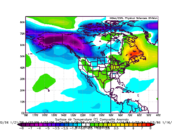
As you can see, it was cold in Alaska and the Yukon (connecting to cold anomalies in northeastern Siberia) but above normal in the south central USA. According to the expert who posted that graphic, the closest analog years are 1954 and 1984, when very warm Februarys happened. The CFSv2 ensembles are also hinting at a warm February.
As you can see, it was cold in Alaska and the Yukon (connecting to cold anomalies in northeastern Siberia) but above normal in the south central USA. According to the expert who posted that graphic, the closest analog years are 1954 and 1984, when very warm Februarys happened. The CFSv2 ensembles are also hinting at a warm February.
0 likes
-
Texas Snowman
- Storm2k Moderator
- Posts: 6197
- Joined: Fri Jan 25, 2008 11:29 am
- Location: Denison, Texas
Welcome aboard Mushi-Tan. Who knows, those analog years may be right. You know, that sounds about like something that austinrunner was saying a few days ago. We'll see...
0 likes
The above post and any post by Texas Snowman is NOT an official forecast and should not be used as such. It is just the opinion of the poster and may or may not be backed by sound meteorological data. It is NOT endorsed by any professional institution including storm2k.org. For official information, please refer to NWS products.
-
wxman57

- Moderator-Pro Met

- Posts: 23170
- Age: 68
- Joined: Sat Jun 21, 2003 8:06 pm
- Location: Houston, TX (southwest)
Re: Texas Winter 2011-2012...
WeatherNewbie wrote:northtxboy wrote:Hello everyone!!! Been working in Bastrop but now I am home. Seems to be a slow start to winter. This time last year I thought I was going to freeze to death
wxman57 has been wrong. 2 days after he made that post, dallas got 4 inches of snow. granted, i had to go back two years to find an instance of him being wrong.
Yep, must have missed that one.
I think I've had enough rain now. My gauge had 6.7" from 6am to 3pm today. Cars stalled out and abandoned on the various roads leading to my house. Quite a flood in the streets, at least.
0 likes
-
orangeblood
- S2K Supporter
- Posts: 3895
- Joined: Tue Dec 15, 2009 6:14 pm
- Location: Fort Worth, TX
Re: Texas Winter 2011-2012...
mushi-tan wrote:Posted on another board is the following graphic, which shows the temperature anomalies for all days during the January 15-25 period for the last 61 years during La Niña events with ENSO R3.4 anomalies in the -1.5°C to -0.7°C range, AO in the -2.00 to 0.00 range, and PNA in the -1.00 to +0.25 range:
As you can see, it was cold in Alaska and the Yukon (connecting to cold anomalies in northeastern Siberia) but above normal in the south central USA. According to the expert who posted that graphic, the closest analog years are 1954 and 1984, when very warm Februarys happened. The CFSv2 ensembles are also hinting at a warm February.
One thing I've learned so far, during this very unique winter, is it seems you can throw all of the analog years out the window....nothing seems to be going as most pro long range mets have forecast!!! The above forecast may or may not come to fruition but SO FAR this winter nothing seems to be adding up right
0 likes

-
Portastorm
- Storm2k Moderator
- Posts: 9954
- Age: 63
- Joined: Fri Jul 11, 2003 9:16 am
- Location: Round Rock, TX
- Contact:
@northtxboy -- good to see you back! Don't worry, I'm not so bummed yet that I'm ready to jump!
@mushi-tan -- that is a very interesting and compelling graphic. It would seem the odds don't favor the kind of winter most of us want.
@mushi-tan -- that is a very interesting and compelling graphic. It would seem the odds don't favor the kind of winter most of us want.
0 likes
Any forecasts under my name are to be taken with a grain of salt. Get your best forecasts from the National Weather Service and National Hurricane Center.
-
jasons2k

- Storm2k Executive

- Posts: 8290
- Age: 52
- Joined: Wed Jul 06, 2005 12:32 pm
- Location: The Woodlands, TX
Re: Texas Winter 2011-2012...
wxman57 wrote:I think I've had enough rain now. My gauge had 6.7" from 6am to 3pm today. Cars stalled out and abandoned on the various roads leading to my house. Quite a flood in the streets, at least.
And I'm happy with my measly .40" yesterday and 1.75" today for a total of 2.15"
0 likes
-
wall_cloud

- Professional-Met

- Posts: 401
- Age: 49
- Joined: Sun Dec 04, 2005 7:32 am
- Location: Bartlett, TN
- Contact:
Re:
wall_cloud wrote:Midland is up to 10.4" as of last check. Wow
That is phenomenal for a place that doesn't have that many big ticket snow totals. Looking at radar returns, I say they might push for a foot!
Edit: Where is natlib and those snow pictures from san angelo?!
0 likes
The above post and any post by Ntxw is NOT an official forecast and should not be used as such. It is just the opinion of the poster and may or may not be backed by sound meteorological data. It is NOT endorsed by any professional institution including Storm2k. For official information, please refer to NWS products.
Help support Storm2K!
Help support Storm2K!
-
southerngale

- Retired Staff

- Posts: 27418
- Joined: Thu Oct 10, 2002 1:27 am
- Location: Southeast Texas (Beaumont area)
About 4 inches here today... and a little last night. The ditches overflowed into the yards. My yard was a lake, with very little grass showing. I got picture happy, but not sure if I'll post pics of "flooded" yards.
It was really nice!
It was really nice!
0 likes
Please support Storm2k by making a donation today. It is greatly appreciated! Click here: 
 my Cowboys my Rockets my Astros
my Cowboys my Rockets my Astros-
wall_cloud
- Professional-Met
- Posts: 401
- Age: 49
- Joined: Sun Dec 04, 2005 7:32 am
- Location: Bartlett, TN
- Contact:
San Angelo is sitting between 1.0-1.3 right now at the airport. Still coming down quite good. Also notice the upper low is still tracking ESE along I-10 which could bring the deformation zone farther south.
0 likes
My comments are my own and do not reflect those of NOAA or the National Weather Service.
Who is online
Users browsing this forum: No registered users and 76 guests