ENSO Updates (2007 thru 2023)

This is the general tropical discussion area. Anyone can take their shot at predicting a storms path.

Moderator: S2k Moderators

Forum rules

The posts in this forum are NOT official forecasts and should not be used as such. They are just the opinion of the poster and may or may not be backed by sound meteorological data. They are NOT endorsed by any professional institution or STORM2K. For official information, please refer to products from the National Hurricane Center and National Weather Service.

Help Support Storm2K
Message
Author
User avatar
Cyclenall
Category 5
Category 5
Posts: 6666
Joined: Thu Jun 08, 2006 10:01 pm
Location: Ontario, Canada

La Nina

#1841 Postby Cyclenall » Sun Jan 29, 2012 5:45 pm

Haven't checked ENSO since early September. Our winter has been very warm so far and the amount of snow we have on the ground is so little compared to normal; I have never seen a winter this tame in my life. There is a melt of the snow every week, usually this only occurs once or twice a winter! If this pattern were to continue into February and March, that would be the first time our winter had no big events at all and no equalization balance for the duration. My prediction for February and maybe into March was either complete snowmageddon or the same tranquil pattern with very little snow and very warm temps. So far it's looking like more of the same here, with ridiculously low amounts of snow and some rain in the late January-February period.

This winter is turning out exactly the way I wanted it to, pretty rare. I actually want it to get as warm as possible and then quickly go straight into Spring by the start of March. With that in mind, I want this La Nina to become as strong as possible and last as long as possible as this is what brings me the best weather here for the most part. So far the La Nina is staying firm between weak and moderate so I'm curious to see if the predictions are wrong and it will actually intensify during the next few months into Spring which would really be a curve ball for most I would assume.

Ptarmigan wrote:Back to back El Nino winters are rare, but they do occur. Back to back La Nina winters have happened more often and even occurred in threes!

All data goes back to 1950.

*Cut*

Years that went from La Nina to El Nino
1952
1957
1972
1976
2006
2009


NOAA
http://www.cpc.ncep.noaa.gov/products/a ... ears.shtml

There are some patterns within that little data set that I found interesting. The first one is the separation between the paired years is 5 (1952-1957), 4 (1972-1976), 3 (2006-2009) (5,4,3); Second one is the pairs being compared to each other is 2 (Two decades between the 50s and 70s) and 3 (Three decades between the 70s and 00s) (2,3); Third is the paired years themselves being 2 events in the 50s, 70s, and 00s.

I was just wondering this today, what theoretically happens as the ENSO dips further and further (lets say below -3.5ºC Nino 3.4) and just continued like that. The Pacific would be getting extremely cold and most definitely record breaking but for maybe the Atlantic season and for New England/Ontario what would happen to our weather? Would our winter get warmer and warmer until it becomes insane or would there be little effect already? Remember I'm just talking in theory.
0 likes   

User avatar
gigabite
S2K Supporter
S2K Supporter
Posts: 916
Age: 72
Joined: Wed May 05, 2004 4:09 pm
Location: Naples, Florida

Re: ENSO Updates

#1842 Postby gigabite » Sun Jan 29, 2012 6:13 pm

I don't think that the warm winter has much to do with the Nina's. There is a large anomaly in the northwest Pacific that is as yet un-named.
0 likes   

User avatar
Ptarmigan
Category 5
Category 5
Posts: 5313
Joined: Wed Aug 16, 2006 9:06 pm

Re: ENSO Updates

#1843 Postby Ptarmigan » Mon Jan 30, 2012 12:26 pm

gigabite wrote:I don't think that the warm winter has much to do with the Nina's. There is a large anomaly in the northwest Pacific that is as yet un-named.


Interesting you mention that. There are so many atmospheric and ocean patterns we have discovered and new ones yet to be identified. I would guess it is probably related to Western Pacific Oscillation and Pacific North America Teleconnection.
0 likes   

User avatar
cycloneye
Admin
Admin
Posts: 145296
Age: 68
Joined: Thu Oct 10, 2002 10:54 am
Location: San Juan, Puerto Rico

Re: ENSO Updates

#1844 Postby cycloneye » Mon Jan 30, 2012 2:49 pm

Climate Prediction Center 1/30/12 update

Nino 3.4 remains at -1.1C,the same reading from last week's update.

http://www.cpc.ncep.noaa.gov/products/a ... ts-web.pdf
0 likes   
Visit the Caribbean-Central America Weather Thread where you can find at first post web cams,radars
and observations from Caribbean basin members Click Here

User avatar
cycloneye
Admin
Admin
Posts: 145296
Age: 68
Joined: Thu Oct 10, 2002 10:54 am
Location: San Juan, Puerto Rico

Re: ENSO=BoM 2/1/12 update=La Nina mantains steady

#1845 Postby cycloneye » Wed Feb 01, 2012 6:56 am

Australian 2/1/12 update

La Nina continues to mantain steady,but is forecast to weaken and then turn ENSO to Neutral by late Spring.

La Niña continues with little change

Issued on Wednesday 1 February | Product Code IDCKGEWWOO

La Niña conditions showed only small changes over the past fortnight and are expected to maintain an influence upon Australian climate over the coming months.

Over the past fortnight, sea surface temperatures in the central tropical Pacific cooled slightly, reversing the recent warming trend. However other indicators of La Niña, such as the Southern Oscillation Index (SOI), trade winds, and cloudiness over the equatorial Pacific Ocean have generally remained steady, below their December peak but clearly exceeding La Niña thresholds.

http://www.bom.gov.au/climate/enso/
0 likes   
Visit the Caribbean-Central America Weather Thread where you can find at first post web cams,radars
and observations from Caribbean basin members Click Here

User avatar
Hurricaneman
Category 5
Category 5
Posts: 7351
Age: 45
Joined: Tue Aug 31, 2004 3:24 pm
Location: central florida

Re: ENSO=BoM 2/1/12 update=La Nina mantains steady

#1846 Postby Hurricaneman » Wed Feb 01, 2012 3:14 pm

I think the ENSO this year will be similar to what happened in 2006 when it became an El Nino around late may early june except this one will change at a slower pace and become an el nino August into September which may not kill of the hurricane season durring peak time, but will kill off a late season
0 likes   

User avatar
Macrocane
Category 5
Category 5
Posts: 4218
Age: 36
Joined: Sun May 24, 2009 5:35 pm
Location: El Salvador

Re: ENSO=BoM 2/1/12 update=La Nina mantains steady

#1847 Postby Macrocane » Wed Feb 01, 2012 6:32 pm

Like I've said in previous posts I don't think we're going to see an El Niño, it would be rare to have an El Niño-La Niña-La Niña-El Niño. Neutral has the highest chance for 2012, just my personal opinion.
0 likes   

User avatar
gigabite
S2K Supporter
S2K Supporter
Posts: 916
Age: 72
Joined: Wed May 05, 2004 4:09 pm
Location: Naples, Florida

Re: ENSO Updates

#1848 Postby gigabite » Sun Feb 05, 2012 9:44 am

Image


It looks like that anomaly in the NW Pacific is diminishing, and moving SE.
0 likes   

User avatar
cycloneye
Admin
Admin
Posts: 145296
Age: 68
Joined: Thu Oct 10, 2002 10:54 am
Location: San Juan, Puerto Rico

Re: ENSO=CPC 2/6/12 update=Nino 3.4 down to -1.2C

#1849 Postby cycloneye » Mon Feb 06, 2012 1:17 pm

Climate Prediction Center 2/6/12 update

The moderate La Nina continues for another week as the data from this week's update shows Nino 3.4 down to -1.2C,more colder than last week's update of -1.1C.

http://www.cpc.ncep.noaa.gov/products/a ... ts-web.pdf

Image
0 likes   
Visit the Caribbean-Central America Weather Thread where you can find at first post web cams,radars
and observations from Caribbean basin members Click Here

User avatar
cycloneye
Admin
Admin
Posts: 145296
Age: 68
Joined: Thu Oct 10, 2002 10:54 am
Location: San Juan, Puerto Rico

Re: ENSO=CPC Febuary update=Neutral conditions by March-May

#1850 Postby cycloneye » Thu Feb 09, 2012 9:47 am

Climate Prediction Center Febuary update

La Nina will be gone by the Spring to then have Neutral conditions by the Summer. The big question is if is going to stay Neutral all the way during summer and fall,or El Nino starts to show it's head sooner.

Synopsis: La Niña is likely to transition to ENSO-neutral conditions during March-May 2012.

A mature La Niña continued during January 2012, as below-average sea surface temperatures (SST) persisted across the equatorial Pacific Ocean (Fig. 1). The weekly SST indices remained near -1.0oC in the Niño-3.4 and Niño-4 regions (Fig. 2). However, the negative SST anomalies weakened in the far eastern Pacific, indicated by warming in the Niño-1+2 and Niño-3 regions. The oceanic heat content (average temperature in the upper 300m of the ocean) anomalies also weakened slightly (Fig. 3), but continued to reflect an extensive area of below-average subsurface temperatures east of the Date Line (Fig. 4). Also, anomalous low-level easterly and upper-level westerly winds persisted over the central and west-central Pacific. Convection remained suppressed in the western and central Pacific, and enhanced over Indonesia (Fig. 5). Collectively, the oceanic and atmospheric patterns reflect a weak-to-moderate strength La Niña.

A majority of models predict La Niña to weaken through the rest of the Northern Hemisphere winter 2011-12, and then to dissipate during the spring 2012 (Fig. 6). Also, there is evidence of a downwelling phase of an eastward-propagating oceanic Kelvin wave (red shading, Fig. 4), which may increase temperatures across the Pacific in the next couple of months. The combination of a weakening subsurface temperature anomaly, the historical seasonal evolution, and forecaster preference for the average dynamical model prediction favors a return to ENSO-neutral conditions during the Northern Hemisphere spring, which are likely to continue into the summer. Therefore La Niña is likely to transition to ENSO-neutral conditions during March-May 2012 (see CPC/IRI consensus forecast).

Because the strength of impacts in the United States is not necessarily related to the exact strength of La Niña in the tropical Pacific, we expect La Niña impacts to continue even as the episode weakens. Over the U.S. during February - April 2012, there is an increased chance of above-average temperatures across the south-central and southeastern U.S., and below-average temperatures in the northwestern U.S. Also, above-average precipitation is favored across most of the northern tier of states (except the north-central U.S.) and in the Ohio and Tennessee Valleys, and drier-than-average conditions are more likely across the southern tier of the U.S. (see 3-month seasonal outlook released on 19 January 2012).

http://www.cpc.ncep.noaa.gov/products/a ... odisc.html
0 likes   
Visit the Caribbean-Central America Weather Thread where you can find at first post web cams,radars
and observations from Caribbean basin members Click Here

User avatar
cycloneye
Admin
Admin
Posts: 145296
Age: 68
Joined: Thu Oct 10, 2002 10:54 am
Location: San Juan, Puerto Rico

Re: ENSO=CPC Febuary update=Neutral conditions by March-May

#1851 Postby cycloneye » Sun Feb 12, 2012 1:19 pm

Will that huge warm pool (Kelvin Wave pushing it) that is creeping eastward makes it all the way to South America? Time will tell but there are signs that La Nina is starting to weaken from the Moderate status it has been for the past few weeks.

Image

Image
0 likes   
Visit the Caribbean-Central America Weather Thread where you can find at first post web cams,radars
and observations from Caribbean basin members Click Here

User avatar
cycloneye
Admin
Admin
Posts: 145296
Age: 68
Joined: Thu Oct 10, 2002 10:54 am
Location: San Juan, Puerto Rico

Re: ENSO=CPC Febuary update=Neutral conditions by March-May

#1852 Postby cycloneye » Mon Feb 13, 2012 11:22 am

Climate Prediction Center 2/13/12 Weekly update

As I suspected,the warming in the Pacific is evident and this update confirms that as Nino 3.4 warmed up to -1.0C,up from -1.2C of last week's update.

http://www.cpc.ncep.noaa.gov/products/a ... ts-web.pdf

Image
0 likes   
Visit the Caribbean-Central America Weather Thread where you can find at first post web cams,radars
and observations from Caribbean basin members Click Here

User avatar
cycloneye
Admin
Admin
Posts: 145296
Age: 68
Joined: Thu Oct 10, 2002 10:54 am
Location: San Juan, Puerto Rico

Re: ENSO Updates

#1853 Postby cycloneye » Thu Feb 16, 2012 2:04 pm

Mid Febuary update of all ENSO Models

The majority of them are at Warm Neutral to Weak El Nino by the summer. Some of the models fall back to Neutral by the peak of hurricane season on August,September and October.

Image

Image

http://portal.iri.columbia.edu/portal/s ... 2&userID=2

Uploaded with imageshack.us
0 likes   
Visit the Caribbean-Central America Weather Thread where you can find at first post web cams,radars
and observations from Caribbean basin members Click Here

User avatar
bg1
Category 1
Category 1
Posts: 409
Joined: Fri May 13, 2011 11:14 am
Location: near Santee, SC

Re: ENSO Updates

#1854 Postby bg1 » Thu Feb 16, 2012 3:05 pm

Imagine how crazy this Pacific season may be. It almost certainly is going to be warmer than last year, which ended with 6 major hurricanes. Just think about a weak El Nino scenario with (I believe) lower pressures in the basin.
0 likes   

User avatar
Rgv20
S2K Supporter
S2K Supporter
Posts: 2466
Age: 38
Joined: Wed Jan 05, 2011 5:42 pm
Location: Edinburg/McAllen Tx

#1855 Postby Rgv20 » Sat Feb 18, 2012 11:57 am

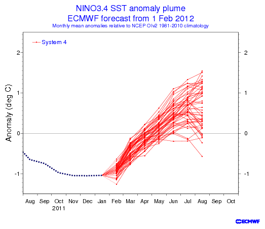
The majority of the ECMWF Ensembles are forecasting a weak El Nino come July and August.

Image


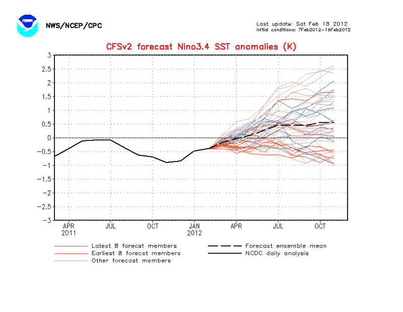
Same goes for the CFSv2
Image
0 likes   
The following post is NOT an official forecast and should not be used as such. It is just the opinion of the poster and may or may not be backed by sound meteorological data. It is NOT endorsed by any professional institution including storm2k.org For Official Information please refer to the NHC and NWS products.

User avatar
bg1
Category 1
Category 1
Posts: 409
Joined: Fri May 13, 2011 11:14 am
Location: near Santee, SC

Re: ENSO Updates

#1856 Postby bg1 » Sat Feb 18, 2012 12:23 pm

Isn't this the time of year where models are least reliable?
0 likes   

User avatar
cycloneye
Admin
Admin
Posts: 145296
Age: 68
Joined: Thu Oct 10, 2002 10:54 am
Location: San Juan, Puerto Rico

Re: ENSO Updates

#1857 Postby cycloneye » Sat Feb 18, 2012 12:42 pm

:uarrow: bg1,that is correct as is during the months between March and May that is the barrier by the models to not be so reliable because of the big changes in the Pacific that occur during that period.

On another topic,I wonder if maybe a Nino Modoki like in 2004 comes into play this year? Nino 3.4 (Between 140W and 170W) stays cold but areas 1-2 and 3 (East of 140W to South America) warm above +0.5C.

Image

Uploaded with ImageShack.us
0 likes   
Visit the Caribbean-Central America Weather Thread where you can find at first post web cams,radars
and observations from Caribbean basin members Click Here

User avatar
Cyclenall
Category 5
Category 5
Posts: 6666
Joined: Thu Jun 08, 2006 10:01 pm
Location: Ontario, Canada

Re: ENSO=CPC February update=Neutral conditions by March-May

#1858 Postby Cyclenall » Mon Feb 20, 2012 5:46 pm

cycloneye wrote:Climate Prediction Center 2/13/12 Weekly update

As I suspected,the warming in the Pacific is evident and this update confirms that as Nino 3.4 warmed up to -1.0C,up from -1.2C of last week's update.

*cut*

That absolutely sucks. This is the worst news of the week. I take it these updates come out every Monday so is there a new one now? I'll check.
0 likes   

User avatar
cycloneye
Admin
Admin
Posts: 145296
Age: 68
Joined: Thu Oct 10, 2002 10:54 am
Location: San Juan, Puerto Rico

Re: ENSO=CPC February update=Neutral conditions by March-May

#1859 Postby cycloneye » Mon Feb 20, 2012 6:09 pm

Cyclenall wrote:
cycloneye wrote:Climate Prediction Center 2/13/12 Weekly update

As I suspected,the warming in the Pacific is evident and this update confirms that as Nino 3.4 warmed up to -1.0C,up from -1.2C of last week's update.

*cut*

That absolutely sucks. This is the worst news of the week. I take it these updates come out every Monday so is there a new one now? I'll check.


None today because of the Presidents Day holiday. The CPC update will be released on Tuesday.
0 likes   
Visit the Caribbean-Central America Weather Thread where you can find at first post web cams,radars
and observations from Caribbean basin members Click Here

User avatar
cycloneye
Admin
Admin
Posts: 145296
Age: 68
Joined: Thu Oct 10, 2002 10:54 am
Location: San Juan, Puerto Rico

Re: ENSO=Breaking News=CPC 2/21/12 update=Nino 3.4 warms to -0.6

#1860 Postby cycloneye » Tue Feb 21, 2012 12:06 pm

Climate Prediction Center 2/21/12 Weekly update

All the ENSO regions warmed sustancially with Nino 3.4 up to -0.6C,warmer than the -1.0C that last week's update brought. In fact,Nino 1-2 close to South America is now in positive territory (+0.9C) This shows how La Nina is fading fast and Neutral ENSO will come in short order. The big question is if is going to warm even more and more to jump towards El Nino in a hurry.

Cyclenall,what do you think of this rapid big jump of the Pacific in general to a much warmer status?

http://www.cpc.ncep.noaa.gov/products/a ... ts-web.pdf

Image
0 likes   
Visit the Caribbean-Central America Weather Thread where you can find at first post web cams,radars
and observations from Caribbean basin members Click Here


Return to “Talkin' Tropics”

Who is online

Users browsing this forum: No registered users and 31 guests