Texas Winter 2011-2012...

Winter Weather Discussion

Moderator: S2k Moderators

Forum rules

The posts in this forum are NOT official forecast and should not be used as such. They are just the opinion of the poster and may or may not be backed by sound meteorological data. They are NOT endorsed by any professional institution or STORM2K.

Help Support Storm2K
Message
Author
User avatar
Ntxw
Storm2k Moderator
Storm2k Moderator
Posts: 22785
Joined: Wed Oct 21, 2009 6:34 pm
Location: DFW, Texas

Re: Texas Winter 2011-2012...

#2741 Postby Ntxw » Sat Feb 11, 2012 4:10 pm

^ Euro depicted that as well. Brief but there nonetheless!

FW is slowly biting into the potential event, gradually changing their forecast towards favorable.

AREA FORECAST DISCUSSION
NATIONAL WEATHER SERVICE FORT WORTH TX
242 PM CST SAT FEB 11 2012

.DISCUSSION...
...A WINTRY MIX OF RAIN...SLEET...AND POSSIBLY SNOW EXPECTED
NORTHWEST OF A COMANCHE...CLEBURNE...DALLAS...EMORY LINE LATE
SUNDAY INTO EARLY MONDAY MORNING...

WATCHING TWO SYSTEMS ON WATER VAPOR SATELLITE WELL TO OUR WEST
THIS AFTERNOON OVER CA/NV AND BAJA MEXICO. THE ARCTIC AIRMASS
CURRENTLY PLACE WILL NOT MODIFY MUCH THROUGH SUNDAY...AS THE CA/NV
DISTURBANCE ABSORBS THE MEXICO DISTURBANCE BY SUNDAY MORNING. THE
DISTURBANCE THEN WILL PROCEED TO INDUCE TOP-DOWN SATURATION AND
WET-BULB COOLING ACROSS WEST TEXAS AND THE HILL COUNTRY BY SUNDAY
AFTERNOON WITH INCREASING CLOUDS AND HIGH TEMPERATURES STRUGGLING
INTO THE 30S AND POSSIBLY LOWER 40S ACROSS THE SOUTHEAST CWA.
ENOUGH SATURATION MAY LEND TO SOME VERY LIGHT RAIN...SLEET OR SNOW
ACROSS THE HIGHER TERRAIN OF WESTERN NORTH TEXAS LATE IN THE DAY.

ISENTROPIC ASCENT AND LIFT WILL INCREASE FROM WEST TO EAST SUNDAY
NIGHT INTO MONDAY MORNING. MODELS DIFFER ON SOUNDING PROFILES WITH
THE NAM12 COLDER THAN THE GFS40 AND THE ECMWF KIND OF IN BETWEEN
ACROSS THE NORTHWEST HALF OF THE AREA. THAT BEING SAID...PARTIAL
THICKNESS METHODS DIFFER MORE THAN THE SOUNDINGS. TO SAY THERE IS
UNCERTAINTY ON EVOLUTION...TYPES OF PRECIPITATION AND AMOUNTS IS
AN UNDERSTATEMENT THIS AFTERNOON. WE WILL TAKE THE MIDDLE OF THE
ROAD APPROACH AT THIS TIME AND TAKE THE WINTRY MIX LINE DOWN TO A
COMANCHE...DALLAS...EMORY LINE. THIS LINE MAY BE ADJUSTED BACK
NORTH OR SOUTH DEPENDING ON FUTURE MODEL RUNS AND ATMOSPHERIC
CHANGES WITH THE THERMAL PROFILE AND LOW LEVEL TEMPERATURES.

STRONG WAA KICKS IN THROUGH 800MB BY MID MORNING MONDAY AND EXPECT
ANY THREAT FOR WINTER PRECIPITATION TO SHIFT NORTH AND EAST OF
NORTH TEXAS. WILL MAINTAIN A MIX FOR MONDAY MORNING ACROSS NORTHEAST
PARTS OF NORTH TEXAS...THEN JUST RAIN AND ISOLATED THUNDERSTORMS
BY AFTERNOON ACROSS THE EASTERN HALF WITH THE PASSAGE OF OUR UPPER
DISTURBANCE.


Image

Uploaded with ImageShack.us
0 likes   
The above post and any post by Ntxw is NOT an official forecast and should not be used as such. It is just the opinion of the poster and may or may not be backed by sound meteorological data. It is NOT endorsed by any professional institution including Storm2k. For official information, please refer to NWS products.

  Help support Storm2K!
Help Support Storm2K

User avatar
srainhoutx
S2K Supporter
S2K Supporter
Posts: 6919
Age: 67
Joined: Sun Jan 14, 2007 11:34 am
Location: Haywood County, NC
Contact:

Re: Texas Winter 2011-2012...

#2742 Postby srainhoutx » Sat Feb 11, 2012 4:19 pm

Portastorm wrote:Late this morning, NWSFO Austin/San Antonio was considering hoisting a Winter Weather Advisory for the Hill Country and adjacent portions of south central Texas for Sunday morning. Main impact would be some very light accumulations on elevated surfaces/bridges. Will be interesting to see if they follow suite later today.

I like those model trends, Ntxw! :cheesy:


:ggreen:

URGENT - WINTER WEATHER MESSAGE
NATIONAL WEATHER SERVICE AUSTIN/SAN ANTONIO TX
314 PM CST SAT FEB 11 2012

...A WINTER WEATHER ADVISORY HAD BEEN ISSUED FOR THE HILL COUNTRY
AND ADJACENT AREAS OF SOUTH CENTRAL TEXAS FROM 6 AM TO NOON SUNDAY...

.COLD DRY AIR CONTINUED TO PUSH INTO SOUTH CENTRAL TEXAS THIS
AFTERNOON...AND WILL CONTINUE TO FILTER INTO THE AREA OVERNIGHT.
MEANWHILE AN APPROACHING UPPER AIR TROUGH WILL BRING PACIFIC
MOISTURE ACROSS MEXICO INTO SOUTH TEXAS...RESULTING IN INCREASING
PRECIPITATION CHANCES FROM THE WEST LATE TONIGHT INTO SUNDAY. WITH
THE COLD AIR IN PLACE...THE PRECIPITATION WILL FALL THROUGH THE
COLD DRY AIRMASS. THERE IS GOOD POTENTIAL FOR THE PRECIPITATION TO
FORM INTO A MIXTURE OF LIGHT RAIN...SLEET AND EVEN LIGHT SNOW.
THIS WINTRY MIX COULD RESULT IN LIGHT ACCUMULATIONS OF ICE MAINLY
ON BRIDGES AND OVERPASSES SUNDAY MORNING ACROSS THE HILL COUNTRY.
SOME HIGHER ELEVATIONS OF THE COUNTIES ADJACENT TO THE HILL
COUNTRY COULD SEE SOME SPOTTY LIGHT ICING ON ELEVATED ROADS AS
WELL. TEMPERATURES ARE EXPECTED TO WARM ABOVE FREEZING BY THE
AFTERNOON WITH WINTRY MIX CHANGING TO RAIN.


TXZ171>173-183>192-202>206-120500-
/O.NEW.KEWX.WW.Y.0001.120212T1200Z-120212T1800Z/
LLANO-BURNET-WILLIAMSON-VAL VERDE-EDWARDS-REAL-KERR-BANDERA-
GILLESPIE-KENDALL-BLANCO-HAYS-TRAVIS-KINNEY-UVALDE-MEDINA-BEXAR-
COMAL-
INCLUDING THE CITIES OF...LLANO...BURNET...GEORGETOWN...DEL RIO...
ROCKSPRINGS...LEAKEY...KERRVILLE...BANDERA...FREDERICKSBURG...
BOERNE...BLANCO...SAN MARCOS...AUSTIN...BRACKETTVILLE...UVALDE...
HONDO...SAN ANTONIO...NEW BRAUNFELS
314 PM CST SAT FEB 11 2012

...WINTER WEATHER ADVISORY IN EFFECT FROM 6 AM TO NOON CST
SUNDAY...

THE NATIONAL WEATHER SERVICE IN AUSTIN/SAN ANTONIO HAS ISSUED A
WINTER WEATHER ADVISORY FOR A WINTRY MIX OF PRECIPITATION WHICH IS
IN EFFECT FROM 6 AM TO NOON CST SUNDAY.

* TIMING...6 AM TO NOON.

* MAIN IMPACT...MOTORISTS ENCOUNTERING SLIPPY ICE ON BRIDGES AND
OVERPASSES.

* OTHER IMPACTS...WIND CHILLS 20 TO 25 DEGREES.
0 likes   
Carla/Alicia/Jerry(In The Eye)/Michelle/Charley/Ivan/Dennis/Katrina/Rita/Wilma/Ike/Harvey

Member: National Weather Association
Wx Infinity Forums
http://wxinfinity.com/index.php

Facebook.com/WeatherInfinity
Twitter @WeatherInfinity

User avatar
Tireman4
S2K Supporter
S2K Supporter
Posts: 5853
Age: 59
Joined: Fri Jun 30, 2006 1:08 pm
Location: Humble, Texas
Contact:

#2743 Postby Tireman4 » Sat Feb 11, 2012 4:22 pm

And just cold rain for Houston.....ahhh...winter...LOL
0 likes   

orangeblood
S2K Supporter
S2K Supporter
Posts: 3714
Joined: Tue Dec 15, 2009 6:14 pm
Location: Fort Worth, TX

Re: Texas Winter 2011-2012...

#2744 Postby orangeblood » Sat Feb 11, 2012 5:14 pm

I know everyone is more concerned about the short term but has anyone checked out the Euro and Japanese models for next Friday?...with the MJO coming around into Phase 1, that system has the potential to dig even further south than what those models are currently showing.
0 likes   

User avatar
Ntxw
Storm2k Moderator
Storm2k Moderator
Posts: 22785
Joined: Wed Oct 21, 2009 6:34 pm
Location: DFW, Texas

Re: Texas Winter 2011-2012...

#2745 Postby Ntxw » Sat Feb 11, 2012 5:33 pm

^ Something to keep in the back of our heads as we sink into the models this evening :)

For Kelarie and Aggiecutter

URGENT - WINTER WEATHER MESSAGE
NATIONAL WEATHER SERVICE SHREVEPORT LA
425 PM CST SAT FEB 11 2012

...A WINTER STORM WATCH IS IN EFFECT FROM LATE SUNDAY NIGHT
THROUGH MONDAY MORNING FOR PORTIONS OF EXTREME NORTHEAST
TEXAS...SOUTHWEST ARKANSAS...AND SOUTHEAST OKLAHOMA...

ARZ050-051-059>061-070-071-OKZ077-TXZ096-097-120500-
/O.NEW.KSHV.WS.A.0001.120213T0600Z-120213T1800Z/
SEVIER-HOWARD-LITTLE RIVER-HEMPSTEAD-NEVADA-MILLER-LAFAYETTE-
MCCURTAIN-RED RIVER-BOWIE-
INCLUDING THE CITIES OF...DE QUEEN...NASHVILLE...ASHDOWN...HOPE...
PRESCOTT...TEXARKANA...LEWISVILLE...IDABEL...CLARKSVILLE
425 PM CST SAT FEB 11 2012

...WINTER STORM WATCH IN EFFECT FROM LATE SUNDAY NIGHT THROUGH
MONDAY MORNING...

THE NATIONAL WEATHER SERVICE IN SHREVEPORT HAS ISSUED A WINTER
STORM WATCH...WHICH IS IN EFFECT FROM LATE SUNDAY NIGHT THROUGH
MONDAY MORNING.

* EVENT...A WINTRY MIX OF FREEZING RAIN...SLEET...AND SNOW WILL
BEGIN TO SPREAD NORTHEAST ACROSS EXTREME NORTHEAST
TEXAS...SOUTHEAST OKLAHOMA...AND PORTIONS OF SOUTHWEST ARKANSAS
LATE SUNDAY NIGHT...AHEAD OF AN UPPER LEVEL DISTURBANCE THAT
WILL APPROACH THE REGION FROM THE WEST. ICE ACCUMULATIONS NEAR
ONE QUARTER OF AN INCH WILL BE POSSIBLE...ESPECIALLY ACROSS
SOUTHEAST OKLAHOMA AND THE NORTHERN SECTIONS OF SOUTHWEST
ARKANSAS. SNOW ACCUMULATIONS OF ONE HALF TO ONE INCH WILL BE
POSSIBLE AS WELL ACROSS NORTHERN MCCURTAIN COUNTY OKLAHOMA AND
PORTIONS OF SOUTHWEST ARKANSAS...MAINLY NORTH OF A BROKEN BOW
OKLAHOMA...TO DEQUEEN AND NASHVILLE ARKANSAS LINE.

* TIMING...ACCUMULATING FREEZING RAIN...SLEET...AND SNOW WILL FALL
AFTER MIDNIGHT SUNDAY NIGHT THROUGH MUCH OF MONDAY MORNING
BEFORE SURFACE TEMPERATURES RISE ABOVE FREEZING AROUND MIDDAY MONDAY.

* IMPACT...POTENTIALLY SIGNIFICANT ICE ACCUMULATIONS COULD OCCUR
ON ELEVATED OBJECTS SUCH AS BRIDGES AND OVERPASSES...TREES AND
POWER LINES. THIS COULD RESULT IN DANGEROUS TRAVEL CONDITIONS...AND
COULD LEAD TO POWER OUTAGES.


PRECAUTIONARY/PREPAREDNESS ACTIONS...

A WINTER STORM WATCH MEANS THERE IS A POTENTIAL FOR SIGNIFICANT
SNOW...SLEET...OR ICE ACCUMULATIONS THAT MAY IMPACT TRAVEL.
CONTINUE TO MONITOR THE LATEST FORECASTS.
0 likes   
The above post and any post by Ntxw is NOT an official forecast and should not be used as such. It is just the opinion of the poster and may or may not be backed by sound meteorological data. It is NOT endorsed by any professional institution including Storm2k. For official information, please refer to NWS products.


  Help support Storm2K!

Help Support Storm2K


aggiecutter
Category 5
Category 5
Posts: 1753
Joined: Thu Oct 14, 2004 9:22 pm
Location: Texarkana

Re: Texas Winter 2011-2012...

#2746 Postby aggiecutter » Sat Feb 11, 2012 5:41 pm

Ntxw wrote:^ Something to keep in the back of our heads as we sink into the models this evening :)

For Kelarie and Aggiecutter

URGENT - WINTER WEATHER MESSAGE
NATIONAL WEATHER SERVICE SHREVEPORT LA
425 PM CST SAT FEB 11 2012

...A WINTER STORM WATCH IS IN EFFECT FROM LATE SUNDAY NIGHT
THROUGH MONDAY MORNING FOR PORTIONS OF EXTREME NORTHEAST
TEXAS...SOUTHWEST ARKANSAS...AND SOUTHEAST OKLAHOMA...

ARZ050-051-059>061-070-071-OKZ077-TXZ096-097-120500-
/O.NEW.KSHV.WS.A.0001.120213T0600Z-120213T1800Z/
SEVIER-HOWARD-LITTLE RIVER-HEMPSTEAD-NEVADA-MILLER-LAFAYETTE-
MCCURTAIN-RED RIVER-BOWIE-
INCLUDING THE CITIES OF...DE QUEEN...NASHVILLE...ASHDOWN...HOPE...
PRESCOTT...TEXARKANA...LEWISVILLE...IDABEL...CLARKSVILLE
425 PM CST SAT FEB 11 2012

...WINTER STORM WATCH IN EFFECT FROM LATE SUNDAY NIGHT THROUGH
MONDAY MORNING...

THE NATIONAL WEATHER SERVICE IN SHREVEPORT HAS ISSUED A WINTER
STORM WATCH...WHICH IS IN EFFECT FROM LATE SUNDAY NIGHT THROUGH
MONDAY MORNING.

* EVENT...A WINTRY MIX OF FREEZING RAIN...SLEET...AND SNOW WILL
BEGIN TO SPREAD NORTHEAST ACROSS EXTREME NORTHEAST
TEXAS...SOUTHEAST OKLAHOMA...AND PORTIONS OF SOUTHWEST ARKANSAS
LATE SUNDAY NIGHT...AHEAD OF AN UPPER LEVEL DISTURBANCE THAT
WILL APPROACH THE REGION FROM THE WEST. ICE ACCUMULATIONS NEAR
ONE QUARTER OF AN INCH WILL BE POSSIBLE...ESPECIALLY ACROSS
SOUTHEAST OKLAHOMA AND THE NORTHERN SECTIONS OF SOUTHWEST
ARKANSAS. SNOW ACCUMULATIONS OF ONE HALF TO ONE INCH WILL BE
POSSIBLE AS WELL ACROSS NORTHERN MCCURTAIN COUNTY OKLAHOMA AND
PORTIONS OF SOUTHWEST ARKANSAS...MAINLY NORTH OF A BROKEN BOW
OKLAHOMA...TO DEQUEEN AND NASHVILLE ARKANSAS LINE.

* TIMING...ACCUMULATING FREEZING RAIN...SLEET...AND SNOW WILL FALL
AFTER MIDNIGHT SUNDAY NIGHT THROUGH MUCH OF MONDAY MORNING
BEFORE SURFACE TEMPERATURES RISE ABOVE FREEZING AROUND MIDDAY MONDAY.

* IMPACT...POTENTIALLY SIGNIFICANT ICE ACCUMULATIONS COULD OCCUR
ON ELEVATED OBJECTS SUCH AS BRIDGES AND OVERPASSES...TREES AND
POWER LINES. THIS COULD RESULT IN DANGEROUS TRAVEL CONDITIONS...AND
COULD LEAD TO POWER OUTAGES.


PRECAUTIONARY/PREPAREDNESS ACTIONS...

A WINTER STORM WATCH MEANS THERE IS A POTENTIAL FOR SIGNIFICANT
SNOW...SLEET...OR ICE ACCUMULATIONS THAT MAY IMPACT TRAVEL.
CONTINUE TO MONITOR THE LATEST FORECASTS.


Yeah, I just saw that. Looks mostly like a sleet-freezing rain event for the Texarkana area, at least for now. One quarter of an inch ice accumulation would cause significant power outages as this area has a lot foliage.
0 likes   

User avatar
Ptarmigan
Category 5
Category 5
Posts: 5313
Joined: Wed Aug 16, 2006 9:06 pm

Re: Texas Winter 2011-2012...

#2747 Postby Ptarmigan » Sat Feb 11, 2012 6:07 pm

orangeblood wrote:I know everyone is more concerned about the short term but has anyone checked out the Euro and Japanese models for next Friday?...with the MJO coming around into Phase 1, that system has the potential to dig even further south than what those models are currently showing.


I looked at the Euro and shows a upper level low pressure west of Texas.
0 likes   

User avatar
Portastorm
Storm2k Moderator
Storm2k Moderator
Posts: 9914
Age: 63
Joined: Fri Jul 11, 2003 9:16 am
Location: Round Rock, TX
Contact:

Re: Texas Winter 2011-2012...

#2748 Postby Portastorm » Sat Feb 11, 2012 6:14 pm

Ptarmigan wrote:
orangeblood wrote:I know everyone is more concerned about the short term but has anyone checked out the Euro and Japanese models for next Friday?...with the MJO coming around into Phase 1, that system has the potential to dig even further south than what those models are currently showing.


I looked at the Euro and shows a upper level low pressure west of Texas.


The next 7-10 days will indeed be very active in Texas and the southern Plains. Whether it is snow or rain or thunder, we've got a number of systems that look to be impacting us in a variety of ways.

The rainfall lately has been great. Just in driving yesterday from Houston to Austin, one could really see a diversity of response from the landscape. A lot of the trees still show a great deal of stress from the drought ... but there is also a lot of greening comng up and some of the grasses are green and luxuriant like an Irish Spring commercial.
0 likes   
Any forecasts under my name are to be taken with a grain of salt. Get your best forecasts from the National Weather Service and National Hurricane Center.

Turtle
Category 1
Category 1
Posts: 285
Joined: Wed Jan 20, 2010 9:02 pm
Location: East Texas

Re: Texas Winter 2011-2012...

#2749 Postby Turtle » Sat Feb 11, 2012 6:30 pm

Image

Nothing for me, a few counties south of that watch. :( I hate it lol.
0 likes   

ndale
Category 1
Category 1
Posts: 429
Joined: Tue Dec 29, 2009 11:12 am
Location: Pflugerville/Austin Tx

#2750 Postby ndale » Sat Feb 11, 2012 7:11 pm

If there is any winter precipitation the Austin weather service seems to think we are on the dividing line. The point forecast for locations on the northwest side of the city has snow/sleet while here in Pflugerville we have cold rain. Any thoughts on the situation for our fair city from the PWC?
0 likes   
Any opinions stated are those of an amateur, please take with several grains of salt and for official forecast refer to the National Weather Service.

User avatar
Kelarie
Category 5
Category 5
Posts: 1074
Age: 54
Joined: Mon Dec 20, 2004 1:18 pm
Location: Hobbs, NM

Re: Texas Winter 2011-2012...

#2751 Postby Kelarie » Sat Feb 11, 2012 7:23 pm

It is going to be interesting to see how this all pans out. Figured we would end up with a WSWatch...Now lets see if it changes by tomorrow morning.
0 likes   

User avatar
Portastorm
Storm2k Moderator
Storm2k Moderator
Posts: 9914
Age: 63
Joined: Fri Jul 11, 2003 9:16 am
Location: Round Rock, TX
Contact:

Re:

#2752 Postby Portastorm » Sat Feb 11, 2012 8:08 pm

ndale wrote:If there is any winter precipitation the Austin weather service seems to think we are on the dividing line. The point forecast for locations on the northwest side of the city has snow/sleet while here in Pflugerville we have cold rain. Any thoughts on the situation for our fair city from the PWC?


No -removed- here. Right now, my guess is that the actual metro area doesn't see much in terms of frozen precip. By the time the air column is saturated enough for moisture to reach the ground, I bet the profile will be for all rain. Places like Dripping Springs, Lago Vista, Cedar Park/Leander, maybe up to Georgetown ... they are the best bets for frozen precip.

But the PWC reserves the right to change the forecast based on model runs later and how the actual temp profiles are shaping up. :wink:
0 likes   
Any forecasts under my name are to be taken with a grain of salt. Get your best forecasts from the National Weather Service and National Hurricane Center.

User avatar
wxman57
Moderator-Pro Met
Moderator-Pro Met
Posts: 22979
Age: 67
Joined: Sat Jun 21, 2003 8:06 pm
Location: Houston, TX (southwest)

Re: Texas Winter 2011-2012...

#2753 Postby wxman57 » Sat Feb 11, 2012 8:10 pm

Quite a bit of warm air advection aloft across Texas by noon tomorrow. Looks like some frozen precip possible in west and north Texas, but that's about it. Way too warm aloft in Dallas by Monday morning, and too warm aloft in Austin by mid afternoon tomorrow - before the precip starts.
0 likes   

User avatar
ludosc
Tropical Storm
Tropical Storm
Posts: 161
Age: 40
Joined: Tue Dec 29, 2009 3:44 pm
Location: Midlothian, TX

Re: Texas Winter 2011-2012...

#2754 Postby ludosc » Sat Feb 11, 2012 11:09 pm

WFAA-TV @wfaachannel8 Reply Retweet Favorite · Open
Meteorologist Steve McCauley says North Texas is in for a "very light" accumulation of snow on Sunday night. Watch News 8 at 10 for details!
0 likes   

User avatar
Texas Snowman
Storm2k Moderator
Storm2k Moderator
Posts: 6179
Joined: Fri Jan 25, 2008 11:29 am
Location: Denison, Texas

Re: Texas Winter 2011-2012...

#2755 Postby Texas Snowman » Sat Feb 11, 2012 11:30 pm

wxman57 wrote:Very little of that air will reach us, orangeblood. And still we don't have a single model forecasting any freezing temps across southeast Texas this weekend, just lows into the lower 40s.


NWS Forecast for Houston overnight 2/11/12:

Overnight: Mostly cloudy, with a low around 33. East wind around 10 mph.

:D
0 likes   
The above post and any post by Texas Snowman is NOT an official forecast and should not be used as such. It is just the opinion of the poster and may or may not be backed by sound meteorological data. It is NOT endorsed by any professional institution including storm2k.org. For official information, please refer to NWS products.

User avatar
Rgv20
S2K Supporter
S2K Supporter
Posts: 2466
Age: 38
Joined: Wed Jan 05, 2011 5:42 pm
Location: Edinburg/McAllen Tx

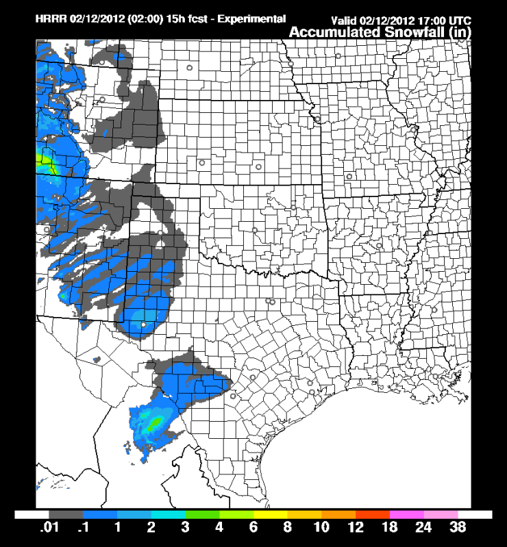
#2756 Postby Rgv20 » Sun Feb 12, 2012 12:24 am

2zHRRR has some light Snowfall accumulations just to the west of San Antonio ending on 11am.

Image
0 likes   
The following post is NOT an official forecast and should not be used as such. It is just the opinion of the poster and may or may not be backed by sound meteorological data. It is NOT endorsed by any professional institution including storm2k.org For Official Information please refer to the NHC and NWS products.

User avatar
hriverajr
Professional-Met
Professional-Met
Posts: 786
Joined: Tue Jul 19, 2005 12:16 am

Re: Texas Winter 2011-2012...

#2757 Postby hriverajr » Sun Feb 12, 2012 7:02 am

It is sleeting in Del Rio
0 likes   

User avatar
hriverajr
Professional-Met
Professional-Met
Posts: 786
Joined: Tue Jul 19, 2005 12:16 am

#2758 Postby hriverajr » Sun Feb 12, 2012 7:31 am

Heavy sleet storm now with perhaps a few snowflakes mixing in... temp is a little high though at around 38
0 likes   

User avatar
TexasF6
S2K Supporter
S2K Supporter
Posts: 816
Joined: Mon Aug 09, 2004 9:33 pm
Location: Austin, TX

Re: Texas Winter 2011-2012...

#2759 Postby TexasF6 » Sun Feb 12, 2012 7:38 am

Looks intense on radar! Any Thundersleet?
0 likes   

User avatar
hriverajr
Professional-Met
Professional-Met
Posts: 786
Joined: Tue Jul 19, 2005 12:16 am

Re: Texas Winter 2011-2012...

#2760 Postby hriverajr » Sun Feb 12, 2012 7:38 am

Nope.. was looking for that but no..
0 likes   


Return to “Winter Weather”

Who is online

Users browsing this forum: No registered users and 30 guests