LLC Developing just East of Belize?? (Is invest 94L)
Moderator: S2k Moderators
Forum rules

The posts in this forum are NOT official forecasts and should not be used as such. They are just the opinion of the poster and may or may not be backed by sound meteorological data. They are NOT endorsed by any professional institution or STORM2K. For official information, please refer to products from the National Hurricane Center and National Weather Service.
-
Hurricane Andrew

- S2K Supporter

- Posts: 1891
- Age: 27
- Joined: Sun May 23, 2010 2:53 pm
- Location: KS
-
Florida1118


Re:
Hurricane Andrew wrote:Where exactly is the low?
I can clearly see a broad circulation with a couple of vorticities, one coming down south along the coast of Belize with the main one near 17.5N & 86W, most of the convection well east of there due to the westerly shear.
0 likes
-
Aric Dunn
- Category 5

- Posts: 21238
- Age: 43
- Joined: Sun Sep 19, 2004 9:58 pm
- Location: Ready for the Chase.
- Contact:
Re: Re:
NDG wrote:Hurricane Andrew wrote:Where exactly is the low?
I can clearly see a broad circulation with a couple of vorticities, one coming down south along the coast of Belize with the main one near 17.5N & 86W, most of the convection well east of there due to the westerly shear.
yeah that one east of belize just developed today. looking at the long loops you can see it. shear is about 30 to 4o kts right now but the models reduce it especially a little farther south just off honduras over the next couple days.
things are improving slowly right about where the surface circ is developing.

0 likes
Note: If I make a post that is brief. Please refer back to previous posts for the analysis or reasoning. I do not re-write/qoute what my initial post said each time.
If there is nothing before... then just ask
Space & Atmospheric Physicist, Embry-Riddle Aeronautical University,
I believe the sky is falling...
If there is nothing before... then just ask
Space & Atmospheric Physicist, Embry-Riddle Aeronautical University,
I believe the sky is falling...
-
northjaxpro

- S2K Supporter
- Posts: 8900
- Joined: Mon Sep 27, 2010 11:21 am
- Location: Jacksonville, FL
18Z TAFB surface analysis has initialized a 1010mb Low pressure on the extreme southern coast of the Yucatan Peninsula near Chetumal, MX.

0 likes
NEVER, EVER SAY NEVER in the tropics and weather in general, and most importantly, with life itself!!
________________________________________________________________________________________
Fay 2008 Beryl 2012 Debby 2012 Colin 2016 Hermine 2016 Julia 2016 Matthew 2016 Irma 2017 Dorian 2019
________________________________________________________________________________________
Fay 2008 Beryl 2012 Debby 2012 Colin 2016 Hermine 2016 Julia 2016 Matthew 2016 Irma 2017 Dorian 2019
-
TropicalAnalystwx13

- Category 5
- Posts: 2109
- Age: 28
- Joined: Tue Jul 19, 2011 8:20 pm
- Location: Wilmington, NC
- Contact:
Re: LLC Developing just East of Belize??
canes04 wrote:Agree,this has got my attention. If shear relaxs it could spin up.
We could have 2 named storms this month.
When was the last time 2 storms formed in May?
1887 is the one and only time 2 tropical storms have formed in May. In 1969 there were two tropical depressions that formed during the month, but neither managed to attain tropical storm status.
0 likes
-
crownweather

- S2K Supporter
- Posts: 602
- Age: 51
- Joined: Sat Aug 12, 2006 9:21 am
- Location: Sturbridge, Massachusetts
- Contact:
Re: LLC Developing just East of Belize??
TropicalAnalystwx13 wrote:canes04 wrote:Agree,this has got my attention. If shear relaxs it could spin up.
We could have 2 named storms this month.
When was the last time 2 storms formed in May?
1887 is the one and only time 2 tropical storms have formed in May. In 1969 there were two tropical depressions that formed during the month, but neither managed to attain tropical storm status.
1887 was a very busy year with 19 storms, 11 hurricanes and 2 major hurricanes. Very busy also with multiple landfalls. http://weather.unisys.com/hurricane/atl ... /index.php .
0 likes
Rob Lightbown
Crown Weather Services
https://crownweather.com
Crown Weather Services
https://crownweather.com

Re: LLC Developing just East of Belize??
Broad circulation near the Yucatan this evening that can be seen on the latest satellite loops.
0 likes
The following post is NOT an official forecast and should not be used as such. It is just the opinion of the poster and may or may not be backed by sound meteorological data. It is NOT endorsed by any professional institution including storm2k.org For Official Information please refer to the NHC and NWS products.
-
northjaxpro
- S2K Supporter
- Posts: 8900
- Joined: Mon Sep 27, 2010 11:21 am
- Location: Jacksonville, FL
HPC 0Z surface analysis shows the 1009 mb Low Pressure area positioned about 100 miles east of Chetumal, MX in the Gulf of Honduras.

0 likes
NEVER, EVER SAY NEVER in the tropics and weather in general, and most importantly, with life itself!!
________________________________________________________________________________________
Fay 2008 Beryl 2012 Debby 2012 Colin 2016 Hermine 2016 Julia 2016 Matthew 2016 Irma 2017 Dorian 2019
________________________________________________________________________________________
Fay 2008 Beryl 2012 Debby 2012 Colin 2016 Hermine 2016 Julia 2016 Matthew 2016 Irma 2017 Dorian 2019
After the Euro doing fairly well with Alberto I am hoping in it being right also with this disturbance. It has being persistent in at least two runs in a row of this disturbance tracking NE towards the Bahamas and western Atlantic then putting the breaks on as ridging builds across the eastern US then retrograde back towards FL bringing much needed rain for central and northern FL and possibly as far north as the GA/Carolinas.
0 likes
-
Aric Dunn
- Category 5
- Posts: 21238
- Age: 43
- Joined: Sun Sep 19, 2004 9:58 pm
- Location: Ready for the Chase.
- Contact:
Re: LLC Developing just East of Belize??
As the models have suggesting the shear in the NW carrib has dropped quite a bit this morning and become more anti cyclonic. we already know there is a low there and convection this morning is a little more concentrated. I would imagine the nhc giving this 20 to 30 % sometime today.
0 likes
Note: If I make a post that is brief. Please refer back to previous posts for the analysis or reasoning. I do not re-write/qoute what my initial post said each time.
If there is nothing before... then just ask
Space & Atmospheric Physicist, Embry-Riddle Aeronautical University,
I believe the sky is falling...
If there is nothing before... then just ask
Space & Atmospheric Physicist, Embry-Riddle Aeronautical University,
I believe the sky is falling...
-
Aric Dunn
- Category 5
- Posts: 21238
- Age: 43
- Joined: Sun Sep 19, 2004 9:58 pm
- Location: Ready for the Chase.
- Contact:
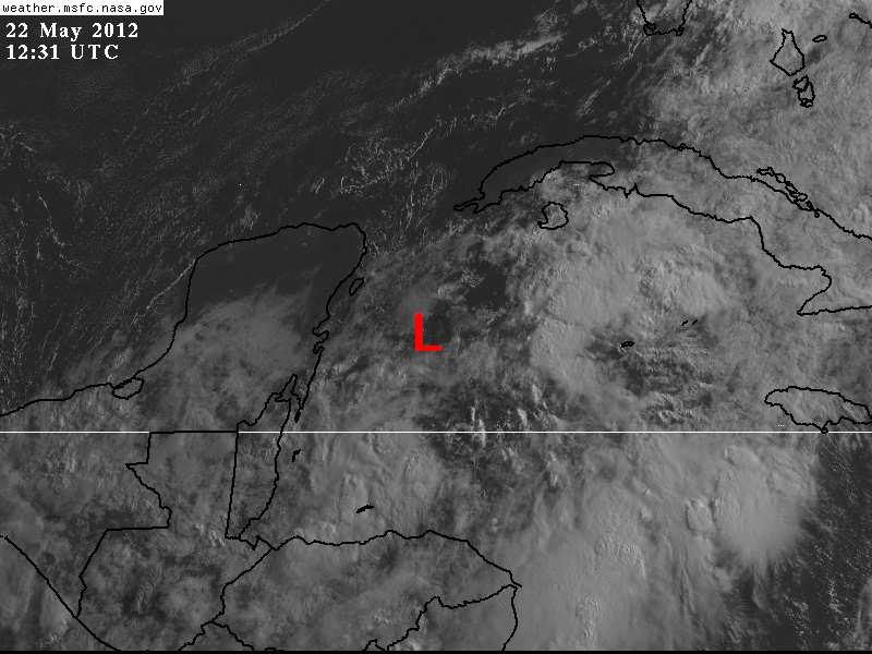
Re:
NDG wrote:I still see the broad surface low, a little further north than yesterday, but no LLC.
It is a bit elongated SW to NE, IMO.
Last night's Euro has a 1005mb closed low this evening near the Isle of Youth, not sure if that will pan out that quick.
[img]http://i20.photobucket.com/albums/b245/ndgarcia/5-22.jpg[/mg]
its still just about where it was yesterday. just north of roatan island. looking at long radar and surface obs you can locate it. there does appear to be another smaller vort up there though.
0 likes
Note: If I make a post that is brief. Please refer back to previous posts for the analysis or reasoning. I do not re-write/qoute what my initial post said each time.
If there is nothing before... then just ask
Space & Atmospheric Physicist, Embry-Riddle Aeronautical University,
I believe the sky is falling...
If there is nothing before... then just ask
Space & Atmospheric Physicist, Embry-Riddle Aeronautical University,
I believe the sky is falling...
-
northjaxpro
- S2K Supporter
- Posts: 8900
- Joined: Mon Sep 27, 2010 11:21 am
- Location: Jacksonville, FL
Yes, the shear is very slowly beginning to slacken in this region. Development will be very gradual, but if the shear can drop to 20 knots or slightly less, this may have a chance to become invest 94L. I think it should get at least a yellow circle from NHC by this evening if the trend continues. The area continues to look better in terms of convection trying to organize around the Low Pressure area. One thing for certain is this has been a very tenacious system. It has festered in this area of the Gulf of Honduras for the past five days.
The posts in this forum are NOT official forecast and should not be used as such. They are just the opinion of the poster and may or may not be backed by sound meteorological data. They are NOT endorsed by any professional institution or storm2k.org. For official information, please refer to the NHC and NWS products.
The posts in this forum are NOT official forecast and should not be used as such. They are just the opinion of the poster and may or may not be backed by sound meteorological data. They are NOT endorsed by any professional institution or storm2k.org. For official information, please refer to the NHC and NWS products.
0 likes
NEVER, EVER SAY NEVER in the tropics and weather in general, and most importantly, with life itself!!
________________________________________________________________________________________
Fay 2008 Beryl 2012 Debby 2012 Colin 2016 Hermine 2016 Julia 2016 Matthew 2016 Irma 2017 Dorian 2019
________________________________________________________________________________________
Fay 2008 Beryl 2012 Debby 2012 Colin 2016 Hermine 2016 Julia 2016 Matthew 2016 Irma 2017 Dorian 2019
Re: Re:
Aric Dunn wrote:NDG wrote:I still see the broad surface low, a little further north than yesterday, but no LLC.
It is a bit elongated SW to NE, IMO.
Last night's Euro has a 1005mb closed low this evening near the Isle of Youth, not sure if that will pan out that quick.
[img]http://i20.photobucket.com/albums/b245/ndgarcia/5-22.jpg[/mg]
its still just about where it was yesterday. just north of roatan island. looking at long radar and surface obs you can locate it. there does appear to be another smaller vort up there though.
IMO, that vorticity that is shown on the radar loop from Belize approaching the Island of Roatan is the vorticity that was coming down on the eastern side of the Yucatan Peninsula rotating around the broader circulation.
I think the circulation that is taking over is to the SE of Cozumel, right about right near buoy 42056, which is reporting some of the lowest pressures in the area, I see lots of SW to NE moving low clouds NE of Roatan.
0 likes
-
Aric Dunn
- Category 5
- Posts: 21238
- Age: 43
- Joined: Sun Sep 19, 2004 9:58 pm
- Location: Ready for the Chase.
- Contact:
Re: Re:
NDG wrote:Aric Dunn wrote:NDG wrote:I still see the broad surface low, a little further north than yesterday, but no LLC.
It is a bit elongated SW to NE, IMO.
Last night's Euro has a 1005mb closed low this evening near the Isle of Youth, not sure if that will pan out that quick.
[img]http://i20.photobucket.com/albums/b245/ndgarcia/5-22.jpg[/mg]
its still just about where it was yesterday. just north of roatan island. looking at long radar and surface obs you can locate it. there does appear to be another smaller vort up there though.
IMO, that vorticity that is shown on the radar loop from Belize approaching the Island of Roatan is the vorticity that was coming down on the eastern side of the Yucatan Peninsula rotating around the broader circulation.
I think the circulation that is taking over is to the SE of Cozumel, right about right near buoy 42056, which is reporting some of the lowest pressures in the area, I see lots of SW to NE moving low clouds NE of Roatan.
well its either way still disorganized and every little burst of convection will pull or for another little vort.
0 likes
Note: If I make a post that is brief. Please refer back to previous posts for the analysis or reasoning. I do not re-write/qoute what my initial post said each time.
If there is nothing before... then just ask
Space & Atmospheric Physicist, Embry-Riddle Aeronautical University,
I believe the sky is falling...
If there is nothing before... then just ask
Space & Atmospheric Physicist, Embry-Riddle Aeronautical University,
I believe the sky is falling...

-
cycloneye

- Admin

- Posts: 149275
- Age: 69
- Joined: Thu Oct 10, 2002 10:54 am
- Location: San Juan, Puerto Rico
Re: LLC Developing just East of Belize??
The 12z surface analysis continues with the low pressure in Western Caribbean.

0 likes
Visit the Caribbean-Central America Weather Thread where you can find at first post web cams,radars
and observations from Caribbean basin members Click Here
and observations from Caribbean basin members Click Here

-
Aric Dunn
- Category 5
- Posts: 21238
- Age: 43
- Joined: Sun Sep 19, 2004 9:58 pm
- Location: Ready for the Chase.
- Contact:
Re:
boca wrote:http://www.ssd.noaa.gov/goes/east/watl/flash-vis.html
I think the low is up by the Isle of Pines
there are multiple vorts. the mean center is our best bet right now... still very broad.
0 likes
Note: If I make a post that is brief. Please refer back to previous posts for the analysis or reasoning. I do not re-write/qoute what my initial post said each time.
If there is nothing before... then just ask
Space & Atmospheric Physicist, Embry-Riddle Aeronautical University,
I believe the sky is falling...
If there is nothing before... then just ask
Space & Atmospheric Physicist, Embry-Riddle Aeronautical University,
I believe the sky is falling...
Who is online
Users browsing this forum: No registered users and 105 guests