EPAC: BUD - Post-Tropical

Moderator: S2k Moderators
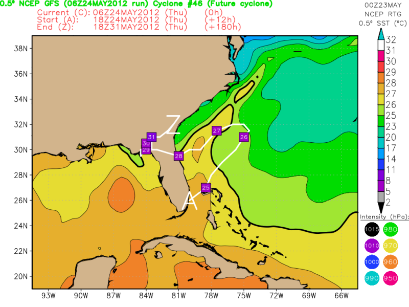
Message
Author
User avatar
Kingarabian
S2K Supporter
S2K Supporter
Posts: 15980
Joined: Sat Aug 08, 2009 3:06 am
Location: Honolulu, Hawaii

#301 Postby Kingarabian » Thu May 24, 2012 4:42 am

Image

Pinhole eye!

Raw T#'s are now @ 5.8.

Could become a major hurricane tomorrow. Recon will have an awesome time tomorrow I'm sure, I hope they stay safe. Night everyone!

I really think it's a Cat. 2 right now:
Image
0 likes   
RIP Kobe Bryant

User avatar
Chacor
Category 5
Category 5
Posts: 10229
Joined: Mon Oct 02, 2006 10:43 pm
Location: Singapore

#302 Postby Chacor » Thu May 24, 2012 4:56 am

Bud is looking very impressive. Can't be too far from Cat 3, even. The next intermediate will be interesting.
0 likes   

AHS2011
Tropical Storm
Tropical Storm
Posts: 134
Joined: Sun Jun 05, 2011 7:39 am

Re: ATL: INVEST 94L - Models

#303 Postby AHS2011 » Thu May 24, 2012 5:06 am

Well, all that we can ***possibly*** conclude is that there will be a retrograding system, most likely tropical, over the holiday weekend. This May may have a repeat of the 1887 season, two pre-season named storms. Alberto....gone-Beryl...coming. What are the chances of a May cat 1 hurricane?
0 likes   
"People might not get all they work for in this world, but they must certainly work for all they get."- Frederick Douglass

xironman
S2K Supporter
S2K Supporter
Posts: 2522
Joined: Sun Jun 10, 2007 4:53 pm
Location: NoVA

Re: ATL: INVEST 94L - Models

#304 Postby xironman » Thu May 24, 2012 5:22 am

boca wrote:
'CaneFreak wrote:I am certainly not drinking the EURO's Koolaid...seems a little too ambitious...I think a track similar to it's solution may be accurate but not in terms of intensity. It is WAY too early for the kind of development that the EURO shows. SSTs in the continental shelf are still in the low to mid 70s. We shall see...


Agreed,If the water temps were in the low to mid 80's maybe.


Usually the upper atmosphere is not as warm this time of year as it is later, so a numerical model could be expressing the convective potential in which both are lower.
0 likes   

User avatar
Cyclenall
Category 5
Category 5
Posts: 6666
Joined: Thu Jun 08, 2006 10:01 pm
Location: Ontario, Canada

Re: EPAC: BUD - Hurricane

#305 Postby Cyclenall » Thu May 24, 2012 6:09 am

Bud is looking amazing now :eek: . He doesn't have a pin-hole eye but the eye is close to clearing out with some frames showing the eye very well. Its possible the hurricane is undergoing explosive intensification but we will have to see if it continues all day.

CI# /Pressure/ Vmax
4.7 / 975.9mb / 82.2kt


Final T# Adj T# Raw T#
4.7 / 4.7 / 5.7

Nearing category 2 strength I think. That raw T# is going nuts. Recon is going to be awesome.
0 likes   

User avatar
cycloneye
Admin
Admin
Posts: 145299
Age: 68
Joined: Thu Oct 10, 2002 10:54 am
Location: San Juan, Puerto Rico

Re: EPAC: BUD - Hurricane

#306 Postby cycloneye » Thu May 24, 2012 6:09 am

Thankfully,the cruise ship Millenium is out of danger as it surpassed Bud in longitude.

http://www.sailwx.info/shiptrack/shippo ... call=9HJF9
0 likes   
Visit the Caribbean-Central America Weather Thread where you can find at first post web cams,radars
and observations from Caribbean basin members Click Here

RL3AO
Moderator-Pro Met
Moderator-Pro Met
Posts: 16308
Joined: Thu Jun 14, 2007 10:03 pm
Location: NC

#307 Postby RL3AO » Thu May 24, 2012 6:37 am

Quick guess would be 90kts are so. Recon might actually fly into an EPAC storm at its peak for once. :lol:
0 likes   

User avatar
TropicalAnalystwx13
Category 5
Category 5
Posts: 2109
Age: 27
Joined: Tue Jul 19, 2011 8:20 pm
Location: Wilmington, NC
Contact:

#308 Postby TropicalAnalystwx13 » Thu May 24, 2012 6:45 am

Image
0 likes   

User avatar
NDG
S2K Supporter
S2K Supporter
Posts: 15446
Joined: Sun Jul 09, 2006 10:14 pm
Location: Orlando, FL

#309 Postby NDG » Thu May 24, 2012 6:45 am

This will definitely be a hybrid/subtropical set up for organization in the beginning. It may gain more subtropical or tropical charecteristics just east of FL as it moves over the gulf stream.

Image
Image
Image
0 likes   

User avatar
cycloneye
Admin
Admin
Posts: 145299
Age: 68
Joined: Thu Oct 10, 2002 10:54 am
Location: San Juan, Puerto Rico

Re: EPAC: BUD-Recon: Plane departs Keesler base at 10:15 AM EDT

#310 Postby cycloneye » Thu May 24, 2012 6:47 am

It will be a long flight but facinating to see when it gets closer to Bud to grasp the data.

gotoman38,or Brunota will be posting the flight from start to finish. :)
0 likes   
Visit the Caribbean-Central America Weather Thread where you can find at first post web cams,radars
and observations from Caribbean basin members Click Here

User avatar
TropicalAnalystwx13
Category 5
Category 5
Posts: 2109
Age: 27
Joined: Tue Jul 19, 2011 8:20 pm
Location: Wilmington, NC
Contact:

#311 Postby TropicalAnalystwx13 » Thu May 24, 2012 6:49 am

BULLETIN
HURRICANE BUD INTERMEDIATE ADVISORY NUMBER 14A
NWS NATIONAL HURRICANE CENTER MIAMI FL EP022012
500 AM PDT THU MAY 24 2012

...BUD STRENGTHENS A LITTLE MORE...


SUMMARY OF 500 AM PDT...1200 UTC...INFORMATION
----------------------------------------------
LOCATION...15.2N 107.0W
ABOUT 315 MI...510 KM SSW OF MANZANILLO MEXICO
ABOUT 370 MI...595 KM SSW OF CABO CORRIENTES MEXICO
MAXIMUM SUSTAINED WINDS...90 MPH...150 KM/H
PRESENT MOVEMENT...NNE OR 20 DEGREES AT 7 MPH...11 KM/H
MINIMUM CENTRAL PRESSURE...978 MB...28.88 INCHES
0 likes   

User avatar
brunota2003
S2K Supporter
S2K Supporter
Posts: 9476
Age: 34
Joined: Sat Jul 30, 2005 9:56 pm
Location: Stanton, KY...formerly Havelock, NC
Contact:

#312 Postby brunota2003 » Thu May 24, 2012 6:52 am

Unfortunately I will be busy all day (on my phone), I will be watching and posting on occasion, but can't actually run the mission
0 likes   
Just a small town southern boy helping other humans.

User avatar
cycloneye
Admin
Admin
Posts: 145299
Age: 68
Joined: Thu Oct 10, 2002 10:54 am
Location: San Juan, Puerto Rico

Re:

#313 Postby cycloneye » Thu May 24, 2012 6:53 am

brunota2003 wrote:Unfortunately I will be busy all day (on my phone), I will be watching and posting on occasion, but can't actually run the mission


Ok no problem.
0 likes   
Visit the Caribbean-Central America Weather Thread where you can find at first post web cams,radars
and observations from Caribbean basin members Click Here

RL3AO
Moderator-Pro Met
Moderator-Pro Met
Posts: 16308
Joined: Thu Jun 14, 2007 10:03 pm
Location: NC

#314 Postby RL3AO » Thu May 24, 2012 6:59 am

Is that a "conservative" 75kts from the NHC?
0 likes   

User avatar
NDG
S2K Supporter
S2K Supporter
Posts: 15446
Joined: Sun Jul 09, 2006 10:14 pm
Location: Orlando, FL

#315 Postby NDG » Thu May 24, 2012 7:19 am

06z gfs's track of the low is very similar to that of last night's 0z euro.

Image

You can see how it has the low as shallow warm core but as it retrogrades towards FL it gains more tropical or subtropical charecteristics as it moves over the gulf stream.

Image
0 likes   

Aric Dunn
Category 5
Category 5
Posts: 21238
Age: 42
Joined: Sun Sep 19, 2004 9:58 pm
Location: Ready for the Chase.
Contact:

#316 Postby Aric Dunn » Thu May 24, 2012 7:34 am

00z ukmet is right there with the Euro on track and intensity.

http://www.meteo.psu.edu/~gadomski/UKTR ... kloop.html
0 likes   
Note: If I make a post that is brief. Please refer back to previous posts for the analysis or reasoning. I do not re-write/qoute what my initial post said each time.
If there is nothing before... then just ask :)

Space & Atmospheric Physicist, Embry-Riddle Aeronautical University,
I believe the sky is falling...

User avatar
cycloneye
Admin
Admin
Posts: 145299
Age: 68
Joined: Thu Oct 10, 2002 10:54 am
Location: San Juan, Puerto Rico

Re: EPAC: BUD - Hurricane

#317 Postby cycloneye » Thu May 24, 2012 7:47 am

12z Best Track-90kts

EP, 02, 2012052412, , BEST, 0, 153N, 1069W, 90, 970, HU

http://ftp.nhc.noaa.gov/atcf/tcweb/inve ... 012.invest
0 likes   
Visit the Caribbean-Central America Weather Thread where you can find at first post web cams,radars
and observations from Caribbean basin members Click Here

RL3AO
Moderator-Pro Met
Moderator-Pro Met
Posts: 16308
Joined: Thu Jun 14, 2007 10:03 pm
Location: NC

#318 Postby RL3AO » Thu May 24, 2012 7:52 am

Alberto was just a warm up for recon. Straight into the fire with this one.
0 likes   

User avatar
gotoman38
Category 5
Category 5
Posts: 1395
Joined: Fri Sep 12, 2003 1:15 pm
Location: near Durham, NC

Re: Re:

#319 Postby gotoman38 » Thu May 24, 2012 8:02 am

cycloneye wrote:
brunota2003 wrote:Unfortunately I will be busy all day (on my phone), I will be watching and posting on occasion, but can't actually run the mission


Ok no problem.


I'm on it - should be able to cover the whole mission minus a few short breaks.
0 likes   

User avatar
cycloneye
Admin
Admin
Posts: 145299
Age: 68
Joined: Thu Oct 10, 2002 10:54 am
Location: San Juan, Puerto Rico

Re: Re:

#320 Postby cycloneye » Thu May 24, 2012 8:03 am

gotoman38 wrote:
cycloneye wrote:
brunota2003 wrote:Unfortunately I will be busy all day (on my phone), I will be watching and posting on occasion, but can't actually run the mission


Ok no problem.


I'm on it - should be able to cover the whole mission minus a few short breaks.


Thank you for that. Let's see how strong Bud really is.
0 likes   
Visit the Caribbean-Central America Weather Thread where you can find at first post web cams,radars
and observations from Caribbean basin members Click Here


Return to “2012”

Who is online

Users browsing this forum: No registered users and 3 guests