Global model runs discussion
Moderator: S2k Moderators
-
Meso

- Category 5

- Posts: 1609
- Age: 39
- Joined: Mon Aug 09, 2004 12:14 pm
- Location: South Africa
- Contact:
Re: Global Model Runs Discussion
Eh, 00z is in line with similar thinking to the previous few runs in that it sees a large area of moisture moving through the western Caribbean near the end of the time frame, where yesterday's run was taking it east of Florida, the 00z shows it headed into the gulf.
0 likes
-
floridasun78
- Category 5
- Posts: 3755
- Joined: Sun May 17, 2009 10:16 pm
- Location: miami fl
Re: Global Model Runs Discussion
Meso wrote:Eh, 00z is in line with similar thinking to the previous few runs in that it sees a large area of moisture moving through the western Caribbean near the end of the time frame, where yesterday's run was taking it east of Florida, the 00z shows it headed into the gulf.
which model you talking about?
0 likes
-
cycloneye

- Admin

- Posts: 149505
- Age: 69
- Joined: Thu Oct 10, 2002 10:54 am
- Location: San Juan, Puerto Rico
Re: Global Model Runs Discussion
floridasun78 wrote:Meso wrote:Eh, 00z is in line with similar thinking to the previous few runs in that it sees a large area of moisture moving through the western Caribbean near the end of the time frame, where yesterday's run was taking it east of Florida, the 00z shows it headed into the gulf.
which model you talking about?
He is talking of GFS.
0 likes
Visit the Caribbean-Central America Weather Thread where you can find at first post web cams,radars
and observations from Caribbean basin members Click Here
and observations from Caribbean basin members Click Here
-
Aric Dunn
- Category 5
- Posts: 21238
- Age: 43
- Joined: Sun Sep 19, 2004 9:58 pm
- Location: Ready for the Chase.
- Contact:
GFS a again showing western carrib and gulf system in long range.
0 likes
Note: If I make a post that is brief. Please refer back to previous posts for the analysis or reasoning. I do not re-write/qoute what my initial post said each time.
If there is nothing before... then just ask
Space & Atmospheric Physicist, Embry-Riddle Aeronautical University,
I believe the sky is falling...
If there is nothing before... then just ask
Space & Atmospheric Physicist, Embry-Riddle Aeronautical University,
I believe the sky is falling...
-
Aric Dunn
- Category 5
- Posts: 21238
- Age: 43
- Joined: Sun Sep 19, 2004 9:58 pm
- Location: Ready for the Chase.
- Contact:
for quite a few runs now the cmc continues to pull something out of the gulf/carrib and races across florida and into the atlantic. this run is much more aggressive.
http://moe.met.fsu.edu/cgi-bin/cmctc2.c ... =Animation
And now the 12z NOGAPS is as well for the first time.
https://www.fnmoc.navy.mil/wxmap_cgi/cg ... t=Tropical
http://moe.met.fsu.edu/cgi-bin/cmctc2.c ... =Animation
And now the 12z NOGAPS is as well for the first time.
https://www.fnmoc.navy.mil/wxmap_cgi/cg ... t=Tropical
0 likes
Note: If I make a post that is brief. Please refer back to previous posts for the analysis or reasoning. I do not re-write/qoute what my initial post said each time.
If there is nothing before... then just ask
Space & Atmospheric Physicist, Embry-Riddle Aeronautical University,
I believe the sky is falling...
If there is nothing before... then just ask
Space & Atmospheric Physicist, Embry-Riddle Aeronautical University,
I believe the sky is falling...

Re: Global Model Runs Discussion
FWIW- noticed the 18Z GFS spit outs a TS at 384hr heading into the GOM. Thats exciting...getting that time of year for the GFS to spin up the storms in the long long range...
0 likes

Re: Global Model Runs Discussion
ROCK wrote:FWIW- noticed the 18Z GFS spit outs a TS at 384hr heading into the GOM. Thats exciting...getting that time of year for the GFS to spin up the storms in the long long range...
Another Allison perhaps........................
0 likes
Re: Global Model Runs Discussion
lets hope not PT.... 
0Z GFS still rolling nada in the short to medium range. Waiting on the long range to see if it kept the storm....
0Z GFS still rolling nada in the short to medium range. Waiting on the long range to see if it kept the storm....
0 likes
Re: Global Model Runs Discussion
in GFS la la land at 336hrs we have a storm moving across the Yuc.....
0 likes
-
Meso
- Category 5
- Posts: 1609
- Age: 39
- Joined: Mon Aug 09, 2004 12:14 pm
- Location: South Africa
- Contact:
Re: Global Model Runs Discussion
Two storms in the 00z GFS.
One forms as it moves NE over Florida, forming a tropical or subtropical storm off the east coast at around 288+- hours. And then it's also continuing to show the one around the gulf/western Caribbean near the end of the run.
One forms as it moves NE over Florida, forming a tropical or subtropical storm off the east coast at around 288+- hours. And then it's also continuing to show the one around the gulf/western Caribbean near the end of the run.
0 likes
-
cycloneye
- Admin
- Posts: 149505
- Age: 69
- Joined: Thu Oct 10, 2002 10:54 am
- Location: San Juan, Puerto Rico
Re: Global Model Runs Discussion
This mornings discussion by Rob of Crown Weather.
The posts in this forum are NOT official forecast and should not be used as such. They are just the opinion of the poster and may or may not be backed by sound meteorological data. They are NOT endorsed by any professional institution or storm2k.org. For official information, please refer to the NHC and NWS products.
http://www.crownweather.com/?page_id=4557
I am seeing signals in both the forecast pattern and in the long-range model guidance that we may have a third tropical cyclone develop by or before June 15th. Last night’s GFS model forecasts the development of two storms in the long range. One storm develops as it tracks away from Florida and into the Atlantic around June 13th and the development of a storm in the western Caribbean and southern Gulf of Mexico around June 15-16th.
First and foremost, I want to say that I am not expecting any tropical development through at least June 10th. After that, however, I think we could see some sort of tropical development in either the extreme northwestern Caribbean or in the Gulf of Mexico as we edge near June 15th.
So, after several days of expected rainfall in the eastern United States from this weekend into early next week, we should see high pressure build into the eastern United States as we get into the middle and later part of next week. This will in turn cause a lowering of barometric pressures in the Caribbean and the southern Gulf of Mexico. This could end up being a long duration development, meaning that development will end up being very slow to take place and may end up taking upwards of a week before something finally pops between June 13th and June 16th.
So, it is entirely conceivable that the GFS model may be onto something in the forecast development in the Gulf of Mexico around June 15th. It should be noted that the GFS model did very well with the development of Beryl over a week out, and the upper level forecast charts for around June 15th show lowering pressures over the Gulf of Mexico. So, this will be something to watch as we get closer in time.
0 likes
Visit the Caribbean-Central America Weather Thread where you can find at first post web cams,radars
and observations from Caribbean basin members Click Here
and observations from Caribbean basin members Click Here
-
Aric Dunn
- Category 5
- Posts: 21238
- Age: 43
- Joined: Sun Sep 19, 2004 9:58 pm
- Location: Ready for the Chase.
- Contact:
12z run shows no system but does however show a very persistent area of convection in the NW carrib and gulf. whats interesting is that it starts to fester around 120 hrs after a system heads of the east coast. seems to be the tail end of a front that stalls in the area and a series of weak troughs reinforce it through the rest of the run. its very similar to the 00z run in that it keeps the disturbed weather around in the area for over a week after about 120 hours spinning off multiple lows. may point to take from it is that something will likely be there to watch and like crown weather said as well .... its likely going to be a very slow process.
0 likes
Note: If I make a post that is brief. Please refer back to previous posts for the analysis or reasoning. I do not re-write/qoute what my initial post said each time.
If there is nothing before... then just ask
Space & Atmospheric Physicist, Embry-Riddle Aeronautical University,
I believe the sky is falling...
If there is nothing before... then just ask
Space & Atmospheric Physicist, Embry-Riddle Aeronautical University,
I believe the sky is falling...
-
SEASON_CANCELED

- Category 3

- Posts: 887
- Joined: Mon Jul 06, 2009 5:17 am
- Location: 8 Bit Charlie Sheen
Re: Global Model Runs Discussion
GFS Hinting at something next tuesday. But its sporadic with each run. Not sure what to make of it. CMC caught it also. Will see.
0 likes
i am a big stupid ugly moron with an ugly face and a big butt and my butt stinks and i like to kiss my own butt

-
cycloneye
- Admin
- Posts: 149505
- Age: 69
- Joined: Thu Oct 10, 2002 10:54 am
- Location: San Juan, Puerto Rico
Re: Global Model Runs Discussion
Once again, another GFS run (12z) shows the Western Caribbean system. But is very long range and for sure as the runs come,the scenario changes. Let's see if other models join GFS later on in the next few days or this is a ghost.

Uploaded with imageshack.us
Uploaded with imageshack.us
0 likes
Visit the Caribbean-Central America Weather Thread where you can find at first post web cams,radars
and observations from Caribbean basin members Click Here
and observations from Caribbean basin members Click Here

Re: Global Model Runs Discussion

12z Euro. Now this is what you call homebrew...this does not originate from the tropics, but from the CONUS. It dips into the water from the NGOM, tracks across FL, and then off the East Coast.
Heading is about NNE from hr 216-240
0 likes
-
cycloneye
- Admin
- Posts: 149505
- Age: 69
- Joined: Thu Oct 10, 2002 10:54 am
- Location: San Juan, Puerto Rico
Re: Global Model Runs Discussion
The 00z runs didn't offer hope for something to develop anytime soon as the GFS and ECMWF are distant from a consensus. Imagine that what ECMWF had off the East coast of U.S on Saturdays runs,is not there at 00z and that says it all.
0 likes
Visit the Caribbean-Central America Weather Thread where you can find at first post web cams,radars
and observations from Caribbean basin members Click Here
and observations from Caribbean basin members Click Here
-
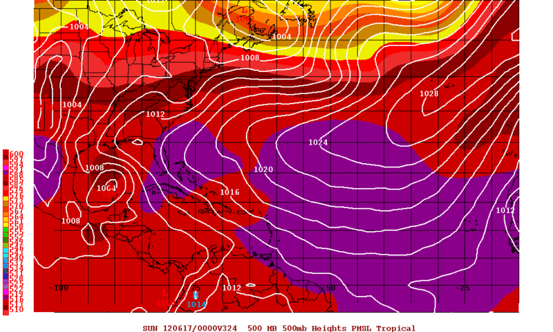
Rgv20

- S2K Supporter

- Posts: 2466
- Age: 39
- Joined: Wed Jan 05, 2011 5:42 pm
- Location: Edinburg/McAllen Tx
12zGFS has a tropical system in the GOM in the Loonngg Range...324hrs out.
0 likes
The following post is NOT an official forecast and should not be used as such. It is just the opinion of the poster and may or may not be backed by sound meteorological data. It is NOT endorsed by any professional institution including storm2k.org For Official Information please refer to the NHC and NWS products.
Re: Global Model Runs Discussion
12Z GFS shows some stormy weather at 288HR for folks in LA....looks like a weak TS...but it is a long way away to get all worked up over....
0 likes
Who is online
Users browsing this forum: No registered users and 59 guests