ENSO Updates (2007 thru 2023)
Moderator: S2k Moderators
Forum rules

The posts in this forum are NOT official forecasts and should not be used as such. They are just the opinion of the poster and may or may not be backed by sound meteorological data. They are NOT endorsed by any professional institution or STORM2K. For official information, please refer to products from the National Hurricane Center and National Weather Service.
-
euro6208
Re: ENSO Updates: 30 day SOI Index is down to -8.5
tropical hell in the pacific!!! elnino is coming!
0 likes


-
SaskatchewanScreamer
-
joshb19882004
- Tropical Low

- Posts: 23
- Joined: Thu Apr 05, 2012 10:10 am
Re: ENSO Updates: 30 day SOI Index is down to -8.5
texas needs el nino to kick in its dry still here
0 likes
-
weatherdude1108
- Category 5

- Posts: 4228
- Joined: Tue Dec 13, 2011 1:04 pm
- Location: Northwest Austin/Cedar Park, TX
Re: ENSO Updates: 30 day SOI Index is down to -8.5
joshb19882004 wrote:texas needs el nino to kick in its dry still here
Yes! We definitely need it to kick in this part of Texas! Our reservoirs (Travis and Buchanan) are 51% full (or 49% empty) depending on how you look at it. I think the last time both were completely full at the same time was back in 2007(?).
0 likes
The preceding post is NOT an official forecast, and should not be used as such. It is only the opinion of the poster and may or may not be backed by sound meteorological data. It is NOT endorsed by any professional institution including storm2k.org. For Official Information please refer to the NHC and NWS products.
-
cycloneye

- Admin

- Posts: 149476
- Age: 69
- Joined: Thu Oct 10, 2002 10:54 am
- Location: San Juan, Puerto Rico
Re: ENSO Updates: 30 day SOI Index is down to -8.5
weatherdude1108 wrote:joshb19882004 wrote:texas needs el nino to kick in its dry still here
Yes! We definitely need it to kick in this part of Texas! Our reservoirs (Travis and Buchanan) are 51% full (or 49% empty) depending on how you look at it. I think the last time both were completely full at the same time was back in 2007(?).
Texas also needs a good solid winter as the last 2011-2012 one was lackluster for that state.If El Nino kicks in,then Texas will have a good winter. We have a Texas Winter 2012-2013 thread for the folks who live in Texas.
viewtopic.php?f=22&p=2228518#p2228518
0 likes
Visit the Caribbean-Central America Weather Thread where you can find at first post web cams,radars
and observations from Caribbean basin members Click Here
and observations from Caribbean basin members Click Here


The latest MJO/Kelvin wave is entering the western hemisphere (EPAC) hence the activity brewing there. This will probably allow the SOI to relax for awhile from such negative values. However I think the damage may have already been done to nino 3-3.4. Next week's update should be reflective of the warming due to the bursts of westerlies this week.

I made this post for the new month on June 1st. The models were correct in awakening the MJO. Now just need the other half to verify.
I made this post for the new month on June 1st. The models were correct in awakening the MJO. Now just need the other half to verify.
Ntxw wrote:Ok lets try this one more time. Should take this with a grain of salt given the lack of verification in May. The key players (Ukmet, Euro) are indicating a significant awakening of the MJO/Kelvin wave by the summer solstice. Meanwhile the PDO index has been rising since slightly since March. Back in late feb or early march I predicted El nino to arrive by mid June, 2 weeks to go to have that verify.
0 likes
The above post and any post by Ntxw is NOT an official forecast and should not be used as such. It is just the opinion of the poster and may or may not be backed by sound meteorological data. It is NOT endorsed by any professional institution including Storm2k. For official information, please refer to NWS products.
Help support Storm2K!

Re: ENSO Updates
I was trying to find ENSO data going back before 1950 on what the phase was and how strong. I then looked at some SOI data going back to the 1800s as a sub but I heard that it can wildly show values not corresponding to what the ENSO state is in. I want to know as much as possible about 1911 and based on the SOI trend, It might have been neutral conditions going into a moderate El Nino during the course of the year. 1905 looked like a very strong El Nino but this is a guess. Any take on where to find the experts analysis on ENSO states before 1950? 1911 specifically.
0 likes
Personally I think that it will be hard for the SOI to tank any lower than what it is right now with surface pressures forecasted to stay somewhat high in Tahiti.
No signs of any westerly winds taking over the central Pacific any time soon, so I think that if we see Nino 3.4 getting up to El Nino will not be until at least September.
No signs of any westerly winds taking over the central Pacific any time soon, so I think that if we see Nino 3.4 getting up to El Nino will not be until at least September.
0 likes

Re: ENSO Updates
Cyclenall wrote:I was trying to find ENSO data going back before 1950 on what the phase was and how strong. I then looked at some SOI data going back to the 1800s as a sub but I heard that it can wildly show values not corresponding to what the ENSO state is in. I want to know as much as possible about 1911 and based on the SOI trend, It might have been neutral conditions going into a moderate El Nino during the course of the year. 1905 looked like a very strong El Nino but this is a guess. Any take on where to find the experts analysis on ENSO states before 1950? 1911 specifically.
Winter of 1904-1905 was El Nino, the previous winter was La Nina. It was one of the coldest winters on record. Also, 1911-1912 was El Nino. Like 1904, 1911 went from La Nina to El Nino.
Here are some ENSO data.
TNI (Trans-Niño Index) and N3.4 (Niño 3.4 Index)
http://www.cgd.ucar.edu/cas/catalog/cli ... index.html
Japanese Meteorological Agency ENSO
ftp://www.coaps.fsu.edu/pub/JMA_SST_Ind ... y.filter-5
Hope it helps.
0 likes
-
Yellow Evan

- Professional-Met

- Posts: 16240
- Age: 27
- Joined: Fri Jul 15, 2011 12:48 pm
- Location: Henderson, Nevada/Honolulu, HI
- Contact:
Re:
NDG wrote:Personally I think that it will be hard for the SOI to tank any lower than what it is right now with surface pressures forecasted to stay somewhat high in Tahiti.
No signs of any westerly winds taking over the central Pacific any time soon, so I think that if we see Nino 3.4 getting up to El Nino will not be until at least September.
MJO is coming, so that should help. El Nino looks likely very soon IMO.
The posts in this forum are NOT official forecast and should not be used as such. They are just the opinion of the poster and may or may not be backed by sound meteorological data. They are NOT endorsed by any professional institution or storm2k.org. For official information, please refer to the NHC and NWS products.
0 likes
Re: ENSO Updates
Ptarmigan wrote:
Winter of 1904-1905 was El Nino, the previous winter was La Nina. It was one of the coldest winters on record. Also, 1911-1912 was El Nino. Like 1904, 1911 went from La Nina to El Nino.
Here are some ENSO data.
TNI (Trans-Niño Index) and N3.4 (Niño 3.4 Index)
http://www.cgd.ucar.edu/cas/catalog/cli ... index.html
Japanese Meteorological Agency ENSO
ftp://www.coaps.fsu.edu/pub/JMA_SST_Ind ... y.filter-5
Hope it helps.
Yes that does help, thanks. The 2nd link had data I could read more into to see ENSO trends. Now knowing 1911 went from La Nina to El Nino is tantalizing since that is very similar to what might be going on now. I think the La Nina at the start of 1911 was stronger than now but when May's temperatures went berserk around here a major shift was occurring at that time. 1911 has been fascinating me because of the insane heat from May to September IMBY and now I know the first piece of the puzzle.
Here is a data row from the Joint Institute for the Study of the Atmosphere and Ocean Wesbite:
Eastern Equatorial Pacific Sea Surface Temperature Anomalies (ºC) also known as the "cold tongue index" (CTI). CTI values in hundredths ºC. For example, 62 is 0.62 ºC:
1911 -48 -61 -49 -32 52 37 118 123 131 133 181 225
0 likes
Re: Re:
Yellow Evan wrote:NDG wrote:Personally I think that it will be hard for the SOI to tank any lower than what it is right now with surface pressures forecasted to stay somewhat high in Tahiti.
No signs of any westerly winds taking over the central Pacific any time soon, so I think that if we see Nino 3.4 getting up to El Nino will not be until at least September.
MJO is coming, so that should help. El Nino looks likely very soon IMO.
The posts in this forum are NOT official forecast and should not be used as such. They are just the opinion of the poster and may or may not be backed by sound meteorological data. They are NOT endorsed by any professional institution or storm2k.org. For official information, please refer to the NHC and NWS products.
MJO is already approaching the eastern Pacific, looks like it is affecting Nino 3 Region more than Nino 3.4 & 4 Regions, but nonetheless still a nice little warm up during this week.

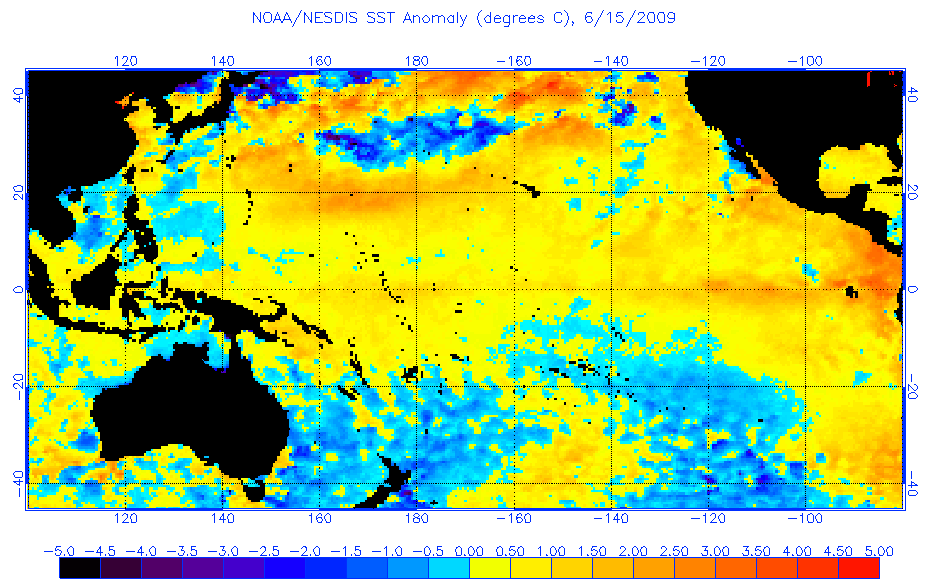
Look at 2009 by this same time of year, glad people have dropped the idea lately of 2009 being an ENSO analog year.
0 likes
-
cycloneye
- Admin
- Posts: 149476
- Age: 69
- Joined: Thu Oct 10, 2002 10:54 am
- Location: San Juan, Puerto Rico
Re: ENSO Updates
The June ECMWF update shows Weak to Moderate El Nino for August/September/October.

0 likes
Visit the Caribbean-Central America Weather Thread where you can find at first post web cams,radars
and observations from Caribbean basin members Click Here
and observations from Caribbean basin members Click Here


Latest 30 day SOI up to -6.8 as pressures have gone up in Tahiti.
http://www.longpaddock.qld.gov.au/seaso ... soivalues/
Code: Select all
Date              Tahiti        Darwin       Daily**    30 day avg       SOI 90 day avg SOI
16 Jun 2012      1015.10       1012.60      8.50        -6.80                  -3.82
http://www.longpaddock.qld.gov.au/seaso ... soivalues/
0 likes
-
joshb19882004
- Tropical Low
- Posts: 23
- Joined: Thu Apr 05, 2012 10:10 am
Re: ENSO Updates
daily soi turned negative again today after a 3 day positive turn http://www.longpaddock.qld.gov.au/seaso ... /index.php
Average for last 30 days -6.9
Average for last 90 days -3.9
Daily contribution to SOI calculation -8.9
Average for last 30 days -6.9
Average for last 90 days -3.9
Daily contribution to SOI calculation -8.9
0 likes

-
cycloneye
- Admin
- Posts: 149476
- Age: 69
- Joined: Thu Oct 10, 2002 10:54 am
- Location: San Juan, Puerto Rico
Re: ENSO=CPC 6/18/12 update=Nino 3.4 up to +0.3C
Climate Prediction Center Weekly update of 6/18/12
The MJO wave has caused the pacific to warm even more than before and now Nino 3.4 is up to +0.3C up from +0.1C that was last week. It looks inevitable now that El Nino will come soon.The question is how strong it will be.
http://www.cpc.ncep.noaa.gov/products/a ... ts-web.pdf
The MJO wave has caused the pacific to warm even more than before and now Nino 3.4 is up to +0.3C up from +0.1C that was last week. It looks inevitable now that El Nino will come soon.The question is how strong it will be.
http://www.cpc.ncep.noaa.gov/products/a ... ts-web.pdf
0 likes
Visit the Caribbean-Central America Weather Thread where you can find at first post web cams,radars
and observations from Caribbean basin members Click Here
and observations from Caribbean basin members Click Here
Who is online
Users browsing this forum: PavelGaborik10, Ulf and 220 guests