
[quote="bayoubebe"]Supposed to be going to Florida(beach/Panhandle area) next weekend. In your opinions, is the weather going to be bad? Will the storm below FL currently be affecting the area in a week?[/quote]
You should be good to go...calling for some great weather next week. Low humidity, hot and sunny. Bring plenty of sunscreen and enjoy.
NW Carribean / Southern GOM / BOC (Is invest 96L)
Moderator: S2k Moderators
Forum rules

The posts in this forum are NOT official forecasts and should not be used as such. They are just the opinion of the poster and may or may not be backed by sound meteorological data. They are NOT endorsed by any professional institution or STORM2K. For official information, please refer to products from the National Hurricane Center and National Weather Service.

Re: Re:
N2Storms wrote:bayoubebe wrote:Supposed to be going to Florida(beach/Panhandle area) next weekend. In your opinions, is the weather going to be bad? Will the storm below FL currently be affecting the area in a week?
You should be good to go...calling for some great weather next week. Low humidity, hot and sunny. Bring plenty of sunscreen and enjoy.
Thank you! I really appreciate the input.
0 likes
-
floridasun78
- Category 5

- Posts: 3755
- Joined: Sun May 17, 2009 10:16 pm
- Location: miami fl
Re: NW Carribean/ Southern GOM
it look like storms are increasing in nw carribbean could that be mjo getting started?
0 likes

Re: NW Carribean/ Southern GOM
floridasun78 wrote:it look like storms are increasing in nw carribbean could that be mjo getting started?
Indeed the MJO is just entering from the EPAC region into Central America and east slowly (note: Carlotta).

Monsoonal trough will get active then the game begins on where low pressure will form. Often times multiple vortices form in such a broad area of convection hence the different model interpretations of where systems form/go.
0 likes
The above post and any post by Ntxw is NOT an official forecast and should not be used as such. It is just the opinion of the poster and may or may not be backed by sound meteorological data. It is NOT endorsed by any professional institution including Storm2k. For official information, please refer to NWS products.
Help support Storm2K!
Re: NW Carribean/ Southern GOM
Could be something trying to form in the NW Caribbean. Might be all upper.
0 likes
-
northjaxpro

- S2K Supporter

- Posts: 8900
- Joined: Mon Sep 27, 2010 11:21 am
- Location: Jacksonville, FL
Brief excerpt from NHC this afternoon at 2:00 p.m. in the TWD regarding potential activity in the BOC:
ANOTHER AREA OF WEATHER TO WATCH FOR IS OVER THE BAY OF
CAMPECHE. THE OUTER CONVECTION ASSOCIATED TO HURRICANE
CARLOTTA IS ALREADY AFFECTING THIS REGION WITH SIMILAR
CONVECTION S OF 21N. THE ACTIVITY IS EXPECTED TO FURTHER
DETERIORATE AND SPREAD NORTHWARD OVER THE NEXT 24 HOURS.
ANOTHER AREA OF WEATHER TO WATCH FOR IS OVER THE BAY OF
CAMPECHE. THE OUTER CONVECTION ASSOCIATED TO HURRICANE
CARLOTTA IS ALREADY AFFECTING THIS REGION WITH SIMILAR
CONVECTION S OF 21N. THE ACTIVITY IS EXPECTED TO FURTHER
DETERIORATE AND SPREAD NORTHWARD OVER THE NEXT 24 HOURS.
0 likes
NEVER, EVER SAY NEVER in the tropics and weather in general, and most importantly, with life itself!!
________________________________________________________________________________________
Fay 2008 Beryl 2012 Debby 2012 Colin 2016 Hermine 2016 Julia 2016 Matthew 2016 Irma 2017 Dorian 2019
________________________________________________________________________________________
Fay 2008 Beryl 2012 Debby 2012 Colin 2016 Hermine 2016 Julia 2016 Matthew 2016 Irma 2017 Dorian 2019
-
cycloneye

- Admin

- Posts: 149278
- Age: 69
- Joined: Thu Oct 10, 2002 10:54 am
- Location: San Juan, Puerto Rico
Re:
'CaneFreak wrote:beginning to think this is all a bunch of model nonsenseThis happens a lot early in the season as the convective scheme of these models spins up a lot of these "phantom" storms and it draws all kinds of attention but ends up being nothing much of anything. With that said, don't take your eyes off of it but at the same time, don't get too surprised if nothing happens. This happens every season year in and year out.


There are three threads for three different areas at Talking Tropics forum.Take you pick on which is going to develop if at all.
0 likes
Visit the Caribbean-Central America Weather Thread where you can find at first post web cams,radars
and observations from Caribbean basin members Click Here
and observations from Caribbean basin members Click Here
-
Rgv20

- S2K Supporter
- Posts: 2466
- Age: 39
- Joined: Wed Jan 05, 2011 5:42 pm
- Location: Edinburg/McAllen Tx
Brownsville afternoon discussion....brief mention of the possible disturbance.
THE CHANCE OF
RAINFALL MAY INCREASE DURING THE THURSDAY THROUGH SUNDAY TIME
FRAME AS A TROPICAL SYSTEM POSSIBLY AFFECTS THE BAY OF CAMPECHE
AND WESTERN GULF OF MEXICO.
Corpus afternoon discussion
THE NEXT MAJOR CHALLENGE WILL AGAIN BE PRECIPITATION CHANCES TOWARD
THE END OF THE WORK WEEK. MEDIUM RANGE MODELS CONTINUE TO SHOW A
SWATH OF VERY DEEP MOISTURE TO APPROACH SOUTH TEXAS FROM THE GULF OF
MEXICO AND BAY OF CAMPECHE. IN ADDITION...THE MODELS TRY TO DEVELOP
A BROAD LOW PRESSURE IN THE BAY OF CAMPECHE AND MOVE IT TOWARD THE
WEST AND NORTHWEST. THIS TOO WOULD INCREASE RAIN CHANCES ACROSS
SOUTH TEXAS GIVEN THIS SYSTEM DOES NOT CLOSE UP TOO TIGHTLY OR STAYS
TOO FAR SOUTH. WITH THIS...WILL KEEP ISOLATED TO SCATTERED SHOWERS
AND THUNDERSTORMS IN THE FORECAST FOR THE EXTENDED WITH SLIGHTLY
COOLER TEMPERATURES...WINDS A BIT MORE EASTERLY PUMPING IN THE DEEP
GULF MOISTURE INTO THE REGION. STAY TUNED!
0 likes
The following post is NOT an official forecast and should not be used as such. It is just the opinion of the poster and may or may not be backed by sound meteorological data. It is NOT endorsed by any professional institution including storm2k.org For Official Information please refer to the NHC and NWS products.

-
Aric Dunn
- Category 5
- Posts: 21238
- Age: 43
- Joined: Sun Sep 19, 2004 9:58 pm
- Location: Ready for the Chase.
- Contact:
Re: NW Carribean / Southern GOM / BOC
definitely a broad circ developing down there. mostly convection free from that should change tonight.

0 likes
Note: If I make a post that is brief. Please refer back to previous posts for the analysis or reasoning. I do not re-write/qoute what my initial post said each time.
If there is nothing before... then just ask
Space & Atmospheric Physicist, Embry-Riddle Aeronautical University,
I believe the sky is falling...
If there is nothing before... then just ask
Space & Atmospheric Physicist, Embry-Riddle Aeronautical University,
I believe the sky is falling...
-
cycloneye
- Admin
- Posts: 149278
- Age: 69
- Joined: Thu Oct 10, 2002 10:54 am
- Location: San Juan, Puerto Rico
Re: NW Carribean / Southern GOM / BOC
From Houston/Galveston NWS:
THE NEXT BIG STORY WILL BE ON THE EVOLUTION OF THE CIRCULATION THE
MODELS ARE PICKING UP ON OVER THE SOUTHERN BAY OF CAMPECHE BEGINNING
AROUND TUESDAY. MANY SHIFTS AHEAD OF THIS ONE TO FINE TUNE WHERE
THIS LOW/SYSTEM DOES MEANDER IF/WHEN IT FORMS. IF THE MODELS ARE
ON TO SOMETHING AND THEY DO VERIFY...IT TRANSLATES TO EVEN HIGHER
MOISTURE CONTENT BEING CHANNELED INTO OUR REGION UPON A LONG DURATION
SE-TO-E FETCH. INCREASED THETA E RIDGING (305K SFC) MOVES UP FROM
THE SOUTH LATE IN THE WORK WEEK...AND THIS DE-STABILIZATION SCENARIO
LEANS TOWARDS HIGH PRECIPITATION EVENT(S). AS OF NOW...JUST BOOKMARKED
CATEGORICAL -TSRA IN WX GRIDS...BUT IF PROGS REMAIN CONSISTENT ON
THIS CIRCULATION MOVING UP THE MEXICO COAST AND INTO SOUTHERN
TEXAS NEXT WEEKEND...THEN RAIN-BANDING ATOP OF THIS LARGE SCALE
FEATURE WOULD HAVE THE DISCUSSION TURNING TO THAT OF A MORE-TROPICAL
AIR MASS CAPABLE OF PRODUCING HIGH(ER) QPF.
0 likes
Visit the Caribbean-Central America Weather Thread where you can find at first post web cams,radars
and observations from Caribbean basin members Click Here
and observations from Caribbean basin members Click Here
-
Ivanhater

- Storm2k Moderator

- Posts: 11221
- Age: 39
- Joined: Fri Jul 01, 2005 8:25 am
- Location: Pensacola
Re: NW Carribean / Southern GOM / BOC
Looks like the 18z GFS is jumping on the low coming out of the Caribbean

0 likes
Michael
-
Aric Dunn
- Category 5
- Posts: 21238
- Age: 43
- Joined: Sun Sep 19, 2004 9:58 pm
- Location: Ready for the Chase.
- Contact:
Re: NW Carribean / Southern GOM / BOC
Ivanhater wrote:Looks like the 18z GFS is jumping on the low coming out of the Caribbean
[img]http://raleighwx.americanwx.com/models/gfs/18zgfs500mbHGHTPMSLtropical090.gif[/ig]
yeah so did the 12z. SW carrb low develops moves north then into either southern gulf or BOC.
0 likes
Note: If I make a post that is brief. Please refer back to previous posts for the analysis or reasoning. I do not re-write/qoute what my initial post said each time.
If there is nothing before... then just ask
Space & Atmospheric Physicist, Embry-Riddle Aeronautical University,
I believe the sky is falling...
If there is nothing before... then just ask
Space & Atmospheric Physicist, Embry-Riddle Aeronautical University,
I believe the sky is falling...
-
Ivanhater
- Storm2k Moderator
- Posts: 11221
- Age: 39
- Joined: Fri Jul 01, 2005 8:25 am
- Location: Pensacola
Re: NW Carribean / Southern GOM / BOC
Low is certainly more away from land and in the central Gulf

0 likes
Michael


-
PTrackerLA

- Category 5
- Posts: 5281
- Age: 42
- Joined: Thu Oct 10, 2002 8:40 pm
- Location: Lafayette, LA
Re: NW Carribean / Southern GOM / BOC
Looks like this run is tracking to the northern gulf coast  .
.
0 likes
-
Dean4Storms
- S2K Supporter
- Posts: 6358
- Age: 63
- Joined: Sun Aug 31, 2003 1:01 pm
- Location: Miramar Bch. FL
-
floridasun78
- Category 5
- Posts: 3755
- Joined: Sun May 17, 2009 10:16 pm
- Location: miami fl
Re: NW Carribean / Southern GOM / BOC
Aric Dunn wrote:definitely a broad circ developing down there. mostly convection free from that should change tonight.
but area more north were low on map
0 likes
-
Rgv20
- S2K Supporter
- Posts: 2466
- Age: 39
- Joined: Wed Jan 05, 2011 5:42 pm
- Location: Edinburg/McAllen Tx
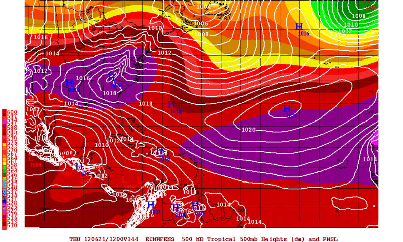
12zECMWF Ensembles keep the lower pressures confined to the BOC thru Thursday morning and beyond. 18zGFS just showed us what could happen if the center of the disturbance were to develop about 150miles NE of the 12z run, such a delicate situation!
0 likes
The following post is NOT an official forecast and should not be used as such. It is just the opinion of the poster and may or may not be backed by sound meteorological data. It is NOT endorsed by any professional institution including storm2k.org For Official Information please refer to the NHC and NWS products.
Who is online
Users browsing this forum: AnnularCane, WaveBreaking and 169 guests