NW Carribean / Southern GOM / BOC (Is invest 96L)

This is the general tropical discussion area. Anyone can take their shot at predicting a storms path.

Moderator: S2k Moderators

Forum rules

The posts in this forum are NOT official forecasts and should not be used as such. They are just the opinion of the poster and may or may not be backed by sound meteorological data. They are NOT endorsed by any professional institution or STORM2K. For official information, please refer to products from the National Hurricane Center and National Weather Service.

Help Support Storm2K
Message
Author
User avatar
vbhoutex
Storm2k Executive
Storm2k Executive
Posts: 29112
Age: 73
Joined: Wed Oct 09, 2002 11:31 pm
Location: Cypress, TX
Contact:

Re: NW Carribean / Southern GOM / BOC

#181 Postby vbhoutex » Sat Jun 16, 2012 3:49 pm

South Texas Storms wrote:The 12z CMC looks like it has a Houston landfall in about a week.
http://moe.met.fsu.edu/cgi-bin/cmctc2.c ... =Animation

As long as it stays weak like that I don't have too much problem with it. We still need the rain in SE TX, at least at my house.
0 likes   
Skywarn, C.E.R.T.
Please click below to donate to STORM2K to help with the expenses of keeping the site going:
Image

User avatar
Rgv20
S2K Supporter
S2K Supporter
Posts: 2466
Age: 38
Joined: Wed Jan 05, 2011 5:42 pm
Location: Edinburg/McAllen Tx

#182 Postby Rgv20 » Sat Jun 16, 2012 4:02 pm

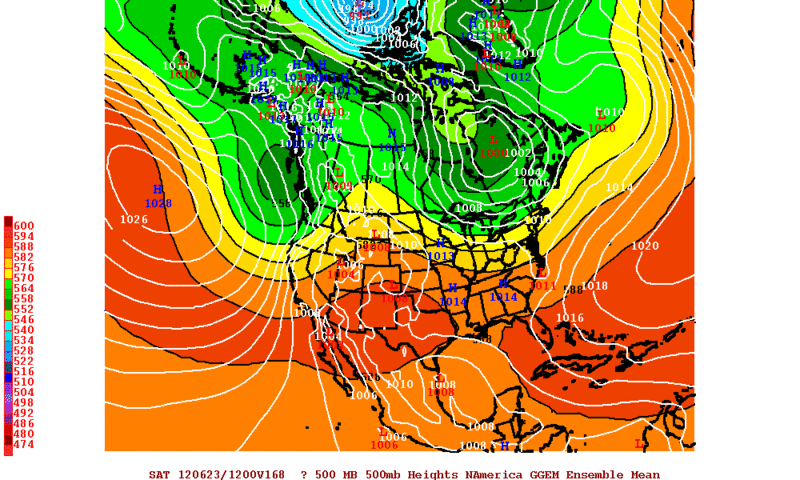
12zECMWF Ensembles Mean is in excellent agreement thru Saturday Morning with the Operational run in regards to a 1006mb Low in the BOC.

Image

I know its way too soon but what are you opinions as to/if when something gets going? My current thinking is Thursday or Friday and maybe an invest by Tuesday or Wednesday.
0 likes   
The following post is NOT an official forecast and should not be used as such. It is just the opinion of the poster and may or may not be backed by sound meteorological data. It is NOT endorsed by any professional institution including storm2k.org For Official Information please refer to the NHC and NWS products.

User avatar
tailgater
S2K Supporter
S2K Supporter
Posts: 3339
Joined: Sun Jul 11, 2004 9:13 pm
Location: St. Amant La.

Re: NW Carribean / Southern GOM / BOC

#183 Postby tailgater » Sat Jun 16, 2012 5:21 pm

Image

Is it mid June
0 likes   
The following post is NOT an official forecast and should not be used as such. It is just the opinion of the poster and may or may not be backed by sound meteorological data. It is NOT endorsed by any professional institution including storm2k.org For Official Information please refer to the NHC and NWS products.

User avatar
cycloneye
Admin
Admin
Posts: 145299
Age: 68
Joined: Thu Oct 10, 2002 10:54 am
Location: San Juan, Puerto Rico

Re: NW Carribean / Southern GOM / BOC

#184 Postby cycloneye » Sat Jun 16, 2012 5:49 pm

Here is the Afternoon discussion of possible Tropical Development in BOC by the NWS of Houston/Galveston.

LATE WEEK FORECAST FOR THE EVOLVING BAY OF CAMPECHE LOW IS STILL
ON PER ALL MODELS...WITH THE 12Z GFS AND CANADIAN RUNS BEING THE
AGGRESSORS OF TAKING THIS CLOSED-OFF LOW/CIRCULATION RIGHT UP THE
GULLY AND IMPACTING OUR AREA BY NEXT WEEKEND. NHC HAS DOWNPLAYED
THESE LATEST RUNS AS (THE GFS FOR INSTANCE) ARE SO DEVIANT FROM
THE EARLIER 06Z RUN OF TAKING THIS SYSTEM TO THE UPPER MEXICO
COAST BY NEXT WEEKEND. THE ECMWF IS MORE CONSISTENT IN KEEPING
THIS BAY OF CAMPECHE CIRCULATION MORE BROAD AND DIFFUSE. SO...A
WAIT AND SEE...BUT THIS IS DEFINITELY BECOMING A SITUATION WORTH
PAYING ATTENTION TO NEXT WEEK.
0 likes   
Visit the Caribbean-Central America Weather Thread where you can find at first post web cams,radars
and observations from Caribbean basin members Click Here

User avatar
Rgv20
S2K Supporter
S2K Supporter
Posts: 2466
Age: 38
Joined: Wed Jan 05, 2011 5:42 pm
Location: Edinburg/McAllen Tx

#185 Postby Rgv20 » Sat Jun 16, 2012 6:09 pm

18zGFS back to a more southern track.....It has a TC SE of Brownsville on Saturday Night.

Image
0 likes   
The following post is NOT an official forecast and should not be used as such. It is just the opinion of the poster and may or may not be backed by sound meteorological data. It is NOT endorsed by any professional institution including storm2k.org For Official Information please refer to the NHC and NWS products.

xcool22

#186 Postby xcool22 » Sat Jun 16, 2012 6:41 pm

18GFS dat noo good wait for 00z gfs
0 likes   

User avatar
Rgv20
S2K Supporter
S2K Supporter
Posts: 2466
Age: 38
Joined: Wed Jan 05, 2011 5:42 pm
Location: Edinburg/McAllen Tx

#187 Postby Rgv20 » Sat Jun 16, 2012 6:56 pm

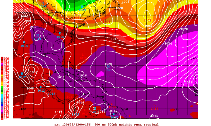
12zCMC Ensembles favor the BOC disturbance to track to the NE Mexican Coast by Saturday Morning.

Image
0 likes   
The following post is NOT an official forecast and should not be used as such. It is just the opinion of the poster and may or may not be backed by sound meteorological data. It is NOT endorsed by any professional institution including storm2k.org For Official Information please refer to the NHC and NWS products.

User avatar
Rgv20
S2K Supporter
S2K Supporter
Posts: 2466
Age: 38
Joined: Wed Jan 05, 2011 5:42 pm
Location: Edinburg/McAllen Tx

#188 Postby Rgv20 » Sun Jun 17, 2012 1:21 am

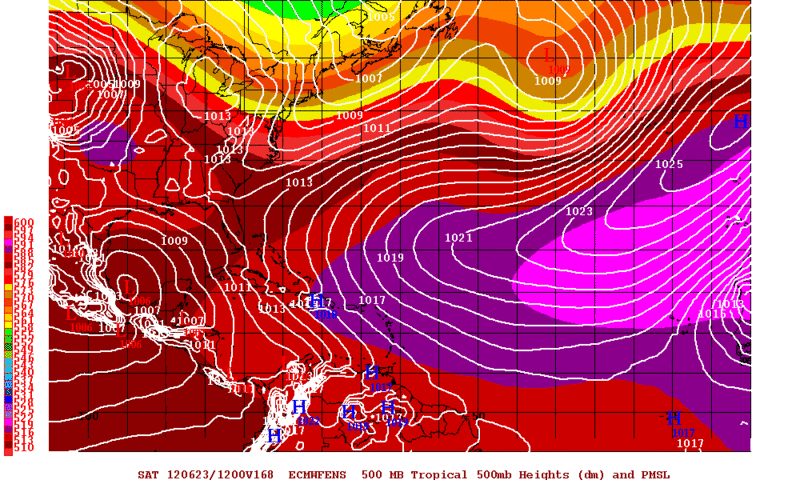
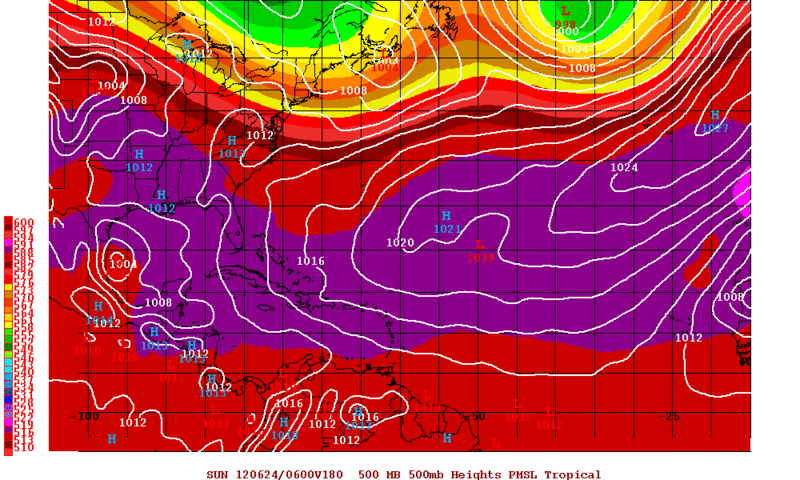
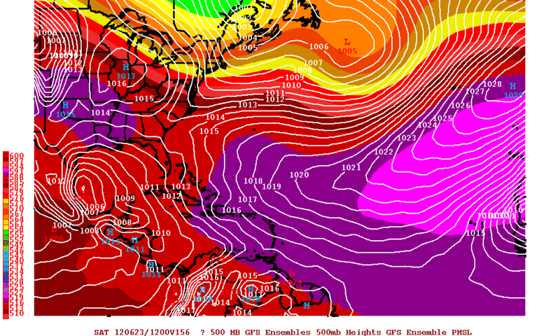
The GFS Ensemble Means have been rather consistent this past couple of days on whatever develops in the BOC to make landfall in the Central or NE Mexican Coast. The 0zGFS Ensemble Means is no different tonight and the 0z Operational GFS also has the low in the same place for Saturday Morning.

0zGFS
Image

0zGFS Ensemble Means
Image
0 likes   
The following post is NOT an official forecast and should not be used as such. It is just the opinion of the poster and may or may not be backed by sound meteorological data. It is NOT endorsed by any professional institution including storm2k.org For Official Information please refer to the NHC and NWS products.

User avatar
Hurricane Alexis
Category 2
Category 2
Posts: 683
Age: 29
Joined: Thu Jun 14, 2012 7:59 pm
Location: Miami,Florida

#189 Postby Hurricane Alexis » Sun Jun 17, 2012 1:42 am

00z NOGAPS not showing anything of notice in the BOC through 180hrs


https://www.fnmoc.navy.mil/wxmap_cgi/cg ... t=Tropical
0 likes   
Personal Forecast Disclaimer:
The posts in this forum are NOT official forecast and should not be used as such. They are just the opinion of the poster and may or may not be backed by sound meteorological data. They are NOT endorsed by any professional institution or storm2k.org. For official information, please refer to the NHC and NWS products.

User avatar
Rgv20
S2K Supporter
S2K Supporter
Posts: 2466
Age: 38
Joined: Wed Jan 05, 2011 5:42 pm
Location: Edinburg/McAllen Tx

#190 Postby Rgv20 » Sun Jun 17, 2012 1:54 am

Thru 192hrs 0zECMWF shows no TC....It did try to close off a low at 96hrs in the BOC but that was about it. Will have to take a closer look at the 0zECMWF run with Accuweather Pro in the morning.
0 likes   
The following post is NOT an official forecast and should not be used as such. It is just the opinion of the poster and may or may not be backed by sound meteorological data. It is NOT endorsed by any professional institution including storm2k.org For Official Information please refer to the NHC and NWS products.

User avatar
ROCK
Category 5
Category 5
Posts: 9484
Age: 54
Joined: Tue Aug 17, 2004 7:30 am
Location: Kemah, Texas

Re: NW Carribean / Southern GOM / BOC

#191 Postby ROCK » Sun Jun 17, 2012 3:31 am

that CMC was interesting....that would be a strong TS for sure.....but it would do wonders for the drought we are in....You see we never fully recovered from last year. Some parts of our county are in extreme drought range.....
0 likes   

User avatar
ronjon
Category 5
Category 5
Posts: 4822
Joined: Fri Aug 19, 2005 5:17 pm
Location: Hernando Beach, FL

Re: NW Carribean / Southern GOM / BOC

#192 Postby ronjon » Sun Jun 17, 2012 6:07 am

Both the 00z CMC and Euro want to produce basically two weak lows - one coming up from the western caribbean toward the SW coast of FL and other in the BOC - it then appears both models absorb the two lows into one large area of low pressure in the SW and central GOM - defintely a change from yesterdays runs. Due to the large area of the monsoon trough - which will extend from the BOC east to the Bahamas - development will be slow and the models are having a tough time latching on to anything strong - which mightjust be how this turns out. Although, nothing is moving very fast the next 10 days - a slow drift to the north - which we all know that much convection over the GOM for that long might turn into something.
0 likes   

User avatar
cycloneye
Admin
Admin
Posts: 145299
Age: 68
Joined: Thu Oct 10, 2002 10:54 am
Location: San Juan, Puerto Rico

Re: NW Carribean / Southern GOM / BOC

#193 Postby cycloneye » Sun Jun 17, 2012 6:19 am

This mornings discussions by different Texas and Louisiana NWS offices.

Brownsville:

LONG TERM /MONDAY NIGHT THROUGH SUNDAY/...THE LONG TERM TREND
REMAINS THE SAME WITH TROPICAL MOISTURE TO INCREASE ACROSS THE
WESTERN GULF AND SOUTH TEXAS. THIS WILL CONTINUE TO INCREASE OUR
CHANCES FOR RAINFALL FROM THE MIDDLE TO THE END OF NEXT WEEK.
MODELS ARE IN AGREEMENT WITH THE OVERALL TREND BUT DIFFERENCES
REMAIN IN THE DETAILS WITH ANY TYPE OF TROPICAL LOW DEVELOPMENT.
PLACEMENT AND INTENSITY VARY WITH THE EACH MODELS OUTPUT.

AS FOR THE POSSIBLE TROPICAL CYCLONE DEVELOPMENT. GFS REMAINS THE
STRONGEST DEVELOPING A WELL DEFINED CIRCULATION OVER THE SOUTHWEST
GULF. THE ECMWF IS MUCH BROADER AND WEAKER WITH THE CIRCULATION IN
THE SAME AREA AND THE CANADIAN SEEMS TO DEVELOP TWO SEPARATE LOWS
ON IN THE SOUTHWEST GULF AND THE OTHER OVER THE NORTH CENTRAL.
WONT BUY ANY OF THE SOLUTIONS UNTIL SOMETHING DEFINITE DEVELOPS.


Corpus Christi:

WEATHER FOR THE LATTER HALF OF THE WEEK AND INTO NEXT
WEEKEND REMAINS QUITE UNCERTAIN WITH LOW FORECAST CONFIDENCE. GFS
CONTINUES TO WANT TO DEVELOP A TROPICAL DEPRESSION/STORM IN THE BAY
OF CAMPECHE AND MOVE IN NNW TOWARDS THE LOWER RIO GRANDE VALLEY
/WITH PREVIOUS RUNS HAVING THE SYSTEM ANYWHERE FROM TAMPICO MX TO
LAKE CHARLES LA/. ECMWF CONTINUES TO HAVE THE BEST RUN TO RUN
CONSISTENCY AND KEEPS BROAD LOW PRESSURE ACROSS THE SW GULF WITH
DEEP TROPICAL MOISTURE MOVING INTO S TX LATE THIS WEEK AND NEXT
WEEKEND. 00Z ECMWF HAS SHIFTED A LITTLE FARTHER SOUTH WITH DEEPER
MOISTURE AND THUS IS A LITTLE DRIER THAN PREVIOUS RUNS.

Houston/Galveston:

BY MIDWEEK EYES BEGIN LOOKING SOUTH TO BAY OF CAMPECHE WHERE SOME
SORT OF TROPICAL FEATURE LOOKING MORE CERTAIN TO DEVELOP. GFS HAS
HAD LESS RUN TO RUN CONSISTENCY WITH THIS DEVELOPMENT SO OUR
FORECAST WILL WEIGH ECMWF SOLUTIONS MORE HEAVILY IN FINAL
PRODUCTS. ECMWF HAS MORE OF A BROAD CYCLONIC CIRCULATION
DIRECTLY UNDERNEATH THE UPPER HIGH WHILE GFS ENDS UP WITH THE
UPPER HIGH FURTHER NORTH OF THE DEVELOPING SFC FEATURES. STILL
WARM AND HUMID AND IT LOOKS LIKE A GOOD WEEK FOR RAIN CHANCES.

Austin/San Antonio:

THE GFS CONTINUES TO DEVELOP A CLOSED TROPICAL
SYSTEM IN THE SWRN/WRN GULF LATE IN THE WEEK INTO NEXT WEEKEND...WHILE
THE ECMWF CONTINUES TO SHOW A MORE BROAD LOW OVER THE SRN GULF...WITH
EASTERLY MID LEVEL FLOW INTO S TX.

Lake Charles,Louisiana:

SECOND FEATURE OF INTEREST IS POSSIBLE TROPICAL DEVELOPMENT IN THE
SWRN GULF LATE IN THE PERIOD. ALL THE MODELS ARE PINGING ON SOME
SORT OF LOW DEVELOPMENT IN THE BAY OF CAMPECHE BY MID-WEEK...
UNFORTUNATELY THEIR SOLUTIONS DIFFER GREATLY AT THIS POINT. GFS
REMAINS MOST BULLISH WITH THIS SYSTEM...DEEPENING IT AND CARRYING
IT INTO THE NRN MEXICAN COAST BY NEXT WEEKEND. EUROPEAN BASICALLY
SITS AND SPINS IT IN THE SWRN GULF WHILE THE CANADIAN WHIPS IT OFF
TO THE NE TOWARD THE CNTL/ERN GULF COAST. FOR NOW WILL FOLLOW THE
GFS LEAD WITH ITS MOSTLY CONSISTENT SOLUTION ALTHOUGH WILL TONE
WINDS/POPS DOWN A LITTLE TO ACCOUNT FOR LACK OF GOOD CONFIDENCE.

New Orleans/Baton Rouge:

RAIN CHANCES MAY INCH
UP A BIT TOWARD THE END OF THE WORK WEEK AND INTO NEXT WEEKEND IF
AN AREA OF LOW PRESSURE DEVELOPS OR MOVES INTO THE SOUTHWEST GULF
WITH A WAVE MOVING ACROSS THE CENTRAL GULF BRINGING INCREASED
MOISTURE NORTHWARD AS THE MODELS HAVE INDICATED FOR SEVERAL RUNS
NOW. HOWEVER...THE LATEST TREND WITH THE MEDIUM RANGE MODEL RUNS
HAS BEEN TOWARD A DRIER SOLUTION FOR THE CENTRAL GULF COAST REGION
FOR THE END OF THE WEEK WITH RIDGING REMAINING IN CONTROL AND THE
BEST MOISTURE REMAINING TO THE SOUTH AND WEST OF THE REGION.
0 likes   
Visit the Caribbean-Central America Weather Thread where you can find at first post web cams,radars
and observations from Caribbean basin members Click Here

User avatar
wxman57
Moderator-Pro Met
Moderator-Pro Met
Posts: 22978
Age: 67
Joined: Sat Jun 21, 2003 8:06 pm
Location: Houston, TX (southwest)

Re:

#194 Postby wxman57 » Sun Jun 17, 2012 7:08 am

Rgv20 wrote:The GFS Ensemble Means have been rather consistent this past couple of days on whatever develops in the BOC to make landfall in the Central or NE Mexican Coast. The 0zGFS Ensemble Means is no different tonight and the 0z Operational GFS also has the low in the same place for Saturday Morning.

0zGFS
http://i61.photobucket.com/albums/h62/c ... cal156.gif

0zGFS Ensemble Means
http://i61.photobucket.com/albums/h62/c ... cal156.gif


00Z Euro ensembles have an 80% chance of tropical cyclone development in the southwest Gulf late this week. They were up to 90% yesterday.
0 likes   

User avatar
perk
Category 3
Category 3
Posts: 825
Joined: Mon Aug 09, 2004 9:35 am
Location: Richmond Texas

Re: NW Carribean / Southern GOM / BOC

#195 Postby perk » Sun Jun 17, 2012 7:52 am

wxman57 any thoughts you can share on this anticipated system.
0 likes   

User avatar
NDG
S2K Supporter
S2K Supporter
Posts: 15446
Joined: Sun Jul 09, 2006 10:14 pm
Location: Orlando, FL

Re: NW Carribean / Southern GOM / BOC

#196 Postby NDG » Sun Jun 17, 2012 8:07 am

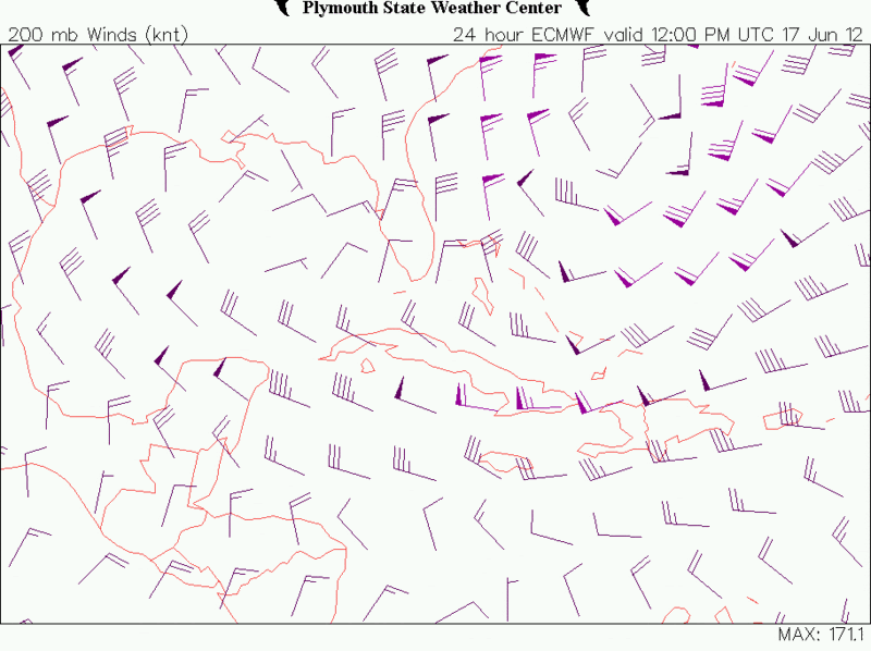
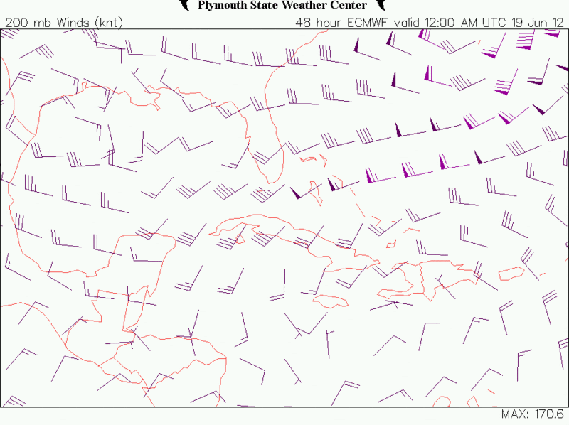
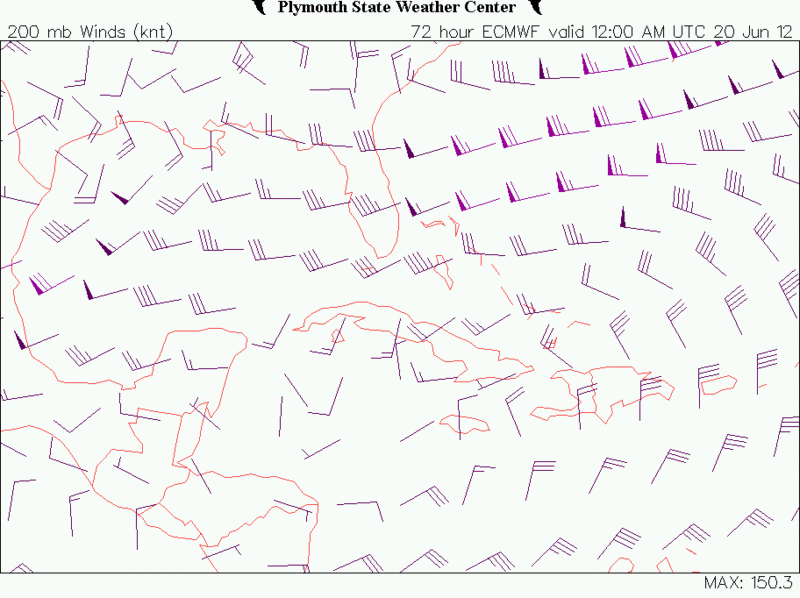
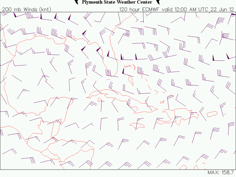
Shear is ripping across the Caribbean & southern GOM this morning, as forecasted by models a few days ago, it was eminent as the inverted trough, TUTT like, in the western Atlantic has dug southwestward during the weekend.
That trough is forecasted to lift up into the northern Atlantic as mid level ridging builds across the subtropical Atlantic and moves westward setting up for better upper level conditions to start setting up across the Caribbean as early as tomorrow night and to continue moving on NW towards the southern GOM fairly much on top of the tropical disturbance.
With such UL environment, I give it good chance for tropical development to start going if not in the NW Caribbean in a couple of days, definitely in the southern GOM afterwards.

Current H20 winds:
Image

Tomorrow evening's H20 winds, improving conditions.
Image

Tuesday, UL ridge centered over the NW Caribbean, continuing to build westward.
Image

Thursday, the UL ridge centered of the SW GOM, setting up for great upper level conditions.
Image

The posts in this forum are NOT official forecast and should not be used as such. They are just the opinion of the poster and may or may not be backed by sound meteorological data. They are NOT endorsed by any professional institution or storm2k.org. For official information, please refer to the NHC and NWS products.
0 likes   

Aric Dunn
Category 5
Category 5
Posts: 21238
Age: 42
Joined: Sun Sep 19, 2004 9:58 pm
Location: Ready for the Chase.
Contact:

#197 Postby Aric Dunn » Sun Jun 17, 2012 8:34 am

keep watching thed s w Caribbean wellw e s t e r n n o w
0 likes   
Note: If I make a post that is brief. Please refer back to previous posts for the analysis or reasoning. I do not re-write/qoute what my initial post said each time.
If there is nothing before... then just ask :)

Space & Atmospheric Physicist, Embry-Riddle Aeronautical University,
I believe the sky is falling...

User avatar
wxman57
Moderator-Pro Met
Moderator-Pro Met
Posts: 22978
Age: 67
Joined: Sat Jun 21, 2003 8:06 pm
Location: Houston, TX (southwest)

Re: NW Carribean / Southern GOM / BOC

#198 Postby wxman57 » Sun Jun 17, 2012 8:35 am

perk wrote:wxman57 any thoughts you can share on this anticipated system.


Perhaps a 70% chance of a TD/TS in western Gulf by Thursday afternoon. Heading slowly north to northern MX or Texas. Depending on upper-level winds, it could be a hurricane at landfall. I wonder what the 5-day tropical outlooks issued internally by the NHC this year are saying. Is it even possible that their forecast scheme could say a greater than 50% chance of development 4 days out?

Just checking those Euro ensembles again. Hadn't looked at the day 1-3 range when I made my last post. It has a 90% chance of TC development in the NW Caribbean within 72 hrs, shifting to a 70-80% chance of development in the SW Gulf beyond 84 hrs.
0 likes   

User avatar
perk
Category 3
Category 3
Posts: 825
Joined: Mon Aug 09, 2004 9:35 am
Location: Richmond Texas

Re: NW Carribean / Southern GOM / BOC

#199 Postby perk » Sun Jun 17, 2012 8:47 am

wxman57 wrote:
perk wrote:wxman57 any thoughts you can share on this anticipated system.


Perhaps a 70% chance of a TD/TS in western Gulf by Thursday afternoon. Heading slowly north to northern MX or Texas. Depending on upper-level winds, it could be a hurricane at landfall. I wonder what the 5-day tropical outlooks issued internally by the NHC this year are saying. Is it even possible that their forecast scheme could say a greater than 50% chance of development 4 days out?


wxman57 thanks for your thoughts on this upcoming week,as always they are appreciated.
0 likes   

User avatar
cycloneye
Admin
Admin
Posts: 145299
Age: 68
Joined: Thu Oct 10, 2002 10:54 am
Location: San Juan, Puerto Rico

Re: NW Carribean / Southern GOM / BOC

#200 Postby cycloneye » Sun Jun 17, 2012 8:50 am

This mornings discussion of what may occur this week in the BOC by Rob of Crown Weather.

The following post is NOT an official forecast and should not be used as such. It is just the opinion of the poster and may or may not be backed by sound meteorological data. It is NOT endorsed by any professional institution including storm2k.org. For Official Information please refer to the NHC and NWS products.

http://www.crownweather.com/?page_id=4557


We Will Be Closely Watching The Western Gulf Of Mexico For Possible Tropical Development Later This Week Into Next Weekend

Sunday, June 17, 2012 9:10 am

by Rob Lightbown


I wanted to update all of you on the chances for tropical development in the western Gulf of Mexico & Bay of Campeche later this week. As I have mentioned, the model guidance has been strongly hinting at the potential for tropical development in the Bay of Campeche during the Wednesday through Thursday timeframe.

Analysis this morning showed a monsoonal low pressure system over the southwestern Caribbean. This low pressure system is producing widespread shower and thunderstorm activity across much of the central & western Caribbean. The large complex of thunderstorms just southeast of Jamaica is likely being created by divergence from the low pressure system located to the south-southwest of Bermuda.

The forecast guidance generally are in agreement that a broad area of low pressure will develop during the Wednesday timeframe near Vera Cruz in the western part of the Bay of Campeche and then slowly track northward just offshore of Mexico’s east coast towards northeastern Mexico and south Texas by very late this week and into this weekend.

The GFS model does tighten up this storm enough to likely be classified as a tropical storm as it comes ashore just south of Brownsville next Sunday. The European model forecasts a very broad area of low pressure that sits over the central and western Gulf of Mexico from Friday to at least next Tuesday. The Canadian model is the extreme of all of the guidance and I am going to disregard it for now. The Canadian forecasts the development of a tropical cyclone in the southeastern Gulf of Mexico by Wednesday and forecasts it to track west-northwest and intensify through the rest of the week and into next weekend and forecasts it to be sitting just southeast of New Orleans by next Sunday morning. Again, I am not buying into this solution at this time as there is no evidence to support its forecast.

So, here is my thinking:
That large area of moisture that is now building in the western Caribbean will slowly push northward this week and the overall upper level pattern over North America and the western Atlantic favors the piling up of moisture and heat in the western Gulf of Mexico and I strongly believe that this will lead to first the development of a tropical disturbance in the Bay of Campeche between Wednesday and Thursday and then this disturbance strengthening into a tropical depression or a tropical storm in the Bay of Campeche or western Gulf of Mexico sometime next weekend.

Heavy Rain Potential: It should be noted that very heavy rain is likely along the Texas and Louisiana coastline between Wednesday and Sunday which will likely lead to flood issues.
0 likes   
Visit the Caribbean-Central America Weather Thread where you can find at first post web cams,radars
and observations from Caribbean basin members Click Here


Return to “Talkin' Tropics”

Who is online

Users browsing this forum: No registered users and 22 guests