NW Carribean / Southern GOM / BOC (Is invest 96L)

This is the general tropical discussion area. Anyone can take their shot at predicting a storms path.

Moderator: S2k Moderators

Forum rules

The posts in this forum are NOT official forecasts and should not be used as such. They are just the opinion of the poster and may or may not be backed by sound meteorological data. They are NOT endorsed by any professional institution or STORM2K. For official information, please refer to products from the National Hurricane Center and National Weather Service.

Help Support Storm2K
Message
Author
User avatar
Rgv20
S2K Supporter
S2K Supporter
Posts: 2466
Age: 38
Joined: Wed Jan 05, 2011 5:42 pm
Location: Edinburg/McAllen Tx

#221 Postby Rgv20 » Sun Jun 17, 2012 12:11 pm

Thru 120hrs the GFS Ensemble Means have not wavered on the idea of something developing in the BOC....Pretty impressive consistency and is only 4 to 5 days out.

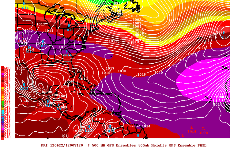
12zGFS Ensemble Means forecast valid for Friday Morning.
Image
0 likes   
The following post is NOT an official forecast and should not be used as such. It is just the opinion of the poster and may or may not be backed by sound meteorological data. It is NOT endorsed by any professional institution including storm2k.org For Official Information please refer to the NHC and NWS products.

djmikey
Tropical Storm
Tropical Storm
Posts: 153
Joined: Tue Jul 20, 2010 6:04 pm
Location: Beaumont, TX

Re: NW Carribean / Southern GOM / BOC

#222 Postby djmikey » Sun Jun 17, 2012 12:23 pm

I stick to my post a several pages back...."Watch this end up being a Mexico storm....AGAIN!"
0 likes   

Aric Dunn
Category 5
Category 5
Posts: 21238
Age: 42
Joined: Sun Sep 19, 2004 9:58 pm
Location: Ready for the Chase.
Contact:

#223 Postby Aric Dunn » Sun Jun 17, 2012 12:31 pm

0 likes   
Note: If I make a post that is brief. Please refer back to previous posts for the analysis or reasoning. I do not re-write/qoute what my initial post said each time.
If there is nothing before... then just ask :)

Space & Atmospheric Physicist, Embry-Riddle Aeronautical University,
I believe the sky is falling...

Aric Dunn
Category 5
Category 5
Posts: 21238
Age: 42
Joined: Sun Sep 19, 2004 9:58 pm
Location: Ready for the Chase.
Contact:

#224 Postby Aric Dunn » Sun Jun 17, 2012 12:35 pm

0 likes   
Note: If I make a post that is brief. Please refer back to previous posts for the analysis or reasoning. I do not re-write/qoute what my initial post said each time.
If there is nothing before... then just ask :)

Space & Atmospheric Physicist, Embry-Riddle Aeronautical University,
I believe the sky is falling...

User avatar
ronjon
Category 5
Category 5
Posts: 4822
Joined: Fri Aug 19, 2005 5:17 pm
Location: Hernando Beach, FL

Re: NW Carribean / Southern GOM / BOC

#225 Postby ronjon » Sun Jun 17, 2012 2:09 pm

I'm sensing a shift in the models with the western caribbean perhaps becoming the focal point for low pressure development. Interesting that 12Z GFS is now coming around to 00z Euro and CMC runs this morning - it now places a weak 1009 mb low over S FL by Wed-Thur timeframe. Throw NOGAPS and NAM in there as well for what its worth. We might need to watch the Yucatan channel, FL straits, or SE GOM for possible development in 3-5 days.
0 likes   

Aric Dunn
Category 5
Category 5
Posts: 21238
Age: 42
Joined: Sun Sep 19, 2004 9:58 pm
Location: Ready for the Chase.
Contact:

#226 Postby Aric Dunn » Sun Jun 17, 2012 2:33 pm

convection starting to develop with circ near honduras. keep close eye on it
0 likes   
Note: If I make a post that is brief. Please refer back to previous posts for the analysis or reasoning. I do not re-write/qoute what my initial post said each time.
If there is nothing before... then just ask :)

Space & Atmospheric Physicist, Embry-Riddle Aeronautical University,
I believe the sky is falling...

bilhhh
Tropical Low
Tropical Low
Posts: 10
Joined: Sat Aug 21, 2010 5:07 am

#227 Postby bilhhh » Sun Jun 17, 2012 3:03 pm

Any areas reached the status of an "invest" yet?
Have forgotten which NHC page shows Invests.
Thank you,
Bil
PS pls excuse if I am slow to reply as I am super busy today! Bless all of you.
PS wd like to hear your favorite schemes for preventing/steering storms. Any like the sulfur particle/reflection via low atmosphere rocket idea?
0 likes   

User avatar
Rgv20
S2K Supporter
S2K Supporter
Posts: 2466
Age: 38
Joined: Wed Jan 05, 2011 5:42 pm
Location: Edinburg/McAllen Tx

#228 Postby Rgv20 » Sun Jun 17, 2012 3:07 pm

Brownsville Afternoon discussion.

"MID- AND UPPER-LEVEL RIDGING IS FORECAST TO BUILD ACROSS THE
CENTRAL PART OF THE COUNTRY FOR THE LATTER PART OF THE WEEK AS THE
INVERTED UPPER TROUGH HEADS WEST. THIS SHOULD RESULT IN CONTINUED
ABOVE NORMAL CONVECTIVE PROBABILITIES...AS TROPICAL EASTERLIES ARE
ALLOWED TO RETURN TO OUR AREA. UNFORTUNATELY...MY CONFIDENCE IN THE
FORECAST ALSO STARTS TO WANE DURING THIS TIME GIVEN THE MULTIPLE
SOLUTIONS PROVIDED BY THE MODELS DURING THE DAY 5 THROUGH 7 TIME
PERIOD.

COMPUTER MODELS HAVE BEEN CONSISTENT /OVER THE PAST COUPLE OF DAYS/
IN DEVELOPING A CLOSED LOW IN THE BAY OF CAMPECHE/SOUTHWEST GULF OF
MEXICO THURSDAY OR FRIDAY...FROM A SOUTHWEST TO NORTHEAST ORIENTED
TROUGH OF LOW PRESSURE IN THE GULF. THE MODELS DEVELOP THIS SYSTEM
TO VARYING DEGREES...WITH THE GFS STILL SHOWING THE GREATEST
DEVELOPMENT OF THIS SYSTEM. IT LOOKS LIKE THIS SYSTEM SHOULD SHOW A
GENERAL WEST-NORTHWEST MOVEMENT HEADING INTO THE WEEKEND /AT LEAST
AS OF RIGHT NOW/.

REGARDLESS OF ITS STRENGTH/DEVELOPMENT...IF WE ASSUME THE GENERAL
FORECAST MOVEMENT IS CORRECT....ADDITIONAL DEEP LOW-LEVEL MOISTURE
COULD HEAD INTO OUR AREA FOR NEXT WEEKEND. THIS MAY RESULT IN AN
INCREASE IN SHOWER/THUNDERSTORM PROBABILITIES WITH LATER FORECASTS.
FOR NOW THOUGH...I PLAN ON TAKING THE COURSE OF LEAST REGRET AND
STAYING PRETTY CLOSE TO THE ONGOING FORECAST DURING THIS TIME
BECAUSE OF ALL THE UNCERTAINTIES."
0 likes   
The following post is NOT an official forecast and should not be used as such. It is just the opinion of the poster and may or may not be backed by sound meteorological data. It is NOT endorsed by any professional institution including storm2k.org For Official Information please refer to the NHC and NWS products.

User avatar
cycloneye
Admin
Admin
Posts: 145301
Age: 68
Joined: Thu Oct 10, 2002 10:54 am
Location: San Juan, Puerto Rico

Re:

#229 Postby cycloneye » Sun Jun 17, 2012 3:09 pm

bilhhh wrote:Any areas reached the status of an "invest" yet?
Have forgotten which NHC page shows Invests.
Thank you,
Bil
PS pls excuse if I am slow to reply as I am super busy today! Bless all of you.
PS wd like to hear your favorite schemes for preventing/steering storms. Any like the sulfur particle/reflection via low atmosphere rocket idea?


You can follow this site where the invests are activated and updated.

http://ftp.nhc.noaa.gov/atcf/tcweb/
0 likes   
Visit the Caribbean-Central America Weather Thread where you can find at first post web cams,radars
and observations from Caribbean basin members Click Here

RL3AO
Moderator-Pro Met
Moderator-Pro Met
Posts: 16308
Joined: Thu Jun 14, 2007 10:03 pm
Location: NC

Re:

#230 Postby RL3AO » Sun Jun 17, 2012 3:09 pm

bilhhh wrote:Any areas reached the status of an "invest" yet?
Have forgotten which NHC page shows Invests.
Thank you,


http://ftp.nhc.noaa.gov/atcf/tcweb/?C=M;O=D

PS wd like to hear your favorite schemes for preventing/steering storms. Any like the sulfur particle/reflection via low atmosphere rocket idea?


Storms are way too big and steered by forces way too large for any human intervention to make a dent in controller where they go.
0 likes   

User avatar
cycloneye
Admin
Admin
Posts: 145301
Age: 68
Joined: Thu Oct 10, 2002 10:54 am
Location: San Juan, Puerto Rico

Re: NW Carribean / Southern GOM / BOC

#231 Postby cycloneye » Sun Jun 17, 2012 3:24 pm

From the afternoon discussion by NWS Corpus Christi:

.LONG TERM (TUESDAY THROUGH SUNDAY)...MODELS HAVE BACKED OFF ON
DVLPG A TROPICAL SYSTEM IN THE BAY OF CAMPECHE AND ARE ALL MORE IN
LINE WITH THE ECMWF WITH DVLPG JUST A BROAD AREA OF LOW PRESSURE.

MODELS CONT TO BRING DEEPER GULF MOISTURE INTO S TX WITH PRECIP
COMING IN WAVES ON THE NRN PERIPHERY OF THE BROAD LOW. LATEST MODELS
SOLNS SHOW WED NOW BEING THE WETTER DAY AS AN UPPER TROF AXIS MOVES
TO THE WEST OF THE AREA...AND DECREASING CHCS THU AND ESPECIALLY FRI
AS THE UPPER TROF CONTS TO TRACK FARTHER WEST LEAVING S TX IN A MORE
SUBSIDENT AIRMASS. AS FOR POPS...ONLY MADE TWEAKS TO TUE POPS AS
THEY STILL LOOK REASONABLE AHD OF THE UPPER TROF. HAVE INCREASED WED
POPS GIVEN LATEST MODEL TRENDS MOVG THE UPPER TROF ACROSS THE
AREA...BUT DID NOT GO AS HIGH AS GUIDANCE. DID NOT MAKE ANY
SIGNIFICANT CHANGES TO THU KEEPING THE 20-40 POPS. DECREASED FRI
POPS...BUT DID NOT GO AS LOW AS GUIDANCE DUE TO THE UNCERTAINTY.
MADE NO MAJOR CHANGES TO NEXT WEEKEND AS MODELS PROG ANOTHER WAVE
APPROACHES THE AREA. ONLY MADE TWEAKS TO THE TEMPS AND WIND FCSTS
BUT OVERALL THEY LOOKED GOOD.
0 likes   
Visit the Caribbean-Central America Weather Thread where you can find at first post web cams,radars
and observations from Caribbean basin members Click Here

bilhhh
Tropical Low
Tropical Low
Posts: 10
Joined: Sat Aug 21, 2010 5:07 am

Re: NW Carribean / Southern GOM / BOC

#232 Postby bilhhh » Sun Jun 17, 2012 3:30 pm

Hello Eye, RL,
Thanks for the links!
They will be most helpful soon, I believe. Appreciate your taking the time to look up the links. We layfolks are highly dependent on you weather experts for keeping us safe from the storms. You are like cell walls keeping bacteria out of the cytoplasm.
-------------------
As to the sulfur,.
True, storms are pretty large.
Last edited by bilhhh on Sun Jun 17, 2012 3:49 pm, edited 1 time in total.
0 likes   

User avatar
cycloneye
Admin
Admin
Posts: 145301
Age: 68
Joined: Thu Oct 10, 2002 10:54 am
Location: San Juan, Puerto Rico

Re: NW Carribean / Southern GOM / BOC

#233 Postby cycloneye » Sun Jun 17, 2012 3:47 pm

Afternoon discussion by NWS Houston/Galveston:

THE RUN-TO-RUN CONSISTENCY OF THE ECMWF HAS THE EXTENDED LEANING
TOWARDS THIS SOLUTION CONCERNING THE LATE WEEK EVOLUTION OF THE
BAY OF CAMPECHE CIRCULATION. THAT BEING OF A VERY BROAD...DIFFUSE
LOW SLOWLY MEANDERING MORE WEST THAN NORTH THROUGH DAY 7. THE GFS
AND CANADIAN ARE NOT AS AGGRESSIVE AS IN PREVIOUS RUNS...TRENDING
MORE TOWARDS THE EURO`S MESSAGE
. MONSTROUS RIDGING ENVELOPES THE
U.S. PLAINS NEXT WEEKEND THAT WILL NOT ONLY SHUNT/SUPPRESS ANY
TROPICAL ACTIVITY FURTHER SOUTH BUT ALSO SHUT DOWN ANY PRECIPITATION.
AFTER AN ON-AND-OFF AGAIN SHOWERY START TO THE WEEK...IT MAY VERY
WELL END HOT AND DRY (PRECIP-WISE).
0 likes   
Visit the Caribbean-Central America Weather Thread where you can find at first post web cams,radars
and observations from Caribbean basin members Click Here

floridasun78
Category 5
Category 5
Posts: 3755
Joined: Sun May 17, 2009 10:16 pm
Location: miami fl

Re: NW Carribean / Southern GOM / BOC

#234 Postby floridasun78 » Sun Jun 17, 2012 4:04 pm

so now back looking at nw carribbean again?
0 likes   

User avatar
NDG
S2K Supporter
S2K Supporter
Posts: 15446
Joined: Sun Jul 09, 2006 10:14 pm
Location: Orlando, FL

Re: NW Carribean / Southern GOM / BOC

#235 Postby NDG » Sun Jun 17, 2012 4:05 pm

Long live king Euro.
0 likes   

User avatar
Rgv20
S2K Supporter
S2K Supporter
Posts: 2466
Age: 38
Joined: Wed Jan 05, 2011 5:42 pm
Location: Edinburg/McAllen Tx

#236 Postby Rgv20 » Sun Jun 17, 2012 4:06 pm

12zECMWF Ensemble Means do support an idea of a Tropical Low in the BOC/Western Gulf Coast......Below is the 144 & 168hrs forecast and it has the low crawling to the NW. Models still support some kind of development in the BOC but the details are sketchy. FWIW the 12zJMA (Japanese Model) does develop a low and moves it toward the NE Mexican Coast by this coming weekend.

Image

Image
0 likes   
The following post is NOT an official forecast and should not be used as such. It is just the opinion of the poster and may or may not be backed by sound meteorological data. It is NOT endorsed by any professional institution including storm2k.org For Official Information please refer to the NHC and NWS products.

User avatar
NDG
S2K Supporter
S2K Supporter
Posts: 15446
Joined: Sun Jul 09, 2006 10:14 pm
Location: Orlando, FL

#237 Postby NDG » Sun Jun 17, 2012 4:22 pm

From past experiences Eur's ensembles don't do too well in the GOM.
0 likes   

Aric Dunn
Category 5
Category 5
Posts: 21238
Age: 42
Joined: Sun Sep 19, 2004 9:58 pm
Location: Ready for the Chase.
Contact:

Re: NW Carribean / Southern GOM / BOC

#238 Postby Aric Dunn » Sun Jun 17, 2012 5:59 pm

floridasun78 wrote:so now back looking at nw carribbean again?

should never have stopped. al model from the beginning alwzys had at least energy coming from the csrrib. esrlier runs had nothing but a csrrib system
0 likes   
Note: If I make a post that is brief. Please refer back to previous posts for the analysis or reasoning. I do not re-write/qoute what my initial post said each time.
If there is nothing before... then just ask :)

Space & Atmospheric Physicist, Embry-Riddle Aeronautical University,
I believe the sky is falling...

User avatar
Ivanhater
Storm2k Moderator
Storm2k Moderator
Posts: 11161
Age: 38
Joined: Fri Jul 01, 2005 8:25 am
Location: Pensacola

Re: NW Carribean / Southern GOM / BOC

#239 Postby Ivanhater » Sun Jun 17, 2012 6:19 pm

Sure is soupy in the Caribbean

Image
0 likes   
Michael

User avatar
Rgv20
S2K Supporter
S2K Supporter
Posts: 2466
Age: 38
Joined: Wed Jan 05, 2011 5:42 pm
Location: Edinburg/McAllen Tx

#240 Postby Rgv20 » Sun Jun 17, 2012 6:22 pm

It seems that the models today want to split the energy between the BOC and around the florida keys area......I do not expect the area over south florida to develop much but its going to rob some energy of the potential BOC system. IMO that is why the GFS has been trending weaker and weaker with it.

18zGFS Ensemble Means
Image
0 likes   
The following post is NOT an official forecast and should not be used as such. It is just the opinion of the poster and may or may not be backed by sound meteorological data. It is NOT endorsed by any professional institution including storm2k.org For Official Information please refer to the NHC and NWS products.


Return to “Talkin' Tropics”

Who is online

Users browsing this forum: Google Adsense [Bot], SconnieCane and 27 guests