

Why, oh why? Would you say the weather is going to mess up weekend plans around the gulf coast? Beach plans, a bad thing at this point?
arrgh
NW Carribean / Southern GOM / BOC (Is invest 96L)
Moderator: S2k Moderators
Forum rules

The posts in this forum are NOT official forecasts and should not be used as such. They are just the opinion of the poster and may or may not be backed by sound meteorological data. They are NOT endorsed by any professional institution or STORM2K. For official information, please refer to products from the National Hurricane Center and National Weather Service.
-
floridasun78
- Category 5

- Posts: 3755
- Joined: Sun May 17, 2009 10:16 pm
- Location: miami fl
Re: NW Carribean / Southern GOM / BOC
it kill my beach plan here in miami start of my vacation
0 likes

Re:
bayoubebe wrote:Why, oh why? Would you say the weather is going to mess up weekend plans around the gulf coast? Beach plans, a bad thing at this point?
arrgh
Let's hope the Nam is wrong again.
0 likes
The following post is NOT an official forecast and should not be used as such. It is just the opinion of the poster and may or may not be backed by sound meteorological data. It is NOT endorsed by any professional institution including storm2k.org For Official Information please refer to the NHC and NWS products.
Re:
bayoubebe wrote:Why, oh why? Would you say the weather is going to mess up weekend plans around the gulf coast? Beach plans, a bad thing at this point?
arrgh
the panhandle may be fine for the weekend with a better chance of wetter weather over peninsular florida. stay tuned
0 likes
-
Rgv20

- S2K Supporter

- Posts: 2466
- Age: 39
- Joined: Wed Jan 05, 2011 5:42 pm
- Location: Edinburg/McAllen Tx
0zGFS Ensemble Means has a 1005mb Low just north of the Yucatan Peninsula (0zGFS has it NE of the Yucatan) by Saturday Morning.
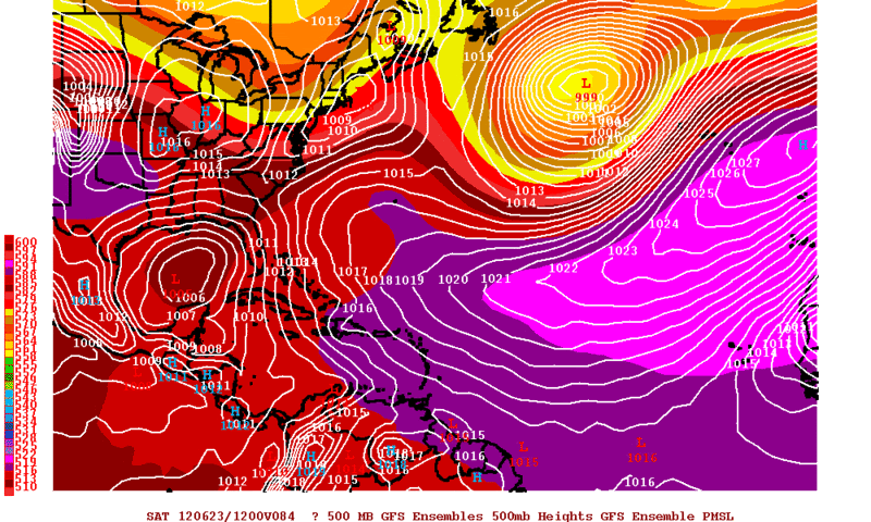
By Sunday Morning the Ensembles begin to diverge greatly....A sure sign that the GFS is still having a difficult time handling this disturbance.
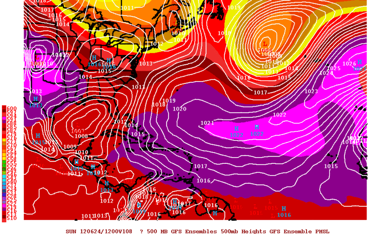
By Sunday Morning the Ensembles begin to diverge greatly....A sure sign that the GFS is still having a difficult time handling this disturbance.
0 likes
The following post is NOT an official forecast and should not be used as such. It is just the opinion of the poster and may or may not be backed by sound meteorological data. It is NOT endorsed by any professional institution including storm2k.org For Official Information please refer to the NHC and NWS products.

-
cycloneye

- Admin

- Posts: 149283
- Age: 69
- Joined: Thu Oct 10, 2002 10:54 am
- Location: San Juan, Puerto Rico
Re: NW Carribean / Southern GOM / BOC
Stays at 10%.
A LOW PRESSURE TROUGH EXTENDING FROM THE NORTHWESTERN CARIBBEAN SEA
NORTHEASTWARD TO THE BAHAMAS IS PRODUCING WIDESPREAD CLOUDINESS...
SHOWERS...AND THUNDERSTORMS. UPPER-LEVEL WINDS ARE NOT
PARTICULARLY CONDUCIVE FOR DEVELOPMENT...AND THIS SYSTEM HAS A LOW
CHANCE...10 PERCENT...OF BECOMING A TROPICAL CYCLONE DURING THE
NEXT 48 HOURS. HEAVY RAINFALL IS LIKELY ACROSS THE CAYMAN
ISLANDS...CUBA...THE BAHAMAS...AND SOUTHERN FLORIDA OVER THE NEXT
COUPLE OF DAYS AS THE SYSTEM MOVES NORTHWESTWARD AT 5 TO 10 MPH.
FLOODING IS ALSO POSSIBLE IN THESE AREAS...ESPECIALLY IN CUBA WHERE
THE GROUND IS ALREADY SATURATED FROM HEAVY RAINFALL OVER THE PAST
SEVERAL WEEKS.
0 likes
Visit the Caribbean-Central America Weather Thread where you can find at first post web cams,radars
and observations from Caribbean basin members Click Here
and observations from Caribbean basin members Click Here
-
Ivanhater

- Storm2k Moderator

- Posts: 11221
- Age: 39
- Joined: Fri Jul 01, 2005 8:25 am
- Location: Pensacola
Re: NW Carribean / Southern GOM / BOC
00z Euro coming in much stronger with the Gulf low

0 likes
Michael

-
Hurricane Alexis

- Category 2

- Posts: 683
- Age: 29
- Joined: Thu Jun 14, 2012 7:59 pm
- Location: Miami,Florida
Re: NW Carribean / Southern GOM / BOC
[img]
Uploaded with ImageShack.us[/img]
Is that shear affecting the disturbanc or good outflow being released from it?

Uploaded with ImageShack.us[/img]
Is that shear affecting the disturbanc or good outflow being released from it?
0 likes
Personal Forecast Disclaimer:
The posts in this forum are NOT official forecast and should not be used as such. They are just the opinion of the poster and may or may not be backed by sound meteorological data. They are NOT endorsed by any professional institution or storm2k.org. For official information, please refer to the NHC and NWS products.
The posts in this forum are NOT official forecast and should not be used as such. They are just the opinion of the poster and may or may not be backed by sound meteorological data. They are NOT endorsed by any professional institution or storm2k.org. For official information, please refer to the NHC and NWS products.
-
northjaxpro

- S2K Supporter
- Posts: 8900
- Joined: Mon Sep 27, 2010 11:21 am
- Location: Jacksonville, FL
Looks pretty good early this morning. Satellite shows convective burst has maintained overnight. Also, there are some very deep convective tops as well, signaling good low level convergence near the Isle of Youth. Still shear for sure affecting the region, but it definitely appears that we may be seeing our Low Pressure area finally beginning to take shape. If the trend continues with the convection, I think we probably will see this area get tagged as an invest later today by NHC.
The posts in this forum are NOT official forecast and should not be used as such. They are just the opinion of this poster and may or may not be backed by sound meteorological data. They are NOT endorsed by any professional institution or storm2k.org. For official information, please refer to the NHC and NWS products.
The posts in this forum are NOT official forecast and should not be used as such. They are just the opinion of this poster and may or may not be backed by sound meteorological data. They are NOT endorsed by any professional institution or storm2k.org. For official information, please refer to the NHC and NWS products.
0 likes
NEVER, EVER SAY NEVER in the tropics and weather in general, and most importantly, with life itself!!
________________________________________________________________________________________
Fay 2008 Beryl 2012 Debby 2012 Colin 2016 Hermine 2016 Julia 2016 Matthew 2016 Irma 2017 Dorian 2019
________________________________________________________________________________________
Fay 2008 Beryl 2012 Debby 2012 Colin 2016 Hermine 2016 Julia 2016 Matthew 2016 Irma 2017 Dorian 2019

-
northjaxpro
- S2K Supporter
- Posts: 8900
- Joined: Mon Sep 27, 2010 11:21 am
- Location: Jacksonville, FL
Right NDG, but I think that we are finally seeing the development of something working its way to the surface within the next 12-24 hours with the recent developments. That is some very good convergence near the Isle of Youth and region south of Cuba. If that continues today, it is my thinking that a low level reflection will work down to the surface. We'll see how it pans out.
0 likes
NEVER, EVER SAY NEVER in the tropics and weather in general, and most importantly, with life itself!!
________________________________________________________________________________________
Fay 2008 Beryl 2012 Debby 2012 Colin 2016 Hermine 2016 Julia 2016 Matthew 2016 Irma 2017 Dorian 2019
________________________________________________________________________________________
Fay 2008 Beryl 2012 Debby 2012 Colin 2016 Hermine 2016 Julia 2016 Matthew 2016 Irma 2017 Dorian 2019
-
cycloneye
- Admin
- Posts: 149283
- Age: 69
- Joined: Thu Oct 10, 2002 10:54 am
- Location: San Juan, Puerto Rico
Re: NW Carribean / Southern GOM / BOC
Up to 20%:
A LOW PRESSURE TROUGH EXTENDING FROM THE NORTHWESTERN CARIBBEAN
SEA NORTHEASTWARD TO SOUTHERN FLORIDA IS PRODUCING WIDESPREAD
CLOUDINESS...SHOWERS...AND THUNDERSTORMS. UPPER-LEVEL WINDS ARE
MARGINALLY CONDUCIVE FOR DEVELOPMENT...AND THIS SYSTEM HAS A LOW
CHANCE...20 PERCENT...OF BECOMING A TROPICAL CYCLONE DURING THE
NEXT 48 HOURS AS IT MOVES SLOWLY NORTHWESTWARD INTO THE
SOUTHEASTERN GULF OF MEXICO. HEAVY RAINFALL IS LIKELY ACROSS THE
CAYMAN ISLANDS...CUBA...THE BAHAMAS...AND SOUTHERN FLORIDA OVER THE
NEXT COUPLE OF DAYS. FLOODING IS ALSO POSSIBLE IN THESE AREAS...
ESPECIALLY IN CUBA WHERE THE GROUND IS ALREADY SATURATED FROM
HEAVY RAINFALL OVER THE PAST SEVERAL WEEKS.
0 likes
Visit the Caribbean-Central America Weather Thread where you can find at first post web cams,radars
and observations from Caribbean basin members Click Here
and observations from Caribbean basin members Click Here
-
SFLcane

- S2K Supporter
- Posts: 10281
- Age: 48
- Joined: Sat Jun 05, 2010 1:44 pm
- Location: Lake Worth Florida
Re: NW Carribean / Southern GOM / BOC
I think its becoming likely whatever comes out of the caribbean will get absorbed by a coming short-wave next week and move NE towards florida. This is suggest by the WFO in miami this morning. Rain,Rain, and Rain for florida.

0 likes
-
tolakram
- Admin
- Posts: 20179
- Age: 62
- Joined: Sun Aug 27, 2006 8:23 pm
- Location: Florence, KY (name is Mark)
Re: NW Carribean / Southern GOM / BOC
Visible loop: http://wwwghcc.msfc.nasa.gov/cgi-bin/ge ... umframes=5
0 likes
M a r k
- - - - -
Join us in chat: Storm2K Chatroom Invite. Android and IOS apps also available.
The posts in this forum are NOT official forecasts and should not be used as such. Posts are NOT endorsed by any professional institution or STORM2K.org. For official information and forecasts, please refer to NHC and NWS products.
-
wxman57

- Moderator-Pro Met

- Posts: 23172
- Age: 68
- Joined: Sat Jun 21, 2003 8:06 pm
- Location: Houston, TX (southwest)
Re: NW Carribean / Southern GOM / BOC
Second disturbance moving into the BoC looks more impressive than the mess near western Cuba. Remember, that's what the models had been predicting for 10 days or so - moisture from Carlotta moving into the BoC/SW Gulf developing into a storm. Need to monitor both areas. Maybe the GFS was right in developing two weak low centers?
0 likes
-
SFLcane
- S2K Supporter
- Posts: 10281
- Age: 48
- Joined: Sat Jun 05, 2010 1:44 pm
- Location: Lake Worth Florida
Re: NW Carribean / Southern GOM / BOC
wxman57 wrote:Second disturbance moving into the BoC looks more impressive than the mess near western Cuba. Remember, that's what the models had been predicting for 10 days or so - moisture from Carlotta moving into the BoC/SW Gulf developing into a storm. Need to monitor both areas. Maybe the GFS was right in developing two weak low centers?
And todays 6z GFS shows both lows being absorbed by a short-wave next week and shooting it NE towards FL which seems probable.
0 likes
-
Aric Dunn
- Category 5
- Posts: 21238
- Age: 43
- Joined: Sun Sep 19, 2004 9:58 pm
- Location: Ready for the Chase.
- Contact:
circ moving off north coast of cuba. into florida straights wkll like deepen
0 likes
Note: If I make a post that is brief. Please refer back to previous posts for the analysis or reasoning. I do not re-write/qoute what my initial post said each time.
If there is nothing before... then just ask
Space & Atmospheric Physicist, Embry-Riddle Aeronautical University,
I believe the sky is falling...
If there is nothing before... then just ask
Space & Atmospheric Physicist, Embry-Riddle Aeronautical University,
I believe the sky is falling...
-
Aric Dunn
- Category 5
- Posts: 21238
- Age: 43
- Joined: Sun Sep 19, 2004 9:58 pm
- Location: Ready for the Chase.
- Contact:
well se gulf
0 likes
Note: If I make a post that is brief. Please refer back to previous posts for the analysis or reasoning. I do not re-write/qoute what my initial post said each time.
If there is nothing before... then just ask
Space & Atmospheric Physicist, Embry-Riddle Aeronautical University,
I believe the sky is falling...
If there is nothing before... then just ask
Space & Atmospheric Physicist, Embry-Riddle Aeronautical University,
I believe the sky is falling...