NW Carribean / Southern GOM / BOC (Is invest 96L)

This is the general tropical discussion area. Anyone can take their shot at predicting a storms path.

Moderator: S2k Moderators

Forum rules

The posts in this forum are NOT official forecasts and should not be used as such. They are just the opinion of the poster and may or may not be backed by sound meteorological data. They are NOT endorsed by any professional institution or STORM2K. For official information, please refer to products from the National Hurricane Center and National Weather Service.

Help Support Storm2K
Message
Author
User avatar
ROCK
Category 5
Category 5
Posts: 9484
Age: 54
Joined: Tue Aug 17, 2004 7:30 am
Location: Kemah, Texas

Re: NW Carribean / Southern GOM / BOC

#961 Postby ROCK » Thu Jun 21, 2012 12:05 pm

12Z CMC.....3 runs in a row now... :eek:


http://moe.met.fsu.edu/cgi-bin/cmctc2.c ... =Animation

this is also farther up the coast than last run...trof misses it...shunted west...
0 likes   

Aric Dunn
Category 5
Category 5
Posts: 21238
Age: 42
Joined: Sun Sep 19, 2004 9:58 pm
Location: Ready for the Chase.
Contact:

Re: NW Carribean / Southern GOM / BOC

#962 Postby Aric Dunn » Thu Jun 21, 2012 12:09 pm

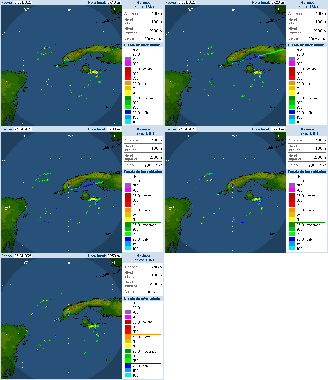
maybe something on the NW end of that convection. satellite and radar showing some signs... will see. typically you would see it develop under the convection. well more as a result of the convection.

Image
0 likes   
Note: If I make a post that is brief. Please refer back to previous posts for the analysis or reasoning. I do not re-write/qoute what my initial post said each time.
If there is nothing before... then just ask :)

Space & Atmospheric Physicist, Embry-Riddle Aeronautical University,
I believe the sky is falling...

User avatar
ROCK
Category 5
Category 5
Posts: 9484
Age: 54
Joined: Tue Aug 17, 2004 7:30 am
Location: Kemah, Texas

Re: NW Carribean / Southern GOM / BOC

#963 Postby ROCK » Thu Jun 21, 2012 12:10 pm

thats a deep storm also.....hurricane most likely...
0 likes   

Aric Dunn
Category 5
Category 5
Posts: 21238
Age: 42
Joined: Sun Sep 19, 2004 9:58 pm
Location: Ready for the Chase.
Contact:

Re: NW Carribean / Southern GOM / BOC

#964 Postby Aric Dunn » Thu Jun 21, 2012 12:12 pm

ROCK wrote:12Z CMC.....3 runs in a row now... :eek:


http://moe.met.fsu.edu/cgi-bin/cmctc2.c ... =Animation

this is also farther up the coast than last run...trof misses it...shunted west...


dont buy into that. it nearly makes landfall in the panhandle then New Orleans before wobbling around to the wsw then screams west. not likely.
0 likes   
Note: If I make a post that is brief. Please refer back to previous posts for the analysis or reasoning. I do not re-write/qoute what my initial post said each time.
If there is nothing before... then just ask :)

Space & Atmospheric Physicist, Embry-Riddle Aeronautical University,
I believe the sky is falling...

User avatar
TexWx
Category 1
Category 1
Posts: 370
Joined: Tue Aug 22, 2006 11:00 pm
Location: Pearland, Texas
Contact:

Re: NW Carribean / Southern GOM / BOC

#965 Postby TexWx » Thu Jun 21, 2012 12:13 pm

ROCK wrote:12Z CMC.....3 runs in a row now... :eek:


http://moe.met.fsu.edu/cgi-bin/cmctc2.c ... =Animation

this is also farther up the coast than last run...trof misses it...shunted west...


Talk about your beach erosion run....
0 likes   

User avatar
PTrackerLA
Category 5
Category 5
Posts: 5277
Age: 41
Joined: Thu Oct 10, 2002 8:40 pm
Location: Lafayette, LA

#966 Postby PTrackerLA » Thu Jun 21, 2012 12:14 pm

CMC takes it dangerously close to New Orleans that run :eek: . Would definitely have some coastal flooding issues with that scenario. The plot continues to thicken GIVE US AN INVEST ALREADY!!!!!!
0 likes   

User avatar
ROCK
Category 5
Category 5
Posts: 9484
Age: 54
Joined: Tue Aug 17, 2004 7:30 am
Location: Kemah, Texas

Re: NW Carribean / Southern GOM / BOC

#967 Postby ROCK » Thu Jun 21, 2012 12:16 pm

Aric Dunn wrote:
ROCK wrote:12Z CMC.....3 runs in a row now... :eek:


http://moe.met.fsu.edu/cgi-bin/cmctc2.c ... =Animation

this is also farther up the coast than last run...trof misses it...shunted west...


dont buy into that. it nearly makes landfall in the panhandle then New Orleans before wobbling around to the wsw then screams west. not likely.


:lol: nah I dont buy into any one model run..been here long enough on this planet to know better.....but it does make for good drama! :lol:
0 likes   

Aric Dunn
Category 5
Category 5
Posts: 21238
Age: 42
Joined: Sun Sep 19, 2004 9:58 pm
Location: Ready for the Chase.
Contact:

#968 Postby Aric Dunn » Thu Jun 21, 2012 12:16 pm

yeah when you look at the vorticity its all over the place with multiple vorts causing this to move erratically ... blah blah blah. my trash can of model runs is getting full.

http://moe.met.fsu.edu/cgi-bin/cmctc2.c ... =Animation
0 likes   
Note: If I make a post that is brief. Please refer back to previous posts for the analysis or reasoning. I do not re-write/qoute what my initial post said each time.
If there is nothing before... then just ask :)

Space & Atmospheric Physicist, Embry-Riddle Aeronautical University,
I believe the sky is falling...

User avatar
PTrackerLA
Category 5
Category 5
Posts: 5277
Age: 41
Joined: Thu Oct 10, 2002 8:40 pm
Location: Lafayette, LA

Re:

#969 Postby PTrackerLA » Thu Jun 21, 2012 12:18 pm

Aric Dunn wrote:yeah when you look at the vorticity its all over the place with multiple vorts causing this to move erratically ... blah blah blah. my trash can of model runs is getting full.

http://moe.met.fsu.edu/cgi-bin/cmctc2.c ... =Animation


Well I currently could identify multiple vorts in the gulf with this system right now. Seems like a classic June Gulf storm to me.
0 likes   

Aric Dunn
Category 5
Category 5
Posts: 21238
Age: 42
Joined: Sun Sep 19, 2004 9:58 pm
Location: Ready for the Chase.
Contact:

#970 Postby Aric Dunn » Thu Jun 21, 2012 12:25 pm

Still going with the GFS/EURO blend they have been persistent with it getting caught up in the trough. ... just looked at the 00z euro there some 90kt vectors as it re-emerges into the atlantic off JAX but the time jump was to large to see what it was at landfall. its was a hurricane the day before just south of Apalachicola
0 likes   
Note: If I make a post that is brief. Please refer back to previous posts for the analysis or reasoning. I do not re-write/qoute what my initial post said each time.
If there is nothing before... then just ask :)

Space & Atmospheric Physicist, Embry-Riddle Aeronautical University,
I believe the sky is falling...

User avatar
South Texas Storms
Professional-Met
Professional-Met
Posts: 4224
Joined: Thu Jun 24, 2010 12:28 am
Location: Houston, TX

Re: NW Carribean / Southern GOM / BOC

#971 Postby South Texas Storms » Thu Jun 21, 2012 12:26 pm

#NASA is referring to Gulf storm as "96L" which could mean NHC is preparing to upgrade. From Tim Heller Facebook page.
http://www.nasa.gov/mission_pages/hurri ... 2_96L.html
0 likes   

User avatar
LSU2001
S2K Supporter
S2K Supporter
Posts: 1711
Age: 57
Joined: Sat Sep 11, 2004 11:01 pm
Location: Cut Off, Louisiana

Re: NW Carribean / Southern GOM / BOC

#972 Postby LSU2001 » Thu Jun 21, 2012 12:27 pm

Hi All,
Guess it's time to start paying attention again. That CMC run would mean I would be taking a boat to work. LOL.
Anyway our local NWS is talking a bit about the system and the fact that we are currently experiencing some minor tidal flooding due to the persistent Southeast wind we have been having.
I sure look forward to reading all of your thoughts as this system evolves.
Tim

000
FXUS64 KLIX 211238
AFDLIX

AREA FORECAST DISCUSSION
NATIONAL WEATHER SERVICE NEW ORLEANS LA
738 AM CDT THU JUN 21 2012

SHORT TERM...
EAST FLOW IS EXPECTED TO CONTINUE THROUGH THE WEEK AS THE GULF SYSTEM
POSSIBLE DEVELOPS OR STRENGTHEN. FLOW MAY HAVE A MORE NORTHEASTERLY
COMPONENT. HOWEVER...WATER LEVELS MAY REMAIN ELEVATED AS THESE
WINDS MAY NOT ALLOW WATER LEVELS TO RECEDE ON TIDAL LAKES AND
BAYS. AT WAVELAND...EXTRA-TROPICAL STORM SURGE SHOWED LEVELS FOR THE
NEXT THREE HIGH TIDE CYCLES BETWEEN 3.3 TO 3.5 FEET. A FEW LOW
LYING ROADS IN HANCOCK COUNTY MAY EXPERIENCE MINOR OVERWASH EACH
AFTERNOON THROUGH SATURDAY. PRECIPITABLE WATER VALUE MAY SURGE UP
TO 1.8 INCHES EARLY FRIDAY WITH THE CLOSE PROXIMITY OF THE SYSTEM
POSSIBLY OVER THE GULF. SUBSIDENCE NORTHWEST OF THE SYSTEM MAY
MIGRATE FARTHER NORTH. AS A RESULT...SLIGHT RAIN CHANCE WILL
EXTEND ACROSS THE FORECAST AREA FOR FRIDAY AND BETTER CHANCES OF
RAIN ALONG THE COASTAL SECTIONS. 18
LINK: http://forecast.weather.gov/product.php ... glossary=1
0 likes   
Personal Forecast Disclaimer:
The posts in this forum are NOT official forecast and should not be used as such. They are NOT endorsed by any professional institution or storm2k.org. For official information, please refer to the NHC and NWS products.

User avatar
ROCK
Category 5
Category 5
Posts: 9484
Age: 54
Joined: Tue Aug 17, 2004 7:30 am
Location: Kemah, Texas

Re: NW Carribean / Southern GOM / BOC

#973 Postby ROCK » Thu Jun 21, 2012 12:27 pm

South Texas Storms wrote:#NASA is referring to Gulf storm as "96L" which could mean NHC is preparing to upgrade. From Tim Heller Facebook page.
http://www.nasa.gov/mission_pages/hurri ... 2_96L.html


finally....!!
0 likes   

Aric Dunn
Category 5
Category 5
Posts: 21238
Age: 42
Joined: Sun Sep 19, 2004 9:58 pm
Location: Ready for the Chase.
Contact:

Re: NW Carribean / Southern GOM / BOC

#974 Postby Aric Dunn » Thu Jun 21, 2012 12:29 pm

ROCK wrote:
South Texas Storms wrote:#NASA is referring to Gulf storm as "96L" which could mean NHC is preparing to upgrade. From Tim Heller Facebook page.
http://www.nasa.gov/mission_pages/hurri ... 2_96L.html


finally....!!


well its not official yet though. :(
0 likes   
Note: If I make a post that is brief. Please refer back to previous posts for the analysis or reasoning. I do not re-write/qoute what my initial post said each time.
If there is nothing before... then just ask :)

Space & Atmospheric Physicist, Embry-Riddle Aeronautical University,
I believe the sky is falling...

User avatar
cycloneye
Admin
Admin
Posts: 145292
Age: 68
Joined: Thu Oct 10, 2002 10:54 am
Location: San Juan, Puerto Rico

Re: NW Carribean / Southern GOM / BOC

#975 Postby cycloneye » Thu Jun 21, 2012 12:31 pm

Not yet but warming up! :)
0 likes   
Visit the Caribbean-Central America Weather Thread where you can find at first post web cams,radars
and observations from Caribbean basin members Click Here

User avatar
TropicalAnalystwx13
Category 5
Category 5
Posts: 2109
Age: 27
Joined: Tue Jul 19, 2011 8:20 pm
Location: Wilmington, NC
Contact:

#976 Postby TropicalAnalystwx13 » Thu Jun 21, 2012 12:39 pm

Up to 50%!

TROPICAL WEATHER OUTLOOK
NWS NATIONAL HURRICANE CENTER MIAMI FL
200 PM EDT THU JUN 21 2012

FOR THE NORTH ATLANTIC...CARIBBEAN SEA AND THE GULF OF MEXICO...

THE NATIONAL HURRICANE CENTER IS ISSUING ADVISORIES ON HURRICANE
CHRIS...LOCATED ABOUT 625 MILES SOUTHEAST OF CAPE RACE
NEWFOUNDLAND.

A BROAD AREA OF LOW PRESSURE CENTERED NEAR THE NORTHERN COAST OF THE
YUCATAN PENINSULA IS PRODUCING A LARGE AREA OF SHOWERS AND
THUNDERSTORMS EXTENDING FROM THE YUCATAN PENINSULA NORTHEASTWARD
ACROSS WESTERN CUBA TO SOUTHERN FLORIDA. UPPER-LEVEL WINDS ARE
FORECAST TO BECOME MORE CONDUCIVE FOR DEVELOPMENT DURING THE NEXT
DAY OR SO AS THIS DISTURBANCE MOVES SLOWLY NORTHWARD INTO THE
CENTRAL GULF OF MEXICO. THIS SYSTEM HAS A MEDIUM CHANCE...50
PERCENT
...OF BECOMING A TROPICAL CYCLONE DURING THE NEXT 48 HOURS.
BEYOND THAT TIME...CONDITIONS ARE EXPECTED TO REMAIN FAVORABLE FOR
DEVELOPMENT...AND INTERESTS ALONG THE ENTIRE UNITED STATES GULF
COAST SHOULD MONITOR THE PROGRESS OF THIS DISTURBANCE THROUGH THE
WEEKEND. HEAVY RAINS AND LOCALIZED FLOODING ARE POSSIBLE ACROSS
THE YUCATAN PENINSULA...WESTERN CUBA...AND SOUTHERN FLORIDA THROUGH
SATURDAY.

ELSEWHERE...TROPICAL CYCLONE FORMATION IS NOT EXPECTED DURING THE
NEXT 48 HOURS.

$$
FORECASTER BROWN
Last edited by TropicalAnalystwx13 on Thu Jun 21, 2012 12:40 pm, edited 1 time in total.
0 likes   

User avatar
ROCK
Category 5
Category 5
Posts: 9484
Age: 54
Joined: Tue Aug 17, 2004 7:30 am
Location: Kemah, Texas

Re: NW Carribean / Southern GOM / BOC

#977 Postby ROCK » Thu Jun 21, 2012 12:40 pm

well the EURO should be coming out in about 20 minutes....WXMN57 probably already has it though... :D Hopefully it will clear up some of this model madness....
0 likes   

User avatar
cycloneye
Admin
Admin
Posts: 145292
Age: 68
Joined: Thu Oct 10, 2002 10:54 am
Location: San Juan, Puerto Rico

Re: NW Carribean / Southern GOM / BOC

#978 Postby cycloneye » Thu Jun 21, 2012 12:40 pm

Up to 50%

TROPICAL WEATHER OUTLOOK
NWS NATIONAL HURRICANE CENTER MIAMI FL
200 PM EDT THU JUN 21 2012

FOR THE NORTH ATLANTIC...CARIBBEAN SEA AND THE GULF OF MEXICO...

THE NATIONAL HURRICANE CENTER IS ISSUING ADVISORIES ON HURRICANE
CHRIS...LOCATED ABOUT 625 MILES SOUTHEAST OF CAPE RACE
NEWFOUNDLAND.

A BROAD AREA OF LOW PRESSURE CENTERED NEAR THE NORTHERN COAST OF THE
YUCATAN PENINSULA IS PRODUCING A LARGE AREA OF SHOWERS AND
THUNDERSTORMS EXTENDING FROM THE YUCATAN PENINSULA NORTHEASTWARD
ACROSS WESTERN CUBA TO SOUTHERN FLORIDA. UPPER-LEVEL WINDS ARE
FORECAST TO BECOME MORE CONDUCIVE FOR DEVELOPMENT DURING THE NEXT
DAY OR SO AS THIS DISTURBANCE MOVES SLOWLY NORTHWARD INTO THE
CENTRAL GULF OF MEXICO. THIS SYSTEM HAS A MEDIUM CHANCE...50
PERCENT...OF BECOMING A TROPICAL CYCLONE DURING THE NEXT 48 HOURS.
BEYOND THAT TIME...CONDITIONS ARE EXPECTED TO REMAIN FAVORABLE FOR
DEVELOPMENT...AND INTERESTS ALONG THE ENTIRE UNITED STATES GULF
COAST SHOULD MONITOR THE PROGRESS OF THIS DISTURBANCE THROUGH THE
WEEKEND. HEAVY RAINS AND LOCALIZED FLOODING ARE POSSIBLE ACROSS
THE YUCATAN PENINSULA...WESTERN CUBA...AND SOUTHERN FLORIDA THROUGH
SATURDAY.

ELSEWHERE...TROPICAL CYCLONE FORMATION IS NOT EXPECTED DURING THE
NEXT 48 HOURS.

$$
FORECASTER BROWN
0 likes   
Visit the Caribbean-Central America Weather Thread where you can find at first post web cams,radars
and observations from Caribbean basin members Click Here

User avatar
Cainer
Tropical Storm
Tropical Storm
Posts: 188
Age: 34
Joined: Mon May 05, 2008 3:26 pm
Location: Yarmouth, Nova Scotia

#979 Postby Cainer » Thu Jun 21, 2012 12:40 pm

You beat me to it cycloneye :D. It's been a while since we've seen such a high percentage without an invest designation. Coming soon no doubt with that strong wording in the TWO.
Last edited by Cainer on Thu Jun 21, 2012 12:42 pm, edited 1 time in total.
0 likes   

Aric Dunn
Category 5
Category 5
Posts: 21238
Age: 42
Joined: Sun Sep 19, 2004 9:58 pm
Location: Ready for the Chase.
Contact:

#980 Postby Aric Dunn » Thu Jun 21, 2012 12:40 pm

ok 50% still no invest lol ..
0 likes   
Note: If I make a post that is brief. Please refer back to previous posts for the analysis or reasoning. I do not re-write/qoute what my initial post said each time.
If there is nothing before... then just ask :)

Space & Atmospheric Physicist, Embry-Riddle Aeronautical University,
I believe the sky is falling...


Return to “Talkin' Tropics”

Who is online

Users browsing this forum: cstrunk, Google Adsense [Bot] and 46 guests