12z CMC says bye.
http://moe.met.fsu.edu/cgi-bin/cmctc2.c ... =Animation
ATL: DEBBY - Post-Tropical
Moderator: S2k Moderators
-
cycloneye

- Admin

- Posts: 149291
- Age: 69
- Joined: Thu Oct 10, 2002 10:54 am
- Location: San Juan, Puerto Rico
Re: ATL: DEBBY - Models
0 likes
Visit the Caribbean-Central America Weather Thread where you can find at first post web cams,radars
and observations from Caribbean basin members Click Here
and observations from Caribbean basin members Click Here
-
Aric Dunn
- Category 5

- Posts: 21238
- Age: 43
- Joined: Sun Sep 19, 2004 9:58 pm
- Location: Ready for the Chase.
- Contact:
I would have to say, if you look that the 500mb heights to the north of debbie as she leaves florida and begins to slow and almost stall. its in a very precarious spot again and if something like that were to happen. its possible it could wobble back to the coast depending on how far east the ridging extends during that time frame.
0 likes
Note: If I make a post that is brief. Please refer back to previous posts for the analysis or reasoning. I do not re-write/qoute what my initial post said each time.
If there is nothing before... then just ask
Space & Atmospheric Physicist, Embry-Riddle Aeronautical University,
I believe the sky is falling...
If there is nothing before... then just ask
Space & Atmospheric Physicist, Embry-Riddle Aeronautical University,
I believe the sky is falling...
-
Aric Dunn
- Category 5
- Posts: 21238
- Age: 43
- Joined: Sun Sep 19, 2004 9:58 pm
- Location: Ready for the Chase.
- Contact:
well not surprised to see multiple vorts again.
0 likes
Note: If I make a post that is brief. Please refer back to previous posts for the analysis or reasoning. I do not re-write/qoute what my initial post said each time.
If there is nothing before... then just ask
Space & Atmospheric Physicist, Embry-Riddle Aeronautical University,
I believe the sky is falling...
If there is nothing before... then just ask
Space & Atmospheric Physicist, Embry-Riddle Aeronautical University,
I believe the sky is falling...
-
tolakram
- Admin
- Posts: 20179
- Age: 62
- Joined: Sun Aug 27, 2006 8:23 pm
- Location: Florence, KY (name is Mark)
Re: ATL: DEBBY - Models
12z GFS and Canadian


CMC dissipates Debbie after 96 hours


CMC dissipates Debbie after 96 hours
0 likes
M a r k
- - - - -
Join us in chat: Storm2K Chatroom Invite. Android and IOS apps also available.
The posts in this forum are NOT official forecasts and should not be used as such. Posts are NOT endorsed by any professional institution or STORM2K.org. For official information and forecasts, please refer to NHC and NWS products.


Re: ATL: DEBBY - Tropical Storm - Discussion
It seems like she's trying to organize.
0 likes
"People might not get all they work for in this world, but they must certainly work for all they get."- Frederick Douglass
-
tolakram
- Admin
- Posts: 20179
- Age: 62
- Joined: Sun Aug 27, 2006 8:23 pm
- Location: Florence, KY (name is Mark)
Re: ATL: DEBBY - Recon
000
URNT12 KNHC 251725
VORTEX DATA MESSAGE AL042012
A. 25/17:03:00Z
B. 29 deg 03 min N
085 deg 30 min W
C. 850 mb 1393 m
D. 33 kt
E. 225 deg 55 nm
F. 317 deg 25 kt
G. 226 deg 74 nm
H. EXTRAP 996 mb
I. 17 C / 1494 m
J. 20 C / 1491 m
K. 17 C / NA
L. NA
M. NA
N. 1345 / 8
O. 0.02 / 6 nm
P. AF309 0404A DEBBY OB 12
MAX FL WIND 57 KT SE QUAD 13:55:40Z
MAX OUTBOUND FL WIND 46 KT NW QUAD 17:20:00Z
SLP EXTRAP FROM 850 MB
;
0 likes
M a r k
- - - - -
Join us in chat: Storm2K Chatroom Invite. Android and IOS apps also available.
The posts in this forum are NOT official forecasts and should not be used as such. Posts are NOT endorsed by any professional institution or STORM2K.org. For official information and forecasts, please refer to NHC and NWS products.
- - - - -
Join us in chat: Storm2K Chatroom Invite. Android and IOS apps also available.
The posts in this forum are NOT official forecasts and should not be used as such. Posts are NOT endorsed by any professional institution or STORM2K.org. For official information and forecasts, please refer to NHC and NWS products.
-
northjaxpro

- S2K Supporter

- Posts: 8900
- Joined: Mon Sep 27, 2010 11:21 am
- Location: Jacksonville, FL
Re:
Aric Dunn wrote:I would have to say, if you look that the 500mb heights to the north of debbie as she leaves florida and begins to slow and almost stall. its in a very precarious spot again and if something like that were to happen. its possible it could wobble back to the coast depending on how far east the ridging extends during that time frame.
That is what is worrying me just a bit. This is a classic COL region Debby is caught in as she is stuck in between the Central U.S. ridge and the East Coast trough. I mean, even if Debby somehow managed to get just east of FL, the East Coast trough may lift out and leave her stuck until some type of "kicker" comes along to finally grab the system. I have a hard time seeing Debby staying intact through all of this though. We'll see.
I tell you one thing, Debby will rank for me and many others I'm sure of being one of the most perplexing storms to get a handle on that's for certain.
0 likes
NEVER, EVER SAY NEVER in the tropics and weather in general, and most importantly, with life itself!!
________________________________________________________________________________________
Fay 2008 Beryl 2012 Debby 2012 Colin 2016 Hermine 2016 Julia 2016 Matthew 2016 Irma 2017 Dorian 2019
________________________________________________________________________________________
Fay 2008 Beryl 2012 Debby 2012 Colin 2016 Hermine 2016 Julia 2016 Matthew 2016 Irma 2017 Dorian 2019
-
Aric Dunn
- Category 5
- Posts: 21238
- Age: 43
- Joined: Sun Sep 19, 2004 9:58 pm
- Location: Ready for the Chase.
- Contact:
Re: ATL: DEBBY - Tropical Storm - Discussion
AHS2011 wrote:It seems like she's trying to organize.
well it will take more time to moisten up the atmosphere again.
0 likes
Note: If I make a post that is brief. Please refer back to previous posts for the analysis or reasoning. I do not re-write/qoute what my initial post said each time.
If there is nothing before... then just ask
Space & Atmospheric Physicist, Embry-Riddle Aeronautical University,
I believe the sky is falling...
If there is nothing before... then just ask
Space & Atmospheric Physicist, Embry-Riddle Aeronautical University,
I believe the sky is falling...

Re: ATL: DEBBY - Tropical Storm - Discussion
Not a lot of wind around this circulation anymore. Tallahassee is near/under some of the deepest convection around the center itself and is only sustained at 16 mph.
0 likes

Re: ATL: DEBBY - Tropical Storm - Discussion
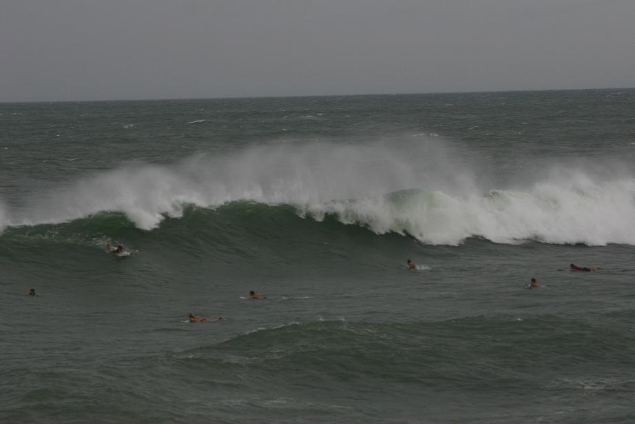
Here is a link to one of the larger set waces at the Pensacola Pier yesterday. Wow!!!
http://3.bp.blogspot.com/-ZE98Lu4YTZk/T-eTcV5vKkI/AAAAAAAAFhg/IF5OX7yag70/s1600/Sunday%20evening%2006242012%20169.JPG
http://3.bp.blogspot.com/-ZE98Lu4YTZk/T-eTcV5vKkI/AAAAAAAAFhg/IF5OX7yag70/s1600/Sunday%20evening%2006242012%20169.JPG
0 likes
The following post is NOT an official forecast and should not be used as such. It is just the opinion of the poster and may or may not be backed by sound meteorological data. It is NOT endorsed by any professional institution including storm2k.org For Official Information please refer to the NHC and NWS products.
-
gatorcane

- S2K Supporter
- Posts: 23708
- Age: 48
- Joined: Sun Mar 13, 2005 3:54 pm
- Location: Boca Raton, FL
Winds across peninsula Florida and adjacent waters. Notice the large area of sustained high winds off the west coast of Florida (big area of green and yellow shading). Strongest winds remaining offshore:

Some observation history from St. Pete-Clearwater airport showing some very breezy conditions:

http://www.weather.gov/data/obhistory/KPIE.html
Some observation history from St. Pete-Clearwater airport showing some very breezy conditions:
http://www.weather.gov/data/obhistory/KPIE.html
Last edited by gatorcane on Mon Jun 25, 2012 12:54 pm, edited 7 times in total.
0 likes

Re: ATL: DEBBY - Tropical Storm - Discussion
Pretty nice cirrus building with the flare.
Getting closer to the LLC now.
http://rammb.cira.colostate.edu/product ... 251145.jpg
http://www.ssd.noaa.gov/PS/TROP/floater ... -long.html
Getting closer to the LLC now.
http://rammb.cira.colostate.edu/product ... 251145.jpg
http://www.ssd.noaa.gov/PS/TROP/floater ... -long.html
0 likes
-
cycloneye
- Admin
- Posts: 149291
- Age: 69
- Joined: Thu Oct 10, 2002 10:54 am
- Location: San Juan, Puerto Rico
Re: ATL: DEBBY - Advisories
WTNT34 KNHC 251749
TCPAT4
BULLETIN
TROPICAL STORM DEBBY INTERMEDIATE ADVISORY NUMBER 9A
NWS NATIONAL HURRICANE CENTER MIAMI FL AL042012
100 PM CDT MON JUN 25 2012
...DEBBY MOVING SLOWLY NORTHEASTWARD...HEAVY RAINS CONTINUE OVER
PORTIONS OF FLORIDA...
SUMMARY OF 100 PM CDT...1800 UTC...INFORMATION
----------------------------------------------
LOCATION...29.0N 85.2W
ABOUT 50 MI...80 KM SSW OF APALACHICOLA FLORIDA
MAXIMUM SUSTAINED WINDS...45 MPH...75 KM/H
PRESENT MOVEMENT...NE OR 40 DEGREES AT 5 MPH...8 KM/H
MINIMUM CENTRAL PRESSURE...995 MB...29.38 INCHES
WATCHES AND WARNINGS
--------------------
CHANGES WITH THIS ADVISORY...
NONE.
SUMMARY OF WATCHES AND WARNINGS IN EFFECT...
A TROPICAL STORM WARNING IS IN EFFECT FOR...
* THE FLORIDA GULF COAST FROM DESTIN TO ENGLEWOOD
FOR STORM INFORMATION SPECIFIC TO YOUR AREA...INCLUDING POSSIBLE
INLAND WATCHES AND WARNINGS...PLEASE MONITOR PRODUCTS ISSUED BY
YOUR LOCAL NATIONAL WEATHER SERVICE FORECAST OFFICE.
DISCUSSION AND 48-HOUR OUTLOOK
------------------------------
DEBBY IS A LARGE TROPICAL CYCLONE...WITH THE STRONGEST WINDS AND
MUCH OF THE HEAVIEST RAINFALL WELL REMOVED FROM THE CENTER OF
CIRCULATION.
AT 100 PM CDT...1800 UTC...THE CENTER OF TROPICAL STORM DEBBY WAS
LOCATED NEAR LATITUDE 29.0 NORTH...LONGITUDE 85.2 WEST. DEBBY IS
MOVING TOWARD THE NORTHEAST NEAR 5 MPH...8 KM/H. A SLOW MOTION
TOWARD THE NORTHEAST OR EAST-NORTHEAST IS EXPECTED DURING THE NEXT
COUPLE OF DAYS.
MAXIMUM SUSTAINED WINDS REMAIN NEAR 45 MPH...75 KM/H...WITH HIGHER
GUSTS. LITTLE CHANGE IN STRENGTH IS EXPECTED DURING THE NEXT DAY OR
TWO.
TROPICAL-STORM-FORCE WINDS EXTEND OUTWARD UP TO 230 MILES...370
KM...MAINLY TO THE SOUTHEAST OF THE CENTER.
THE ESTIMATED MINIMUM CENTRAL PRESSURE IS 995 MB...29.38 INCHES.
HAZARDS AFFECTING LAND
----------------------
WIND...TROPICAL STORM CONDITIONS WILL CONTINUE OVER PORTIONS OF
THE FLORIDA GULF COAST TODAY.
STORM SURGE...THE COMBINATION OF A STORM SURGE AND THE TIDE WILL
CAUSE NORMALLY DRY AREAS NEAR THE COAST TO BE FLOODED BY RISING
WATERS. THE WATER COULD REACH THE FOLLOWING DEPTHS ABOVE GROUND AT
THE TIMES OF HIGH TIDE OVER THE NEXT COUPLE OF DAYS...
APALACHEE BAY TO WACCASASSA BAY...3 TO 5 FT
FLORIDA WEST COAST SOUTH OF WACCASASSA BAY...1 TO 3 FT
SOUTHEASTERN LOUISIANA EASTWARD TO APALACHEE BAY...1 TO 3 FT
THE DEEPEST WATER WILL OCCUR ALONG THE IMMEDIATE COAST IN AREAS OF
ONSHORE FLOW. SURGE-RELATED FLOODING DEPENDS ON THE RELATIVE
TIMING OF THE SURGE AND THE TIDAL CYCLE...AND CAN VARY GREATLY OVER
SHORT DISTANCES. FOR INFORMATION SPECIFIC TO YOUR AREA...PLEASE
SEE PRODUCTS ISSUED BY YOUR LOCAL NATIONAL WEATHER SERVICE OFFICE.
RAINFALL...STORM TOTAL ACCUMULATIONS OF 10 TO 20 INCHES ARE EXPECTED
ACROSS MUCH OF NORTHERN AND CENTRAL FLORIDA...WITH A LOCAL MAXIMUM
OF 25 INCHES POSSIBLE. STORM TOTAL ACCUMULATIONS OF 5 TO 15 INCHES
ARE POSSIBLE ACROSS COASTAL SOUTHEASTERN GEORGIA AND EXTREME
SOUTHEASTERN SOUTH CAROLINA.
TORNADOES...A FEW TORNADOES ARE POSSIBLE TODAY ACROSS THE EASTERN
FLORIDA PANHANDLE...THE FLORIDA PENINSULA...AND SOUTHERN GEORGIA.
NEXT ADVISORY
-------------
NEXT COMPLETE ADVISORY...400 PM CDT.
$$
FORECASTER KIMBERLAIN/FRANKLIN
0 likes
Visit the Caribbean-Central America Weather Thread where you can find at first post web cams,radars
and observations from Caribbean basin members Click Here
and observations from Caribbean basin members Click Here
-
SeminoleWind

- Category 1

- Posts: 359
- Age: 51
- Joined: Wed Jun 02, 2010 8:37 pm
- Location: Lake County Florida
looks as if Debby is trying to wash out some of that dry air
0 likes
This post is NOT an official forecast and should not be used as such. It is just the opinion of the poster and may or may not be backed by sound meteorological data. It is NOT endorsed by any professional institution including storm2k.org For Official Information please refer to the NHC and NWS products.
Re: ATL: DEBBY - Tropical Storm - Discussion
Anti-cyclone moving a bit closer and ULL moving a bit farther away.
http://tropic.ssec.wisc.edu/real-time/w ... oom=&time=
http://tropic.ssec.wisc.edu/real-time/w ... oom=&time=
http://tropic.ssec.wisc.edu/real-time/w ... oom=&time=
http://tropic.ssec.wisc.edu/real-time/w ... oom=&time=
0 likes
-
cycloneye
- Admin
- Posts: 149291
- Age: 69
- Joined: Thu Oct 10, 2002 10:54 am
- Location: San Juan, Puerto Rico
Re: ATL: DEBBY - Advisories
BULLETIN - IMMEDIATE BROADCAST REQUESTED
TORNADO WATCH OUTLINE UPDATE FOR WT 427
NWS STORM PREDICTION CENTER NORMAN OK
150 PM EDT MON JUN 25 2012
TORNADO WATCH 427 IS IN EFFECT UNTIL 1100 PM EDT FOR THE
FOLLOWING LOCATIONS
FLC001-003-007-009-015-017-019-021-023-027-029-031 -035-041-043-
047-049-051-053-055-057-061-065-067-069-071-073-07 5-079-081-083-
085-089-093-095-097-099-101-103-105-107-109-111-11 5-117-119-121-
123-125-127-129-260300-
/O.NEW.KWNS.TO.A.0427.120625T1750Z-120626T0300Z/
FL
. FLORIDA COUNTIES INCLUDED ARE
ALACHUA BAKER BRADFORD
BREVARD CHARLOTTE CITRUS
CLAY COLLIER COLUMBIA
DESOTO DIXIE DUVAL
FLAGLER GILCHRIST GLADES
HAMILTON HARDEE HENDRY
HERNANDO HIGHLANDS HILLSBOROUGH
INDIAN RIVER JEFFERSON LAFAYETTE
LAKE LEE LEON
LEVY MADISON MANATEE
MARION MARTIN NASSAU
OKEECHOBEE ORANGE OSCEOLA
PALM BEACH PASCO PINELLAS
POLK PUTNAM SARASOTA
SEMINOLE ST. JOHNS ST. LUCIE
SUMTER SUWANNEE TAYLOR
UNION VOLUSIA WAKULLA
AMZ452-454-550-552-555-610-650-GMZ656-730-765-830- 850-853-856-
260300-
/O.NEW.KWNS.TO.A.0427.120625T1750Z-120626T0300Z/
CW
. ADJACENT COASTAL WATERS INCLUDED ARE
COASTAL WATERS FROM FERNANDINA BEACH TO ST. AUGUSTINE FL OUT 20
NM
COASTAL WATERS FROM ST. AUGUSTINE TO FLAGLER BEACH FL OUT 20 NM
FLAGLER BEACH TO VOLUSIA-BREVARD COUNTY LINE 0-20 NM
VOLUSIA-BREVARD COUNTY LINE TO SEBASTIAN INLET 0-20 NM
SEBASTIAN INLET TO JUPITER INLET 0-20 NM
LAKE OKEECHOBEE
COASTAL WATERS FROM JUPITER INLET TO DEERFIELD BEACH FL OUT 20 NM
COASTAL WATERS FROM CHOKOLOSKEE TO BONITA BEACH FL OUT 20 NM
APALACHEE BAY OR COASTAL WATERS FROM KEATON BEACH TO OCHLOCKONEE
RIVER FL OUT TO 20 NM
COASTAL WATERS FROM SUWANNEE RIVER TO KEATON BEACH OUT 20 NM
TAMPA BAY WATERS
COASTAL WATERS FROM TARPON SPRINGS TO SUWANNEE RIVER FL OUT 20 NM
COASTAL WATERS FROM ENGLEWOOD TO TARPON SPRINGS FL OUT 20 NM
COASTAL WATERS FROM BONITA BEACH TO ENGLEWOOD FL OUT 20 NM
ATTN...WFO...JAX...TBW...TAE...MFL...MLB...
0 likes
Visit the Caribbean-Central America Weather Thread where you can find at first post web cams,radars
and observations from Caribbean basin members Click Here
and observations from Caribbean basin members Click Here
-
seaswing

- S2K Supporter
- Posts: 561
- Joined: Sun Aug 31, 2003 11:56 am
- Location: High Springs, FL/just NW of Gainesville
Re:
Jevo wrote:From Twitter:
@TWC_Shawn: The Governor of Florida declares a State of Emergency due to Tropical Storm #Debby. No Nat'l Guard deployment at this time. #FLwx.
Glad to hear he went ahead and did this. Until he does it, no state or federal offices, schools, etc. can close.
0 likes
Re: ATL: DEBBY - Tropical Storm - Discussion
Wind field expanding. Few more 60 + gusts near Pt Charlotte / Venice here in last hour
"If "that N Quad cluster is a reflection of the center - and gets entrained - should have rapid intensification
http://www.ssd.noaa.gov/PS/TROP/floater ... -long.html
"If "that N Quad cluster is a reflection of the center - and gets entrained - should have rapid intensification
http://www.ssd.noaa.gov/PS/TROP/floater ... -long.html
0 likes
Who is online
Users browsing this forum: No registered users and 17 guests