

ATL: ERNESTO - Post-Tropical
Moderator: S2k Moderators
-
Hurricaneman

- Category 5

- Posts: 7404
- Age: 45
- Joined: Tue Aug 31, 2004 3:24 pm
- Location: central florida
Re:
There is a clear weakness in the ridge in this run, does this try to go for it or does this not get fully picked up and goes west into Texas or Mexico will be the question
The posts in this forum are NOT official forecast and should not be used as such. They are just the opinion of the poster and may or may not be backed by sound meteorological data. They are NOT endorsed by any professional institution or storm2k.org. For official information, please refer to the NHC and NWS products
0 likes

Re: ATL: FIVE - Models
got to be seeing the shear....I would think...but the SHIPS forecast was pretty mundane. Not sure why it wouldnt take off since it would be over some of the hottest ssts in the basin...
0 likes

Re: ATL: FIVE - Tropical Depression
MiamiensisWx wrote:Personal Forecast Disclaimer:
The posts in this forum are NOT official forecast and should not be used as such. They are just the opinion of the poster and may or may not be backed by sound meteorological data. They are NOT endorsed by any professional institution or storm2k.org. For official information, please refer to the NHC and NWS products.
I would also like to aver that most systems which are on the cusp of rapid intensification, or even steady strengthening, usually show marked characteristics as such...namely, unrestricted or expanding outflow in the N and/or S quadrants, thereby forming a dual outflow channel; ample surrounding moisture at mid-atmospheric levels / 700 mb; and a well-coordinated, vertically stacked circulation at the low and mid-levels, which allows the system to deepen and further tighten / strengthen its low-level vorticity. Equally true is that systems about to dissipate usually show the opposite trends, and that there are common trends: the models forecasted a deepening or a track that was not supported by climatology in a given type of seasonal environment, such as a year with weak Niño conditions by August and a persistent vortex over Canada, both of which tend to result in more upper-level lows, more stable air, and more shear. Also, years with early-season development north of the tropics tend to discourage development in certain areas of the tropics relative to the tracks of the early-season storms, which turned east this year, as in the case of Debby, due to the strong Canadian vortex and the East Coast trough / Plains ridge set-up. So, climatology was really against this system from the beginning, but because the most sophisticated dynamical models analyze the initial conditions and take into account local factors, they often forecast more intensification and more northward tracks, or even falsely prefigure development, in cases such as that of TD 5.
As an aside, the weaker intensity over the next few days makes a track south of Barbados more probable.
Storm2k Disclaimer added
Did you mail this information to the NHC? I don't like what is stated here or agree with it as it sounds like Tropical Storm Ana from 2009 which was garbage. Good to see you on here again.
RL3AO wrote:I swear this happens every time with these CV systems
Convection pops - Why isn't this a TD/TS? It looks amazing. Could be a hurricane within 36 hours.
Convection wanes - Going to dissipate by morning. Looks terrible.
Convection redevelops - Why isn't this a tropical storm yet? Looks great. OMGZZZZZZZZZ IS THAT AN EYE?
I've noticed this too.
0 likes
-
SeminoleWind

- Category 1

- Posts: 359
- Age: 51
- Joined: Wed Jun 02, 2010 8:37 pm
- Location: Lake County Florida
So if it starts to really gain strength around Jamaica this could get picked up and send it right into central or eastern Gulf?
0 likes
This post is NOT an official forecast and should not be used as such. It is just the opinion of the poster and may or may not be backed by sound meteorological data. It is NOT endorsed by any professional institution including storm2k.org For Official Information please refer to the NHC and NWS products.
-
Kingarabian

- S2K Supporter

- Posts: 16314
- Joined: Sat Aug 08, 2009 3:06 am
- Location: Honolulu, Hawaii
-
Rgv20

- S2K Supporter
- Posts: 2466
- Age: 39
- Joined: Wed Jan 05, 2011 5:42 pm
- Location: Edinburg/McAllen Tx
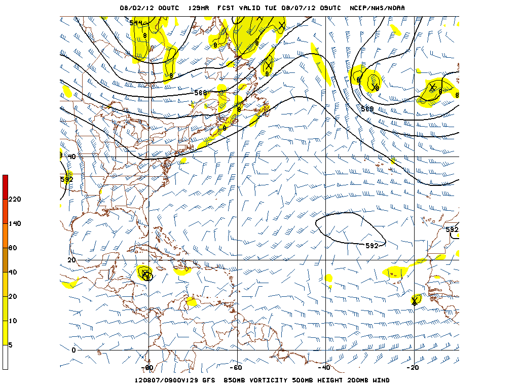
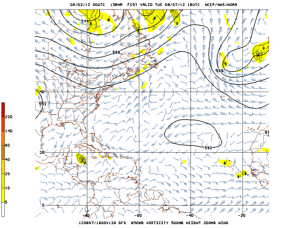
Thru Wednesday Morning tonight's 0zGFS is almost identical to the 18z with the position of TD5.
156hrs
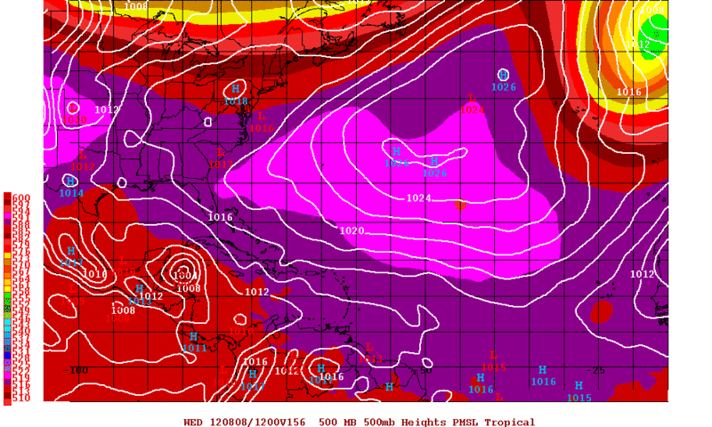
156hrs
0 likes
The following post is NOT an official forecast and should not be used as such. It is just the opinion of the poster and may or may not be backed by sound meteorological data. It is NOT endorsed by any professional institution including storm2k.org For Official Information please refer to the NHC and NWS products.
-
Wx_Warrior
- Category 5
- Posts: 2718
- Joined: Thu Aug 03, 2006 3:58 pm
- Location: Beaumont, TX

-
Kingarabian
- S2K Supporter
- Posts: 16314
- Joined: Sat Aug 08, 2009 3:06 am
- Location: Honolulu, Hawaii
-
Kingarabian
- S2K Supporter
- Posts: 16314
- Joined: Sat Aug 08, 2009 3:06 am
- Location: Honolulu, Hawaii

-
cycloneye

- Admin

- Posts: 148802
- Age: 69
- Joined: Thu Oct 10, 2002 10:54 am
- Location: San Juan, Puerto Rico
Re: ATL: FIVE - Models
Yucatan Peninsula into BOC.
0 likes
Visit the Caribbean-Central America Weather Thread where you can find at first post web cams,radars
and observations from Caribbean basin members Click Here
and observations from Caribbean basin members Click Here

-
Wx_Warrior
- Category 5
- Posts: 2718
- Joined: Thu Aug 03, 2006 3:58 pm
- Location: Beaumont, TX
-
Kingarabian
- S2K Supporter
- Posts: 16314
- Joined: Sat Aug 08, 2009 3:06 am
- Location: Honolulu, Hawaii
Re:
Wx_Warrior wrote:We going to have a player here or does Mr. GFS say "viva la mexico" on the 0z?
Viva La Mexico
Into die @ 216hrs.

0 likes
RIP Kobe Bryant
Re: ATL: FIVE - Models
186hr for the GFS is la la land, IMO......but it is showing something similar to the EURO with a BOC solution...
0 likes
Who is online
Users browsing this forum: No registered users and 48 guests