ATL: ERNESTO - Post-Tropical

Moderator: S2k Moderators

Message
Author
Sanibel
Category 5
Category 5
Posts: 10375
Joined: Mon Aug 30, 2004 11:06 pm
Location: Offshore SW Florida

Re: ATL: ERNESTO - Tropical Storm

#2781 Postby Sanibel » Sat Aug 04, 2012 8:47 pm

wxman57 wrote:I think the gear shift was into reverse...


Watch the little foot it just grew. If it tails into a band, probably intensification.


I still say it should strengthen west of Jamaica like most storms do.
0 likes   

User avatar
Dave
Retired Staff
Retired Staff
Posts: 13442
Age: 74
Joined: Tue Aug 01, 2006 3:57 pm
Location: Milan Indiana
Contact:

#2782 Postby Dave » Sat Aug 04, 2012 8:47 pm

000
URNT15 KNHC 050143
AF307 0505A ERNESTO HDOB 23 20120805
013500 1502N 07207W 8430 01572 0083 +197 +140 161006 006 018 003 00
013530 1503N 07209W 8429 01573 0085 +193 +155 129004 005 017 001 00
013600 1505N 07210W 8433 01567 0085 +190 +172 135006 007 016 002 00
013630 1506N 07211W 8427 01573 0089 +180 +180 130006 007 015 003 01
013700 1507N 07212W 8433 01568 0085 +187 +175 149003 005 019 002 00
013730 1508N 07214W 8430 01569 0083 +190 +165 124001 003 020 002 00
013800 1509N 07215W 8426 01573 0082 +189 +169 113002 003 018 004 00
013830 1511N 07216W 8431 01568 0081 +190 +171 141003 004 021 003 00
013900 1512N 07217W 8432 01565 0076 +201 +153 115003 004 018 003 00
013930 1513N 07218W 8432 01566 0072 +208 +144 087005 007 018 002 00
014000 1514N 07220W 8425 01573 0071 +211 +143 089009 011 014 003 00
014030 1515N 07221W 8429 01568 0071 +210 +145 085016 021 014 003 00
014100 1516N 07222W 8433 01567 0072 +212 +142 078025 029 016 003 00
014130 1518N 07224W 8430 01571 0074 +211 +142 065027 029 016 003 00
014200 1519N 07225W 8430 01571 0073 +210 +138 059025 025 017 002 00
014230 1520N 07226W 8425 01576 0075 +206 +146 057025 025 020 003 00
014300 1521N 07228W 8430 01569 0078 +202 +152 061026 027 023 002 00
014330 1522N 07229W 8428 01573 0078 +201 +157 064027 027 022 003 00
014400 1524N 07230W 8432 01569 0080 +198 +162 065027 027 024 002 00
014430 1525N 07231W 8429 01577 0085 +195 +169 065028 029 022 003 00
$$
;

1007.1 mb's - extrap: 1007 mb
0 likes   

Shuriken

Re: ATL: ERNESTO - Tropical Storm

#2783 Postby Shuriken » Sat Aug 04, 2012 8:48 pm

hurricanes1234 wrote:Shuriken, if you take a moment and read my comment properly, I said it was slightly less defined in my opinion.
You initially described it as "poorly defined"; and I replied that that is/was not that case, and believe that can be objectively determined (i.e., take it out of the realm of opinion into fact) as well by comparison to other storms of similar intensity. Ernesto already had a large outflow canopy at dawn this morning, and it quickly got bigger during the day as 200mb exhausting strongly overrode the area for all but a few hours during the diurnal maxima.

Cirrus outriders have now reached eastern Jamaica (and I can faintly see the front of the 200mb clear-air outflow boundary advancing all the way to 80W): http://www.ssd.noaa.gov/goes/east/carb/flash-wv.html
Last edited by Shuriken on Sat Aug 04, 2012 8:49 pm, edited 1 time in total.
0 likes   

hurricanes1234
Category 5
Category 5
Posts: 2907
Joined: Sat Jul 28, 2012 6:19 pm
Location: Trinidad and Tobago

Re: ATL: ERNESTO - Tropical Storm

#2784 Postby hurricanes1234 » Sat Aug 04, 2012 8:49 pm

Sanibel wrote:
wxman57 wrote:I think the gear shift was into reverse...


Watch the little foot it just grew. If it tails into a band, probably intensification.


I still say it should strengthen west of Jamaica like most storms do.


We may soon be tracking another Dean, just not as powerful though. :)

____________
The posts in this forum are NOT official forecast and should not be used as such. They are just the opinion of the poster and may or may not be backed by sound meteorological data. They are NOT endorsed by any professional institution or storm2k.org. For official information, please refer to the NHC and NWS products.
0 likes   
PLEASE NOTE: With the exception of information from weather agencies that I may copy and paste here, my posts will NEVER be official, since I am NOT a meteorologist. They are solely my amateur opinion, and may or may not be accurate. Therefore, please DO NOT use them as official details, particularly when making important decisions. Thank you.

Sanibel
Category 5
Category 5
Posts: 10375
Joined: Mon Aug 30, 2004 11:06 pm
Location: Offshore SW Florida

Re: ATL: ERNESTO - Tropical Storm

#2785 Postby Sanibel » Sat Aug 04, 2012 8:51 pm

Yesterday's bursts could have been delayed strengthening from the Lessers. Today the east Caribbean zone caught up with it as it "skipped" further west waiting for better conditions to continue developing.
0 likes   

hurricanes1234
Category 5
Category 5
Posts: 2907
Joined: Sat Jul 28, 2012 6:19 pm
Location: Trinidad and Tobago

Re: ATL: ERNESTO - Tropical Storm

#2786 Postby hurricanes1234 » Sat Aug 04, 2012 8:55 pm

Shuriken wrote:
hurricanes1234 wrote:Shuriken, if you take a moment and read my comment properly, I said it was slightly less defined in my opinion.
You initially described it as "poorly defined"; and I replied that that is/was not that case, and believe that can be objectively determined (i.e., take it out of the realm of opinion into fact) as well by comparison to other storms of similar intensity. Ernesto already had a large outflow canopy at dawn this morning, and it quickly got bigger during the day as 200mb exhausting strongly overrode the area for all but a few hours during the diurnal maxima.

Cirrus outriders have now reached eastern Jamaica (and I can faintly see the front of the 200mb clear-air outflow boundary advancing all the way to 80W): http://www.ssd.noaa.gov/goes/east/carb/flash-wv.html


Hopefully, when Ernesto passes south of Jamaica, its rainbands are not all that deep. Otherwise, they may be in for some trouble. Sometimes, particularly with intensifying 70 mph tropical storms, they tend to become more compact and their rainbands diminish temporarily, so let us hope that's the case. Also, another tropical wave is emerging from the coast of Africa.
0 likes   
PLEASE NOTE: With the exception of information from weather agencies that I may copy and paste here, my posts will NEVER be official, since I am NOT a meteorologist. They are solely my amateur opinion, and may or may not be accurate. Therefore, please DO NOT use them as official details, particularly when making important decisions. Thank you.

User avatar
littlevince
S2K Supporter
S2K Supporter
Posts: 768
Joined: Fri Oct 21, 2005 10:45 am
Location: Portugal

Re: ATL: ERNESTO - Recon

#2787 Postby littlevince » Sat Aug 04, 2012 8:56 pm

Image
Last edited by littlevince on Sat Aug 04, 2012 9:00 pm, edited 2 times in total.
0 likes   

User avatar
Dave
Retired Staff
Retired Staff
Posts: 13442
Age: 74
Joined: Tue Aug 01, 2006 3:57 pm
Location: Milan Indiana
Contact:

#2788 Postby Dave » Sat Aug 04, 2012 8:56 pm

000
URNT15 KNHC 050153
AF307 0505A ERNESTO HDOB 24 20120805
014500 1526N 07233W 8429 01578 0089 +194 +166 065032 033 023 003 00
014530 1527N 07234W 8429 01578 0089 +194 +165 067033 034 026 002 00
014600 1529N 07235W 8429 01578 0090 +192 +166 069033 034 025 003 00
014630 1530N 07237W 8430 01578 0093 +190 +170 071034 034 028 002 00
014700 1531N 07238W 8429 01580 0094 +190 +167 070034 035 028 002 00
014730 1532N 07239W 8430 01580 0095 +190 +169 071034 035 030 002 00
014800 1534N 07240W 8429 01583 0098 +190 +167 070036 036 029 004 00
014830 1535N 07242W 8432 01580 0097 +190 +169 070036 037 029 004 00
014900 1536N 07243W 8430 01582 0097 +190 +168 072038 039 030 003 00
014930 1537N 07244W 8432 01582 0096 +194 +164 071040 040 031 002 00
015000 1539N 07246W 8429 01585 0097 +192 +164 071039 040 031 004 00
015030 1540N 07247W 8430 01583 0100 +189 +165 073039 040 031 003 00
015100 1541N 07248W 8430 01587 0102 +190 +165 071036 038 031 003 00
015130 1542N 07249W 8429 01589 0104 +188 +163 072036 036 031 003 00
015200 1544N 07251W 8429 01589 0103 +190 +162 075038 039 032 002 00
015230 1545N 07252W 8432 01587 0106 +190 +163 075040 040 033 002 00
015300 1546N 07253W 8430 01588 0104 +194 +155 075042 042 031 004 00
015330 1548N 07255W 8430 01590 0105 +193 +156 073041 041 031 002 00
015400 1549N 07256W 8430 01590 0107 +190 +156 074042 043 030 003 00
015430 1550N 07257W 8428 01594 0111 +190 +156 075042 043 030 003 00
$$
;
0 likes   

tolakram
Admin
Admin
Posts: 20012
Age: 62
Joined: Sun Aug 27, 2006 8:23 pm
Location: Florence, KY (name is Mark)

Re: ATL: ERNESTO - Recon Discussions - Comments - Questions

#2789 Postby tolakram » Sat Aug 04, 2012 8:58 pm

I am most likely out for the rest of the night. Good luck!
0 likes   
M a r k
- - - - -
Join us in chat: Storm2K Chatroom Invite. Android and IOS apps also available.

The posts in this forum are NOT official forecasts and should not be used as such. Posts are NOT endorsed by any professional institution or STORM2K.org. For official information and forecasts, please refer to NHC and NWS products.

User avatar
cycloneye
Admin
Admin
Posts: 145721
Age: 68
Joined: Thu Oct 10, 2002 10:54 am
Location: San Juan, Puerto Rico

Re:

#2790 Postby cycloneye » Sat Aug 04, 2012 8:58 pm

CrazyC83 wrote:I think we might be seeing a center relocation in process right now. Will it relocate under the convection?

You think that is what's going on?
0 likes   
Visit the Caribbean-Central America Weather Thread where you can find at first post web cams,radars
and observations from Caribbean basin members Click Here

User avatar
Dave
Retired Staff
Retired Staff
Posts: 13442
Age: 74
Joined: Tue Aug 01, 2006 3:57 pm
Location: Milan Indiana
Contact:

#2791 Postby Dave » Sat Aug 04, 2012 9:00 pm

We've got you covered Mark, thanks for your help. Vince is on graphics & I'm on hdobs for awhile.
0 likes   

User avatar
Portastorm
Storm2k Moderator
Storm2k Moderator
Posts: 9914
Age: 63
Joined: Fri Jul 11, 2003 9:16 am
Location: Round Rock, TX
Contact:

Re: ATL: ERNESTO - Tropical Storm

#2792 Postby Portastorm » Sat Aug 04, 2012 9:00 pm

Sanibel wrote:Yesterday's bursts could have been delayed strengthening from the Lessers. Today the east Caribbean zone caught up with it as it "skipped" further west waiting for better conditions to continue developing.


Yep ... and until Ernesto looks better vertically and less tilted and slows down a bit, it is hard to imagine him strengthening much at all.
0 likes   
Any forecasts under my name are to be taken with a grain of salt. Get your best forecasts from the National Weather Service and National Hurricane Center.

tolakram
Admin
Admin
Posts: 20012
Age: 62
Joined: Sun Aug 27, 2006 8:23 pm
Location: Florence, KY (name is Mark)

Re: ATL: ERNESTO - Tropical Storm

#2793 Postby tolakram » Sat Aug 04, 2012 9:00 pm

From the recon thread

Image

Again, no west winds. Not sure this is a TS anymore. Recon sure is interesting this time around.
0 likes   
M a r k
- - - - -
Join us in chat: Storm2K Chatroom Invite. Android and IOS apps also available.

The posts in this forum are NOT official forecasts and should not be used as such. Posts are NOT endorsed by any professional institution or STORM2K.org. For official information and forecasts, please refer to NHC and NWS products.

User avatar
Rgv20
S2K Supporter
S2K Supporter
Posts: 2466
Age: 39
Joined: Wed Jan 05, 2011 5:42 pm
Location: Edinburg/McAllen Tx

#2794 Postby Rgv20 » Sat Aug 04, 2012 9:02 pm

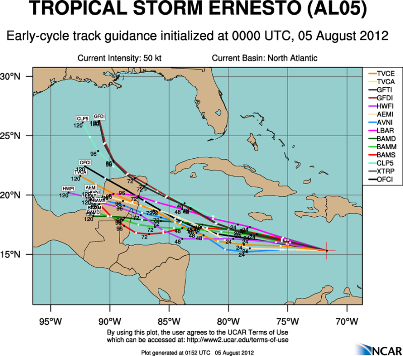
0z Model Runs

Image


18zGFS Individual Ensemble Tracks

Image
0 likes   
The following post is NOT an official forecast and should not be used as such. It is just the opinion of the poster and may or may not be backed by sound meteorological data. It is NOT endorsed by any professional institution including storm2k.org For Official Information please refer to the NHC and NWS products.

Shuriken

Re: ATL: ERNESTO - Tropical Storm

#2795 Postby Shuriken » Sat Aug 04, 2012 9:02 pm

Sanibel wrote:It's a little early in the season for a buzzsaw
Hurricane Allen was a 190mph cat-5 on August 5, 1980 while southeast of Jamaica (ironically that is tomorrow's date, and not far from where Ernesto should be then -- of course Allen had already been a hurricane since the LAs).

Hurricane Emily became a cat-5 on July 16 in 2005.
Last edited by Shuriken on Sat Aug 04, 2012 9:02 pm, edited 1 time in total.
0 likes   

User avatar
Hurricaneman
Category 5
Category 5
Posts: 7359
Age: 45
Joined: Tue Aug 31, 2004 3:24 pm
Location: central florida

Re: ATL: ERNESTO - Tropical Storm

#2796 Postby Hurricaneman » Sat Aug 04, 2012 9:02 pm

I see a circulation on the recon, but on the SW side of the convection

The posts in this forum are NOT official forecast and should not be used as such. They are just the opinion of the poster and may or may not be backed by sound meteorological data. They are NOT endorsed by any professional institution or storm2k.org. For official information, please refer to the NHC and NWS products
0 likes   

User avatar
littlevince
S2K Supporter
S2K Supporter
Posts: 768
Joined: Fri Oct 21, 2005 10:45 am
Location: Portugal

Re: ATL: ERNESTO - Recon

#2797 Postby littlevince » Sat Aug 04, 2012 9:03 pm

Image
0 likes   

User avatar
Dave
Retired Staff
Retired Staff
Posts: 13442
Age: 74
Joined: Tue Aug 01, 2006 3:57 pm
Location: Milan Indiana
Contact:

#2798 Postby Dave » Sat Aug 04, 2012 9:03 pm

000
URNT12 KNHC 050159
VORTEX DATA MESSAGE AL052012
A. 05/01:39:30Z
B. 15 deg 13 min N
072 deg 18 min W
C. 850 mb 1497 m
D. 25 kt
E. 135 deg 30 nm
F. 173 deg 39 kt
G. 135 deg 81 nm
H. 1007 mb
I. 15 C / 1572 m
J. 21 C / 1567 m
K. 15 C / NA
L. NA
M. NA
N. 1345 / 8
O. 0.02 / 4 nm
P. AF307 0505A ERNESTO OB 08
MAX FL WIND 44 KT E QUAD 23:21:30Z
MAX OUTBOUND FL WIND 43 KT NW QUAD 01:54:00Z
0 likes   

User avatar
vbhoutex
Storm2k Executive
Storm2k Executive
Posts: 29113
Age: 73
Joined: Wed Oct 09, 2002 11:31 pm
Location: Cypress, TX
Contact:

Re: ATL: ERNESTO - Tropical Storm

#2799 Postby vbhoutex » Sat Aug 04, 2012 9:04 pm

Shuriken wrote:
hurricanes1234 wrote:Shuriken, if you take a moment and read my comment properly, I said it was slightly less defined in my opinion.
You initially described it as "poorly defined"; and I replied that that is/was not that case, and believe that can be objectively determined (i.e., take it out of the realm of opinion into fact) as well by comparison to other storms of similar intensity. Ernesto already had a large outflow canopy at dawn this morning, and it quickly got bigger during the day as 200mb exhausting strongly overrode the area for all but a few hours during the diurnal maxima.

Cirrus outriders have now reached eastern Jamaica (and I can faintly see the front of the 200mb clear-air outflow boundary advancing all the way to 80W): http://www.ssd.noaa.gov/goes/east/carb/flash-wv.html

Shuriken, I am sure you probably know quite a bit more than I do about TCs but that WV loop shows a lot to me. IMO, until Ernesto slows down, he will not intensify much if at all. The LLCC is almost out to the dry air ahead of it. That can not be good for development unless I have forgotten some of the stuff I have learned. It has got to be ingesting more dry air than most think, especially at the lower levels and obviously it is not spitting it all out or there would be intensification happening already. I still see dry air coming in off SA also even though it probably as much as it used to be. IMO, Ernesto also has got to get further N away from SA before we see much intensification.
0 likes   
Skywarn, C.E.R.T.
Please click below to donate to STORM2K to help with the expenses of keeping the site going:
Image

hurricanes1234
Category 5
Category 5
Posts: 2907
Joined: Sat Jul 28, 2012 6:19 pm
Location: Trinidad and Tobago

Re: ATL: ERNESTO - Tropical Storm

#2800 Postby hurricanes1234 » Sat Aug 04, 2012 9:04 pm

It's true, now looking at the water vapor loop, the outflow is pretty well-established. I'm sorry for what I said, I looked at the visible image, and because the rainbands diminished slightly, I thought that the outflow diminished too. Again, I apologize for offending Shuriken.
0 likes   
PLEASE NOTE: With the exception of information from weather agencies that I may copy and paste here, my posts will NEVER be official, since I am NOT a meteorologist. They are solely my amateur opinion, and may or may not be accurate. Therefore, please DO NOT use them as official details, particularly when making important decisions. Thank you.


Return to “2012”

Who is online

Users browsing this forum: No registered users and 2 guests