wxman57 wrote:I think the gear shift was into reverse...
Watch the little foot it just grew. If it tails into a band, probably intensification.
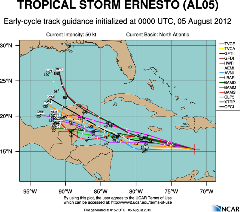
I still say it should strengthen west of Jamaica like most storms do.
Moderator: S2k Moderators
wxman57 wrote:I think the gear shift was into reverse...


You initially described it as "poorly defined"; and I replied that that is/was not that case, and believe that can be objectively determined (i.e., take it out of the realm of opinion into fact) as well by comparison to other storms of similar intensity. Ernesto already had a large outflow canopy at dawn this morning, and it quickly got bigger during the day as 200mb exhausting strongly overrode the area for all but a few hours during the diurnal maxima.hurricanes1234 wrote:Shuriken, if you take a moment and read my comment properly, I said it was slightly less defined in my opinion.

Sanibel wrote:wxman57 wrote:I think the gear shift was into reverse...
Watch the little foot it just grew. If it tails into a band, probably intensification.
I still say it should strengthen west of Jamaica like most storms do.
Shuriken wrote:You initially described it as "poorly defined"; and I replied that that is/was not that case, and believe that can be objectively determined (i.e., take it out of the realm of opinion into fact) as well by comparison to other storms of similar intensity. Ernesto already had a large outflow canopy at dawn this morning, and it quickly got bigger during the day as 200mb exhausting strongly overrode the area for all but a few hours during the diurnal maxima.hurricanes1234 wrote:Shuriken, if you take a moment and read my comment properly, I said it was slightly less defined in my opinion.
Cirrus outriders have now reached eastern Jamaica (and I can faintly see the front of the 200mb clear-air outflow boundary advancing all the way to 80W): http://www.ssd.noaa.gov/goes/east/carb/flash-wv.html


CrazyC83 wrote:I think we might be seeing a center relocation in process right now. Will it relocate under the convection?


Sanibel wrote:Yesterday's bursts could have been delayed strengthening from the Lessers. Today the east Caribbean zone caught up with it as it "skipped" further west waiting for better conditions to continue developing.


Hurricane Allen was a 190mph cat-5 on August 5, 1980 while southeast of Jamaica (ironically that is tomorrow's date, and not far from where Ernesto should be then -- of course Allen had already been a hurricane since the LAs).Sanibel wrote:It's a little early in the season for a buzzsaw


Shuriken wrote:You initially described it as "poorly defined"; and I replied that that is/was not that case, and believe that can be objectively determined (i.e., take it out of the realm of opinion into fact) as well by comparison to other storms of similar intensity. Ernesto already had a large outflow canopy at dawn this morning, and it quickly got bigger during the day as 200mb exhausting strongly overrode the area for all but a few hours during the diurnal maxima.hurricanes1234 wrote:Shuriken, if you take a moment and read my comment properly, I said it was slightly less defined in my opinion.
Cirrus outriders have now reached eastern Jamaica (and I can faintly see the front of the 200mb clear-air outflow boundary advancing all the way to 80W): http://www.ssd.noaa.gov/goes/east/carb/flash-wv.html

Users browsing this forum: No registered users and 169 guests
