Well,a mission has been tasked for Tuesday with plane departing at 9:00 AM EDT.
WEATHER RECONNAISSANCE FLIGHTS
CARCAH, NATIONAL HURRICANE CENTER, MIAMI, FL.
1045 AM EDT MON 13 AUGUST 2012
SUBJECT: TROPICAL CYCLONE PLAN OF THE DAY (TCPOD)
VALID 14/1100Z TO 15/1100Z AUGUST 2012
TCPOD NUMBER.....12-087
I. ATLANTIC REQUIREMENTS
1. REMNANTS OF TROPICAL DEPRESSION SEVEN
FLIGHT ONE --TEAL 72--
A. 14/1700Z
B. AFXXX 0207A INVEST
C. 14/1300Z
D. 15.5N 83.0W
E. 14/1630Z TO 14/1930Z
F. SFC TO 10,000 FT
2. OUTLOOK FOR SUCCEEDING DAY.....NEGATIVE.
ATL: HELENE - Post-Tropical
Moderator: S2k Moderators
-
cycloneye

- Admin

- Posts: 149505
- Age: 69
- Joined: Thu Oct 10, 2002 10:54 am
- Location: San Juan, Puerto Rico
Re: ATL: SEVEN - Recon
0 likes
Visit the Caribbean-Central America Weather Thread where you can find at first post web cams,radars
and observations from Caribbean basin members Click Here
and observations from Caribbean basin members Click Here
-
Portastorm

- Storm2k Moderator

- Posts: 9955
- Age: 63
- Joined: Fri Jul 11, 2003 9:16 am
- Location: Round Rock, TX
- Contact:
Re: ATL: SEVEN - Remnants
It would appear that the possibility exists that the former TD #7 will have an impact on Texas after all! Guess we better watch. NHC tasking a recon flight for tomorrow.
0 likes
Any forecasts under my name are to be taken with a grain of salt. Get your best forecasts from the National Weather Service and National Hurricane Center.
-
Rgv20

- S2K Supporter

- Posts: 2466
- Age: 39
- Joined: Wed Jan 05, 2011 5:42 pm
- Location: Edinburg/McAllen Tx
0 likes
The following post is NOT an official forecast and should not be used as such. It is just the opinion of the poster and may or may not be backed by sound meteorological data. It is NOT endorsed by any professional institution including storm2k.org For Official Information please refer to the NHC and NWS products.
-
floridasun78
- Category 5

- Posts: 3755
- Joined: Sun May 17, 2009 10:16 pm
- Location: miami fl
Re: ATL: SEVEN - Remnants
do you all see this becoming invest? because their planing send plane to ex7
0 likes
-
cycloneye
- Admin
- Posts: 149505
- Age: 69
- Joined: Thu Oct 10, 2002 10:54 am
- Location: San Juan, Puerto Rico
Re: ATL: SEVEN - Remnants
Up to 20%
THE REMNANTS OF TROPICAL DEPRESSION SEVEN ARE MOVING OVER THE
CENTRAL CARIBBEAN SEA AND PRODUCING DISORGANIZED SHOWERS AND
THUNDERSTORMS FROM THE CENTRAL CARIBBEAN NORTHWARD TO HISPANIOLA
AND JAMAICA. UPPER-LEVEL WINDS ARE EXPECTED TO GRADUALLY BECOME
MORE CONDUCIVE FOR REGENERATION OVER THE NEXT DAY OR SO AS THE
SYSTEM MOVES TOWARD HONDURAS...BELIZE...AND THE YUCATAN. THIS
SYSTEM HAS A LOW CHANCE...20 PERCENT...OF BECOMING A TROPICAL
CYCLONE AGAIN DURING THE NEXT 48 HOURS AS IT MOVES WESTWARD NEAR
20 MPH. AN AIR FORCE RESERVE RECONNAISSANCE AIRCRAFT IS SCHEDULED
TO INVESTIGATE THE DISTURBANCE TUESDAY AFTERNOON...IF NECESSARY.
0 likes
Visit the Caribbean-Central America Weather Thread where you can find at first post web cams,radars
and observations from Caribbean basin members Click Here
and observations from Caribbean basin members Click Here
-
ozonepete
- Professional-Met

- Posts: 4743
- Joined: Mon Sep 07, 2009 3:23 pm
- Location: From Ozone Park, NYC / Now in Brooklyn, NY
Re: ATL: SEVEN - Remnants
They put it back up on the floater. Getting interesting again...
http://www.ssd.noaa.gov/PS/TROP/floaters.html
http://www.ssd.noaa.gov/PS/TROP/floaters.html
0 likes
-
wxman57

- Moderator-Pro Met

- Posts: 23175
- Age: 68
- Joined: Sat Jun 21, 2003 8:06 pm
- Location: Houston, TX (southwest)
Re: ATL: SEVEN - Remnants
I don't think we'll see any development in the Caribbean and recon will almost certainly be cancelled tomorrow. Nothing to be concerned about as far as I can see. And I'm a bit doubtful that any significant moisture from the remnants will make it to TX.
0 likes
-
cycloneye
- Admin
- Posts: 149505
- Age: 69
- Joined: Thu Oct 10, 2002 10:54 am
- Location: San Juan, Puerto Rico
Re: ATL: SEVEN - Remnants
18z Best Track
AL, 07, 2012081318, , BEST, 0, 148N, 765W, 30, 1008, WV
ftp://ftp.nhc.noaa.gov/atcf/tcweb/inves ... 012.invest
AL, 07, 2012081318, , BEST, 0, 148N, 765W, 30, 1008, WV
ftp://ftp.nhc.noaa.gov/atcf/tcweb/inves ... 012.invest
0 likes
Visit the Caribbean-Central America Weather Thread where you can find at first post web cams,radars
and observations from Caribbean basin members Click Here
and observations from Caribbean basin members Click Here
-
wxman57
- Moderator-Pro Met
- Posts: 23175
- Age: 68
- Joined: Sat Jun 21, 2003 8:06 pm
- Location: Houston, TX (southwest)
Re: ATL: SEVEN - Remnants
ozonepete wrote:Looks like center has reformed between 15 and 16.
I don't see any evidence of a surface circulation. It's far weaker than it was east of the Caribbean.
0 likes
-
ozonepete
- Professional-Met
- Posts: 4743
- Joined: Mon Sep 07, 2009 3:23 pm
- Location: From Ozone Park, NYC / Now in Brooklyn, NY
Re: ATL: SEVEN - Remnants
wxman57 wrote:ozonepete wrote:Looks like center has reformed between 15 and 16.
I don't see any evidence of a surface circulation. It's far weaker than it was east of the Caribbean.
I should have said reforming; I can't be sure it's closed off since it's under convection but I see a twist to the inflow from west and south sides.
Since it's moving into very low shear zone now and SSTs are so high and little dry air, what are the inhibiting factors that you see wxman?
0 likes
-
wxman57
- Moderator-Pro Met
- Posts: 23175
- Age: 68
- Joined: Sat Jun 21, 2003 8:06 pm
- Location: Houston, TX (southwest)
Re: ATL: SEVEN - Remnants
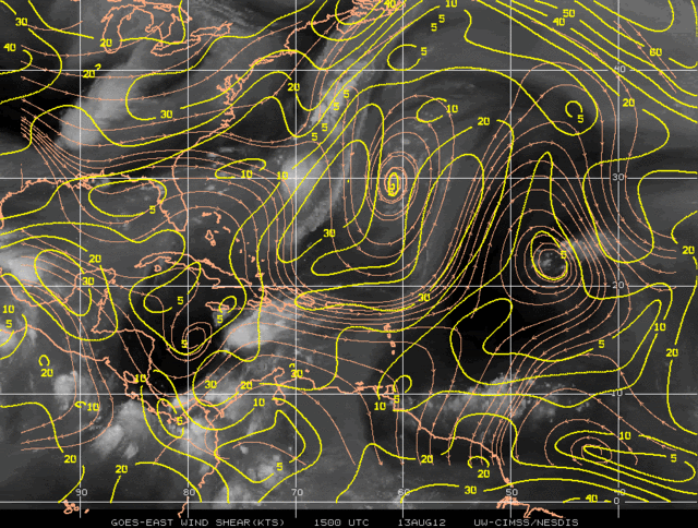
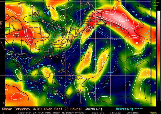
Shear is still quite significant across the disturbance. I don't see any low clouds moving from west to east. I see some east-west oriented low clouds but they seem to be moving along with the easterly trades. Observations indicate ENE flow in advance of the disturbance to the southwest.
0 likes
-
wxman57
- Moderator-Pro Met
- Posts: 23175
- Age: 68
- Joined: Sat Jun 21, 2003 8:06 pm
- Location: Houston, TX (southwest)
Re: ATL: SEVEN - Remnants
I saw the shear graphics. I'm not impressed by what I see on satellite or in surface obs. I calculate a west movement of 20 kts in the past 24 hrs. That would put the wave axis inland into Honduras/Nicaragua by mid day tomorrow.
0 likes
-
ozonepete
- Professional-Met
- Posts: 4743
- Joined: Mon Sep 07, 2009 3:23 pm
- Location: From Ozone Park, NYC / Now in Brooklyn, NY
Re: ATL: SEVEN - Remnants
wxman57 wrote:I saw the shear graphics. I'm not impressed by what I see on satellite or in surface obs.
I'm not that impressed either... yet.
0 likes
-
Portastorm
- Storm2k Moderator
- Posts: 9955
- Age: 63
- Joined: Fri Jul 11, 2003 9:16 am
- Location: Round Rock, TX
- Contact:
Re: ATL: SEVEN - Remnants
wxman57 wrote:I saw the shear graphics. I'm not impressed by what I see on satellite or in surface obs. I calculate a west movement of 20 kts in the past 24 hrs. That would put the wave axis inland into Honduras/Nicaragua by mid day tomorrow.
OK, I've got to ask ... I hear what you're saying and I know you've been honking on the fact that this system won't amount to much if anything ... and it'll move into CA, but why have many Texas NWSFOs been talking about the remnants of this system impacting Texas later this week?
0 likes
Any forecasts under my name are to be taken with a grain of salt. Get your best forecasts from the National Weather Service and National Hurricane Center.
-
wxman57
- Moderator-Pro Met
- Posts: 23175
- Age: 68
- Joined: Sat Jun 21, 2003 8:06 pm
- Location: Houston, TX (southwest)
Re: ATL: SEVEN - Remnants
Portastorm wrote:wxman57 wrote:I saw the shear graphics. I'm not impressed by what I see on satellite or in surface obs. I calculate a west movement of 20 kts in the past 24 hrs. That would put the wave axis inland into Honduras/Nicaragua by mid day tomorrow.
OK, I've got to ask ... I hear what you're saying and I know you've been honking on the fact that this system won't amount to much if anything ... and it'll move into CA, but why have many Texas NWSFOs been talking about the remnants of this system impacting Texas later this week?
Because the GFS had been moving "something" northward from the BoC late this weekend and early next week. The 12Z GFS does it again, but stops the moisture south of Texas in about a week. Question is - will the weak trof across the NW Gulf coast later this week draw any moisture northward from the BoC? None of the weather service offices is saying a TC will move into Texas, just possibly some moisture from the wave.
The other tropical wave (one that we've tracked from Africa) now in the southwestern Gulf looks quite a bit more impressive than Seven, by the way. It's moving slowly northward toward Texas now.
0 likes
-
Shuriken
-
wxman57
- Moderator-Pro Met
- Posts: 23175
- Age: 68
- Joined: Sat Jun 21, 2003 8:06 pm
- Location: Houston, TX (southwest)
Re: ATL: SEVEN - Remnants
Bones says that while not completely dead, Seven is on life support and vital signs are fading.
0 likes
-
hurricanes1234
- Category 5
- Posts: 2908
- Joined: Sat Jul 28, 2012 6:19 pm
- Location: Trinidad and Tobago
Re: ATL: SEVEN - Remnants
The remnants of 7 may be looking pathetic, but 93L holds the real trophy for looking like garbage. 93L's cloudtops are scattered and have not cooled in days. 
0 likes
PLEASE NOTE: With the exception of information from weather agencies that I may copy and paste here, my posts will NEVER be official, since I am NOT a meteorologist. They are solely my amateur opinion, and may or may not be accurate. Therefore, please DO NOT use them as official details, particularly when making important decisions. Thank you.
Who is online
Users browsing this forum: No registered users and 65 guests