ATL: ISAAC - Post-Tropical - Discussion
Moderator: S2k Moderators
-
Stormlover2012
- Category 1

- Posts: 262
- Joined: Sat Jun 23, 2012 11:03 am
-
CYCLONE MIKE
- Category 5

- Posts: 2183
- Joined: Tue Aug 31, 2004 6:04 pm
- Location: Gonzales, LA
Re: ATL: INVEST 94L
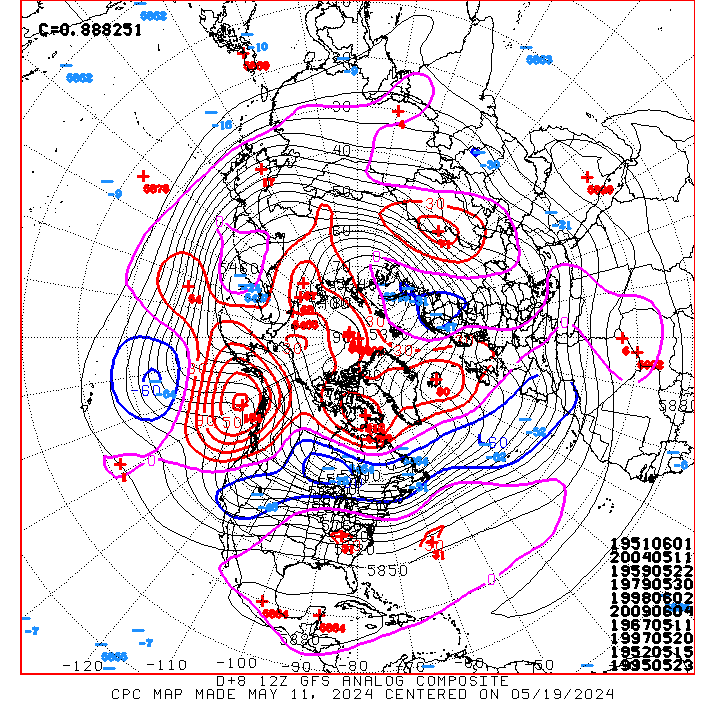
That doesn't mean 94L will follow an analogue, just saying.
Thank you EM. Actually the pattern setup is very similar as to what its been so far this season. This stays weak like all the others and its a caribbean cruiser for quite some time. If by some chance it blows up and deepens a lot more than what models are showing then it could be a fish. But not betting on that.
0 likes
-
christchurchguy
- Tropical Low

- Posts: 43
- Joined: Sat Sep 19, 2009 10:31 am
-
hurricanes1234
- Category 5
- Posts: 2908
- Joined: Sat Jul 28, 2012 6:19 pm
- Location: Trinidad and Tobago
Re: ATL: INVEST 94L
I apologize.....I get hurt very easily. 
0 likes
PLEASE NOTE: With the exception of information from weather agencies that I may copy and paste here, my posts will NEVER be official, since I am NOT a meteorologist. They are solely my amateur opinion, and may or may not be accurate. Therefore, please DO NOT use them as official details, particularly when making important decisions. Thank you.
-
CalmBeforeStorm

- Category 2

- Posts: 600
- Age: 72
- Joined: Tue Aug 10, 2004 7:55 pm
- Location: Stuart, Florida
Re: ATL: INVEST 94L
CYCLONE MIKE wrote:That doesn't mean 94L will follow an analogue, just saying.
Thank you EM. Actually the pattern setup is very similar as to what its been so far this season. This stays weak like all the others and its a caribbean cruiser for quite some time. If by some chance it blows up and deepens a lot more than what models are showing then it could be a fish. But not betting on that.
I don't think it stays weak for as long being that it is later in the season. Therefore I think it's stronger then the models presently show and further right. I see Puerto Rico for now as a likely landing spot. Remember....94L hasn't even reached 40 Longitude yet.
0 likes
-
TropicalAnalystwx13

- Category 5
- Posts: 2109
- Age: 28
- Joined: Tue Jul 19, 2011 8:20 pm
- Location: Wilmington, NC
- Contact:
Re: Re:
FutureEM wrote:TropicalAnalystwx13 wrote:The pattern does not favor a Gulf Coast track. All of the good analogue storms for this invest hit the East Coast or went out to sea between the USA and Bermuda.
That doesn't mean 94L will follow an analogue, just saying.
That may be true, but the pattern does not favor a Gulf coast storm. It favors the East Coast. Go take a look at some of the analogues.
0 likes
-
Hurricane Andrew

- S2K Supporter

- Posts: 1891
- Age: 27
- Joined: Sun May 23, 2010 2:53 pm
- Location: KS

Re:
Hurricane Andrew wrote:Anyone think they may renumber at 11?
IMO, it depends if it can sustain convection. Not much there currently....I do think that it will be named before the islands so all those guys can be on alert.
http://www.ssd.noaa.gov/PS/TROP/floater ... imated.gif
see 2k Disclaimer.....
0 likes
-
Weatherfreak000
-
MGC

- S2K Supporter
- Posts: 5940
- Joined: Sun Mar 23, 2003 9:05 pm
- Location: Pass Christian MS, or what is left.
Re: ATL: INVEST 94L
I doubt 94L gets designated a TD at 11pm. Convection near the center has diminished a bit due to the strong convection to the south of the circulation that may have cut off the moisture feed to the developing low to the north. Once that convection collapses more moisture should be available to sustain convection near the center.....it should take off then......MGC
The above is the opinion of MGC and not an official forecast.
The above is the opinion of MGC and not an official forecast.
0 likes
-
cycloneye
- Admin

- Posts: 149214
- Age: 69
- Joined: Thu Oct 10, 2002 10:54 am
- Location: San Juan, Puerto Rico
Re: ATL: INVEST 94L
MGC wrote:I doubt 94L gets designated a TD at 11pm. Convection near the center has diminished a bit due to the strong convection to the south of the circulation that may have cut off the moisture feed to the developing low to the north. Once that convection collapses more moisture should be available to sustain convection near the center.....it should take off then......MGC
The above is the opinion of MGC and not an official forecast.
Convection will sustain better as it tracks west with the waters warming down the road.

0 likes
Visit the Caribbean-Central America Weather Thread where you can find at first post web cams,radars
and observations from Caribbean basin members Click Here
and observations from Caribbean basin members Click Here
-
tolakram
- Admin
- Posts: 20176
- Age: 62
- Joined: Sun Aug 27, 2006 8:23 pm
- Location: Florence, KY (name is Mark)
Re: ATL: INVEST 94L
latest visible loop

0 likes
M a r k
- - - - -
Join us in chat: Storm2K Chatroom Invite. Android and IOS apps also available.
The posts in this forum are NOT official forecasts and should not be used as such. Posts are NOT endorsed by any professional institution or STORM2K.org. For official information and forecasts, please refer to NHC and NWS products.
Re:
Hurricane Andrew wrote:Anyone think they may renumber at 11?
I highly doubt it. It needs more convection, and I personally don't foresee it happening. Even if there's a big blow up of convection, it'd have to be sustained for it to become a TD. I think the soonest the system could be classified is sometime, mid day tomorrow.
0 likes
I'm no expert, everything I say should be taken with a large amount of salt. I could easily be very, very wrong.
~Zanthe Go Coyotes~
~Zanthe Go Coyotes~
-
Hurricane Alexis

- Category 2
- Posts: 683
- Age: 29
- Joined: Thu Jun 14, 2012 7:59 pm
- Location: Miami,Florida
Re: Re:
TropicalAnalystwx13 wrote:FutureEM wrote:TropicalAnalystwx13 wrote:The pattern does not favor a Gulf Coast track. All of the good analogue storms for this invest hit the East Coast or went out to sea between the USA and Bermuda.
That doesn't mean 94L will follow an analogue, just saying.
That may be true, but the pattern does not favor a Gulf coast storm. It favors the East Coast. Go take a look at some of the analogues.
When you say east coast you also mean florida?
0 likes
Personal Forecast Disclaimer:
The posts in this forum are NOT official forecast and should not be used as such. They are just the opinion of the poster and may or may not be backed by sound meteorological data. They are NOT endorsed by any professional institution or storm2k.org. For official information, please refer to the NHC and NWS products.
The posts in this forum are NOT official forecast and should not be used as such. They are just the opinion of the poster and may or may not be backed by sound meteorological data. They are NOT endorsed by any professional institution or storm2k.org. For official information, please refer to the NHC and NWS products.
-
Hurricaneman

- Category 5
- Posts: 7404
- Age: 45
- Joined: Tue Aug 31, 2004 3:24 pm
- Location: central florida
Re: ATL: INVEST 94L
Is it me or is this going south of due west at the moment
Personal Forecast Disclaimer:
The posts in this forum are NOT official forecast and should not be used as such. They are just the opinion of the poster and may or may not be backed by sound meteorological data. They are NOT endorsed by any professional institution or storm2k.org. For official information, please refer to the NHC and NWS products.
0 likes
-
tolakram
- Admin
- Posts: 20176
- Age: 62
- Joined: Sun Aug 27, 2006 8:23 pm
- Location: Florence, KY (name is Mark)
Re: ATL: INVEST 94L
Hurricaneman wrote:
Is it me or is this going south of due west at the moment
Personal Forecast Disclaimer:
The posts in this forum are NOT official forecast and should not be used as such. They are just the opinion of the poster and may or may not be backed by sound meteorological data. They are NOT endorsed by any professional institution or storm2k.org. For official information, please refer to the NHC and NWS products.
It appears that the mid level circulation moved SW, but I'm not sure if this is from shear blowing it off, or the LLC, such that it is, drifting south.
0 likes
M a r k
- - - - -
Join us in chat: Storm2K Chatroom Invite. Android and IOS apps also available.
The posts in this forum are NOT official forecasts and should not be used as such. Posts are NOT endorsed by any professional institution or STORM2K.org. For official information and forecasts, please refer to NHC and NWS products.
- - - - -
Join us in chat: Storm2K Chatroom Invite. Android and IOS apps also available.
The posts in this forum are NOT official forecasts and should not be used as such. Posts are NOT endorsed by any professional institution or STORM2K.org. For official information and forecasts, please refer to NHC and NWS products.
-
cycloneye
- Admin
- Posts: 149214
- Age: 69
- Joined: Thu Oct 10, 2002 10:54 am
- Location: San Juan, Puerto Rico
Re: ATL: INVEST 94L
This is the preliminary thinking by NHC about where the system may be in 72 hours.

0 likes
Visit the Caribbean-Central America Weather Thread where you can find at first post web cams,radars
and observations from Caribbean basin members Click Here
and observations from Caribbean basin members Click Here
-
BatzVI

- Tropical Storm

- Posts: 199
- Joined: Sat Jun 10, 2006 8:27 am
- Location: St. Thomas, Virgin Islands
Re: ATL: INVEST 94L
At this point, how safe is it to say that this will stay south of the USVI/PR area? Seems it is staying on a westerly course. Does anyone see anything that could possibly bring this system more north?
0 likes
-
gatorcane

- S2K Supporter
- Posts: 23708
- Age: 48
- Joined: Sun Mar 13, 2005 3:54 pm
- Location: Boca Raton, FL
The posts in this forum are NOT official forecast and should not be used as such. They are just the opinion of the poster and may or may not be backed by sound meteorological data. They are NOT endorsed by any professional institution or storm2k.org. For official information, please refer to the NHC and NWS products.
A fairly brisk westward track through the Central/Northern Leewards through the Caribbean to around the longitude of Hispaniola/Jamaica area looks likely where the system should remain around tropical storm status due to the presence of SAL and the brisk forward speed. Then it does look like a weakness will exist over the Bahamas/Florida/GOM by this time next week as the Western Atlantic ridge weakens some and retreats to the east. This weakness looks more pronounced than when Ernesto and ex-TD7 moved through prior. A weak system would continue heading more WNW but slower towards the Northern Yucatan...a stronger system should respond to the weakness and move slowly NW or even North. I am leaning towards the latter scenario at this time looking at the latest GFS 18Z 500MB steering, the latest GFS ensemble guidance, and the trough that the 12Z ECMWF shows over Eastern North America by early next week. I also expect conditions to be more favorable for intensification once the system nears the longitude of Jamaica in the Western Caribbean that will allow the system to deepen enough to respond the weakness.
Last edited by gatorcane on Sun Aug 19, 2012 6:37 pm, edited 4 times in total.
0 likes
-
tolakram
- Admin
- Posts: 20176
- Age: 62
- Joined: Sun Aug 27, 2006 8:23 pm
- Location: Florence, KY (name is Mark)
Re: ATL: INVEST 94L
BatzVI wrote:At this point, how safe is it to say that this will stay south of the USVI/PR area? Seems it is staying on a westerly course. Does anyone see anything that could possibly bring this system more north?
I would say too early to tell, and way too close to be sure of anything. If I lived in the islands I would be finalizing any preparations not already made. Better to be safe than sorry. This could be anything from a thundershower passing by to a Hurricane, just too early to tell at the moment.
Personal Forecast Disclaimer:
The posts in this forum are NOT official forecast and should not be used as such. They are just the opinion of the poster and may or may not be backed by sound meteorological data. They are NOT endorsed by any professional institution or storm2k.org. For official information, please refer to the NHC and NWS products.
0 likes
M a r k
- - - - -
Join us in chat: Storm2K Chatroom Invite. Android and IOS apps also available.
The posts in this forum are NOT official forecasts and should not be used as such. Posts are NOT endorsed by any professional institution or STORM2K.org. For official information and forecasts, please refer to NHC and NWS products.
- - - - -
Join us in chat: Storm2K Chatroom Invite. Android and IOS apps also available.
The posts in this forum are NOT official forecasts and should not be used as such. Posts are NOT endorsed by any professional institution or STORM2K.org. For official information and forecasts, please refer to NHC and NWS products.
Who is online
Users browsing this forum: No registered users and 20 guests