ATL: ISAAC - Post-Tropical - Discussion
Moderator: S2k Moderators
-
SouthFloridawx

- S2K Supporter

- Posts: 8346
- Age: 47
- Joined: Tue Jul 26, 2005 1:16 am
- Location: Sarasota, FL
- Contact:
Re: ATL: ISAAC - Tropical Storm - Discussion
Last edited by tolakram on Wed Aug 22, 2012 10:25 pm, edited 1 time in total.
Reason: removed direct embed of image
Reason: removed direct embed of image
0 likes
-
CYCLONE MIKE
- Category 5

- Posts: 2183
- Joined: Tue Aug 31, 2004 6:04 pm
- Location: Gonzales, LA
Re: ATL: ISAAC - Tropical Storm - Discussion
Concerning the 11pm forecast, I would be very surprised to see him become a hurricane so quick again after crossing Haiti and most of eastern Cuba.
0 likes
-
Ivanhater

- Storm2k Moderator

- Posts: 11221
- Age: 39
- Joined: Fri Jul 01, 2005 8:25 am
- Location: Pensacola
Re: ATL: ISAAC - Tropical Storm - Discussion
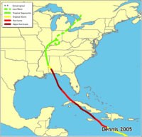
Based on current modeling...Hurricane Dennis and Frederick come to mind. Both crossed the mountains and blew back up in the Gulf.
0 likes
Michael
-
Ikester
- Professional-Met

- Posts: 361
- Age: 40
- Joined: Mon Jun 21, 2010 5:00 pm
- Location: Jacksonville, FL
Here's an interesting tidbit that means nothing: ''C'' storms and ''I'' storms are tied for first place with the amount of names retired due to destruction/deaths in the United States. It's a bit disconcerting that some of the models bomb out Isaac in the eastern gulf. A landfalling hurricane of any category, even a 1, near Apalachicola would drive huge surge into the big bend of Florida.
Last edited by Ikester on Wed Aug 22, 2012 10:23 pm, edited 1 time in total.
0 likes

Re: ATL: ISAAC - Tropical Storm - Discussion
Is it safe to say at this point that the northern coast of Texas is in the clear, or is it still too early to make that call?
0 likes
Any forecast I make is based on my opinion only. Please refer to the NWS or NHC for official forecasts.
-
ozonepete
- Professional-Met
- Posts: 4743
- Joined: Mon Sep 07, 2009 3:23 pm
- Location: From Ozone Park, NYC / Now in Brooklyn, NY
Re: ATL: ISAAC - Tropical Storm - Discussion
Looks like it's really consolidating now. Pretty impressive compared to just a few hours ago...


0 likes
-
jasons2k

- Storm2k Executive

- Posts: 8290
- Age: 52
- Joined: Wed Jul 06, 2005 12:32 pm
- Location: The Woodlands, TX
Re: ATL: ISAAC - Tropical Storm - Discussion
Ivanhater wrote:Based on current modeling...Hurricane Dennis and Frederick come to mind. Both crossed the mountains and blew back up in the Gulf.
I think anything from Dennis to GLS 1900 is on the table. This morning I thought a Frederick-like path was a great analogue. Tonight, I'm not so sure.
0 likes
-
WeatherGuesser
- Category 5
- Posts: 2672
- Joined: Tue Jun 29, 2010 6:46 am

-
jasons2k
- Storm2k Executive
- Posts: 8290
- Age: 52
- Joined: Wed Jul 06, 2005 12:32 pm
- Location: The Woodlands, TX
Re: ATL: ISAAC - Tropical Storm - Discussion
Snowman67 wrote:Is it safe to say at this point that the northern coast of Texas is in the clear, or is it still too early to make that call?
The Upper TX Coast is certainly not in the clear yet.
0 likes

Re: ATL: ISAAC - Tropical Storm - Discussion
jasons wrote:cycloneye wrote:It is already showing up at the San Juan long range radar.Look way down.
I just want to remind people from this distance that is the MLC depicted on radar, which is displaced from the surface circulation. Isaac is still very tilted per the recon obs.
Also, I'm getting more concerned with the possibility of very weak steering currents next week and the ridge possibly rebuilding over the SE US. We still have a long ways to go before we have any confidence on where Isaac will end-up.
there is talk of that very same scenario around the web....watching closely...
0 likes
-
ozonepete
- Professional-Met
- Posts: 4743
- Joined: Mon Sep 07, 2009 3:23 pm
- Location: From Ozone Park, NYC / Now in Brooklyn, NY
Re: ATL: ISAAC - Tropical Storm - Discussion
Snowman67 wrote:Is it safe to say at this point that the northern coast of Texas is in the clear, or is it still too early to make that call?
Still too early. But the model consensus has it recurving somewhere over Florida. You will just have to wait a day or two to be more certain.
Last edited by ozonepete on Wed Aug 22, 2012 10:26 pm, edited 1 time in total.
0 likes
-
Shuriken
-
jasons2k
- Storm2k Executive
- Posts: 8290
- Age: 52
- Joined: Wed Jul 06, 2005 12:32 pm
- Location: The Woodlands, TX
Re:
WeatherGuesser wrote:If this thing keeps coming west, I'll be wondering about an Ike-like path.
Thoughts on anything in the plains states that might turn it if it were to get as far west as TX/LA?
If it misses the trough, there won't be anything left to pull it north. A distinct possibility is for steering currents to collapse, the ridge builds back, and this gets pushed towards the west.
The fact that some of the globals are stalling this at the end is troubling. Also, the ensembles are spreading rather than clustering; this is not a trend we want to see.
0 likes

Re: ATL: ISAAC - Tropical Storm - Discussion
i have been staring at this Rainbow color loop all night and I can honestly say I have never been as perplexed at a storm as I am tonight...no idea what is going on here, looks like it may be reorganizing down to the SE but I am confused as heck
http://www.ssd.noaa.gov/PS/TROP/floaters/09L/flash-rb-long.html
http://www.ssd.noaa.gov/PS/TROP/floaters/09L/flash-rb-long.html
0 likes
Just like Jon Snow..."I know nothing" except what I know, and most of what I know is gathered by the fine people of the NHC
-
lrak

- S2K Supporter
- Posts: 1770
- Age: 59
- Joined: Thu Jun 21, 2007 2:48 pm
- Location: Corpus Christi, TX
Re:
Shuriken wrote:On Lesser Antilles radar, it looks like the mid-level circulation from last night's blow-up has re-asserted itself, and the tonight's blob has arced around into it.
The satallite loop makes it look like the bottom vortex won the battle.
0 likes
AKA karl
Also
Personal Forecast Disclaimer:
My posts on this forum are NOT official forecast and should not be used as such. My posts are my basic observations and are definitely not backed by any "well some" meteorological knowledge. For official information, please refer to the NHC and NWS products.
Also
Personal Forecast Disclaimer:
My posts on this forum are NOT official forecast and should not be used as such. My posts are my basic observations and are definitely not backed by any "well some" meteorological knowledge. For official information, please refer to the NHC and NWS products.
-
BigB0882
- S2K Supporter
- Posts: 2291
- Joined: Thu Jul 03, 2003 12:08 am
- Location: Baton Rouge, LA
- Contact:
It certainly looks like the main blob of convection is circling around something. The actual center? It is easy to see that blob and pin the center in the middle of it but I don't think that is the case here. That's why people keep saying the center is all over the place. Some claim is moved to the N, some say the S. I think it depends when they look at the images and where the blob is at the time.
0 likes
Re: Re:
lrak wrote:Shuriken wrote:On Lesser Antilles radar, it looks like the mid-level circulation from last night's blow-up has re-asserted itself, and the tonight's blob has arced around into it.
The satallite loop makes it look like the bottom vortex won the battle.
yeah maybe....I think RECON left...so we will have to wait until the next mission.
0 likes
-
Ivanhater
- Storm2k Moderator
- Posts: 11221
- Age: 39
- Joined: Fri Jul 01, 2005 8:25 am
- Location: Pensacola
Re: ATL: ISAAC - Tropical Storm - Discussion
jasons wrote:Ivanhater wrote:Based on current modeling...Hurricane Dennis and Frederick come to mind. Both crossed the mountains and blew back up in the Gulf.
I think anything from Dennis to GLS 1900 is on the table. This morning I thought a Frederick-like path was a great analogue. Tonight, I'm not so sure.
Based on current model consensus guidance, Dennis looks very good right now..plenty of time for that to change, but as of now I like that analog
0 likes
Michael
-
bamajammer4eva
- Category 4

- Posts: 907
- Joined: Sun Apr 18, 2010 3:21 am
- Location: Ozark, AL
Re:
WeatherGuesser wrote:If this thing keeps coming west, I'll be wondering about an Ike-like path.
Thoughts on anything in the plains states that might turn it if it were to get as far west as TX/LA?
This is the answer to that from a meteorologist on the models thread
viewtopic.php?f=59&t=113367&st=0&sk=t&sd=a&start=1860
Come on peeps, please quit comparing this storm to Ike. The set up is totally different now than it was in September 2008. For Ike, the ridge was centered just north of Florida and was weakening. The trough that picked Ike up came in from the Dakotas. The setup now is a persistent trough over the eastern Conus between the ridge to the west over Texas and the Bermuda high. This is not a Texas threat IMO. Notice on the maps below, the highs and lows are reversed.
0 likes
Who is online
Users browsing this forum: No registered users and 14 guests