Texas Summer 2012
Moderator: S2k Moderators
Forum rules

The posts in this forum are NOT official forecast and should not be used as such. They are just the opinion of the poster and may or may not be backed by sound meteorological data. They are NOT endorsed by any professional institution or STORM2K.
-
Portastorm

- Storm2k Moderator

- Posts: 9955
- Age: 63
- Joined: Fri Jul 11, 2003 9:16 am
- Location: Round Rock, TX
- Contact:
Re: Texas Summer 2012
Unfortunately the concerns I shared yesterday appear to be coming to fruition. Assuming Isaac behaves as progged by the NHC, we here in south central Texas will be in for a lot of hot-and-dry later next week. 
0 likes
Any forecasts under my name are to be taken with a grain of salt. Get your best forecasts from the National Weather Service and National Hurricane Center.
-
Rgv20

- S2K Supporter

- Posts: 2466
- Age: 39
- Joined: Wed Jan 05, 2011 5:42 pm
- Location: Edinburg/McAllen Tx

"LONG TERM /SATURDAY NIGHT THROUGH THURSDAY/...MIDLEVEL TROUGH
MOVING THROUGH THE CENTRAL PLAINS WILL BE WEAKENING AND EJECTING
AT THE BEGINNING OF THE PERIOD...WHILE WESTERN RIDGE CONTINUES TO
DOMINATE. FOR THE MOST PART...SUBSIDENCE WITH THE RIDGE WILL
CONTINUE TO HOLD DOWN THE SEABREEZE...WITH MINIMAL CHANCES FOR ANY
POP-UP SHOWERS SUNDAY AND MONDAY. TUESDAY...MODELS ARE SHOWING A
SURGE OF DRIER AIR FROM THE NORTH...ASSOCIATED WITH NORTHERLY FLOW
WRAPPING AROUND ISAAC. THIS WOULD HAVE THE EFFECT OF COMPLETELY
ENDING POP CHANCES AND DRIVING TEMPERATURES UPWARD A COUPLE MORE
DEGREES TUESDAY THROUGH THURSDAY. MODELS ARE GETTING IN BETTER
AGREEMENT HERE...SO HAVE GONE AHEAD AND LOWERED POP CHANCES FOR
MIDWEEK AND PUSHED TEMPS UP A COUPLE DEGREES...WAITING ON THE
FINAL TRACKING FOR ISAAC BEFORE INCREASING TEMPS ANY FURTHER."
0 likes
The following post is NOT an official forecast and should not be used as such. It is just the opinion of the poster and may or may not be backed by sound meteorological data. It is NOT endorsed by any professional institution including storm2k.org For Official Information please refer to the NHC and NWS products.

Yeah recent models don't look as good. I still stand by the slim chance it gets caught underneath a high though! 
Side note there's a shortwave coming through today and depending on strong it is maybe some of us can see some measurable rain. Most likely west of I-35 in both DFW and Austin.
Side note there's a shortwave coming through today and depending on strong it is maybe some of us can see some measurable rain. Most likely west of I-35 in both DFW and Austin.
0 likes
The above post and any post by Ntxw is NOT an official forecast and should not be used as such. It is just the opinion of the poster and may or may not be backed by sound meteorological data. It is NOT endorsed by any professional institution including Storm2k. For official information, please refer to NWS products.
Help support Storm2K!
-
weatherdude1108
- Category 5

- Posts: 4228
- Joined: Tue Dec 13, 2011 1:04 pm
- Location: Northwest Austin/Cedar Park, TX
But, the high in Austin on Labor Day 2011 was 102 degrees. The high this Labor Day is only supposed to be a BRISK 98 degrees!
August 2011 Camp Mabry
http://www.nws.noaa.gov/climate/getclimate.php?wfo=ewx
Sept. 2011 Camp Mabry
http://www.nws.noaa.gov/climate/getclimate.php?wfo=ewx
0 likes
The preceding post is NOT an official forecast, and should not be used as such. It is only the opinion of the poster and may or may not be backed by sound meteorological data. It is NOT endorsed by any professional institution including storm2k.org. For Official Information please refer to the NHC and NWS products.
Well the PNA is very positive now and the hot forecast by some models (at least northern half of state) looks less likely. On and off bouts of rain with shortwaves coming through every few days and Isaac will likely bring northeasterly flow as mentioned by FW. This will give us lots of dry air so seasonal (comfortable) high temps low to mid 90s and lows below average in the 60s next week! This scenario a year ago would've brought fires but thanks to the rains not the case this year.
Unfortunately those in the southern half of the state continues to bake.
Unfortunately those in the southern half of the state continues to bake.
0 likes
The above post and any post by Ntxw is NOT an official forecast and should not be used as such. It is just the opinion of the poster and may or may not be backed by sound meteorological data. It is NOT endorsed by any professional institution including Storm2k. For official information, please refer to NWS products.
Help support Storm2K!
Help support Storm2K!
-
somethingfunny

- ChatStaff

- Posts: 3926
- Age: 37
- Joined: Thu May 31, 2007 10:30 pm
- Location: McKinney, Texas
Re: Texas Summer 2012
Just when you thought there was tight model consensus....the 8/26 00z GFS....


0 likes
I am not a meteorologist, and any posts made by me are not official forecasts or to be interpreted as being intelligent. These posts are just my opinions and are probably silly opinions.
-
Rgv20
- S2K Supporter
- Posts: 2466
- Age: 39
- Joined: Wed Jan 05, 2011 5:42 pm
- Location: Edinburg/McAllen Tx
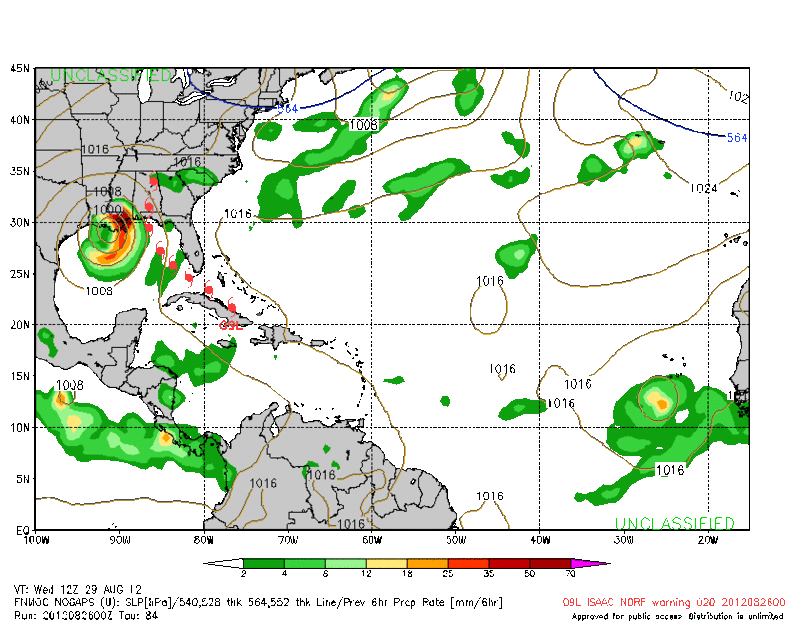
0zCMC +84hrs
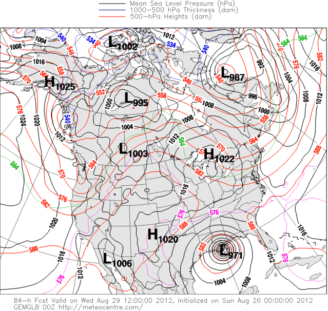
0zNOGAPS +84hrs
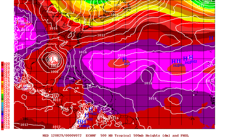
However the reliable ECMWF still calls for a Western Florida Panhandle Landfall.
0zECMWF 72+hrs
0 likes
The following post is NOT an official forecast and should not be used as such. It is just the opinion of the poster and may or may not be backed by sound meteorological data. It is NOT endorsed by any professional institution including storm2k.org For Official Information please refer to the NHC and NWS products.
-
aggiecutter
- Category 5
- Posts: 1755
- Joined: Thu Oct 14, 2004 9:22 pm
- Location: Texarkana
Re: Texas Summer 2012
12Z GFS send the remnants of Isaac right through the Texarkana area, with copious amounts of rain.
http://mag.ncep.noaa.gov/NCOMAGWEB/appc ... mageSize=M
http://mag.ncep.noaa.gov/NCOMAGWEB/appc ... mageSize=M
0 likes

Wherever Isaac ends up it looks like central Tx will be on the west side of it and as Portastorm pointed out that just leaves us hot and dry, but I did have a morning shower that left us with 3/10 of an inch of rain and I am grateful for any amounts right now.
Now back to the tropical threads to follow Isaac like everyone else.
Now back to the tropical threads to follow Isaac like everyone else.
0 likes
Any opinions stated are those of an amateur, please take with several grains of salt and for official forecast refer to the National Weather Service.
-
Rgv20
- S2K Supporter
- Posts: 2466
- Age: 39
- Joined: Wed Jan 05, 2011 5:42 pm
- Location: Edinburg/McAllen Tx
Special Weather Statement
SPECIAL WEATHER STATEMENT...CORRECTED
NATIONAL WEATHER SERVICE BROWNSVILLE TX
939 AM CDT MON AUG 27 2012
TXZ251-253>257-271700-
KENEDY-HIDALGO-INLAND WILLACY-INLAND CAMERON-COASTAL WILLACY-
COASTAL CAMERON-
INCLUDING THE CITIES OF...SARITA...MCALLEN...EDINBURG...PHARR...
MISSION...WESLACO...RAYMONDVILLE...BROWNSVILLE...HARLINGEN...
PORT MANSFIELD...PORT ISABEL...SOUTH PADRE ISLAND...
LAGUNA HEIGHTS...LAGUNA VISTA
939 AM CDT MON AUG 27 2012
...MINOR IMPACTS FROM TROPICAL STORM ISAAC EXPECTED...
TROPICAL STORM ISAAC CONTINUES TO MOVE TOWARDS THE SOUTHEAST
LOUISIANA COASTLINE. CURRENT PROJECTIONS TAKE THIS STORM TO NEW
ORLEANS LATE TUESDAY NIGHT OR VERY EARLY WEDNESDAY MORNING AS A
CATEGORY ONE HURRICANE.
THE EXPECTED TRACK AND INTENSITY OF ISAAC WILL HAVE AN IMMEDIATE
IMPACT ON THE LOWER TEXAS COASTAL WATERS AND AREA BEACHES STARTING
TODAY AND CONTINUING THROUGH WEDNESDAY NIGHT. SWELLS GENERATED BY
THE STORM WILL BE DIRECTED WEST TOWARDS THE TEXAS COAST. THE FIRST
IMPACT TO BE FELT WILL BE THE INCREASED RISK OF RIP CURRENTS. AS
THE LONG PERIOD SWELLS APPROACH OUR COAST TODAY...A HIGH RISK OF
RIP CURRENTS IS LIKELY. PLEASE REFER TO THE LATEST RIP CURRENT
STATEMENT FOR MORE INFORMATION.
TUESDAY AND WEDNESDAY WILL CONTINUE TO SEE THE IMPACTS INCREASE AS
THE LARGE SWELL CONTINUES TO BE DIRECTED TOWARDS THE BEACHES OF
SOUTH PADRE ISLAND AND BOCA CHICA BEACH. MINOR COASTAL FLOODING IS
POSSIBLE AS BREAKING WAVES RUN UP TO THE BASE OF THE SAND DUNES.
THIS WILL CAUSE MINOR INCONVENIENCES FOR DRIVING ALONG THE BEACH...
AS WELL AS TO BEACH GOERS AND ANYONE FISHING ALONG THE SOUTH PADRE
ISLAND JETTY. ASTRONOMICAL HIGH TIDE IS EXPECTED AROUND 4 AM CDT
BOTH TUESDAY AND WEDNEDAY MORNING WITH PROJECTED TIDES RUNNING
AROUND 1.7 FEET ABOVE NORMAL. THIS WILL PRODUCE THE WORST FLOODING
POTENTIAL LATE TUESDAY NIGHT THROUGH WEDNESDAY.
FINALLY...COMMERCIAL AND RECREATIONAL MARINERS CAN EXPECT OPEN
OCEAN SWELLS TO INCREASE TO BETWEEN 5 AND 7 FEET TUESDAY NIGHT
THROUGH WEDNESDAY OVER THE LOWER TEXAS COASTAL WATERS WITH SWELL
PERIODS INCREASING TO 12 TO 14 SECONDS AT THAT TIME. PLEASE REFER
TO THE MARINE WEATHER STATEMENT FOR ADDITIONAL INFORMATION.
STAY TUNED TO NOAA WEATHER RADIO OR YOUR LOCAL MEDIA FOR FURTHER
UPDATES.
&&
FOR ALL YOUR LOCAL WEATHER NEEDS...GO TO OUR WEBSITE AT
HTTP://WEATHER.GOV/RGV.
0 likes
The following post is NOT an official forecast and should not be used as such. It is just the opinion of the poster and may or may not be backed by sound meteorological data. It is NOT endorsed by any professional institution including storm2k.org For Official Information please refer to the NHC and NWS products.
-
Rgv20
- S2K Supporter
- Posts: 2466
- Age: 39
- Joined: Wed Jan 05, 2011 5:42 pm
- Location: Edinburg/McAllen Tx
NWS Brownsville morning discussion...Hopefully we can enter September with some rain. (Climatology speaking September is the rainiest month for my area  )
)
"FRIDAY LOOKS LIKE A TRANSITION DAY AS ISSAC FINALLY MOVES OUT OF
THE PICTURE AND SOUTH WINDS RETURN. TEMPERATURES REMAIN HOT BUT
LOOKS TO DROP A FEW DEGREES AS THE DEW POINTS INCREASE. DEEPER
MOISTURE MOVES INTO THE REGION ON THE HEELS OF A TROPICAL WAVE
SATURDAY WITH THE CHANCE OF RAIN ENTERING THE FORECAST SATURDAY
AND SUNDAY ALBEIT LOW. TEMPERATURES TO RETURN TO SEASONAL VALUES
WITH NEAR 90 AT THE COAST TO AROUND 100 INLAND WEST."
0 likes
The following post is NOT an official forecast and should not be used as such. It is just the opinion of the poster and may or may not be backed by sound meteorological data. It is NOT endorsed by any professional institution including storm2k.org For Official Information please refer to the NHC and NWS products.
-
weatherdude1108
- Category 5
- Posts: 4228
- Joined: Tue Dec 13, 2011 1:04 pm
- Location: Northwest Austin/Cedar Park, TX
Been observing convection scooting south most of the day. Also observing the proverbial black hole around Austin as the convection evaporates from the north, moving around to the west and east. Was hoping to get a nice soaking on the vegetation around here before the blast furnace side of Isaac sets in. 
0 likes
-
Portastorm
- Storm2k Moderator
- Posts: 9955
- Age: 63
- Joined: Fri Jul 11, 2003 9:16 am
- Location: Round Rock, TX
- Contact:
Re:
weatherdude1108 wrote:Been observing convection scooting south most of the day. Also observing the proverbial black hole around Austin as the convection evaporates from the north, moving around to the west and east. Was hoping to get a nice soaking on the vegetation around here before the blast furnace side of Isaac sets in.
Sad isn't it?! I also saw those cumulonimbus way to our north and west ... while we roast. And Isaac will just make it worse later this week. Sometimes though a hurricane this time of year can help usher in a pattern change in the CONUS. Maybe Isaac can prompt a faster evolution of the westerlies taking command ... thus more fronts ... cooler temps, precip chances, etc.
Hey, a fella can dream can't he?!
0 likes
Any forecasts under my name are to be taken with a grain of salt. Get your best forecasts from the National Weather Service and National Hurricane Center.
-
weatherdude1108
- Category 5
- Posts: 4228
- Joined: Tue Dec 13, 2011 1:04 pm
- Location: Northwest Austin/Cedar Park, TX
Re: Re:
Portastorm wrote:weatherdude1108 wrote:Been observing convection scooting south most of the day. Also observing the proverbial black hole around Austin as the convection evaporates from the north, moving around to the west and east. Was hoping to get a nice soaking on the vegetation around here before the blast furnace side of Isaac sets in.
Sad isn't it?! I also saw those cumulonimbus way to our north and west ... while we roast. And Isaac will just make it worse later this week. Sometimes though a hurricane this time of year can help usher in a pattern change in the CONUS. Maybe Isaac can prompt a faster evolution of the westerlies taking command ... thus more fronts ... cooler temps, precip chances, etc.
Hey, a fella can dream can't he?!
That's encouraging! Cool.
Yep! I've been doing a lot of dreaming of wet and green places!
0 likes
Not to rain on the parade, but unfortunately the forecast for the PNA is for it to go negative. If we are on the bad side of Isaac the two tandems could bring heat (yuck) come first week of Sept. Euro doesn't look pretty. At least our days are getting shorter
0 likes
The above post and any post by Ntxw is NOT an official forecast and should not be used as such. It is just the opinion of the poster and may or may not be backed by sound meteorological data. It is NOT endorsed by any professional institution including Storm2k. For official information, please refer to NWS products.
Help support Storm2K!
Help support Storm2K!
-
Rgv20
- S2K Supporter
- Posts: 2466
- Age: 39
- Joined: Wed Jan 05, 2011 5:42 pm
- Location: Edinburg/McAllen Tx
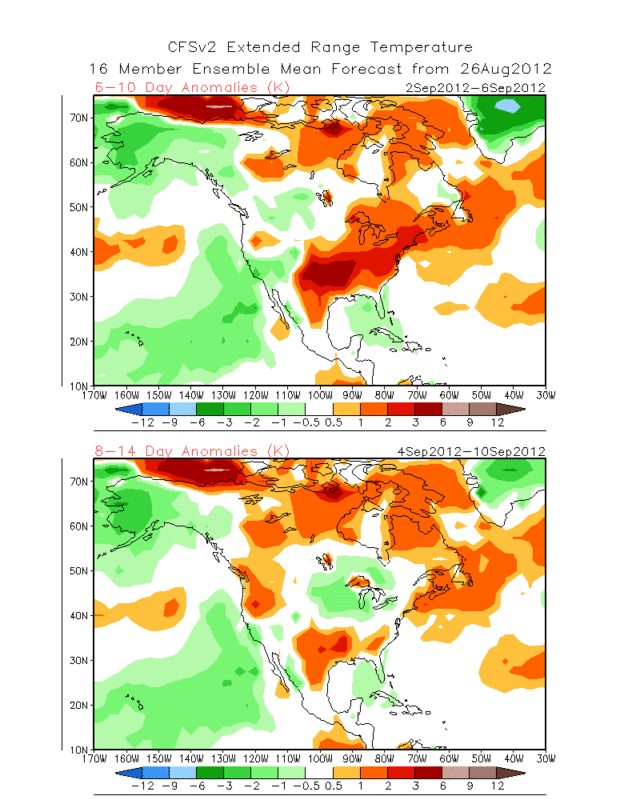
Look at the forecast of above normal temperature from the CFSv2 starting September.....Looks like you are right Ntxw, more warm weather in store for most of Texas.
0 likes
The following post is NOT an official forecast and should not be used as such. It is just the opinion of the poster and may or may not be backed by sound meteorological data. It is NOT endorsed by any professional institution including storm2k.org For Official Information please refer to the NHC and NWS products.
-
South Texas Storms

- Professional-Met

- Posts: 4259
- Joined: Thu Jun 24, 2010 12:28 am
- Location: Houston, TX
Re: Texas Summer 2012
Ntxw, what are your latest thoughts on the Nino event and our long range forecast? Do you still expect a moderate Nino this winter (and lots of cut-off lows bringing us cooler and wet weather)?
0 likes
Re: Texas Summer 2012
South Texas Storms wrote:Ntxw, what are your latest thoughts on the Nino event and our long range forecast? Do you still expect a moderate Nino this winter (and lots of cut-off lows bringing us cooler and wet weather)?
No change, I do think a low end moderate Nino is very possible. At the very least a strong-weak Nino. A moderate Nino will probably give less in the way of cold air but more storms and prolonged cool while a weak nino a bit less storms and slightly colder on the cool. SOI has been puzzling me but at least the Nino has not been reflecting it which shows it has pretty good footing right now.
How fast the changes comes will depend on how quickly the 3.4 anomalies rise the coming weeks. Baja continues to warm so look there for cut off lows come fall. Euro seasonal forecast for August paints a wet picture for the state during the fall/early winter especially central and southern Texas.
0 likes
The above post and any post by Ntxw is NOT an official forecast and should not be used as such. It is just the opinion of the poster and may or may not be backed by sound meteorological data. It is NOT endorsed by any professional institution including Storm2k. For official information, please refer to NWS products.
Help support Storm2K!
Help support Storm2K!
-
South Texas Storms
- Professional-Met
- Posts: 4259
- Joined: Thu Jun 24, 2010 12:28 am
- Location: Houston, TX
Re: Texas Summer 2012
Ntxw wrote:South Texas Storms wrote:Ntxw, what are your latest thoughts on the Nino event and our long range forecast? Do you still expect a moderate Nino this winter (and lots of cut-off lows bringing us cooler and wet weather)?
No change, I do think a low end moderate Nino is very possible. At the very least a strong-weak Nino. A moderate Nino will probably give less in the way of cold air but more storms and prolonged cool while a weak nino a bit less storms and slightly colder on the cool. SOI has been puzzling me but at least the Nino has not been reflecting it which shows it has pretty good footing right now.
How fast the changes comes will depend on how quickly the 3.4 anomalies rise the coming weeks. Baja continues to warm so look there for cut off lows come fall. Euro seasonal forecast for August paints a wet picture for the state during the fall/early winter especially central and southern Texas.
Thanks Ntxw, I appreciate your ENSO analysis! I'm thinking we will have at least one decent chance at winter precip. across central Texas this winter. I can't wait for the cut-off low parade to begin!
The SOI has been puzzling to me too lately. Where does the MJO need to be for it to raise SST anomalies in region 3.4? Does it need to be near the dateline?
0 likes
Re: Texas Summer 2012
South Texas Storms wrote:Where does the MJO need to be for it to raise SST anomalies in region 3.4? Does it need to be near the dateline?
Yeah dateline to Hawaii is best I think. Phases 7/8/1 (also the fun phases in winter
I've been trying to get some data on the 09 Nino going through age old threads. Something new I've picked up is that major sub-surface warming along with MJO occured in 09 after northeast Australia waters warmed up dramatically. I believe this is a possible location in the birth of big kelvin wave warming events at least for that year. It would make sense since central based Ninos receive much of their boosts from westerlies and during winter waters in southern hemisphere is warmer. Only one sample but something to look into.
Example of the Sept-Oct warming during that year underneath.
http://bobtisdale.blogspot.com/2009/11/ ... er-el.html
Sorry mods if this went beyond the realms of "Texas Summer" topic
0 likes
The above post and any post by Ntxw is NOT an official forecast and should not be used as such. It is just the opinion of the poster and may or may not be backed by sound meteorological data. It is NOT endorsed by any professional institution including Storm2k. For official information, please refer to NWS products.
Help support Storm2K!
Help support Storm2K!
Return to “USA & Caribbean Weather”
Who is online
Users browsing this forum: wxman22 and 181 guests