Thanks, that helped to answer a lot of my questions! I have one more though. Why do you still think this Nino event will peak at moderate strength? I'm worried it won't now with the recent cooling that's been occuring and also now that nearly all of the updated models show this peaking at weak strength.
ENSO Updates (2007 thru 2023)
Moderator: S2k Moderators
Forum rules

The posts in this forum are NOT official forecasts and should not be used as such. They are just the opinion of the poster and may or may not be backed by sound meteorological data. They are NOT endorsed by any professional institution or STORM2K. For official information, please refer to products from the National Hurricane Center and National Weather Service.
-
South Texas Storms

- Professional-Met

- Posts: 4258
- Joined: Thu Jun 24, 2010 12:28 am
- Location: Houston, TX
Re: ENSO: IRI/CPC Mid September update of all models
Thanks, that helped to answer a lot of my questions! I have one more though. Why do you still think this Nino event will peak at moderate strength? I'm worried it won't now with the recent cooling that's been occuring and also now that nearly all of the updated models show this peaking at weak strength.
0 likes


Re: ENSO: IRI/CPC Mid September update of all models
South Texas Storms wrote:Why do you still think this Nino event will peak at moderate strength? I'm worried it won't now with the recent cooling that's been occuring and also now that nearly all of the updated models show this peaking at weak strength.
Earlier in the season I looked at Ninos after Nina/Nina or Nina/Neutral. Except for 1976, they all peaked at moderate greater than 1C. I liked the notion so have stuck with it since. As to why that is so I have no idea
http://www.cpc.ncep.noaa.gov/products/a ... ears.shtml
0 likes
The above post and any post by Ntxw is NOT an official forecast and should not be used as such. It is just the opinion of the poster and may or may not be backed by sound meteorological data. It is NOT endorsed by any professional institution including Storm2k. For official information, please refer to NWS products.
Help support Storm2K!
Re: Re:
LarryWx wrote:Ntxw wrote:Daily SOI hit 21.22 today, pretty high considering the circumstances. The MJO is very weak and incoherent at this time.
Wow, that 21.22 for 9/20 has to be a mistake. That assumes that the Darwin 24 hour averaged pressure fell from 1012.50 to 1009.10 mb. That definitely didn't occur! It was more like ~1012, which means that the daily SOI was really ~+4 rather than +21.22. This is based on looking at hourly SLP's as well as sfc weather maps. I often follow this day by day. This is a very rare error on their part. Hopefully, they'll fix it on their own. Nevertheless, I'll try to contact them.
http://www.longpaddock.qld.gov.au/seaso ... soivalues/
As I had expected, the Darwin pressure for 9/21 (1012.5) was back to near where it was on 9/19 (actually the same). So, 9/21 appears to have been calculated correctly. The 9/20 Darwin pressure of 1009.10 is definitely wrong as I mentioned (based on the hour by hour readings, which I follow from day to day...see below), thus causing the erroneous 9/20 SOI high blip of +21.22. Darwin should have been near 1012 mb, which would have meant an SOI near +4. Hopefully, it will eventually be corrected once they realize their error. If not, an erroneous blip will remain.
So, I'm assuming an SOI of +4 for 9/20 for my own purposes. So, I have +2.74 for 9/19, +4 for 9/20, and +6.18 for 9/21 as opposed to +2.74, +21.22, and +6.18.
To show the reader why I'm 100% confident in saying that the 24 hour averaged reading for Darwin for 9/20 couldn't have been anywhere near 1009.10 (the diurnal lows barely got to that vicinity while the highs were near 1015 mb), here is a time sensitive link to the last 72 hours of half-hourly Darwin readings, including SLP in mb in the 3rd column from the right:
http://www.bom.gov.au/products/IDD60901 ... 4120.shtml
If you average all of the readings from that 3rd column from the right, you will see that they don't vary much from day to day of the last 72 hours and they average near 1012-1012.5 mb on each of 9/19, 9/20, and 9/21.
0 likes
Personal Forecast Disclaimer:
The posts in this forum are NOT official forecasts and should not be used as such. They are just the opinion of the poster and may or may not be backed by sound meteorological data. They are NOT endorsed by any professional institution or storm2k.org. For official information, please refer to the NHC and NWS products.
The posts in this forum are NOT official forecasts and should not be used as such. They are just the opinion of the poster and may or may not be backed by sound meteorological data. They are NOT endorsed by any professional institution or storm2k.org. For official information, please refer to the NHC and NWS products.
-
Kingarabian

- S2K Supporter

- Posts: 16364
- Joined: Sat Aug 08, 2009 3:06 am
- Location: Honolulu, Hawaii
Re:
Kingarabian wrote:LarryWx, do you think this is the 1st this happened?
I have no idea, but I do feel confident that this was a very rare error.
0 likes
Personal Forecast Disclaimer:
The posts in this forum are NOT official forecasts and should not be used as such. They are just the opinion of the poster and may or may not be backed by sound meteorological data. They are NOT endorsed by any professional institution or storm2k.org. For official information, please refer to the NHC and NWS products.
The posts in this forum are NOT official forecasts and should not be used as such. They are just the opinion of the poster and may or may not be backed by sound meteorological data. They are NOT endorsed by any professional institution or storm2k.org. For official information, please refer to the NHC and NWS products.
-
cycloneye

- Admin

- Posts: 149472
- Age: 69
- Joined: Thu Oct 10, 2002 10:54 am
- Location: San Juan, Puerto Rico
Re: ENSO: IRI/CPC Mid September update of all models
The September update by EUROSIP.

0 likes
Visit the Caribbean-Central America Weather Thread where you can find at first post web cams,radars
and observations from Caribbean basin members Click Here
and observations from Caribbean basin members Click Here

Re: ENSO Updates
0 likes
Re: Re:
LarryWx wrote:Ntxw wrote:Daily SOI hit 21.22 today, pretty high considering the circumstances. The MJO is very weak and incoherent at this time.
Wow, that 21.22 for 9/20 has to be a mistake. That assumes that the Darwin 24 hour averaged pressure fell from 1012.50 to 1009.10 mb. That definitely didn't occur! It was more like ~1012, which means that the daily SOI was really ~+4 rather than +21.22. This is based on looking at hourly SLP's as well as sfc weather maps. I often follow this day by day. This is a very rare error on their part. Hopefully, they'll fix it on their own. Nevertheless, I'll try to contact them.
http://www.longpaddock.qld.gov.au/seaso ... soivalues/
I just got an email from the "Queensland Climate Change Centre of Excellence" in Australia (their workweek just began) stating that they see that there is an issue with the SOI data and that they are investigating. They also said they will let me know when the issue is resolved, and they thanked me for alerting them. Very classy.
0 likes
Personal Forecast Disclaimer:
The posts in this forum are NOT official forecasts and should not be used as such. They are just the opinion of the poster and may or may not be backed by sound meteorological data. They are NOT endorsed by any professional institution or storm2k.org. For official information, please refer to the NHC and NWS products.
The posts in this forum are NOT official forecasts and should not be used as such. They are just the opinion of the poster and may or may not be backed by sound meteorological data. They are NOT endorsed by any professional institution or storm2k.org. For official information, please refer to the NHC and NWS products.
Re: Re:
LarryWx wrote:I just got an email from the "Queensland Climate Change Centre of Excellence" in Australia (their workweek just began) stating that they see that there is an issue with the SOI data and that they are investigating. They also said they will let me know when the issue is resolved, and they thanked me for alerting them. Very classy.
Thanks again for being pro-active and catching such errors. I feel it's probably a once in a rare while mistake as well. Hopefully they will get it corrected. What are your thoughts about the PDO? Do you think the PNA+/-EPO will be enough to turn the PDO?
Tomorrow's CPC update will probably show cooling again. We had some strong surface cooling earlier in the week but has retreated some late week. A look at the sub-surface will be telling if the cooling has effected there and how much warm water is available for the peak months with the update.
0 likes
The above post and any post by Ntxw is NOT an official forecast and should not be used as such. It is just the opinion of the poster and may or may not be backed by sound meteorological data. It is NOT endorsed by any professional institution including Storm2k. For official information, please refer to NWS products.
Help support Storm2K!
Help support Storm2K!
-
cycloneye
- Admin
- Posts: 149472
- Age: 69
- Joined: Thu Oct 10, 2002 10:54 am
- Location: San Juan, Puerto Rico
Re: ENSO Updates
Sub-Surface as of the 23rd of September. Ntxw, what do you think of it?

0 likes
Visit the Caribbean-Central America Weather Thread where you can find at first post web cams,radars
and observations from Caribbean basin members Click Here
and observations from Caribbean basin members Click Here
Re: ENSO Updates
cycloneye wrote:Sub-Surface as of the 23rd of September. Ntxw, what do you think of it?
I did the animation since the beginning of August and indeed, the warming is happening in the western basin underneath and beginning to upwell stronger than any point thus far for this area. The GWO is showing signs this is where we should look for re-warming and not the eastern basin. Signs ever so more evident of a continual central-based El Nino, following it's predecessors previously mentioned.
http://www.ncdc.noaa.gov/teleconnection ... dyear=2012
Edit: If you look at the previous years of similar enso state available it's pretty neat how the process works. As 3.4 and 3 cool the deeper cold pool will strengthen then cuts off and head further east while the western warm pool expands behind it in a counter-effect and upwells warming from 4. Thermocline at it's best, neat to learn as it happens.
0 likes
The above post and any post by Ntxw is NOT an official forecast and should not be used as such. It is just the opinion of the poster and may or may not be backed by sound meteorological data. It is NOT endorsed by any professional institution including Storm2k. For official information, please refer to NWS products.
Help support Storm2K!
Help support Storm2K!
Re: Re:
Ntxw wrote:LarryWx wrote:I just got an email from the "Queensland Climate Change Centre of Excellence" in Australia (their workweek just began) stating that they see that there is an issue with the SOI data and that they are investigating. They also said they will let me know when the issue is resolved, and they thanked me for alerting them. Very classy.
Thanks again for being pro-active and catching such errors. I feel it's probably a once in a rare while mistake as well. Hopefully they will get it corrected. What are your thoughts about the PDO? Do you think the PNA+/-EPO will be enough to turn the PDO?
Tomorrow's CPC update will probably show cooling again. We had some strong surface cooling earlier in the week but has retreated some late week. A look at the sub-surface will be telling if the cooling has effected there and how much warm water is available for the peak months with the update.
You're welcome. Regarding the +PNA/-EPO turning the PDO more than trivially, I honestly don't have a good feel for it. I do think that the chicken-egg relationship is quite interesting. Let's see if the +PNA will reestablish itself after what appears to be at least a short period of -PNA about to start. In the meantime, I want to see what the SST anom's do this week as we're still in the last of the current +PNA and I assume there's some lag in getting to see the SST effects.
I'm currently going with a 1 in 3 chance for the DJF averaged PDO to be positive. The reason this chance isn't a good bit smaller is that there were three weak Ninos that followed Ninas that had pretty abrupt reversals that allowed for a soldly +PDO for the DJF avg. (1904-5, 1939-40, and 1976-7). Granted, none of those three analogs was within a negative PDO regime as strong as the current one.
0 likes
Personal Forecast Disclaimer:
The posts in this forum are NOT official forecasts and should not be used as such. They are just the opinion of the poster and may or may not be backed by sound meteorological data. They are NOT endorsed by any professional institution or storm2k.org. For official information, please refer to the NHC and NWS products.
The posts in this forum are NOT official forecasts and should not be used as such. They are just the opinion of the poster and may or may not be backed by sound meteorological data. They are NOT endorsed by any professional institution or storm2k.org. For official information, please refer to the NHC and NWS products.
-
ozonepete
- Professional-Met
- Posts: 4743
- Joined: Mon Sep 07, 2009 3:23 pm
- Location: From Ozone Park, NYC / Now in Brooklyn, NY
Re: ENSO Updates
So if this a "high end" weak El Nino or "low end" moderate El Nino what noticeable atmospheric changes should we expect in the U.S. this fall and winter and for the rest of the hurricane season? I have seen so many charts and they don't seem to have a specific forecast for a weak event. Are there reliable expectations for a weak El Nino? For those of us in the northeast (and I've noticed for other areas of the U.S.) the forecasts have always left a lot to be desired - they never provided anything of value, i.e. a forecast that proved accurate. Is it that a weak El Nino doesn't have much effects outside of the Pacific tropics?
0 likes
Re: ENSO Updates
Today's ENSO update will show that Nino 3.4 has cool down below .5
Giving credit to the earlier ECMWF's forecast of cooling this month into next month.
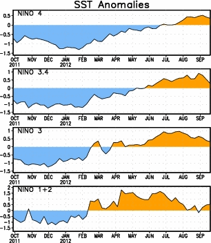
Giving credit to the earlier ECMWF's forecast of cooling this month into next month.
0 likes


Re: ENSO Updates
wxman57 wrote:No El Nino could mean a nice warm winter for me...
Not so fast wxman! I wouldn't cancel that flight to Tahiti just yet! The anomaly map verifies what's happening at the subsurface between 160-180w east of new guinea
0 likes
The above post and any post by Ntxw is NOT an official forecast and should not be used as such. It is just the opinion of the poster and may or may not be backed by sound meteorological data. It is NOT endorsed by any professional institution including Storm2k. For official information, please refer to NWS products.
Help support Storm2K!
Help support Storm2K!
Re:
NDG wrote:What El Nino?
I think we will have to wait a lot longer before El Nino gets declared, if at all.
Even if 3.4 cools to 0.0 for the next two weeks, the ONI (trimonthly) covering JAS (based on averaging the weeklies) would still be up at +0.5. JJA averaged +0.5 based on the weeklies (ignoring what the table shows...it is so out of whack with regard to the weeklies, as the NOAA/NCEP people told me a couple of weeks back, that they are ignoring the latest ONI table #'s and are depending on the weeklies for their weekly Monday ENSO resports). So, assuming 3.4 would subsequently warm back up, there'd be no break in the +0.5+ ONI #'s. So, if this occurs, and the ONI's go on to have five in a row of +0.5+, then we'd already be within El Nino once it is declared retroactively
People should look at what the Nino 3.4 weeklies did between August and mid Sep. in both 1991 and 1994 before declaring this Nino dead:
1991: went up to +0.9 on 7/31 but cooled 0.8 to only +0.1 on 9/11 and was still only +0.4 on 9/25. The weeklies then rose all the way to +2.0 on 12/18. The ASO ONI went down only 0.1 from the earlier max before rebounding and remained safely above the +0.5 threshold. The ONI then rose 0.9 to its max in DJF that was above +1.5....so it peaked as a strong Nino.
1994: went up to +0.7 on 8/10 but cooled 0.6 to only +0.1 on 9/14 and was still only +0.2 on 9/21. The weeklies then rose all the way to +1.4 on 11/30. The ASO ONI actually rose 0.1 from JAS (and was already at the +0.5+ threshold). The ONI then rose to above +1.0 at its max in NDJ...so it peaked as a moderate Nino.
2012: went up to +0.9 on 8/29 but cooled 0.6 to +0.3 on 9/19.
Do you see the similar patterns?
0 likes
Personal Forecast Disclaimer:
The posts in this forum are NOT official forecasts and should not be used as such. They are just the opinion of the poster and may or may not be backed by sound meteorological data. They are NOT endorsed by any professional institution or storm2k.org. For official information, please refer to the NHC and NWS products.
The posts in this forum are NOT official forecasts and should not be used as such. They are just the opinion of the poster and may or may not be backed by sound meteorological data. They are NOT endorsed by any professional institution or storm2k.org. For official information, please refer to the NHC and NWS products.
I agree NDG the chances for a moderate or higher is lessened until we see warming again. Those models though didn't see the cooling a month ago especially the cfs which is dragging all the others too low in a consensus. So who knows what they will show a month from now.
0 likes
The above post and any post by Ntxw is NOT an official forecast and should not be used as such. It is just the opinion of the poster and may or may not be backed by sound meteorological data. It is NOT endorsed by any professional institution including Storm2k. For official information, please refer to NWS products.
Help support Storm2K!
Help support Storm2K!
Who is online
Users browsing this forum: Ulf and 157 guests