


Moderator: S2k Moderators


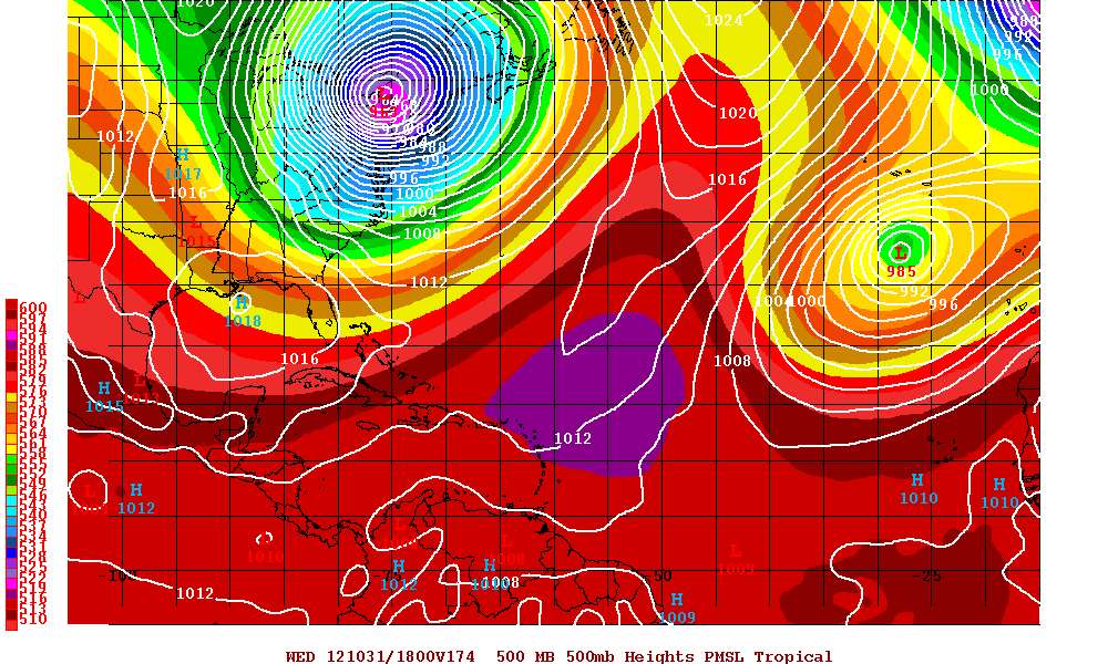
tolakram wrote:Good grief
saved image


Aric Dunn wrote:12z cmc come left. very near south florida. wobbles wnw to nw like the gfs and euro just sooner.
http://moe.met.fsu.edu/cgi-bin/cmctc2.c ... =Animation
jlauderdal wrote:tolakram wrote:Good grief
saved image
think there will be some cold air coming down the backside of that monster..

gatorcane wrote:Aric Dunn wrote:12z cmc come left. very near south florida. wobbles wnw to nw like the gfs and euro just sooner.
http://moe.met.fsu.edu/cgi-bin/cmctc2.c ... =Animation
Wow that is VERY close to SE Florida....if the ECMWF shifts left also, NHC will be forced to shift the track more left again at 5pm EST closer to South Florida.
Aric what kind of winds would you think would we see in SE Florida with it that close?

artist wrote:jlauderdal wrote:tolakram wrote:Good grief
saved image
think there will be some cold air coming down the backside of that monster..
yeah, I was thinking the same, just as Wilma did, if I recall correctly.
gatorcane wrote:Aric Dunn wrote:12z cmc come left. very near south florida. wobbles wnw to nw like the gfs and euro just sooner.
http://moe.met.fsu.edu/cgi-bin/cmctc2.c ... =Animation
Wow that is VERY close to SE Florida....if the ECMWF shifts left also, NHC will be forced to shift the track more left again at 5pm EST closer to South Florida.
Aric what kind of winds would you think would we see in SE Florida with it that close?
EDIT: looks like it clobbers the NE CONUS on this run.
tolakram wrote:Here's the hard left turn.


adam0983 wrote:I am waiting to see what the Euro model will show this afternoon. If it shifts closer to Florida do you think Hurricane watches or Warnings will be needed?
DESTRUCTION5 wrote:adam0983 wrote:I am waiting to see what the Euro model will show this afternoon. If it shifts closer to Florida do you think Hurricane watches or Warnings will be needed?
Hard to have either of those when they expect it to be a TS as it passes by..


Evil Jeremy wrote:DESTRUCTION5 wrote:adam0983 wrote:I am waiting to see what the Euro model will show this afternoon. If it shifts closer to Florida do you think Hurricane watches or Warnings will be needed?
Hard to have either of those when they expect it to be a TS as it passes by..
They could put up a Hurricane Watch even if they expect a TS. Bahamas have a H-watch right now.

Users browsing this forum: No registered users and 45 guests

