ATL: SANDY - Remnants - Discussion

Moderator: S2k Moderators

Message
Author
User avatar
CDO62
S2K Supporter
S2K Supporter
Posts: 105
Joined: Mon Sep 19, 2005 3:19 pm
Location: Tampa,FL

Re: ATL: SANDY - Hurricane - Discussion

#721 Postby CDO62 » Wed Oct 24, 2012 8:15 pm

boca wrote:Look at the floatethis is moving due north it was over Jamaica since it emerged off the coast its been moving NNE or 30 degrees.

http://www.ssd.noaa.gov/PS/TROP/floater ... -long.html


I agree. Looks to be a little East of forecast points. Will it wobble back West?
0 likes   

User avatar
Bocadude85
Category 5
Category 5
Posts: 2991
Age: 38
Joined: Mon Apr 18, 2005 2:20 pm
Location: Honolulu,Hi

Re: ATL: SANDY - Hurricane - Discussion

#722 Postby Bocadude85 » Wed Oct 24, 2012 8:17 pm

First rainbands starting to move ashore in South Florida.

http://radar.weather.gov/radar.php?rid=AMX&product=N0R&overlay=11101111&loop=yes
0 likes   

ozonepete
Professional-Met
Professional-Met
Posts: 4743
Joined: Mon Sep 07, 2009 3:23 pm
Location: From Ozone Park, NYC / Now in Brooklyn, NY

Re: ATL: SANDY - Hurricane - Discussion

#723 Postby ozonepete » Wed Oct 24, 2012 8:17 pm

cycloneye wrote:
cpdaman wrote:
boca wrote:Look at the floatethis is moving due north it was over Jamaica since it emerged off the coast its been moving NNE or 30 degrees.

http://www.ssd.noaa.gov/PS/TROP/floater ... -long.html


yes it looks NNE since leaving jamaica (i'd say 20 deg) , and 40 degrees is NE


The second pass by recon will tell us the real movement.


Yes. Remember you are wobble watching and need an avergae motion of at least a few hours, preferably at least 6.
0 likes   

User avatar
boca
Category 5
Category 5
Posts: 6367
Age: 60
Joined: Mon Dec 15, 2003 8:49 am
Location: Boca Raton,FL

Re: ATL: SANDY - Hurricane - Discussion

#724 Postby boca » Wed Oct 24, 2012 8:18 pm

CDO62 wrote:
boca wrote:Look at the floatethis is moving due north it was over Jamaica since it emerged off the coast its been moving NNE or 30 degrees.

http://www.ssd.noaa.gov/PS/TROP/floater ... -long.html


I agree. Looks to be a little East of forecast points. Will it wobble back West?


My point is the more it moves NNE we will have less influence here in Florida.
0 likes   

HurricaneFrances04
Category 2
Category 2
Posts: 597
Joined: Mon Jun 25, 2012 8:09 am
Location: Fort Lauderdale, Florida

Re: ATL: SANDY - Hurricane - Discussion

#725 Postby HurricaneFrances04 » Wed Oct 24, 2012 8:23 pm

Personally, I'm waiting for Sandy to get to the Central Bahamas before worrying about any wobbles.

Personal Forecast Disclaimer:
The posts in this forum are NOT official forecast and should not be used as such. They are just the opinion of the poster and may or may not be backed by sound meteorological data. They are NOT endorsed by any professional institution or storm2k.org. For official information, please refer to the NHC and NWS products.
0 likes   

User avatar
bahamaswx
Category 5
Category 5
Posts: 1542
Joined: Sat Sep 13, 2003 1:11 am
Location: Georgetown, Bahamas

Re: ATL: SANDY - Hurricane - Discussion

#726 Postby bahamaswx » Wed Oct 24, 2012 8:26 pm

HurricaneFrances04 wrote:Personally, I'm waiting for Sandy to get to the Central Bahamas before worrying about any wobbles.

Personal Forecast Disclaimer:
The posts in this forum are NOT official forecast and should not be used as such. They are just the opinion of the poster and may or may not be backed by sound meteorological data. They are NOT endorsed by any professional institution or storm2k.org. For official information, please refer to the NHC and NWS products.


I'm worried about them now. :)
0 likes   

ozonepete
Professional-Met
Professional-Met
Posts: 4743
Joined: Mon Sep 07, 2009 3:23 pm
Location: From Ozone Park, NYC / Now in Brooklyn, NY

Re: ATL: SANDY - Hurricane - Discussion

#727 Postby ozonepete » Wed Oct 24, 2012 8:35 pm

Gigantic circulation. Haven't seen many this big. Look at little Tony off to the northeast, lol.

Image
0 likes   

User avatar
Weatherguy173
Tropical Storm
Tropical Storm
Posts: 148
Age: 31
Joined: Wed Aug 01, 2012 10:55 pm
Location: Short Hills NJ

Re: ATL: SANDY - Hurricane - Discussion

#728 Postby Weatherguy173 » Wed Oct 24, 2012 8:36 pm

[quote="ozonepete"]Gigantic circulation. Haven't seen many this big.

how many miles do u think?
0 likes   
Nothing I say is intended to be a forecast; it's only food for thought and friendly advice!

User avatar
boca
Category 5
Category 5
Posts: 6367
Age: 60
Joined: Mon Dec 15, 2003 8:49 am
Location: Boca Raton,FL

Re: ATL: SANDY - Hurricane - Discussion

#729 Postby boca » Wed Oct 24, 2012 8:38 pm

I'd say about 700 miles wide from north to south
0 likes   

ozonepete
Professional-Met
Professional-Met
Posts: 4743
Joined: Mon Sep 07, 2009 3:23 pm
Location: From Ozone Park, NYC / Now in Brooklyn, NY

Re: ATL: SANDY - Hurricane - Discussion

#730 Postby ozonepete » Wed Oct 24, 2012 8:41 pm

:uarrow: No. More. I've just been measuring. 900 miles across and over 1,000 miles from north to south. Extremely large hurricane.
0 likes   

ozonepete
Professional-Met
Professional-Met
Posts: 4743
Joined: Mon Sep 07, 2009 3:23 pm
Location: From Ozone Park, NYC / Now in Brooklyn, NY

Re: ATL: SANDY - Hurricane - Discussion

#731 Postby ozonepete » Wed Oct 24, 2012 8:42 pm

For reference, it's 912 miles by air from Tampa, FL to Corpus Christi, TX.
0 likes   

ozonepete
Professional-Met
Professional-Met
Posts: 4743
Joined: Mon Sep 07, 2009 3:23 pm
Location: From Ozone Park, NYC / Now in Brooklyn, NY

Re: ATL: SANDY - Hurricane - Discussion

#732 Postby ozonepete » Wed Oct 24, 2012 8:44 pm

Look at it sucking inflow from the eastern Pacific. Wow.

http://www.ssd.noaa.gov/goes/east/tatl/flash-avn.html
0 likes   

User avatar
Bocadude85
Category 5
Category 5
Posts: 2991
Age: 38
Joined: Mon Apr 18, 2005 2:20 pm
Location: Honolulu,Hi

Re: ATL: SANDY - Hurricane - Discussion

#733 Postby Bocadude85 » Wed Oct 24, 2012 8:48 pm

ozonepete wrote:Look at it sucking inflow from the eastern Pacific. Wow.

http://www.ssd.noaa.gov/goes/east/tatl/flash-avn.html


In that loop you can also see the jog to the NNE everyone was talking about.. but at the end of the loop you can see Sandy starting a jog to the NNW
0 likes   

User avatar
fci
S2K Supporter
S2K Supporter
Posts: 3324
Joined: Tue Sep 14, 2004 10:29 am
Location: Lake Worth, FL

Re:

#734 Postby fci » Wed Oct 24, 2012 8:48 pm

Nate-Gillson wrote:I wouldn't be surprised if Sandy is already a borderline cat 3, much less a cat 4.

I doubt it, there is land interaction starting.
0 likes   
Personal Forecast Disclaimer:
My posts are just my opinion and are most likely not backed by sound meteorological data. They are NOT endorsed by any professional institution or storm2k.org. For official information, please refer to the NHC and NWS products.
Bottom line is that I am just expressing my opinion!!!

User avatar
Miami Storm Tracker
Category 4
Category 4
Posts: 910
Age: 67
Joined: Sun Jun 13, 2010 10:12 pm
Location: Key Largo, Fla.
Contact:

Re: ATL: SANDY - Hurricane - Discussion

#735 Postby Miami Storm Tracker » Wed Oct 24, 2012 8:48 pm

ozonepete wrote::uarrow: No. More. I've just been measuring. 900 miles across and over 1,000 miles from north to south. Extremely large hurricane.


That would be the total circulation your talking about correct. The wind field and rain would only be several hundred miles or so, or am I way off here.
0 likes   

SootyTern
S2K Supporter
S2K Supporter
Posts: 316
Age: 56
Joined: Sun Sep 05, 2004 5:09 pm
Location: NYC (formerly Homestead, FL)

#736 Postby SootyTern » Wed Oct 24, 2012 8:50 pm

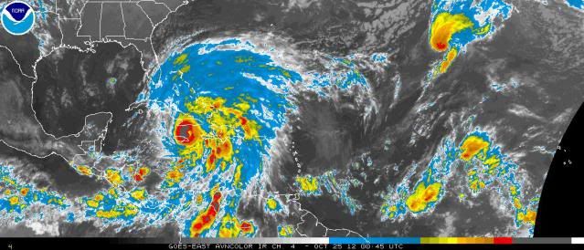
Something weird just happened that may be making the storm appear to have gone more NE recently. A big burst of convection on the W side appears to have blown up and 'squished' the eye into a teardrop shape temporarily. Burst now seems to be wrapping around to the S and SE and the eye looks more circular again, and the storm seems to be back on track to be close to the next NHC forecast point, or maybe a tad east of the point it just passed.


Personal Forecast Disclaimer:
The posts in this forum are NOT official forecast and should not be used as such. They are just the opinion of the poster and may or may not be backed by sound meteorological data. They are NOT endorsed by any professional institution or storm2k.org. For official information, please refer to the NHC and NWS products.
0 likes   

User avatar
lester
S2K Supporter
S2K Supporter
Posts: 1305
Age: 36
Joined: Sat Aug 27, 2005 5:21 pm
Location: Washington, DC
Contact:

#737 Postby lester » Wed Oct 24, 2012 8:51 pm

Sandy's pressure has gone down to 956 mbs preliminary according to Recon
0 likes   

User avatar
StormingB81
S2K Supporter
S2K Supporter
Posts: 5676
Age: 43
Joined: Thu Aug 27, 2009 1:45 am
Location: Rockledge, Florida

#738 Postby StormingB81 » Wed Oct 24, 2012 8:51 pm

The record is 1380 by Super Typhoons Tip in 1974 That is wind field only.
0 likes   

HurrMark
Category 2
Category 2
Posts: 769
Joined: Tue Aug 12, 2008 10:18 pm
Location: Somerville, MA

Re: Re:

#739 Postby HurrMark » Wed Oct 24, 2012 8:52 pm

fci wrote:
Nate-Gillson wrote:I wouldn't be surprised if Sandy is already a borderline cat 3, much less a cat 4.

I doubt it, there is land interaction starting.


I think it has a few more hours to make a run...wouldn't surprise me to see a cat 3.
0 likes   

User avatar
NDG
S2K Supporter
S2K Supporter
Posts: 15446
Joined: Sun Jul 09, 2006 10:14 pm
Location: Orlando, FL

Re: ATL: SANDY - Hurricane - Discussion

#740 Postby NDG » Wed Oct 24, 2012 8:53 pm

Looks like its pressure continues to drop, down to at least 960mb, lets see what the VDM shows.
0 likes   


Return to “2012”

Who is online

Users browsing this forum: No registered users and 6 guests