Discussion (May 18-19-20-21) Moore Tornado EF-5 from NWS
Moderator: S2k Moderators
Forum rules
The posts in this forum are NOT official forecast and should not be used as such. They are just the opinion of the poster and may or may not be backed by sound meteorological data. They are NOT endorsed by any professional institution or STORM2K.
-
WeatherGuesser
- Category 5

- Posts: 2672
- Joined: Tue Jun 29, 2010 6:46 am
-
WeatherGuesser
- Category 5

- Posts: 2672
- Joined: Tue Jun 29, 2010 6:46 am
-
WeatherGuesser
- Category 5

- Posts: 2672
- Joined: Tue Jun 29, 2010 6:46 am
-
WeatherGuesser
- Category 5

- Posts: 2672
- Joined: Tue Jun 29, 2010 6:46 am
-
WeatherGuesser
- Category 5

- Posts: 2672
- Joined: Tue Jun 29, 2010 6:46 am
- cycloneye
- Admin

- Posts: 149503
- Age: 69
- Joined: Thu Oct 10, 2002 10:54 am
- Location: San Juan, Puerto Rico
Re: Discussion of Severe Weather Outbreak for May 18-19-20
Here is the latest from Dr Greg Forbes.
Dr. Forbes updated numbers..
Saturday, May 18
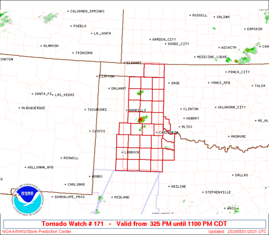
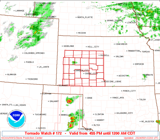
A severe thunderstorm and tornado outbreak begins by late afternoon and continues to around midnight in the extreme east TX panhandle, west and north-central OK, west and central NE, west and central KS, SD, extreme south-central and southeast ND, north MN.
TOR:CON -
KS southwest - 6
KS northwest - 5
KS central - 4 to 5
MN southwest - 3
MN north - 2 to 3
ND southeast, south-central - 3
NE southwest - 4
NE northwest - 3
NE central - 4
OK northwest, north-central - 5
OK southwest - 3
SD - 3 to 4
TX extreme east panhandle - 3
other areas - less than 2
Saturday night/overnight: Severe thunderstorms spread into east KS, east NE, west and central IA, west and north MO. TOR:CON - 3 or less.
Sunday, May 19
Severe thunderstorm and tornado outbreak in central and northeast OK, north-central TX, central and east KS, east NE, IA, west MO, east SD, southeast ND, central and south MN, west-central and southwest WI, northwest IL.
TOR:CON -
IA central - 5 to 6
IA west - 4 to 5
IA east - 3
IL northwest - 3
KS east - 7
KS central - 4
MN central, south - 2 to 3
MO southwest - 4
MO northwest - 6
ND southeast - 3
NE east - 4
OK central, northeast - 7
SD east - 3
TX north-central - 4 (concerns about whether cap will break)
WI west-central, southwest - 3
other areas - less than 2
Sunday night/overnight: Severe thunderstorms continue across northeast OK, northwest AR, MO.
Monday, May 20
Severe thunderstorms in north-central TX, central and east OK, east KS, southwest, central, north MO, west-central and north IL, extreme north IN, MI, south and central MN, WI, north and east IA.
TOR:CON -
IA north, east - 3
IL west-central, north - 3
IN extreme north - 3
KS east- 4
MI - 3
MN south, central - 3
MO southwest - 5
MO central - 4
MO north - 3
OK central, east - 5
TX north-central - 3
WI - 3
other areas - less than 2
0 likes
Visit the Caribbean-Central America Weather Thread where you can find at first post web cams,radars
and observations from Caribbean basin members Click Here
and observations from Caribbean basin members Click Here
-
WeatherGuesser
- Category 5

- Posts: 2672
- Joined: Tue Jun 29, 2010 6:46 am
- cycloneye
- Admin

- Posts: 149503
- Age: 69
- Joined: Thu Oct 10, 2002 10:54 am
- Location: San Juan, Puerto Rico
Re: Discussion of Severe Weather Outbreak for May 18-19-20
Wow,look at this photo of tornado in SW Rozel Kansas. You have another option to post videos and photos and that is in the Sticky 2013 U.S Severe Weather Season (Videos-Photos-Stats-Forecast thread


0 likes
Visit the Caribbean-Central America Weather Thread where you can find at first post web cams,radars
and observations from Caribbean basin members Click Here
and observations from Caribbean basin members Click Here
Return to “USA & Caribbean Weather”
Who is online
Users browsing this forum: No registered users and 115 guests


