ATL: ANDREA - Post-Tropical

Moderator: S2k Moderators

Message
Author
psyclone
S2K Supporter
S2K Supporter
Posts: 4762
Joined: Wed Aug 24, 2005 9:04 pm
Location: palm harbor fl

Re: ATL: INVEST 91L

#221 Postby psyclone » Mon Jun 03, 2013 11:33 pm

floridasun78 wrote:
boca wrote:I persoanally see a lot of rain heading north out of the Keys heading into S Fl.

but rain may last only one day and be gone past fl quick this may never see be td

Check the hydrologic outlook for your CWA:

HYDROLOGIC OUTLOOK
FLC011-021-043-051-086-087-099-041200-

HYDROLOGIC OUTLOOK
NATIONAL WEATHER SERVICE MIAMI FL
342 AM EDT MON JUN 3 2013

...HEAVY RAINFALL POSSIBLE THIS WEEK...

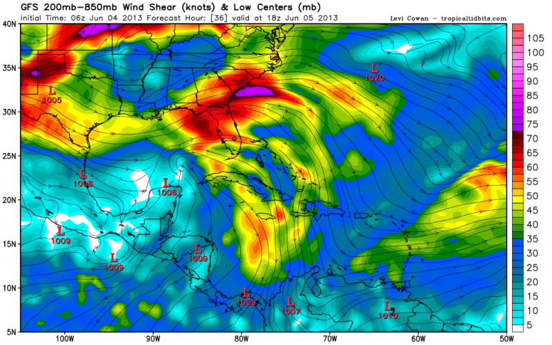
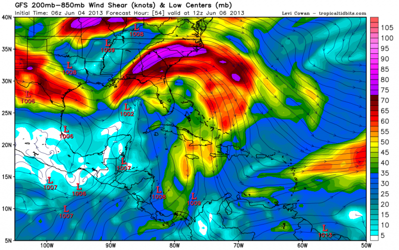
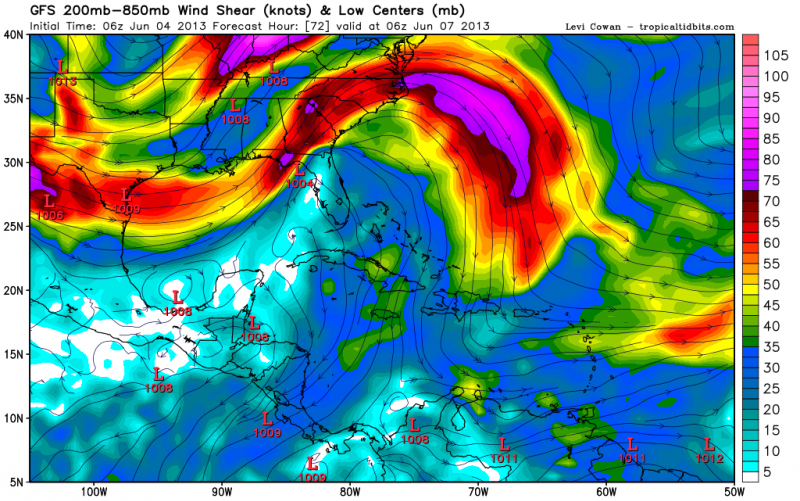
THE LATEST LONG RANGE MODELS ARE STILL SHOWING THE DEVELOPMENT OF
AN AREA OF LOW PRESSURE ACROSS THE YUCATAN AND SOUTHERN GULF OF
MEXICO EARLY THIS WEEK. THIS AREA OF LOW PRESSURE IS FORECAST TO
TRACK SLOWLY TO THE NORTHEAST TOWARDS CENTRAL FLORIDA TOMORROW THROUGH
THURSDAY. SOUTHERLY FLOW IS EXPECTED TO DEVELOP...BRINGING IN DEEP
TROPICAL MOISTURE TO SOUTH FLORIDA. THIS WILL INCREASE THE THREAT
OF VERY HEAVY RAINFALL AND FLOODING...WITH THE HEAVIEST RAINS
LIKELY FALLING IN THE TOMORROW THROUGH THURSDAY PERIOD. AREA WIDE
RAINFALL ACCUMULATIONS OF 4 TO 8 INCHES ARE POSSIBLE WITH EVEN
HIGHER LOCALIZED AMOUNTS OVER THE NEXT 5 DAYS. FLOOD WATCHES MAY
BECOME NECESSARY DURING THE MID WEEK PERIOD...SO INTERESTS ARE
ENCOURAGED TO MONITOR THE LATEST FORECASTS AS THIS SITUATION
UNFOLDS.
0 likes   

psyclone
S2K Supporter
S2K Supporter
Posts: 4762
Joined: Wed Aug 24, 2005 9:04 pm
Location: palm harbor fl

#222 Postby psyclone » Mon Jun 03, 2013 11:42 pm

this mess does not need to be numbered/named to unload 5-10"+ on someone and even some severe wx. in fact, there will be negligible, almost undiscernable differences in the sensible wx between no designation,td or minimal ts. it's going to be a protracted, wet mess and someone is likely going to get swamped pretty good. it is probably a mistake to obsess over td or ts status and a more worthwhile endeavor to instead focus on where the firehose of moisture is aimed.

Personal Forecast Disclaimer:
The posts in this forum are NOT official forecast and should not be used as such. They are just the opinion of the poster and may or may not be backed by sound meteorological data. They are NOT endorsed by any professional institution or storm2k.org. For official information, please refer to the NHC and NWS products.
0 likes   

User avatar
Miami Storm Tracker
Category 4
Category 4
Posts: 910
Age: 67
Joined: Sun Jun 13, 2010 10:12 pm
Location: Key Largo, Fla.
Contact:

Re:

#223 Postby Miami Storm Tracker » Mon Jun 03, 2013 11:59 pm

floridasun78 wrote:http://www.ssd.noaa.gov/PS/TROP/floaters/91L/flash-wv-short.html look at gulf dry air


You are correct about the dry air, the problem is that all the clouds and rain are ahead of the dry air. So that will need to move northeast into FLA before the dry air can move in if it pushes south and east that far.
0 likes   

JonathanBelles
Professional-Met
Professional-Met
Posts: 11430
Age: 35
Joined: Sat Dec 24, 2005 9:00 pm
Location: School: Florida State University (Tallahassee, FL) Home: St. Petersburg, Florida
Contact:

#224 Postby JonathanBelles » Tue Jun 04, 2013 12:03 am

Does anyone have any good Google Earth (KML) model files? The one that I had from last year edited itself and now all of the lines for spaghetti models are way too skinny. I really don't feel like going in and editing each one individually every time to make them visible.

Thanks in advance!
0 likes   

TheStormExpert

#225 Postby TheStormExpert » Tue Jun 04, 2013 12:15 am

Image
The Weather Channel's Rainfall Forecast through the end of the week. This was from Monday afternoon.
0 likes   

User avatar
lester
S2K Supporter
S2K Supporter
Posts: 1305
Age: 36
Joined: Sat Aug 27, 2005 5:21 pm
Location: Washington, DC
Contact:

#226 Postby lester » Tue Jun 04, 2013 12:23 am

1. SHOWERS AND THUNDERSTORMS ASSOCIATED WITH A WEAK AREA OF LOW
PRESSURE OVER THE SOUTH-CENTRAL GULF OF MEXICO HAVE CHANGED LITTLE
IN ORGANIZATION TONIGHT. HOWEVER...SURFACE PRESSURES ARE FALLING...
AND ADDITIONAL SLOW DEVELOPMENT IS POSSIBLE DURING THE NEXT COUPLE
OF DAYS DESPITE MARGINALLY FAVORABLE ENVIRONMENTAL CONDITIONS. THIS
SYSTEM HAS A MEDIUM CHANCE...30 PERCENT...OF BECOMING A SUBTROPICAL
OR TROPICAL CYCLONE DURING THE NEXT 48 HOURS AS IT DRIFTS GENERALLY
NORTHWARD. REGARDLESS OF DEVELOPMENT... LOCALLY HEAVY RAINS ARE
LIKELY IN ASSOCIATION WITH THE LOW OVER PORTIONS OF THE YUCATAN
PENINSULA...CENTRAL AND WESTERN CUBA...AS WELL AS THE FLORIDA KEYS
AND THE FLORIDA PENINSULA DURING THE NEXT SEVERAL DAYS.

ELSEWHERE...TROPICAL CYCLONE FORMATION IS NOT EXPECTED DURING THE
NEXT 48 HOURS.
0 likes   

Chris_in_Tampa
Category 5
Category 5
Posts: 5075
Age: 41
Joined: Thu Jun 21, 2007 11:06 pm
Location: Tampa, Florida, USA
Contact:

Re:

#227 Postby Chris_in_Tampa » Tue Jun 04, 2013 12:35 am

JonathanBelles wrote:Does anyone have any good Google Earth (KML) model files? The one that I had from last year edited itself and now all of the lines for spaghetti models are way too skinny. I really don't feel like going in and editing each one individually every time to make them visible.

Thanks in advance!

How much thicker might you want them?

I have mine here:
http://www.tropicalatlantic.com/models/ ... _Basin.kmz

I could make them a little thicker. What Google Earth thickness would you prefer and I can consider it. I'll make them a tad thicker right now. I think originally I made them small because in Google Earth on some computers the lines seemed to appear bigger, so a bigger size might be really big on some computers, but I have not revisited the issue in awhile.

That is what is nice with Google Maps. You can adjust the line thickness with 1 click:
http://www.tropicalatlantic.com/models/ ... =1&large=1
0 likes   

JonathanBelles
Professional-Met
Professional-Met
Posts: 11430
Age: 35
Joined: Sat Dec 24, 2005 9:00 pm
Location: School: Florida State University (Tallahassee, FL) Home: St. Petersburg, Florida
Contact:

Re: Re:

#228 Postby JonathanBelles » Tue Jun 04, 2013 12:38 am

Chris_in_Tampa wrote:
JonathanBelles wrote:Does anyone have any good Google Earth (KML) model files? The one that I had from last year edited itself and now all of the lines for spaghetti models are way too skinny. I really don't feel like going in and editing each one individually every time to make them visible.

Thanks in advance!

How much thicker might you want them?

I have mine here:
http://www.tropicalatlantic.com/models/ ... _Basin.kmz

I could make them a little thicker. What Google Earth thickness would you prefer and I can consider it. I'll make them a tad thicker right now. I think originally I made them small because in Google Earth on some computers the lines seemed to appear bigger, so a bigger size might be really big on some computers, but I have not revisited the issue in awhile.

That is what is nice with Google Maps. You can adjust the line thickness with 1 click:
http://www.tropicalatlantic.com/models/ ... =1&large=1


I think I originally got mine from tropicalatlantic. I'd like them to be between 2.5 and 3.0.
0 likes   

Chris_in_Tampa
Category 5
Category 5
Posts: 5075
Age: 41
Joined: Thu Jun 21, 2007 11:06 pm
Location: Tampa, Florida, USA
Contact:

#229 Postby Chris_in_Tampa » Tue Jun 04, 2013 12:45 am

I wouldn't be able to go up that high. I might bump them up a few tenths. The problem is when zoomed out then they look so big and a lot of media use my plots that way. You could run the system yourself if you wanted to run it on your site and change it, but I wouldn't be able to change the default on my site that high.
0 likes   

Chris_in_Tampa
Category 5
Category 5
Posts: 5075
Age: 41
Joined: Thu Jun 21, 2007 11:06 pm
Location: Tampa, Florida, USA
Contact:

#230 Postby Chris_in_Tampa » Tue Jun 04, 2013 12:49 am

Although out of curiosity, which plots are you talking about, the spaghetti lines without dots or the full plots with dots. I have different configurations in my system for both, though each are currently set at 1.0.
0 likes   

User avatar
Nimbus
Category 5
Category 5
Posts: 5300
Joined: Mon Jul 19, 2004 10:54 am

#231 Postby Nimbus » Tue Jun 04, 2013 5:36 am

The front has dug south of Cedar key Florida and there is currently plenty of dry air and sheer in the gulf. If 91L was a well developed system it probably would get picked up by the digging trough and pulled NE out quickly over the Florida peninsula.

Steering for a weak system at the surface would be closer to the BAM Shallow which might leave the surface low in the gulf after the front lifts out. Once the dry sheer lets up the surface feature may build an envelope of moisture. NHC said surface pressures are dropping and sheer will diminish if the front doesn't stall over Tampa.

For now it looks like mostly a rain event south of the front as moisture is steered northeastward over south Florida.
0 likes   

User avatar
robbielyn
Category 5
Category 5
Posts: 1298
Joined: Wed May 07, 2003 9:45 am
Location: brooksville, fl

#232 Postby robbielyn » Tue Jun 04, 2013 5:55 am

nice blow up of convection just off east coast of yucatan
0 likes   
Robbielyn McCrary
I know just about enough to sound like I know what I'm talking about sometimes. But for your safety please follow the nhc for truly professional forecasting. :D

Meow

Re:

#233 Postby Meow » Tue Jun 04, 2013 6:06 am

lester wrote:1. SHOWERS AND THUNDERSTORMS ASSOCIATED WITH A WEAK AREA OF LOW
PRESSURE OVER THE SOUTH-CENTRAL GULF OF MEXICO HAVE CHANGED LITTLE
IN ORGANIZATION TONIGHT. HOWEVER...SURFACE PRESSURES ARE FALLING...
AND ADDITIONAL SLOW DEVELOPMENT IS POSSIBLE DURING THE NEXT COUPLE
OF DAYS DESPITE MARGINALLY FAVORABLE ENVIRONMENTAL CONDITIONS. THIS
SYSTEM HAS A MEDIUM CHANCE...30 PERCENT...OF BECOMING A SUBTROPICAL
OR TROPICAL CYCLONE DURING THE NEXT 48 HOURS AS IT DRIFTS GENERALLY
NORTHWARD. REGARDLESS OF DEVELOPMENT... LOCALLY HEAVY RAINS ARE
LIKELY IN ASSOCIATION WITH THE LOW OVER PORTIONS OF THE YUCATAN
PENINSULA...CENTRAL AND WESTERN CUBA...AS WELL AS THE FLORIDA KEYS
AND THE FLORIDA PENINSULA DURING THE NEXT SEVERAL DAYS.

ELSEWHERE...TROPICAL CYCLONE FORMATION IS NOT EXPECTED DURING THE
NEXT 48 HOURS.

We may see Subtropical Storm Andrea again...
0 likes   

User avatar
cycloneye
Admin
Admin
Posts: 145295
Age: 68
Joined: Thu Oct 10, 2002 10:54 am
Location: San Juan, Puerto Rico

Re: ATL: INVEST 91L

#234 Postby cycloneye » Tue Jun 04, 2013 6:34 am

Remains at 30%.

TROPICAL WEATHER OUTLOOK
NWS NATIONAL HURRICANE CENTER MIAMI FL
800 AM EDT TUE JUN 4 2013

FOR THE NORTH ATLANTIC...CARIBBEAN SEA AND THE GULF OF MEXICO...

SHOWERS AND THUNDERSTORMS ASSOCIATED WITH A WEAK AREA OF LOW
PRESSURE OVER THE CENTRAL GULF OF MEXICO HAVE NOT BECOME ANY BETTER
ORGANIZED SINCE YESTERDAY. MOST OF THE SHOWER ACTIVITY IS STILL
LOCATED EAST AND SOUTHEAST OF THE LOW DUE TO STRONG UPPER-LEVEL
WINDS. CONDITIONS COULD BECOME A LITTLE MORE FAVORABLE FOR SLOW
DEVELOPMENT DURING THE NEXT DAY OR TWO...BEFORE THE LOW INTERACTS
WITH AN UPPER-LEVEL TROUGH. THIS SYSTEM HAS A MEDIUM CHANCE...30
PERCENT...OF BECOMING A SUBTROPICAL OR TROPICAL CYCLONE DURING THE
NEXT 48 HOURS AS IT DRIFTS GENERALLY NORTHWARD OR NORTH-
NORTHEASTWARD. REGARDLESS OF DEVELOPMENT...LOCALLY HEAVY RAINS ARE
LIKELY TO CONTINUE OVER THE NORTHEASTERN YUCATAN PENINSULA...
CENTRAL AND WESTERN CUBA...AS WELL AS THE FLORIDA KEYS AND THE
FLORIDA PENINSULA DURING THE NEXT SEVERAL DAYS.

ELSEWHERE...TROPICAL CYCLONE FORMATION IS NOT EXPECTED DURING THE
NEXT 48 HOURS.

$$
FORECASTER AVILA
0 likes   
Visit the Caribbean-Central America Weather Thread where you can find at first post web cams,radars
and observations from Caribbean basin members Click Here

User avatar
NDG
S2K Supporter
S2K Supporter
Posts: 15446
Joined: Sun Jul 09, 2006 10:14 pm
Location: Orlando, FL

Re:

#235 Postby NDG » Tue Jun 04, 2013 6:47 am

Nimbus wrote:The front has dug south of Cedar key Florida and there is currently plenty of dry air and sheer in the gulf. If 91L was a well developed system it probably would get picked up by the digging trough and pulled NE out quickly over the Florida peninsula.

Steering for a weak system at the surface would be closer to the BAM Shallow which might leave the surface low in the gulf after the front lifts out. Once the dry sheer lets up the surface feature may build an envelope of moisture. NHC said surface pressures are dropping and sheer will diminish if the front doesn't stall over Tampa.

For now it looks like mostly a rain event south of the front as moisture is steered northeastward over south Florida.


The front is no where near Cedar Key, is west of Pensacola, one good way is also by looking at the surface dewpoints which the second image verifies.
The forecast does not show that the cold will move much eastward from where it is now. You might be confusing the trough and the cold front, two different things.

Image
Image
0 likes   

User avatar
NDG
S2K Supporter
S2K Supporter
Posts: 15446
Joined: Sun Jul 09, 2006 10:14 pm
Location: Orlando, FL

#236 Postby NDG » Tue Jun 04, 2013 6:53 am

By the looks of 91L this morning anyone would suggest near 0% chance of development, but the GFS has been persistent that over the next couple of days is when it will have the best chance of getting better organized. I gues we will wait and see.
0 likes   

User avatar
weatherwindow
Category 4
Category 4
Posts: 904
Joined: Mon Sep 20, 2004 9:48 am
Location: key west/ft lauderdale

Re: ATL: INVEST 91L

#237 Postby weatherwindow » Tue Jun 04, 2013 6:53 am

With respect to the current substantial shear, modelling earlier in the week, particularly the GFS and Euro, were suggesting that the shear would ease as the front/trough along the Gulf coast lifted to the Northeast. Is that solution still in the cards or will the shear r
remain? Any comment from the pros or the ams?...Rich
PS...The Lower Keys will need kayaks soon if the rain persists:)
PPS....Front Street in Key West was under 2' of water at high tide last nite
0 likes   

tolakram
Admin
Admin
Posts: 20009
Age: 62
Joined: Sun Aug 27, 2006 8:23 pm
Location: Florence, KY (name is Mark)

Re: ATL: INVEST 91L

#238 Postby tolakram » Tue Jun 04, 2013 7:11 am

weatherwindow wrote:With respect to the current substantial shear, modelling earlier in the week, particularly the GFS and Euro, were suggesting that the shear would ease as the front/trough along the Gulf coast lifted to the Northeast. Is that solution still in the cards or will the shear r
remain?


Unfortunately there are no reliable shear forecasts.

I'm looking at both upper level and mid level shear and both are very strong.

http://tropic.ssec.wisc.edu/real-time/w ... oom=&time=
0 likes   
M a r k
- - - - -
Join us in chat: Storm2K Chatroom Invite. Android and IOS apps also available.

The posts in this forum are NOT official forecasts and should not be used as such. Posts are NOT endorsed by any professional institution or STORM2K.org. For official information and forecasts, please refer to NHC and NWS products.

tolakram
Admin
Admin
Posts: 20009
Age: 62
Joined: Sun Aug 27, 2006 8:23 pm
Location: Florence, KY (name is Mark)

Re: ATL: INVEST 91L

#239 Postby tolakram » Tue Jun 04, 2013 7:17 am

Live visible java loop: http://wwwghcc.msfc.nasa.gov/cgi-bin/ge ... umframes=5

The center might be better defined this morning.

Image
0 likes   
M a r k
- - - - -
Join us in chat: Storm2K Chatroom Invite. Android and IOS apps also available.

The posts in this forum are NOT official forecasts and should not be used as such. Posts are NOT endorsed by any professional institution or STORM2K.org. For official information and forecasts, please refer to NHC and NWS products.

User avatar
NDG
S2K Supporter
S2K Supporter
Posts: 15446
Joined: Sun Jul 09, 2006 10:14 pm
Location: Orlando, FL

#240 Postby NDG » Tue Jun 04, 2013 7:30 am

Here is the GFS shear forecast over the next 72 hrs, it shows shear to diminish Wednesday and early Thursday ahead of the next trough of low pressure but as the low merges with the trough for it to acquire more of subtropical or extratropical entitiy.

Image
Image
Image
0 likes   


Return to “2013”

Who is online

Users browsing this forum: No registered users and 2 guests