
My swirl I have been rootin for may finally be chuggin some convection (24N, 89.5W)
http://www.ssd.noaa.gov/PS/TROP/floater ... -long.html
http://www.ssd.noaa.gov/PS/TROP/floater ... -long.html
Its a spit in the wind now. Watching if this goes to a full-blown hurl.
ATL: ANDREA - Post-Tropical
Moderator: S2k Moderators
looks like relocation of potential llc towards the deeper convection, based on vis satellite imagery...between lat 24 and 22 and long 89 and 87. defintly elongated, but more so seeming atm.
0 likes
Personal Forecast Disclaimer:
The posts in this forum are NOT official forecast and should not be used as such. They are just the opinion of the poster and may or may not be backed by sound meteorological data. They are NOT endorsed by any professional institution or storm2k.org. For official information, please refer to the NHC and NWS products.
The posts in this forum are NOT official forecast and should not be used as such. They are just the opinion of the poster and may or may not be backed by sound meteorological data. They are NOT endorsed by any professional institution or storm2k.org. For official information, please refer to the NHC and NWS products.

Re:
shortwave wrote:looks like relocation of potential llc towards the deeper convection, based on vis satellite imagery...between lat 24 and 22 and long 89 and 87. defintly elongated, but more so seeming atm.
0 likes

-
OuterBanker
- S2K Supporter

- Posts: 1761
- Joined: Wed Feb 26, 2003 10:53 am
- Location: Nags Head, NC
- Contact:
Re: ATL: INVEST 91L
My bad I guess wxman. The chart I was looking at was at 850 (roughly 5000ft). Is there a conversion formula that translates to ground level?
0 likes
-
Evil Jeremy

- S2K Supporter
- Posts: 5463
- Age: 32
- Joined: Mon Apr 10, 2006 2:10 pm
- Location: Los Angeles, CA
Re: Re:
ROCK wrote:shortwave wrote:looks like relocation of potential llc towards the deeper convection, based on vis satellite imagery...between lat 24 and 22 and long 89 and 87. defintly elongated, but more so seeming atm.
I agree...its in the process of barfing the naked LLC we are seeing and relocating towards the lowest pressure.
91L has been trying to make that relocation since last night, and time is ruNning out. If it does relocate though, the track should shift from northern Florida to the Middle of the state, maybe a little north of Tampa.
0 likes
Frances 04 / Jeanne 04 / Katrina 05 / Wilma 05 / Fay 08 / Debby 12 / Andrea 13 / Colin 16 / Hermine 16 / Matthew 16 / Irma 17
-
wxman57

- Moderator-Pro Met

- Posts: 23175
- Age: 68
- Joined: Sat Jun 21, 2003 8:06 pm
- Location: Houston, TX (southwest)
Re: ATL: INVEST 91L
I don't see any LLC forming closer to the convection yet, just a broad circulation 250 miles across well west of the convection. What typically happens in these cases is that an LLC does eventually form near the convection. Just don't see it yet.
0 likes
Re: ATL: INVEST 91L
AMSU Satellite Analysis has bumped up estimated winds to 30 knots.
http://rammb.cira.colostate.edu/product ... 051200.GIF
http://rammb.cira.colostate.edu/product ... 051200.GIF
0 likes
Re: ATL: INVEST 91L
Warm core at 1C and no boundary-layer inversion
http://rammb.cira.colostate.edu/product ... 8_TANO.GIF
http://rammb.cira.colostate.edu/product ... 8_TANO.GIF
0 likes
-
Extratropical94

- Professional-Met

- Posts: 3545
- Age: 31
- Joined: Wed Oct 20, 2010 6:36 am
- Location: Hamburg, Germany
- Contact:
Thanks Dave for the response.
0 likes
54° 11' 59'' N, 9° 9' 20'' E
Boomer Sooner!
Go Broncos! Go Cards!
Clinching counties, one at a time: https://mob-rule.com/user-gifs/USA/xtrp94.gif
- Daniel
Boomer Sooner!
Go Broncos! Go Cards!
Clinching counties, one at a time: https://mob-rule.com/user-gifs/USA/xtrp94.gif
- Daniel

Re: ATL: INVEST 91L
wxman57 wrote:I don't see any LLC forming closer to the convection yet, just a broad circulation 250 miles across well west of the convection. What typically happens in these cases is that an LLC does eventually form near the convection. Just don't see it yet.
I totally agree although I wish it would hurry up and consolidate but it doesn't even look like its trying to do that yet. Its quite a distance from the main convection. that dry air sure isn't helping any.
0 likes
Robbielyn McCrary
I know just about enough to sound like I know what I'm talking about sometimes. But for your safety please follow the nhc for truly professional forecasting.
I know just about enough to sound like I know what I'm talking about sometimes. But for your safety please follow the nhc for truly professional forecasting.
-
Ikester
- Professional-Met
- Posts: 361
- Age: 40
- Joined: Mon Jun 21, 2010 5:00 pm
- Location: Jacksonville, FL
Re: ATL: INVEST 91L
Quick side note here but I believe in 2014 (2015?) the National Hurricane Center will be able to issue a tropical storm watches for a stretch of coast (in this case, the big bend of Florida) even though a storm hasn't developed yet. It's in the testing phase right now. Could debut next year.
0 likes
-
tolakram
- Admin

- Posts: 20186
- Age: 62
- Joined: Sun Aug 27, 2006 8:23 pm
- Location: Florence, KY (name is Mark)
Re: ATL: INVEST 91L
Live visible loop (Java required): http://wwwghcc.msfc.nasa.gov/cgi-bin/ge ... te=ir1.pal
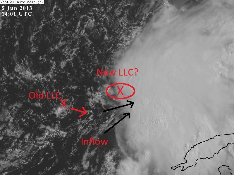
Clearly inflow into the blob from the SW now, IMO there may be an LLC forming.

Clearly inflow into the blob from the SW now, IMO there may be an LLC forming.
0 likes
M a r k
- - - - -
Join us in chat: Storm2K Chatroom Invite. Android and IOS apps also available.
The posts in this forum are NOT official forecasts and should not be used as such. Posts are NOT endorsed by any professional institution or STORM2K.org. For official information and forecasts, please refer to NHC and NWS products.

Re: ATL: INVEST 91L
Whatever this is, I'm about in the middle of it. Aboard the Carnival Paradise sailing back to Tampa.
Present position 24.3/84.8. Rough ride with constant heavy rain, visibility looks to be about 1/4 mi at the surface. Can't give you the winds because they have had the winds and present GPS position disabled the whole cruise. No sun today. Oh well, it's 5 o'clock somewhere!
Present position 24.3/84.8. Rough ride with constant heavy rain, visibility looks to be about 1/4 mi at the surface. Can't give you the winds because they have had the winds and present GPS position disabled the whole cruise. No sun today. Oh well, it's 5 o'clock somewhere!
0 likes
-
MGC

- S2K Supporter
- Posts: 5941
- Joined: Sun Mar 23, 2003 9:05 pm
- Location: Pass Christian MS, or what is left.
Re: ATL: INVEST 91L
91L don't look any better this morning than it did yesterday. Broad area of low pressure, with convection displaced well to the east. Dry air and shear are issues. IMO 91L does not meet the criteria to be designate a tropical cyclone at this time.....of course who knows what the NHC will do.......MGC
0 likes
-
adam0983
Re: ATL: INVEST 91L
When should Invest 91L make landfall in Florida? I want the sun to come back.
0 likes
-
Weatherboy1

- Category 5

- Posts: 1190
- Age: 50
- Joined: Mon Jul 05, 2004 1:50 pm
- Location: Jupiter/Sarasota, FL
I tend to agree that in the last couple of hours, it appears a new center may be trying to "tuck under" that area of convection on the far east side of the broader area of low pressure. This fits with my prediction two days ago that we will likely end up with a traditional June system -- LLC on western edge, most convection displaced east, moving into a FL landfall somewhere north of Tampa, and likely in the 40-50 mph TS range. I expect that recon will find enough to have this declared at least a TD. My semi-educated guess, as always! 
0 likes
-
northjaxpro

- S2K Supporter
- Posts: 8900
- Joined: Mon Sep 27, 2010 11:21 am
- Location: Jacksonville, FL
It is forecast to make landfall within the next 36 hours, although this could change of course.
Last edited by northjaxpro on Wed Jun 05, 2013 10:10 am, edited 1 time in total.
0 likes
NEVER, EVER SAY NEVER in the tropics and weather in general, and most importantly, with life itself!!
________________________________________________________________________________________
Fay 2008 Beryl 2012 Debby 2012 Colin 2016 Hermine 2016 Julia 2016 Matthew 2016 Irma 2017 Dorian 2019
________________________________________________________________________________________
Fay 2008 Beryl 2012 Debby 2012 Colin 2016 Hermine 2016 Julia 2016 Matthew 2016 Irma 2017 Dorian 2019
-
ozonepete
- Professional-Met
- Posts: 4743
- Joined: Mon Sep 07, 2009 3:23 pm
- Location: From Ozone Park, NYC / Now in Brooklyn, NY
Re: ATL: INVEST 91L
tolakram wrote: Clearly inflow into the blob from the SW now, IMO there may be an LLC forming.
http://imageshack.us/a/img442/3125/zz91l.jpg
There is clearly an LLC now under the convection. It's north-northeast of your arrow. It is consolidating nicely now though shear is still obvious. I'm quite sure RECON will find a closed center there. TD today and TS tonight or tomorrow.
0 likes
-
tolakram
- Admin
- Posts: 20186
- Age: 62
- Joined: Sun Aug 27, 2006 8:23 pm
- Location: Florence, KY (name is Mark)
Re: ATL: INVEST 91L
ozonepete wrote:There is clearly an LLC now under the convection. It's just north-northeast of your arrow. It is consolidating nicely now though shear is still obvious. I'm quite sure RECON will find a closed center there. TD today and TS tonight or tomorrow.
I've been staring at the loop ... outflow boundary appearing where I thought the center might be, giving the appearance of a circulation ... there may be something moving under there but I need more frames!
0 likes
M a r k
- - - - -
Join us in chat: Storm2K Chatroom Invite. Android and IOS apps also available.
The posts in this forum are NOT official forecasts and should not be used as such. Posts are NOT endorsed by any professional institution or STORM2K.org. For official information and forecasts, please refer to NHC and NWS products.
- - - - -
Join us in chat: Storm2K Chatroom Invite. Android and IOS apps also available.
The posts in this forum are NOT official forecasts and should not be used as such. Posts are NOT endorsed by any professional institution or STORM2K.org. For official information and forecasts, please refer to NHC and NWS products.
Who is online
Users browsing this forum: No registered users and 70 guests