Tropical Wave in Central Caribbean (Pouch PO9L)

This is the general tropical discussion area. Anyone can take their shot at predicting a storms path.

Moderator: S2k Moderators

Forum rules

The posts in this forum are NOT official forecasts and should not be used as such. They are just the opinion of the poster and may or may not be backed by sound meteorological data. They are NOT endorsed by any professional institution or STORM2K. For official information, please refer to products from the National Hurricane Center and National Weather Service.

Help Support Storm2K
Message
Author
User avatar
cycloneye
Admin
Admin
Posts: 145365
Age: 68
Joined: Thu Oct 10, 2002 10:54 am
Location: San Juan, Puerto Rico

Tropical Wave in Central Caribbean (Pouch PO9L)

#1 Postby cycloneye » Sun Jul 14, 2013 10:23 am

Hey,the folks who do these pouch things are back in 2013. :) We have a new pouch (PO9L) being analized inside Western Africa. Let's see what it does as it hits the water in 3 days.

http://www.met.nps.edu/~mtmontgo/storms2013.html

http://www.met.nps.edu/~mtmontgo/storms2013/P09L.html

Image

Image
0 likes   
Visit the Caribbean-Central America Weather Thread where you can find at first post web cams,radars
and observations from Caribbean basin members Click Here

User avatar
Gustywind
Category 5
Category 5
Posts: 12334
Joined: Mon Sep 03, 2007 7:29 am
Location: Baie-Mahault, GUADELOUPE

Re: Pouch PO9L inside Africa

#2 Postby Gustywind » Sun Jul 14, 2013 11:17 am

cycloneye wrote:Hey,the folks who do these pouch things are back in 2013. :) We have a new pouch (PO9L) being analized inside Western Africa. Let's see what it does as it hits the water in 3 days.

http://www.met.nps.edu/~mtmontgo/storms2013.html

http://www.met.nps.edu/~mtmontgo/storms2013/P09L.html

http://img842.imageshack.us/img842/3043/9ec.png

http://oi44.tinypic.com/o91d0y.jpg

Thanks for that pouch info :) Cycloneye. You always do a great job by catching these things.
0 likes   

User avatar
cycloneye
Admin
Admin
Posts: 145365
Age: 68
Joined: Thu Oct 10, 2002 10:54 am
Location: San Juan, Puerto Rico

Re: Pouch PO9L inside Africa

#3 Postby cycloneye » Sun Jul 14, 2013 4:24 pm

I am the first to say that this wave/pouch will not develop because of the conditions downstream and the models are silent but is always interesting to follow these and the data that the folks that study them provide. Saved Image at 21:00 UTC.

Image
0 likes   
Visit the Caribbean-Central America Weather Thread where you can find at first post web cams,radars
and observations from Caribbean basin members Click Here

ozonepete
Professional-Met
Professional-Met
Posts: 4743
Joined: Mon Sep 07, 2009 3:23 pm
Location: From Ozone Park, NYC / Now in Brooklyn, NY

Re: Pouch PO9L inside Africa

#4 Postby ozonepete » Sun Jul 14, 2013 5:19 pm

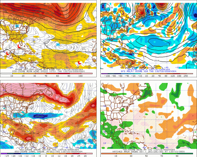
Hi Luis, yes nice catch. :) Actually the GFS shows this coming off the coast Tuesday morning as a strong low but then dissipates it a day or two later ( by Wednesday evening it's gone but a new one is coming off the African coast.) Here's the Tuesday morning and Wednesday evening tropical GFS forecasts.

Btw, I believe that second, somewhat smaller wave behind this one (all the way to the right on your previous sat image above) is the one that's coming off the coast on Wednesday/Thursday. The GFS keeps that one through next weekend as a strong possibility.

The upper right are near-surface vorticity (925 mb). Look there for closed circulation contours and brown or red areas indicate higher vorticity.
lower right is 700 to 500mb mb RH (mid-level RH). lower left is shear. upper left is steering winds.

Tuesday morning - coming off the coast:
Image

Wednesday evening - gone, but a new wave is coming:
Image
0 likes   

User avatar
SFLcane
S2K Supporter
S2K Supporter
Posts: 10163
Age: 47
Joined: Sat Jun 05, 2010 1:44 pm
Location: Lake Worth Florida

Re: Pouch PO9L inside Africa

#5 Postby SFLcane » Sun Jul 14, 2013 7:46 pm

Here is the TW coming into the picture luis..would prefer for it to be a little futher south but well see what happens.

Image
0 likes   

User avatar
cycloneye
Admin
Admin
Posts: 145365
Age: 68
Joined: Thu Oct 10, 2002 10:54 am
Location: San Juan, Puerto Rico

Re: Pouch PO9L inside Africa

#6 Postby cycloneye » Sun Jul 14, 2013 8:00 pm

SFLcane wrote:Here is the TW coming into the picture luis..would prefer for it to be a little futher south but well see what happens.

http://rammb.cira.colostate.edu/ramsdis ... loater.gif


Agree is a little bit north but you never know if this cranks up downstream. The cooling of Gulf of Guinea may be already causing waves to emerge north of 10N latitude.
0 likes   
Visit the Caribbean-Central America Weather Thread where you can find at first post web cams,radars
and observations from Caribbean basin members Click Here

User avatar
Gustywind
Category 5
Category 5
Posts: 12334
Joined: Mon Sep 03, 2007 7:29 am
Location: Baie-Mahault, GUADELOUPE

#7 Postby Gustywind » Sun Jul 14, 2013 8:06 pm

Anyway, that should be very interresting to see how these twaves try to develop or not :)
0 likes   

ozonepete
Professional-Met
Professional-Met
Posts: 4743
Joined: Mon Sep 07, 2009 3:23 pm
Location: From Ozone Park, NYC / Now in Brooklyn, NY

Re: Pouch PO9L inside Africa

#8 Postby ozonepete » Sun Jul 14, 2013 8:34 pm

cycloneye wrote:
SFLcane wrote:Here is the TW coming into the picture luis..would prefer for it to be a little futher south but well see what happens.

http://rammb.cira.colostate.edu/ramsdis ... loater.gif


Agree is a little bit north but you never know if this cranks up downstream. The cooling of Gulf of Guinea may be already causing waves to emerge north of 10N latitude.


Remember that they usually drop southward a few degrees as they come off of the African coast...
0 likes   

User avatar
cycloneye
Admin
Admin
Posts: 145365
Age: 68
Joined: Thu Oct 10, 2002 10:54 am
Location: San Juan, Puerto Rico

Re: Pouch PO9L inside Africa

#9 Postby cycloneye » Mon Jul 15, 2013 8:23 am

Convection has gone down a bit this morning but the wave axis is still far from the coast.Let's see what happens if this pouch bites the dust or stays viable.

Image
0 likes   
Visit the Caribbean-Central America Weather Thread where you can find at first post web cams,radars
and observations from Caribbean basin members Click Here

User avatar
cycloneye
Admin
Admin
Posts: 145365
Age: 68
Joined: Thu Oct 10, 2002 10:54 am
Location: San Juan, Puerto Rico

Re: Pouch PO9L off African Coast

#10 Postby cycloneye » Tue Jul 16, 2013 8:33 am

Well, this pouch has reached this morning the water off the African coast. Sometime today TAFB will introduce it as a Tropical Wave. Here is the latest update by the pouch group.

Image

Image

http://www.met.nps.edu/~mtmontgo/storms2013/P09L.html
0 likes   
Visit the Caribbean-Central America Weather Thread where you can find at first post web cams,radars
and observations from Caribbean basin members Click Here

User avatar
cycloneye
Admin
Admin
Posts: 145365
Age: 68
Joined: Thu Oct 10, 2002 10:54 am
Location: San Juan, Puerto Rico

Re: Pouch PO9L off African Coast

#11 Postby cycloneye » Tue Jul 16, 2013 4:05 pm

Is now a Tropical Wave at 18z surface analysis. This is not the wave the GFS develops.

Image
0 likes   
Visit the Caribbean-Central America Weather Thread where you can find at first post web cams,radars
and observations from Caribbean basin members Click Here

User avatar
cycloneye
Admin
Admin
Posts: 145365
Age: 68
Joined: Thu Oct 10, 2002 10:54 am
Location: San Juan, Puerto Rico

Re: Tropical Wave SE of CV islands (Pouch PO9L)

#12 Postby cycloneye » Tue Jul 16, 2013 6:46 pm

8 PM EDT discussion.

TROPICAL WAVE EXTENDS FROM 17N18W TO 4N18W MOVING WEST AT 15-20
KT. UPPER AIR SOUNDINGS FROM DAKAR SENEGAL INDICATE THE WAVE
MOVING OFF THE COAST OF AFRICA BETWEEN 16/0000 AND 16/1200 UTC.
THE WAVE ALSO COINCIDES WITH A 700 MB TROUGH AXIS AND A SURGE OF
MOISTURE PRESENT IN TOTAL PRECIPITABLE WATER IMAGERY. SCATTERED
MODERATE/STRONG CONVECTION IS FROM 6N-9N BETWEEN 17W-20W.
0 likes   
Visit the Caribbean-Central America Weather Thread where you can find at first post web cams,radars
and observations from Caribbean basin members Click Here

User avatar
cycloneye
Admin
Admin
Posts: 145365
Age: 68
Joined: Thu Oct 10, 2002 10:54 am
Location: San Juan, Puerto Rico

Re: Tropical Wave South of CV Islands (Pouch PO9L)

#13 Postby cycloneye » Wed Jul 17, 2013 7:04 am

8 AM TWD.

AN ATLANTIC OCEAN TROPICAL WAVE IS ALONG 22W/23W TO THE SOUTH OF
20N...MOVING WESTWARD 15 TO 20 KNOTS. CONVECTIVE
PRECIPITATION...SCATTERED TO NUMEROUS STRONG FROM 7N TO 11N
BETWEEN 22W AND 26W IN THE ITCZ.
0 likes   
Visit the Caribbean-Central America Weather Thread where you can find at first post web cams,radars
and observations from Caribbean basin members Click Here

KBBOCA
S2K Supporter
S2K Supporter
Posts: 1559
Joined: Fri Sep 05, 2003 5:27 am
Location: Formerly Boca Raton, often West Africa. Currently Charlotte NC

#14 Postby KBBOCA » Wed Jul 17, 2013 8:34 am

I'm based in Nouakchott, Mauritania (18-06N 015-57W). We just had a massive dust storm come through this morning. I've not seen a storm of this potency here in a number of years. We also had a moderate thunderstorm, winds gusting up to 50MPH.

You can see obs here:
http://www.wunderground.com/global/stations/61442.html

http://www.wunderground.com/history/air ... atename=NA

I'm wondering if large amounts of dust sent out into the Atlantic from this storm might disrupt the next few waves coming off the coast?
0 likes   

User avatar
abajan
S2K Supporter
S2K Supporter
Posts: 4234
Joined: Sun Sep 07, 2003 5:10 am
Location: Barbados

Re:

#15 Postby abajan » Wed Jul 17, 2013 8:45 am

KBBOCA wrote:... I'm wondering if large amounts of dust sent out into the Atlantic from this storm might disrupt the next few waves coming off the coast?
IMO perhaps not because that's a fairly high latitude. Thanks for sharing your personal observation of weather conditions there though.
0 likes   

User avatar
beoumont
Category 1
Category 1
Posts: 473
Joined: Sun Jul 10, 2011 4:13 pm
Location: East Central Florida
Contact:

Re:

#16 Postby beoumont » Wed Jul 17, 2013 9:54 am

KBBOCA wrote:I'm based in Nouakchott, Mauritania (18-06N 015-57W). We just had a massive dust storm come through this morning. I've not seen a storm of this potency here in a number of years. We also had a moderate thunderstorm, winds gusting up to 50MPH.


Now, that's "mud in your eyes". Literally.
0 likes   
List of 79 tropical cyclones intercepted by Richard Horodner:
http://www.canebeard.com/page/page/572246.htm

User avatar
AJC3
Admin
Admin
Posts: 3999
Age: 61
Joined: Tue Aug 31, 2004 7:04 pm
Location: Ballston Spa, New York
Contact:

Re:

#17 Postby AJC3 » Wed Jul 17, 2013 3:32 pm

KBBOCA wrote:I'm based in Nouakchott, Mauritania (18-06N 015-57W). We just had a massive dust storm come through this morning. I've not seen a storm of this potency here in a number of years. We also had a moderate thunderstorm, winds gusting up to 50MPH.

You can see obs here:
http://www.wunderground.com/global/stations/61442.html

http://www.wunderground.com/history/air ... atename=NA

I'm wondering if large amounts of dust sent out into the Atlantic from this storm might disrupt the next few waves coming off the coast?


That city/area (and the whole country for that matter) look pretty harsh. How were you "lucky" enough to get that gig?
0 likes   

RL3AO
Moderator-Pro Met
Moderator-Pro Met
Posts: 16308
Joined: Thu Jun 14, 2007 10:03 pm
Location: NC

#18 Postby RL3AO » Wed Jul 17, 2013 3:53 pm

So far the environment looks pretty good off the coast. You are getting the standard dry air between the waves, but overall it looks pretty good for these waves come August...if the trade winds slow down.

http://tropic.ssec.wisc.edu/real-time/m ... t72hrs.gif
0 likes   

User avatar
cycloneye
Admin
Admin
Posts: 145365
Age: 68
Joined: Thu Oct 10, 2002 10:54 am
Location: San Juan, Puerto Rico

Re: Tropical Wave SW of CV Islands (Pouch PO9L)

#19 Postby cycloneye » Wed Jul 17, 2013 6:52 pm

8 PM EDT discussion.

TROPICAL WAVE EXTENDS FROM 19N25W TO 8N29W MOVING W AT 15-20 KT.
THE WAVE COINCIDES WITH A LARGE SURGE OF DEEP LAYER MOISTURE
PRESENT IN TOTAL PRECIPITABLE WATER IMAGERY ALONG WITH A 700 MB
TROUGH AXIS. SCATTERED MODERATE/ISOLATED STRONG CONVECTION IS
FROM 7N-10N BETWEEN 25W-33W.
0 likes   
Visit the Caribbean-Central America Weather Thread where you can find at first post web cams,radars
and observations from Caribbean basin members Click Here

User avatar
cycloneye
Admin
Admin
Posts: 145365
Age: 68
Joined: Thu Oct 10, 2002 10:54 am
Location: San Juan, Puerto Rico

Re: Tropical Wave in EastCentral Atlantic (Pouch PO9L)

#20 Postby cycloneye » Thu Jul 18, 2013 6:51 pm

8 PM discussion.

TROPICAL WAVE EXTENDS FROM 22N33W TO 10N35W MOVING WEST AT 15-20
KT. THE WAVE LIES WITHIN A LARGE SURGE OF MOISTURE EVIDENT IN
TOTAL PRECIPITABLE WATER IMAGERY. A 700 MB TROUGH AXIS ALSO
ALIGNS WELL WITH THE WAVE AXIS. DUE TO THE PRESENCE OF A SAHARAN
AIR LAYER SURROUNDING THE WAVE...NO DEEP CONVECTION IS
CURRENTLY ASSOCIATED WITH THE AXIS.
0 likes   
Visit the Caribbean-Central America Weather Thread where you can find at first post web cams,radars
and observations from Caribbean basin members Click Here


Return to “Talkin' Tropics”

Who is online

Users browsing this forum: cheezyWXguy, Google Adsense [Bot], riapal, TampaWxLurker and 37 guests