West PAC - disturbance near 140E (Is Invest 96W)

This is the general tropical discussion area. Anyone can take their shot at predicting a storms path.

Moderator: S2k Moderators

Forum rules

The posts in this forum are NOT official forecasts and should not be used as such. They are just the opinion of the poster and may or may not be backed by sound meteorological data. They are NOT endorsed by any professional institution or STORM2K. For official information, please refer to products from the National Hurricane Center and National Weather Service.

Help Support Storm2K
Message
Author
RL3AO
Moderator-Pro Met
Moderator-Pro Met
Posts: 16308
Joined: Thu Jun 14, 2007 10:03 pm
Location: NC

West PAC - disturbance near 140E (Is Invest 96W)

#1 Postby RL3AO » Thu Aug 01, 2013 10:54 am

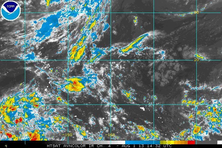
Lots of model support on this one. GFS/Euro/GEM all develop what appears to be a strong typhoon approaching Asia in 10 days.

Looks like its connected to the area approaching the anti-meridian on the right side of the image.
Image
0 likes   

User avatar
'CaneFreak
Category 5
Category 5
Posts: 1486
Joined: Mon Jun 05, 2006 10:50 am
Location: New Bern, NC

Re: West Pacific - Models show strong typhoon next week

#2 Postby 'CaneFreak » Thu Aug 01, 2013 11:03 am

Yeah...this one looks interesting...looks to take the same track as the others too - across Luzon and then into the South China Sea. Given that ridge seems to be holding pretty firm across Taiwan and eastern China, it would at least seem that Hong Kong would be spared any significant impacts.
0 likes   

dexterlabio
Category 5
Category 5
Posts: 3468
Joined: Sat Oct 24, 2009 11:50 pm

Re: West Pacific - Models show strong typhoon next week

#3 Postby dexterlabio » Thu Aug 01, 2013 12:10 pm

I'm glad that ATL season followers also follow this other side of the world. :lol:

This one is interesting indeed, given that GFS has been showing a strong typhoon in the long range and it's been doing so for several runs now. The previous GFS model runs hint landfall in Taiwan. I'm not sure though if Luzon has a chance to be affected if ever..the latest 12z run seems to depict a stronger STR which leads to the system making its way towards S. China. Of course this is all long range talk. :lol: Besides, there is a potential TC even before this one that threatens the Central Philippines so we have to put our attention on that first. I'm currently in Manila, by the way. :lol:
0 likes   
Personal Forecast Disclaimer:
The posts in this forum are NOT official forecast and should not be used as such. They are just the opinion of the poster and may or may not be backed by sound meteorological data. They are NOT endorsed by any professional institution or storm2k.org. For official information, please refer to the NHC and NWS products.

Typhoon Hunter
WesternPacificWeather.com
Posts: 1221
Joined: Wed Oct 11, 2006 11:37 am
Location: Tokyo
Contact:

Re: West Pacific - Models show strong typhoon next week

#4 Postby Typhoon Hunter » Thu Aug 01, 2013 7:50 pm

'CaneFreak wrote:Yeah...this one looks interesting...looks to take the same track as the others too - across Luzon and then into the South China Sea. Given that ridge seems to be holding pretty firm across Taiwan and eastern China, it would at least seem that Hong Kong would be spared any significant impacts.


Are you referring to 94W? That's forecast to form in the next 48 -72 hours and potentially follow a similar path to Jebi. The storm mentioned in the opening thread is way off in the long range but the models have been very consistent in spinning it up. Anywhere between Okinawa and Luzon maybe need to keep an eye on this down the line since models depicting a firm ridge in place.

18Z follows 12z Dexter, another impact / close shave with northern Luzon. Whatever happens this "storm" is interesting to track in the models, almost feels like it's real! :D
0 likes   
James - Documenting tropical cyclones...

http://www.youtube.com/TyphoonHunter

dexterlabio
Category 5
Category 5
Posts: 3468
Joined: Sat Oct 24, 2009 11:50 pm

Re: West Pacific - Models show strong typhoon next week

#5 Postby dexterlabio » Fri Aug 02, 2013 12:42 am

Typhoon Hunter wrote:18Z follows 12z Dexter, another impact / close shave with northern Luzon. Whatever happens this "storm" is interesting to track in the models, almost feels like it's real! :D


Make it three times in a row. 00z shows this one making an impact in Northern Luzon then going towards Southern China, maybe close to HK. Still showing a stronger west pacific high. But this time around it seems like it's taking time to intensify unlike in the previous runs.

Yes I agree, it feels like it's already there. :lol:
0 likes   
Personal Forecast Disclaimer:
The posts in this forum are NOT official forecast and should not be used as such. They are just the opinion of the poster and may or may not be backed by sound meteorological data. They are NOT endorsed by any professional institution or storm2k.org. For official information, please refer to the NHC and NWS products.

Alyono
Professional-Met
Professional-Met
Posts: 6961
Joined: Fri Apr 26, 2013 3:52 pm
Location: Texas Coast

#6 Postby Alyono » Fri Aug 02, 2013 5:47 pm

GFS totally dropped the typhoon
0 likes   

RL3AO
Moderator-Pro Met
Moderator-Pro Met
Posts: 16308
Joined: Thu Jun 14, 2007 10:03 pm
Location: NC

#7 Postby RL3AO » Fri Aug 02, 2013 5:50 pm

Yep. Seven or eight straight runs and now no where to be seen.
0 likes   

dexterlabio
Category 5
Category 5
Posts: 3468
Joined: Sat Oct 24, 2009 11:50 pm

Re: West Pacific - Models show strong typhoon next week

#8 Postby dexterlabio » Fri Aug 02, 2013 8:29 pm

it's actually up on 18z run...but a weaker system instead of a strong typhoon... Euro also shows a weak system out of this.
0 likes   
Personal Forecast Disclaimer:
The posts in this forum are NOT official forecast and should not be used as such. They are just the opinion of the poster and may or may not be backed by sound meteorological data. They are NOT endorsed by any professional institution or storm2k.org. For official information, please refer to the NHC and NWS products.

Typhoon Hunter
WesternPacificWeather.com
Posts: 1221
Joined: Wed Oct 11, 2006 11:37 am
Location: Tokyo
Contact:

Re: West Pacific - Models show strong typhoon next week

#9 Postby Typhoon Hunter » Fri Aug 02, 2013 8:57 pm

Big backtrack from GFS there. Wpac ACE really suffering this season, where are the typhoons?!
0 likes   
James - Documenting tropical cyclones...

http://www.youtube.com/TyphoonHunter

dexterlabio
Category 5
Category 5
Posts: 3468
Joined: Sat Oct 24, 2009 11:50 pm

Re: West Pacific - Models show strong typhoon next week

#10 Postby dexterlabio » Fri Aug 02, 2013 10:34 pm

It feels like La Nina condition is present...strong ridge of high pressure dominating across the Pacific, westward movement of systems and towards SCS, limited area of development of tropical cyclones.. I'm not sure how many typhoons will appear in the future but take note that even those years with strong La Nina present had intense typhoons. There might only be a few of them forming, but these few could be the ones we should keep an eye on..like in 1998 and 2010.
0 likes   
Personal Forecast Disclaimer:
The posts in this forum are NOT official forecast and should not be used as such. They are just the opinion of the poster and may or may not be backed by sound meteorological data. They are NOT endorsed by any professional institution or storm2k.org. For official information, please refer to the NHC and NWS products.

euro6208

Re: West Pacific - Models show strong typhoon next week

#11 Postby euro6208 » Fri Aug 02, 2013 11:57 pm

Come on Typhoons!
0 likes   

dexterlabio
Category 5
Category 5
Posts: 3468
Joined: Sat Oct 24, 2009 11:50 pm

Re: West Pacific - Models show strong typhoon next week

#12 Postby dexterlabio » Sat Aug 03, 2013 12:01 am

and the latest GFS run says nada. :lol: oh well, I'm feeling the 2010 vibes right now.
0 likes   
Personal Forecast Disclaimer:
The posts in this forum are NOT official forecast and should not be used as such. They are just the opinion of the poster and may or may not be backed by sound meteorological data. They are NOT endorsed by any professional institution or storm2k.org. For official information, please refer to the NHC and NWS products.

vrif
Category 1
Category 1
Posts: 282
Joined: Sun Jun 09, 2013 10:51 pm

#13 Postby vrif » Sun Aug 04, 2013 3:00 am

The latest 0Z EC and GFS runs are detecting the storm again from forecast hour 144 onwards. I wonder if it will stay in the future runs.
0 likes   

User avatar
alan1961
Category 2
Category 2
Posts: 771
Joined: Mon Mar 20, 2006 11:58 am
Location: Derby, Derbyshire, England
Contact:

Re: West Pacific - Models show strong typhoon next week

#14 Postby alan1961 » Sun Aug 04, 2013 11:02 am

Latest GFS 12z run develops a storm around Luzon around a week
from now

Image

and develops another one around the same time that goes crashing
into southern japan at the end of the run.

Image
0 likes   

RL3AO
Moderator-Pro Met
Moderator-Pro Met
Posts: 16308
Joined: Thu Jun 14, 2007 10:03 pm
Location: NC

#15 Postby RL3AO » Sun Aug 04, 2013 1:21 pm

12z GFS back with a vengeance. Strongest it has had it yet, showing a 958mb system east of Luzon.
0 likes   

RL3AO
Moderator-Pro Met
Moderator-Pro Met
Posts: 16308
Joined: Thu Jun 14, 2007 10:03 pm
Location: NC

#16 Postby RL3AO » Sun Aug 04, 2013 1:27 pm

12z CMC develops a monster storm. When east of Okinawa, it shows 40kt winds at 900mb stretching from 127E to 145E (thats 1000 miles give or take).
0 likes   

Typhoon Hunter
WesternPacificWeather.com
Posts: 1221
Joined: Wed Oct 11, 2006 11:37 am
Location: Tokyo
Contact:

Re: West Pacific - Models show strong typhoon next week

#17 Postby Typhoon Hunter » Sun Aug 04, 2013 8:04 pm

GFS certainly back on the development bandwagon with this system. 18Z run shows a feature appear south of Guam around 4-5 day mark which is what I'd call the near to medium term. I'm starting to think the odds of development are looking better given the time frame, let's see if persistence holds.

CMC 12z was a weird run, showed two TCs merging together and forming a monster, I don't buy that!

I highly recommend Levi Cowen's webpage for the models. Really nice graphics for GFS, NAVGEM and CMC - http://www.tropicaltidbits.com/analysis/models/
0 likes   
James - Documenting tropical cyclones...

http://www.youtube.com/TyphoonHunter

dexterlabio
Category 5
Category 5
Posts: 3468
Joined: Sat Oct 24, 2009 11:50 pm

Re: West Pacific - Models show strong typhoon next week

#18 Postby dexterlabio » Mon Aug 05, 2013 12:13 am

GFS 00z still shows this system but looks to have weakened before the 13th, then the next time frames show an intense typhoon tracking towards Taiwan up to the 18th. So basically that was another system isn't it? not the same system it's been showing to form later this week near Guam?

By the way, it may not be obvious but Euro 12z is also showing development of a weak low pressure system near Luzon sometime between 10-12 of August.
Last edited by dexterlabio on Mon Aug 05, 2013 5:34 am, edited 1 time in total.
0 likes   
Personal Forecast Disclaimer:
The posts in this forum are NOT official forecast and should not be used as such. They are just the opinion of the poster and may or may not be backed by sound meteorological data. They are NOT endorsed by any professional institution or storm2k.org. For official information, please refer to the NHC and NWS products.

vrif
Category 1
Category 1
Posts: 282
Joined: Sun Jun 09, 2013 10:51 pm

Re: West Pacific - Models show strong typhoon next week

#19 Postby vrif » Mon Aug 05, 2013 2:19 am

dexterlabio wrote:GFS 00z still shows this system but looks to have weakened before the 13th, then the next time frames show an intense typhoon tracking towards Taiwan up to the 21st. So basically that was another system isn't it? not the same system it's been showing to form later this week near Guam?

By the way, it may not be obvious but Euro 12z is also showing development of a weak low pressure system near Luzon sometime between 10-12 of August.


I think it may be the same system. The strong typhoon was shown on the August 1st 0Z run +240hr forecast, which would correspond to August 5th 0Z +120hr or +144hr.

The current 0Z +120 hr (Aug 10 0Z) forecast is indicating a weak low pressure region east of the Philippines from all the models. Even +72hr is showing this region further out east.
0 likes   

Typhoon Hunter
WesternPacificWeather.com
Posts: 1221
Joined: Wed Oct 11, 2006 11:37 am
Location: Tokyo
Contact:

Re: West Pacific - Models show strong typhoon next week

#20 Postby Typhoon Hunter » Mon Aug 05, 2013 2:25 am

Hmmm odd GFS 00z run, basically killed off the storm again and does very weird things with a storm out at 300hrs+. Wouldn't be surprised to see our "Utor" back again in 06z runs!
0 likes   
James - Documenting tropical cyclones...

http://www.youtube.com/TyphoonHunter


Return to “Talkin' Tropics”

Who is online

Users browsing this forum: Google Adsense [Bot] and 21 guests