Central Caribbean Wave (Gulf Development?) (Is Invest 92L)

This is the general tropical discussion area. Anyone can take their shot at predicting a storms path.

Moderator: S2k Moderators

Forum rules

The posts in this forum are NOT official forecasts and should not be used as such. They are just the opinion of the poster and may or may not be backed by sound meteorological data. They are NOT endorsed by any professional institution or STORM2K. For official information, please refer to products from the National Hurricane Center and National Weather Service.

Help Support Storm2K

Will this system become a tropical cyclone?

Poll ended at Wed Aug 14, 2013 6:28 pm

Yes - on Wednesday
1
1%
Yes - on Thursday
27
26%
Yes - on Friday
41
40%
Yes - on Saturday or later
17
17%
No - it will not develop
17
17%
 
Total votes: 103

Message
Author
User avatar
ROCK
Category 5
Category 5
Posts: 9484
Age: 54
Joined: Tue Aug 17, 2004 7:30 am
Location: Kemah, Texas

Re: Global Model Runs Discussion

#41 Postby ROCK » Sat Aug 10, 2013 7:50 pm

perk wrote:
ROCK wrote:https://www.fnmoc.navy.mil/wxmap_cgi/cgi-bin/wxmap_loop.cgi?area=nvg_troplant&dtg=2013081018&prod=sfc10m&tau=000&set=Tropical

18Z NAVGEM still has it...this time a little further north after crossing the Yucatan.


I guest we should start watching the western carribean around Tuesday or Wednesday for the initial stage of development.


I will be... :wink:
0 likes   

User avatar
Rgv20
S2K Supporter
S2K Supporter
Posts: 2466
Age: 38
Joined: Wed Jan 05, 2011 5:42 pm
Location: Edinburg/McAllen Tx

#42 Postby Rgv20 » Sat Aug 10, 2013 11:30 pm

Looks like the 0zGFS is back to the idea of a Disturbance in the BOC come next weekend..

Image

Uploaded with ImageShack.us
0 likes   
The following post is NOT an official forecast and should not be used as such. It is just the opinion of the poster and may or may not be backed by sound meteorological data. It is NOT endorsed by any professional institution including storm2k.org For Official Information please refer to the NHC and NWS products.

User avatar
ROCK
Category 5
Category 5
Posts: 9484
Age: 54
Joined: Tue Aug 17, 2004 7:30 am
Location: Kemah, Texas

Re: Any thoughts on chances of homegrown in the Gulf next week?

#43 Postby ROCK » Sat Aug 10, 2013 11:57 pm

0Z NAVGEM still has it....not finished with the run yet....will post when done...
0 likes   

User avatar
Rgv20
S2K Supporter
S2K Supporter
Posts: 2466
Age: 38
Joined: Wed Jan 05, 2011 5:42 pm
Location: Edinburg/McAllen Tx

#44 Postby Rgv20 » Sun Aug 11, 2013 12:18 am

0zNAVGEM and 0zCMC still showing the GOM system....In my opinion the CMC is way to fast with the speed and development of this disturbance as it has it as a 999mb low by Saturday Morning.

0zNAVGE forecast for Sunday Morning.
Image

Uploaded with ImageShack.us


0zCMC forecast for Saturday Morning.
Image

Uploaded with ImageShack.us
0 likes   
The following post is NOT an official forecast and should not be used as such. It is just the opinion of the poster and may or may not be backed by sound meteorological data. It is NOT endorsed by any professional institution including storm2k.org For Official Information please refer to the NHC and NWS products.

User avatar
cycloneye
Admin
Admin
Posts: 145299
Age: 68
Joined: Thu Oct 10, 2002 10:54 am
Location: San Juan, Puerto Rico

Re: Any thoughts on chances of homegrown in the Gulf?

#45 Postby cycloneye » Sun Aug 11, 2013 6:40 am

No mention yet.

TROPICAL WEATHER OUTLOOK
NWS NATIONAL HURRICANE CENTER MIAMI FL
800 AM EDT SUN AUG 11 2013

FOR THE NORTH ATLANTIC...CARIBBEAN SEA AND THE GULF OF MEXICO...

TROPICAL CYCLONE FORMATION IS NOT EXPECTED DURING THE NEXT FIVE
DAYS.

&&

FIVE-DAY FORMATION PROBABILITIES ARE EXPERIMENTAL IN 2013. COMMENTS
ON THE EXPERIMENTAL FORECASTS CAN BE PROVIDED AT...

HTTP://WWW.NWS.NOAA.GOV/SURVEY/NWS-SURVEY.PHP?CODE=ETWO

$$
FORECASTER BROWN
0 likes   
Visit the Caribbean-Central America Weather Thread where you can find at first post web cams,radars
and observations from Caribbean basin members Click Here

User avatar
cycloneye
Admin
Admin
Posts: 145299
Age: 68
Joined: Thu Oct 10, 2002 10:54 am
Location: San Juan, Puerto Rico

Re: Any thoughts on chances of homegrown in the Gulf?

#46 Postby cycloneye » Sun Aug 11, 2013 7:00 am

This is what Dr Jeff Masters said this morning about this.

Some of the models are suggesting a strong tropical disturbance capable of becoming a tropical storm could form by Saturday in the Gulf of Mexico near Mexico's Yucatan Peninsula, in association with a stalled cold front expected to push off the Southeast U.S. coast late this week.
0 likes   
Visit the Caribbean-Central America Weather Thread where you can find at first post web cams,radars
and observations from Caribbean basin members Click Here

User avatar
ronjon
Category 5
Category 5
Posts: 4822
Joined: Fri Aug 19, 2005 5:17 pm
Location: Hernando Beach, FL

Re: Any thoughts on chances of homegrown in the Gulf?

#47 Postby ronjon » Sun Aug 11, 2013 7:04 am

I see that the 06z NAVGEM bounced back eastward now more in line with the 00z CMC with a FL panhandle LF. Meanwhile, the GFS wants to bury this feature in the BOC. The 00z Euro shows a pretty sharp trough digging down over La next weekend so if that 500 mb pattern develops, it looks like a more eastward path of this disturbance toward the central or east-central gulf coast.

http://www.ecmwf.int/products/forecasts/d/charts/medium/deterministic/msl_uv850_z500!Geopotential%20500%20hPa%20and%20Temperature%20at%20850%20hPa!168!North%20America!pop!od!oper!public_plots!2013081100!!/
0 likes   

User avatar
NDG
S2K Supporter
S2K Supporter
Posts: 15446
Joined: Sun Jul 09, 2006 10:14 pm
Location: Orlando, FL

Re: Any thoughts on chances of homegrown in the Gulf?

#48 Postby NDG » Sun Aug 11, 2013 7:45 am

I think chances of a homegrown tropical system in the western Caribbean/southern GOM are growing.
With a trough digging down across the GL and then across the MS river valley it should push the persistent death ridge west towards the SW US, this in turn should make for an UL ridge position across the NW Caribbean and southern GOM by late next week, creating better UL conditions that have not been seen in this area in weeks.
Even the euro shows lowering pressures and disturbed weather in the central Caribbean through the next 3 days but after that it looses it and or broadens it up.
The GFS solution of a weak and track into the southern BOC of the potential system is somewhat suspicious with such a deep trough digging down across the MS river valley next week, IMO.

This post is NOT AN OFFICIAL FORECAST and should not be used as such. It is just the opinion of the poster and may or may not be backed by sound meteorological data. It is NOT endorsed by any professional institution including storm2k.org. For Official Information please refer to the NHC and NWS products.
0 likes   

User avatar
northjaxpro
S2K Supporter
S2K Supporter
Posts: 8900
Joined: Mon Sep 27, 2010 11:21 am
Location: Jacksonville, FL

#49 Postby northjaxpro » Sun Aug 11, 2013 8:06 am

:uarrow:Yes, I also believe that conditions should be more favorable for development next week in the GOM.

The key is that the death ride over Texas finally does break down. How much does the developing trough next week amplify is the huge factor if we get something to develop next week somewhere across the southern GOM/BOC.
0 likes   
NEVER, EVER SAY NEVER in the tropics and weather in general, and most importantly, with life itself!!

________________________________________________________________________________________

Fay 2008 Beryl 2012 Debby 2012 Colin 2016 Hermine 2016 Julia 2016 Matthew 2016 Irma 2017 Dorian 2019

CYCLONE MIKE
Category 5
Category 5
Posts: 2183
Joined: Tue Aug 31, 2004 6:04 pm
Location: Gonzales, LA

Re: Any thoughts on chances of homegrown in the Gulf?

#50 Postby CYCLONE MIKE » Sun Aug 11, 2013 8:37 am

Here is a piece of this mornings long term forecast discussion from our local nws which will help with where this phantom storm might go IF it were to develop :lol:

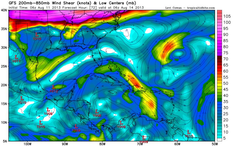
Dont know how good conditions will be towards end of next week. Sounds like there could be a lot if shear to contend with as well. Anybody have a 5-7 day shear forecast map? Might be one our famous sheared gulf messes.

LONG TERM...MEDIUM RANGE MDLS CONTINUE TO REMAIN IN GENERAL
AGREEMENT WITH AN ACTIVE PATTERN SETTING UP. THE PATTERN SHIFT WILL
HAVE ALREADY OCCURRED BY WED AND ONCE AGAIN WE LOOK TO MOVE INTO A
DEEP ERN CONUS TROUGH WHICH HAD DOMINATED MUCH OF THE SUMMER UNTIL
RECENTLY.

HEADING INTO WED AND THE BACK HALF OF THE WORK WEEK RAIN CHANCES
WILL CONTINUE TO BE RATHER HIGH. THE BNDRY THAT HAS REMAINED WELL
OFF TO OUR NORTH THAT WAS ASSOCIATED WITH NORTH ARKANSAS FLOODING
RAIN WILL GET A SURGE TO THE SOUTH UNDER NW FLOW WITH THE TROUGH
DEEPENING OVER THE ERN CONUS. THE FRONT WILL ARRIVE INTO THE CWA THU
AND FRI AND SHOULD CONTINUE TO SLOWLY WINK TO THE SOUTH. THIS WILL
LEAD TO ABV NORMAL RAIN CHANCES ALONG WITH SLIGHTLY BELOW NORMAL
TEMPS. HAVE CONTINUED THE TREND TO INCREASE POPS IN THE EXTENDED AND
WILL SHOW 40-60% THROUGH THE END OF THE WORK WEEK.
Last edited by CYCLONE MIKE on Sun Aug 11, 2013 8:53 am, edited 1 time in total.
0 likes   

HurricaneDREW92
Category 1
Category 1
Posts: 320
Age: 26
Joined: Sun Jul 28, 2013 11:56 am
Location: Boston, MA

Re: Any thoughts on chances of homegrown in the Gulf?

#51 Postby HurricaneDREW92 » Sun Aug 11, 2013 8:47 am

Can anybody post a current satellite image of the system they are developing??
0 likes   
This post is NOT AN OFFICIAL FORECAST and should not be used as such. It is just the opinion of the poster and may or may not be backed by sound meteorological data. It is NOT endorsed by any professional institution including storm2k.org. For Official Information please refer to the NHC and NWS products.

-THE ABOVE IS THE OPINION OF DREW ONLY

Sanibel
Category 5
Category 5
Posts: 10375
Joined: Mon Aug 30, 2004 11:06 pm
Location: Offshore SW Florida

Re: Any thoughts on chances of homegrown in the Gulf?

#52 Postby Sanibel » Sun Aug 11, 2013 8:52 am

Don't see it. The season is unexpectedly negative. It should change by the peak however this could be the sign of a downturn in the MDO.
0 likes   

User avatar
wxman57
Moderator-Pro Met
Moderator-Pro Met
Posts: 22978
Age: 67
Joined: Sat Jun 21, 2003 8:06 pm
Location: Houston, TX (southwest)

Re: Any thoughts on chances of homegrown in the Gulf?

#53 Postby wxman57 » Sun Aug 11, 2013 9:00 am

I'm tracking down the feature that the models are developing later this week and it seems to be the wave in the eastern Caribbean (Pouch #16). Development may occur as early as Thursday/Friday, which is well within the NHC's 5-day outlook.
0 likes   

User avatar
NDG
S2K Supporter
S2K Supporter
Posts: 15446
Joined: Sun Jul 09, 2006 10:14 pm
Location: Orlando, FL

Re: Any thoughts on chances of homegrown in the Gulf?

#54 Postby NDG » Sun Aug 11, 2013 9:02 am

HurricaneDREW92 wrote:Can anybody post a current satellite image of the system they are developing??


Is the tropical wave entering the extreme eastern Caribbean/northern S.A.

Image
0 likes   

User avatar
NDG
S2K Supporter
S2K Supporter
Posts: 15446
Joined: Sun Jul 09, 2006 10:14 pm
Location: Orlando, FL

#55 Postby NDG » Sun Aug 11, 2013 9:06 am

GFS shows UL ridge to start building in the central Caribbean as early as Tuesday night/Wednesday morning.

Image
0 likes   

CYCLONE MIKE
Category 5
Category 5
Posts: 2183
Joined: Tue Aug 31, 2004 6:04 pm
Location: Gonzales, LA

Re: Any thoughts on chances of homegrown in the Gulf?

#56 Postby CYCLONE MIKE » Sun Aug 11, 2013 9:08 am

wxman57 wrote:I'm tracking down the feature that the models are developing later this week and it seems to be the wave in the eastern Caribbean (Pouch #16). Development may occur as early as Thursday/Friday, which is well within the NHC's 5-day outlook.


Wxman, how do see the conditions in the gulf for that timeframe? Hostile sheared mess, or dont think the front and east coast trough will have much affect?
0 likes   

User avatar
gatorcane
S2K Supporter
S2K Supporter
Posts: 23691
Age: 47
Joined: Sun Mar 13, 2005 3:54 pm
Location: Boca Raton, FL

#57 Postby gatorcane » Sun Aug 11, 2013 9:13 am

There certainly seems like there could be a mid-latitude trough passing through the Southern U.S. later this week into next weekend that could pick this up if the system gets deep enough. But fortunately the GFS keeps the system weak so heads into the BOC then southern Mexico with little to no development.

Here is the 06Z GFS 500MB steering 144 hours from now where you can see the trough digging down to the northern GOM and the system in the BOC:

Image
0 likes   

User avatar
wxman57
Moderator-Pro Met
Moderator-Pro Met
Posts: 22978
Age: 67
Joined: Sat Jun 21, 2003 8:06 pm
Location: Houston, TX (southwest)

Re: Any thoughts on chances of homegrown in the Gulf?

#58 Postby wxman57 » Sun Aug 11, 2013 9:24 am

CYCLONE MIKE wrote:
wxman57 wrote:I'm tracking down the feature that the models are developing later this week and it seems to be the wave in the eastern Caribbean (Pouch #16). Development may occur as early as Thursday/Friday, which is well within the NHC's 5-day outlook.


Wxman, how do see the conditions in the gulf for that timeframe? Hostile sheared mess, or dont think the front and east coast trough will have much affect?


Models are forecasting shear to drop off significantly in the southern Gulf and NW Caribbean by Thursday. Still a bit high in the northern Gulf.
0 likes   

HurricaneDREW92
Category 1
Category 1
Posts: 320
Age: 26
Joined: Sun Jul 28, 2013 11:56 am
Location: Boston, MA

Re: Any thoughts on chances of homegrown in the Gulf?

#59 Postby HurricaneDREW92 » Sun Aug 11, 2013 9:34 am

wxman57 wrote:I'm tracking down the feature that the models are developing later this week and it seems to be the wave in the eastern Caribbean (Pouch #16). Development may occur as early as Thursday/Friday, which is well within the NHC's 5-day outlook.

When, if at all do you think we may see this in a TWO, wxman? Thanks in advance.
0 likes   
This post is NOT AN OFFICIAL FORECAST and should not be used as such. It is just the opinion of the poster and may or may not be backed by sound meteorological data. It is NOT endorsed by any professional institution including storm2k.org. For Official Information please refer to the NHC and NWS products.

-THE ABOVE IS THE OPINION OF DREW ONLY

User avatar
cycloneye
Admin
Admin
Posts: 145299
Age: 68
Joined: Thu Oct 10, 2002 10:54 am
Location: San Juan, Puerto Rico

Re: Any thoughts on chances of homegrown in the Gulf?

#60 Postby cycloneye » Sun Aug 11, 2013 9:36 am

Here is what the pouch group has about P16L. wxman57,there is uncertainty about this pouch.

P16L
13N, 62W
700 hPa

NOTE: Same longitude as in yesterday's examination, which begs the question: Was yesterday's model depiction erroneous, or is this a different/new pouch farther east? My guess is the former. In both models, yesterday's analyses depicted a weak pouch that was difficult to determine an exact location. Today's analyses have a very distinct, circular pouch. I think that perhaps as P16L passed into the vicinity of the additional observations from the Windward Islands, the models were able to more accurately depict the wave/pouch. Then again, the analyses from the last couple days depicted P16L to be on the western edge of a larger circulation to the east. So, there is a bit of uncertainty here, but there is not enough evidence to initiate a brand new pouch.

ECMWF: Distinct pouch in the analysis tracks westward for two days as an OW max on the northern edge of the south Caribbean gyre for most of that time. After 48 hours, it becomes difficult to discern P16L from the larger gyre to the south, which then tracks northwestward (most likely as too large).

GFS: Lasts 12 hours longer than ECMWF as distinguishable from the south Caribbean gyre.

http://www.met.nps.edu/~mtmontgo/storms2013.html

http://www.met.nps.edu/~mtmontgo/storms2013/P16L.html


Image

Image
0 likes   
Visit the Caribbean-Central America Weather Thread where you can find at first post web cams,radars
and observations from Caribbean basin members Click Here


Return to “Talkin' Tropics”

Who is online

Users browsing this forum: No registered users and 29 guests