ATL: INVEST 92L - Discussion

Moderator: S2k Moderators

Message
Author
User avatar
cycloneye
Admin
Admin
Posts: 145309
Age: 68
Joined: Thu Oct 10, 2002 10:54 am
Location: San Juan, Puerto Rico

Re: ATL: INVEST 92L - Discussion

#381 Postby cycloneye » Wed Aug 14, 2013 7:50 pm

hcane27 wrote:
stormhunter7 wrote:any reason why 92L was taking of SSD Floater page? :)


They have it in the Eastern Pacifi :roll: c ....


For some reason is in EPAC section.

http://www.ssd.noaa.gov/PS/TROP/floaters.html
0 likes   
Visit the Caribbean-Central America Weather Thread where you can find at first post web cams,radars
and observations from Caribbean basin members Click Here

User avatar
LaBreeze
Category 5
Category 5
Posts: 1497
Joined: Thu Sep 04, 2003 1:57 pm
Location: SW Louisiana

Re: ATL: INVEST 92L - Discussion

#382 Postby LaBreeze » Wed Aug 14, 2013 7:57 pm

colangie wrote:Im thinking Landfall anywhere between Lousiana to Navarre Florida. Maybe as a CAT 1 ....who knows...waiting game...

Ok :lol: hope thats better!

Personal Forecast Disclaimer:
The posts in this forum are NOT official forecast and should not be used as such. They are just the opinion of the poster and may or may not be backed by sound meteorological data. They are NOT endorsed by any professional institution or storm2k.org. For official information, please refer to the NHC and NWS products.

Are you including the entire Louisiana coast on this or just SE LA?
0 likes   

User avatar
wxman57
Moderator-Pro Met
Moderator-Pro Met
Posts: 22978
Age: 67
Joined: Sat Jun 21, 2003 8:06 pm
Location: Houston, TX (southwest)

Re: ATL: INVEST 92L - Discussion

#383 Postby wxman57 » Wed Aug 14, 2013 8:02 pm

Check out the projected 200mb (upper-level) flow associated with the trof Saturday night when this system may be a bit south of SE LA. If this is even close to right then there's no threat to SW Louisiana. And wind shear may increasing rapidly as it nears the Gulf Coast.

200mb winds:
http://www.tropicaltidbits.com/analysis ... atl_29.png

Shear:
http://www.tropicaltidbits.com/analysis ... atl_29.png
0 likes   

User avatar
ROCK
Category 5
Category 5
Posts: 9484
Age: 54
Joined: Tue Aug 17, 2004 7:30 am
Location: Kemah, Texas

Re: ATL: INVEST 92L - Discussion

#384 Postby ROCK » Wed Aug 14, 2013 8:18 pm

wxman57 wrote:Check out the projected 200mb (upper-level) flow associated with the trof Saturday night when this system may be a bit south of SE LA. If this is even close to right then there's no threat to SW Louisiana. And wind shear may increasing rapidly as it nears the Gulf Coast.

200mb winds:
http://www.tropicaltidbits.com/analysis ... atl_29.png

Shear:
http://www.tropicaltidbits.com/analysis ... atl_29.png


that is IF it takes the NGOM track....if it takes the southern track into the BOC, steering collapses as indicated by the EURO then all bets are off...the NAM has this crawling thru the BOC for a few days until finally moving..... 0Z GFS ensembles are in the BOC...

Image
Last edited by ROCK on Wed Aug 14, 2013 8:24 pm, edited 1 time in total.
0 likes   

ozonepete
Professional-Met
Professional-Met
Posts: 4743
Joined: Mon Sep 07, 2009 3:23 pm
Location: From Ozone Park, NYC / Now in Brooklyn, NY

Re: ATL: INVEST 92L - Discussion

#385 Postby ozonepete » Wed Aug 14, 2013 8:18 pm

wxman57 wrote:00Z tropical models in (ignore BAMs). Good concentration toward SE LA/MS/AL. Only the old NGP (NOGAPS) and Canadian take it west. Good sign, as I always worry when my track is close to the NGP. Still looks like no less than light to moderate shear in its path. On the high side of moderate north of 25-26N. Could have an exposed center west of convection at landfall on N. Gulf Coast.


Like your forecast here all the way around, wxman. I'm in lockstep with you on this one. :)
0 likes   

ozonepete
Professional-Met
Professional-Met
Posts: 4743
Joined: Mon Sep 07, 2009 3:23 pm
Location: From Ozone Park, NYC / Now in Brooklyn, NY

Re: ATL: INVEST 92L - Discussion

#386 Postby ozonepete » Wed Aug 14, 2013 8:19 pm

ROCK wrote:
wxman57 wrote:Check out the projected 200mb (upper-level) flow associated with the trof Saturday night when this system may be a bit south of SE LA. If this is even close to right then there's no threat to SW Louisiana. And wind shear may increasing rapidly as it nears the Gulf Coast.

200mb winds:
http://www.tropicaltidbits.com/analysis ... atl_29.png

Shear:
http://www.tropicaltidbits.com/analysis ... atl_29.png


that is IF it takes the NGOM track....if it takes the southern track into the BOC, steering collapses as indicated by the EURO then all bets are off...the NAM has this crawling thru the BOC for a few days until finally moving...


Hey Rock, man, why the NAM? That's an old nag that won its last race a long time ago. :lol:
0 likes   

User avatar
ROCK
Category 5
Category 5
Posts: 9484
Age: 54
Joined: Tue Aug 17, 2004 7:30 am
Location: Kemah, Texas

Re: ATL: INVEST 92L - Discussion

#387 Postby ROCK » Wed Aug 14, 2013 8:25 pm

ozonepete wrote:
ROCK wrote:
wxman57 wrote:Check out the projected 200mb (upper-level) flow associated with the trof Saturday night when this system may be a bit south of SE LA. If this is even close to right then there's no threat to SW Louisiana. And wind shear may increasing rapidly as it nears the Gulf Coast.

200mb winds:
http://www.tropicaltidbits.com/analysis ... atl_29.png

Shear:
http://www.tropicaltidbits.com/analysis ... atl_29.png


that is IF it takes the NGOM track....if it takes the southern track into the BOC, steering collapses as indicated by the EURO then all bets are off...the NAM has this crawling thru the BOC for a few days until finally moving...


Hey Rock, man, why the NAM? That's an old nag that won its last race a long time ago. :lol:


its been upgraded this year..... 8-)
0 likes   

User avatar
gatorcane
S2K Supporter
S2K Supporter
Posts: 23691
Age: 47
Joined: Sun Mar 13, 2005 3:54 pm
Location: Boca Raton, FL

#388 Postby gatorcane » Wed Aug 14, 2013 8:27 pm

Levi Cowan has posted an update (bold below).

As I showed earlier, the low is west of the blob and shear is impacting the system. It's not organizing that quickly because what we were seeing today was at the mid-levels and the low-level and mid-level center are not vertically stacked.

Posted by Levi at 8:07pm on August 13, 2013

Update 7pm EDT Wednesday:

Invest 92L continues to organize in a gradual fashion today, as expected. However, the system is somewhat decoupled, with the low-level wave axis to the west of the main area of convection and the mid-level vort max. This means that 92L may not be able to develop into a tropical depression prior to running into the Yucatan Peninsula during the next 12-24 hours. Either way, the impacts will be the same for central America, with heavy rain and potential flooding being the primary hazards. If 92L doesn’t develop before hitting the Yucatan, it will have another chance on the other side in the Gulf of Mexico. However, the trough to the north will likely string its moisture out towards the north gulf coast, and if the system is unable to consolidate, we may never see it develop significantly. However, it is prudent to wait for 92L to clear the Yucatan before judging how it may behave in the gulf. The forecast philosophy presented in yesterday evening’s post remains essentially unchanged today, so I am leaving the video and forecast graphic below for this evening due to time constraints. Current information, satellite loops, and model tracks for 92L can be found at the storm information page.


http://www.tropicaltidbits.com/

This post is NOT AN OFFICIAL FORECAST and should not be used as such. It is just the opinion of the poster and may or may not be backed by sound meteorological data. It is NOT endorsed by any professional institution including storm2k.org. For Official Information please refer to the NHC and NWS products.
0 likes   

User avatar
gatorcane
S2K Supporter
S2K Supporter
Posts: 23691
Age: 47
Joined: Sun Mar 13, 2005 3:54 pm
Location: Boca Raton, FL

#389 Postby gatorcane » Wed Aug 14, 2013 9:39 pm

Here is a WV image I have marked up showing a pesky ULL in the Central Gulf that is the culprit in inducing SW shear into 92L and helping slow down the organization process.

My guess is that is a reason why models did not spin up something quickly in the NW Caribbean.

You can loop this image to see what I am talking about:
http://www.ssd.noaa.gov/goes/east/watl/loop-wv.html

Image
Last edited by gatorcane on Wed Aug 14, 2013 9:52 pm, edited 2 times in total.
0 likes   

bamajammer4eva
Category 4
Category 4
Posts: 907
Joined: Sun Apr 18, 2010 3:21 am
Location: Ozark, AL

#390 Postby bamajammer4eva » Wed Aug 14, 2013 9:40 pm

Looks like they just upgraded to TD#5
0 likes   

User avatar
Nikki
S2K Supporter
S2K Supporter
Posts: 291
Joined: Mon Jun 21, 2010 3:38 pm
Location: Santa Fe, TX (yes I typed that right TEXAS not New Mexico, I am about 20 miles from Galveston, TX)

Re:

#391 Postby Nikki » Wed Aug 14, 2013 9:41 pm

bamajammer4eva wrote:Looks like they just upgraded to TD#5


They did, for 93L :D
0 likes   
My name is Nicole and this is what I go by in Storm2k chat! Come chat with us! We have fun in there too!!

A teacher's purpose is not to create students in her own image, but to develop students who can create their own image. ~Author Unknown

Alicia, Allison, Rita, Ike

User avatar
stormhunter7
Category 2
Category 2
Posts: 762
Joined: Mon May 26, 2008 3:13 pm
Location: Panama City Beach, Florida
Contact:

Re: ATL: INVEST 92L - Discussion

#392 Postby stormhunter7 » Wed Aug 14, 2013 9:43 pm

looks like this low is close to TD now too? Just needs a deep convection burst. Check out Shortwave IR2 imagery http://www.ssd.noaa.gov/PS/TROP/floater ... -long.html
0 likes   
The following post is NOT an official forecast and should not be used as such. It is just the opinion of the poster and may or may not be backed by sound meteorological data. It is NOT endorsed by any professional institution including storm2k.org For Official Information please refer to the NHC and NWS products. http://www.nhc.noaa.gov

bamajammer4eva
Category 4
Category 4
Posts: 907
Joined: Sun Apr 18, 2010 3:21 am
Location: Ozark, AL

Re: Re:

#393 Postby bamajammer4eva » Wed Aug 14, 2013 9:44 pm

Nikki wrote:
bamajammer4eva wrote:Looks like they just upgraded to TD#5


They did, for 93L :D


Oops-TWC posted message on Twitter saying
Tropical Depression Five: 11 PM ET, 35 mph winds, 1008 mb, moving WNW at 14 mph


And then a link to their 92L page.
0 likes   

CYCLONE MIKE
Category 5
Category 5
Posts: 2183
Joined: Tue Aug 31, 2004 6:04 pm
Location: Gonzales, LA

Re: ATL: INVEST 92L - Discussion

#394 Postby CYCLONE MIKE » Wed Aug 14, 2013 9:51 pm

This is like watching Dorian struggle all over again. Beginning to think this might not become anything more than a sheared depression wherever it makes landfall at.
0 likes   
This post is NOT AN OFFICIAL FORECAST and should not be used as such. It is just the opinion of the poster and may or may not be backed by sound meteorological data. It is NOT endorsed by any professional institution including storm2k.org. For Official Information please refer to the NHC and NWS products.

User avatar
MGC
S2K Supporter
S2K Supporter
Posts: 5899
Joined: Sun Mar 23, 2003 9:05 pm
Location: Pass Christian MS, or what is left.

Re: ATL: INVEST 92L - Discussion

#395 Postby MGC » Wed Aug 14, 2013 9:52 pm

Cloud tops are warming, shear to pick up tomorrow and land interaction.....92L is in for some hostile conditions tomorrow...we shall see if it is upgraded.....MGC
0 likes   

ozonepete
Professional-Met
Professional-Met
Posts: 4743
Joined: Mon Sep 07, 2009 3:23 pm
Location: From Ozone Park, NYC / Now in Brooklyn, NY

Re: ATL: INVEST 92L - Discussion

#396 Postby ozonepete » Wed Aug 14, 2013 10:05 pm

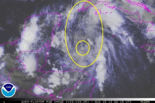
MGC wrote:Cloud tops are warming, shear to pick up tomorrow and land interaction.....92L is in for some hostile conditions tomorrow...we shall see if it is upgraded.....MGC


We knew cloud tops would warm during DMIN, right? Now we have to see what DMAX does. My problem is the stretching, which the GFS has forecast all along. If you watch the rgb sat loops (until you go blind; not recommended) you can see the overall circulation is getting stretched from north to south. There is an LLC developing now within that overall stretched circulation, but unless the two consolidate this will never get past TD or very weak TS.

Image
0 likes   

JonathanBelles
Professional-Met
Professional-Met
Posts: 11430
Age: 35
Joined: Sat Dec 24, 2005 9:00 pm
Location: School: Florida State University (Tallahassee, FL) Home: St. Petersburg, Florida
Contact:

#397 Postby JonathanBelles » Wed Aug 14, 2013 10:05 pm

0 likes   

User avatar
CaneCurious
Tropical Storm
Tropical Storm
Posts: 160
Joined: Wed Aug 25, 2004 1:40 pm
Location: Kenner, LA

Re: ATL: INVEST 92L - Discussion

#398 Postby CaneCurious » Wed Aug 14, 2013 10:06 pm

It's looking kinda sickly tonight. I'm not so sure it is going develop into more than it is right now. It's going to have to fight because today was the day to get its act together. The conditions were all there and it didn't do it.
0 likes   

User avatar
CaneCurious
Tropical Storm
Tropical Storm
Posts: 160
Joined: Wed Aug 25, 2004 1:40 pm
Location: Kenner, LA

#399 Postby CaneCurious » Wed Aug 14, 2013 10:09 pm

What time is the first Recon going out tomorrow?
0 likes   

User avatar
ROCK
Category 5
Category 5
Posts: 9484
Age: 54
Joined: Tue Aug 17, 2004 7:30 am
Location: Kemah, Texas

Re: ATL: INVEST 92L - Discussion

#400 Postby ROCK » Wed Aug 14, 2013 10:10 pm

talk about a non-stacked system.....ugh...it looks ugly...
0 likes   


Return to “2013”

Who is online

Users browsing this forum: No registered users and 2 guests