Thoughts on 2013 Atlantic Hurricane Season
Moderator: S2k Moderators
Forum rules

The posts in this forum are NOT official forecasts and should not be used as such. They are just the opinion of the poster and may or may not be backed by sound meteorological data. They are NOT endorsed by any professional institution or STORM2K. For official information, please refer to products from the National Hurricane Center and National Weather Service.

Re: Thoughts on activity as heart of season nears
I, too, hate preseason weather "predictions." Many people take them seriously, and when they don't pan out like this year, they say, "Well, none of those storms formed, so I'm not listening to the predictions any more!" Then, they don't prepare for next year's "predictions." 
0 likes
-
HURRICANELONNY
- Category 5

- Posts: 1392
- Joined: Wed May 07, 2003 6:48 am
- Location: HOLLYWOOD.FL
Re: Thoughts on activity as heart of season nears
Too many winers on here. After Nov. We can discuss who was closer in there predictions. Last year most predictions were for a normal to below normal. That didn't pan out to well. I guess mainly because El Nino and other factors. By the end of this season we can discuss the variables that made this season good or bad depending on how you view it. So lets wait till the game is played out. It's not even half time yet. 
0 likes
hurricanelonny
-
SFLcane

- S2K Supporter

- Posts: 10281
- Age: 48
- Joined: Sat Jun 05, 2010 1:44 pm
- Location: Lake Worth Florida
Re: Thoughts on activity as heart of season nears
80% of a typical Atlantic hurricane season falls between August 15th and October 15th.
Real season!
Real season!
0 likes
-
ninel conde
Re: Thoughts on activity as heart of season nears
TheStormExpert wrote:MetroMike wrote:Yes, welcome to the 2013 Atlantic "Invest Season" They will have to be some eventually its the earths way of transporting the heat out of the tropics.
I really don't even know why they call it hurricane season anymore. Shouldn't it be storm season?

dry air season from june01-nov30
0 likes
-
ninel conde
it seems pretty clear now with models showing nothing of importance that the preseason forecasts of high numbers and high landfalls wont verify.
when making a forecast next season i would wait till may 30th and look at 4 factors
a-el nino. if a strong one is occuring then go low.
b--tropical atlantic instability. if the 4 year trend hasnt budged then go low.
c-is the mid level dry air stronger than normal. if yes, go low.
d-is the east coast trof well established? if so forecast few landfalls. this season there have been times when a cane could have gotten close to the coast had they formed.
i think those are the most important factors.
0 likes
-
cycloneye

- Admin

- Posts: 149722
- Age: 69
- Joined: Thu Oct 10, 2002 10:54 am
- Location: San Juan, Puerto Rico
Re: Thoughts on activity as heart of season nears
Relevant tweet message by NHC director Knabb.
@NHCDirector 1m
In 2001, first Atlantic basin hurricane Sep 9. Totals for year: 9 hurricanes including 4 majors. Just sayin. http://ow.ly/21tMmw
@NHCDirector 1m
In 2001, first Atlantic basin hurricane Sep 9. Totals for year: 9 hurricanes including 4 majors. Just sayin. http://ow.ly/21tMmw
0 likes
Visit the Caribbean-Central America Weather Thread where you can find at first post web cams,radars
and observations from Caribbean basin members Click Here
and observations from Caribbean basin members Click Here

Re: Thoughts on activity as heart of season nears
cycloneye wrote:Relevant tweet message by NHC director Knabb.
@NHCDirector 1m
In 2001, first Atlantic basin hurricane Sep 9. Totals for year: 9 hurricanes including 4 majors. Just sayin. http://ow.ly/21tMmw
But then what happens if this doesn't happen? Nothing, people forget and then next season the number predictions come out and no one remembers how bad previous years were. It's time to stop with the pre-season numbers game outside of us amateurs because people really pay attention to those numbers. And when they don't verify, people become complacent.
0 likes
Personal Forecast Disclaimer:
The posts in this forum are NOT official forecast and should not be used as such. They are just the opinion of the poster and may or may not be backed by sound meteorological data. They are NOT endorsed by any professional institution or storm2k.org. For official information, please refer to the NHC and NWS products.
The posts in this forum are NOT official forecast and should not be used as such. They are just the opinion of the poster and may or may not be backed by sound meteorological data. They are NOT endorsed by any professional institution or storm2k.org. For official information, please refer to the NHC and NWS products.
I don't believe a busted seasonal forecast is related to complacency. Instead, I believe complacency is directly related to whether or not a particular locale has recently had its clock cleaned by tropical weather. In my area of Tampa bay the population has experienced decades of good luck. Naturally complacency is off the charts. that certainly wouldn't be an issue in Mississippi.
0 likes
-
beoumont

- Category 1

- Posts: 473
- Joined: Sun Jul 10, 2011 4:13 pm
- Location: East Central Florida
- Contact:
Re:
psyclone wrote:I don't believe a busted seasonal forecast is related to complacency. Instead, I believe complacency is directly related to whether or not a particular locale has recently had its clock cleaned by tropical weather. In my area of Tampa bay the population has experienced decades of good luck. Naturally complacency is off the charts. that certainly wouldn't be an issue in Mississippi.
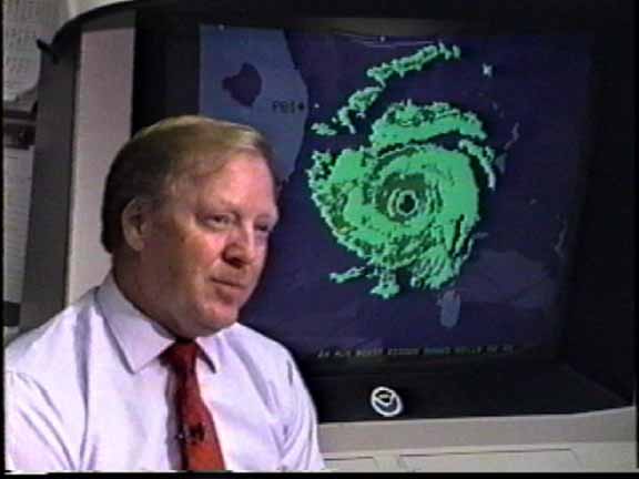
S. Florida, historically the most hurricane prone area of the USA, did not see a hurricane for a record 27 years, from 1965-1992. Andrew, an obvious Category 4-5 storm comes along, warnings were issued an adequate time in advance, yet something like only 15% of the residents even bothered to board up their windows. This instance is a prime example proving your point.
I shot the photo (video grab) below at the NHC showing Director Bob Sheets clearly warning TV audiences of the impending doom:
0 likes
List of 79 tropical cyclones intercepted by Richard Horodner:
http://www.canebeard.com/page/page/572246.htm
http://www.canebeard.com/page/page/572246.htm
-
hurricanetrack

- HurricaneTrack.com
- Posts: 1781
- Joined: Tue Dec 02, 2003 10:46 pm
- Location: Wilmington, NC
- Contact:
No one has yet to explain WHY the Atlantic is so stable. It's not SAL or dust. That is an entirely separate entity and is not the issue as of late. Don't believe me? See for yourself:
http://tropic.ssec.wisc.edu/real-time/s ... plitE&time
So I ask - why the stability? What is the cause of it. If anyone can explain that, I think we could all at least wrap our brains around it a little better.
http://tropic.ssec.wisc.edu/real-time/s ... plitE&time
So I ask - why the stability? What is the cause of it. If anyone can explain that, I think we could all at least wrap our brains around it a little better.
0 likes
-
SFLcane
- S2K Supporter
- Posts: 10281
- Age: 48
- Joined: Sat Jun 05, 2010 1:44 pm
- Location: Lake Worth Florida
Re:
hurricanetrack wrote:No one has yet to explain WHY the Atlantic is so stable. It's not SAL or dust. That is an entirely separate entity and is not the issue as of late. Don't believe me? See for yourself:
http://tropic.ssec.wisc.edu/real-time/s ... plitE&time
So I ask - why the stability? What is the cause of it. If anyone can explain that, I think we could all at least wrap our brains around it a little better.
The Atlantic has been dominated by an unusually active and strong TUTT so far this year --something that can not be predicted before a season begins. The series of unusually large upper-level lows has led to increased subsidence and drying, and also increased vertical wind shear -- all of which are detrimental to TC genesis and intensification. The 200 mb temps so far this year have been near or below normal, and that upper-level cooling has kept the THDV values from being even lower. So the atmosphere has been/is cooler and more unstable to dry ascent than in years past, but it is slightly more stable w.r.t to moist ascent. Once the low- to mid-levels moisten up, the atmosphere will quickly become quite unstable, which will support TC-genesis and intensification. However, it appears that those conditions may not arrive until September and October.
0 likes
-
tolakram
- Admin
- Posts: 20186
- Age: 62
- Joined: Sun Aug 27, 2006 8:23 pm
- Location: Florence, KY (name is Mark)
Re:
ninel conde wrote:it seems pretty clear now with models showing nothing of importance that the preseason forecasts of high numbers and high landfalls wont verify.
when making a forecast next season i would wait till may 30th and look at 4 factors
a-el nino. if a strong one is occuring then go low.
b--tropical atlantic instability. if the 4 year trend hasnt budged then go low.
c-is the mid level dry air stronger than normal. if yes, go low.
d-is the east coast trof well established? if so forecast few landfalls. this season there have been times when a cane could have gotten close to the coast had they formed.
i think those are the most important factors.
This all assumes that this season WILL be slow and that somehow you know better than the pro's that these are the key indicators. Do you really think the multiple agencies who forecast the season somehow missed these obvious indicators? They all updated their forecasts recently, and none abandoned the idea of an active season.
If tropical instability suddenly rises next week, then what? Why is it low, what will cause it to rise? Is it directly responsible for the lack of storms this year?
I can't answer any of those questions.
0 likes
M a r k
- - - - -
Join us in chat: Storm2K Chatroom Invite. Android and IOS apps also available.
The posts in this forum are NOT official forecasts and should not be used as such. Posts are NOT endorsed by any professional institution or STORM2K.org. For official information and forecasts, please refer to NHC and NWS products.
-
gatorcane

- S2K Supporter
- Posts: 23708
- Age: 48
- Joined: Sun Mar 13, 2005 3:54 pm
- Location: Boca Raton, FL
Re:
hurricanetrack wrote:No one has yet to explain WHY the Atlantic is so stable. It's not SAL or dust. That is an entirely separate entity and is not the issue as of late. Don't believe me? See for yourself:
http://tropic.ssec.wisc.edu/real-time/s ... plitE&time
So I ask - why the stability? What is the cause of it. If anyone can explain that, I think we could all at least wrap our brains around it a little better.
I think one of the issues that we have discussed in this forum is the overall lack of disturbances that can potentially form tropical cyclones out there right now and really for most of August so far. Take a look at the latest surface map which shows just two tropical waves across all of the Atlantic basin? Not what you would expect for late August:

0 likes
-
'CaneFreak

- Category 5
- Posts: 1487
- Joined: Mon Jun 05, 2006 10:50 am
- Location: New Bern, NC
Re: Re:
I think this is an excellent post and I agree. A++ May I also remind folks that November can still be an active month as well. I also agree with gatorcane above in regards to the overall lack of disturbances. Why the lack of disturbances? Well, the tropical waves have been dying before they can even get over water due to very hostile conditions overall in West Africa and the East Atlantic. It is not so much that there has been a lack of tropical waves coming off Africa as it is there has been an overall lack of tropical waves that have had favorable conditions in which to work with. Why the unfavorable conditions? Azores high has been too strong and too far south.
SFLcane wrote:The Atlantic has been dominated by an unusually active and strong TUTT so far this year --something that can not be predicted before a season begins. The series of unusually large upper-level lows has led to increased subsidence and drying, and also increased vertical wind shear -- all of which are detrimental to TC genesis and intensification. The 200 mb temps so far this year have been near or below normal, and that upper-level cooling has kept the THDV values from being even lower. So the atmosphere has been/is cooler and more unstable to dry ascent than in years past, but it is slightly more stable w.r.t to moist ascent. Once the low- to mid-levels moisten up, the atmosphere will quickly become quite unstable, which will support TC-genesis and intensification. However, it appears that those conditions may not arrive until September and October.
0 likes
-
SouthFloridian92
- Tropical Storm

- Posts: 120
- Age: 33
- Joined: Tue Dec 11, 2012 4:50 pm
- Location: Sebring, Florida
Re: Thoughts on activity as heart of season nears
Maybe an evil scientist is controlling the weather. Dun dun dun
0 likes

Re: Re:
beoumont wrote:psyclone wrote:I don't believe a busted seasonal forecast is related to complacency. Instead, I believe complacency is directly related to whether or not a particular locale has recently had its clock cleaned by tropical weather. In my area of Tampa bay the population has experienced decades of good luck. Naturally complacency is off the charts. that certainly wouldn't be an issue in Mississippi.
S. Florida, historically the most hurricane prone area of the USA, did not see a hurricane for a record 27 years, from 1965-1992. Andrew, an obvious Category 4-5 storm comes along, warnings were issued an adequate time in advance, yet something like only 15% of the residents even bothered to board up their windows. This instance is a prime example proving your point.
I shot the photo (video grab) below at the NHC showing Director Bob Sheets clearly warning TV audiences of the impending doom:
http://www.hurricanevideo.citymax.com/i ... sheets.jpg
warnings were issued LATE with Andrew... only about 18 hours lead time for hurricane force winds
0 likes
-
ninel conde
Re: Re:
tolakram wrote:ninel conde wrote:it seems pretty clear now with models showing nothing of importance that the preseason forecasts of high numbers and high landfalls wont verify.
when making a forecast next season i would wait till may 30th and look at 4 factors
a-el nino. if a strong one is occuring then go low.
b--tropical atlantic instability. if the 4 year trend hasnt budged then go low.
c-is the mid level dry air stronger than normal. if yes, go low.
d-is the east coast trof well established? if so forecast few landfalls. this season there have been times when a cane could have gotten close to the coast had they formed.
i think those are the most important factors.
This all assumes that this season WILL be slow and that somehow you know better than the pro's that these are the key indicators. Do you really think the multiple agencies who forecast the season somehow missed these obvious indicators? They all updated their forecasts recently, and none abandoned the idea of an active season.
If tropical instability suddenly rises next week, then what? Why is it low, what will cause it to rise? Is it directly responsible for the lack of storms this year?
I can't answer any of those questions.
if i had all the answers my pre-season forecast would have been perfect
2 things i will say. the tropical instability has been a multi-year pattern so i doubt it will change drastically in a week, though i hope it would. i also think the reason the big agencies barely lowered their numbers was for the sake of continuity. look at CSU's 2 week forecast for aug 16-29 just issued last week. they said it would be an above normal period and unless a strong storm forms in a hurry they arent even going to get that right.
0 likes
-
TheStormExpert
Re: Re:
SFLcane wrote:The Atlantic has been dominated by an unusually active and strong TUTT so far this year --something that can not be predicted before a season begins. The series of unusually large upper-level lows has led to increased subsidence and drying, and also increased vertical wind shear -- all of which are detrimental to TC genesis and intensification. The 200 mb temps so far this year have been near or below normal, and that upper-level cooling has kept the THDV values from being even lower. So the atmosphere has been/is cooler and more unstable to dry ascent than in years past, but it is slightly more stable w.r.t to moist ascent. Once the low- to mid-levels moisten up, the atmosphere will quickly become quite unstable, which will support TC-genesis and intensification. However, it appears that those conditions may not arrive until September and October.
I started browsing Storm2k back at the very beginning of the 2010 season before joking in early 2011. One thing I remember from the 2010 season was that a lot of people on here were mentioning that there was a persistent TUTT pattern that year too. And look at how many storms as well as big storms we ended up with.
0 likes
-
'CaneFreak
- Category 5
- Posts: 1487
- Joined: Mon Jun 05, 2006 10:50 am
- Location: New Bern, NC
Re: Re:
1. Tropical instability is not a pattern.
2. Do you have any sound data to back up this claim? Multiyear pattern over which time periods?
3. Things CAN, DO, and WILL change DRASTICALLY in short periods of time in the tropical Atlantic. They always have and they always will.
Models aren't perfect - even within a week. We still do not understand tropical cyclogenesis all that well and thus the reason that models don't perform that well with it. That's why we have projects like PREDICT. We also have a limited amount of good upper air data over the oceans and that will always be a problem when you are talking about a large body of water. Upper air data is critical to weather analysis and forecasting.
ninel conde wrote:the tropical instability has been a multi-year pattern so i doubt it will change drastically in a week, though i hope it would.
0 likes
-
ninel conde
Re: Re:
'CaneFreak wrote:1. Tropical instability is not a pattern.
2. Do you have any sound data to back up this claim? Multiyear pattern over which time periods?
3. Things CAN, DO, and WILL change DRASTICALLY in short periods of time in the tropical Atlantic. They always have and they always will.
Models aren't perfect - even within a week. We still do not understand tropical cyclogenesis all that well and thus the reason that models don't perform that well with it. That's why we have projects like PREDICT. We also have a limited amount of good upper air data over the oceans and that will always be a problem when you are talking about a large body of water. Upper air data is critical to weather analysis and forecasting.ninel conde wrote:the tropical instability has been a multi-year pattern so i doubt it will change drastically in a week, though i hope it would.
http://rammb.cira.colostate.edu/project ... tatins.gif
2011. very stable from about jul15- end of season
2010 again, except for 2 brief spikes very stable from aug-end of season
http://rammb.cira.colostate.edu/project ... tatins.gif
2012 was even more stable but i cant find the map
2013:
http://www.ssd.noaa.gov/PS/TROP/TCFP/da ... t_THDV.gif
here is an example of an unstable atlantic:
2003
http://rammb.cira.colostate.edu/project ... ns2003.gif
monumental difference from last few seasons
so yes, the tropical atlantic is in the midst of a multi year trend of stable conditions from 2010 to now.
0 likes
Who is online
Users browsing this forum: No registered users and 184 guests