
Upper Low Over FL Straits: 0% / 0%
Moderator: S2k Moderators
Forum rules

The posts in this forum are NOT official forecasts and should not be used as such. They are just the opinion of the poster and may or may not be backed by sound meteorological data. They are NOT endorsed by any professional institution or STORM2K. For official information, please refer to products from the National Hurricane Center and National Weather Service.
-
wxman57

- Moderator-Pro Met

- Posts: 23119
- Age: 68
- Joined: Sat Jun 21, 2003 8:06 pm
- Location: Houston, TX (southwest)
Re: Upper Low Over FL Straits
Wind shear certainly doesn't look that light if you look at a WV loop or the GFS projection of shear for 21Z today - 35-45 kts. Of course, right in the center of an upper level low the shear isn't going to be high.
0 likes
-
AJC3

- Admin

- Posts: 4152
- Age: 62
- Joined: Tue Aug 31, 2004 7:04 pm
- Location: Ballston Spa, New York
- Contact:
Re: Upper Low Over FL Straits
wxman57 wrote:Wind shear certainly doesn't look that light if you look at a WV loop or the GFS projection of shear for 21Z today - 35-45 kts. Of course, right in the center of an upper level low the shear isn't going to be high.
http://www.tropicaltidbits.com/analysis ... watl_4.png
And moreover, in BE (baroclincally enhanced) cases such as this, strong divergence which has been fueling the convection comes in tandem with relatively high shear, so you really can't have one without the other, to some degree.
More often than not (in my experience, anyway) it's not the ULL in and of itself that "drills down" to the surface, but the lowering of pressures on the divergent E-SE quads that lead to surface low development.
0 likes
-
otowntiger
- Category 5

- Posts: 1932
- Joined: Tue Aug 31, 2004 7:06 pm
Re:
Hurricane Alexis wrote:Sort of a surprise this blossomed.. Weather was expected to be dry today with low cloud cover.
well I don't know if I'd say this has "blossomed" by any means. Seems that since the pressures are high and NHC is saying just 10% seems like its only in the very very early bud stages. And a lot of buds have dried up and dropped off the tree way before they bloomed.
0 likes

Re: Upper Low Over FL Straits: 10% / 10%
Thanks for explaining Wxmn57....I
Learned something new today....
Learned something new today....
0 likes


-
tropicwatch

- Category 5
- Posts: 3426
- Age: 62
- Joined: Sat Jun 02, 2007 10:01 am
- Location: Panama City Florida
- Contact:
Usual afternoon pressure drops and convection is waning. Still bears watching over the next couple of days.
0 likes
Tropicwatch
Agnes 72', Eloise 75, Elena 85', Kate 85', Charley 86', Florence 88', Beryl 94', Dean 95', Erin 95', Opal 95', Earl 98', Georges 98', Ivan 2004', Arlene 2005', Dennis 2005', Ida 2009' Debby 2012' Irma 2017' Michael 2018'
Agnes 72', Eloise 75, Elena 85', Kate 85', Charley 86', Florence 88', Beryl 94', Dean 95', Erin 95', Opal 95', Earl 98', Georges 98', Ivan 2004', Arlene 2005', Dennis 2005', Ida 2009' Debby 2012' Irma 2017' Michael 2018'
-
Stormcenter
- S2K Supporter

- Posts: 6685
- Joined: Wed Sep 03, 2003 11:27 am
- Location: Houston, TX

-
Hurricane Alexis

- Category 2

- Posts: 683
- Age: 29
- Joined: Thu Jun 14, 2012 7:59 pm
- Location: Miami,Florida
Re: Re:
USTropics wrote:Stormcenter wrote:Where does the flow takes this the next few days?
Current steering pattern for a weak system is towards the west.
NHC has it drifting northward.
SURFACE PRESSURES ARE HIGH AND NO SIGNIFICANT DEVELOPMENT OF THIS
SYSTEM IS EXPECTED WHILE IT DRIFTS NORTHWARD FOR THE NEXT SEVERAL
DAYS.
0 likes
Personal Forecast Disclaimer:
The posts in this forum are NOT official forecast and should not be used as such. They are just the opinion of the poster and may or may not be backed by sound meteorological data. They are NOT endorsed by any professional institution or storm2k.org. For official information, please refer to the NHC and NWS products.
The posts in this forum are NOT official forecast and should not be used as such. They are just the opinion of the poster and may or may not be backed by sound meteorological data. They are NOT endorsed by any professional institution or storm2k.org. For official information, please refer to the NHC and NWS products.
Re: Upper Low Over FL Straits: 10% / 10%
yep the door is open to the north between the 2 highs....
0 likes

I'm late to this party but the radar presentation this morning was pretty startling off of the Middle Keys.
It seems this season that radar and satellite can be so deceiving. I think it was Dorian that looked like a million bucks but was worth about a dime.
It seems this season that radar and satellite can be so deceiving. I think it was Dorian that looked like a million bucks but was worth about a dime.
0 likes
Personal Forecast Disclaimer:
My posts are just my opinion and are most likely not backed by sound meteorological data. They are NOT endorsed by any professional institution or storm2k.org. For official information, please refer to the NHC and NWS products.
Bottom line is that I am just expressing my opinion!!!
My posts are just my opinion and are most likely not backed by sound meteorological data. They are NOT endorsed by any professional institution or storm2k.org. For official information, please refer to the NHC and NWS products.
Bottom line is that I am just expressing my opinion!!!
-
Aric Dunn
- Category 5
- Posts: 21238
- Age: 43
- Joined: Sun Sep 19, 2004 9:58 pm
- Location: Ready for the Chase.
- Contact:
Re:
fci wrote:I'm late to this party but the radar presentation this morning was pretty startling off of the Middle Keys.
It seems this season that radar and satellite can be so deceiving. I think it was Dorian that looked like a million bucks but was worth about a dime.
There is mid level circ anywhere from about 700mb and up. nothing at the surface and typically a surface low will form on the divergent ( as AJC3 also mentioned) side where the convection is able to form and maintain long enough. if that were to happen then the upper low pulls away or weakens then we might get something to watch. right now not likely the convection in these types of situations does not last long. however this time a year everything needs to be watched.
Close up view
http://www.ssd.noaa.gov/goes/east/wfo/eyw/mflash-rgb.html
0 likes
Note: If I make a post that is brief. Please refer back to previous posts for the analysis or reasoning. I do not re-write/qoute what my initial post said each time.
If there is nothing before... then just ask
Space & Atmospheric Physicist, Embry-Riddle Aeronautical University,
I believe the sky is falling...
If there is nothing before... then just ask
Space & Atmospheric Physicist, Embry-Riddle Aeronautical University,
I believe the sky is falling...
-
Aric Dunn
- Category 5
- Posts: 21238
- Age: 43
- Joined: Sun Sep 19, 2004 9:58 pm
- Location: Ready for the Chase.
- Contact:
IF you take a look at the RGB
http://www.ssd.noaa.gov/goes/east/wfo/eyw/mflash-rgb.html
you can clearly see the lower ( 700mb yellow) circ in the yellow then the milky white of the mid level (500mb red circle) then the obvious upper lvl ( 300+ mb black circle) low all rotation and not vertically stacked either. the lower lvl is the farthest and upper level farthest west.
0 likes
Note: If I make a post that is brief. Please refer back to previous posts for the analysis or reasoning. I do not re-write/qoute what my initial post said each time.
If there is nothing before... then just ask
Space & Atmospheric Physicist, Embry-Riddle Aeronautical University,
I believe the sky is falling...
If there is nothing before... then just ask
Space & Atmospheric Physicist, Embry-Riddle Aeronautical University,
I believe the sky is falling...
-
tropicwatch
- Category 5
- Posts: 3426
- Age: 62
- Joined: Sat Jun 02, 2007 10:01 am
- Location: Panama City Florida
- Contact:
Cool synopsis Aric, thanks.
0 likes
Tropicwatch
Agnes 72', Eloise 75, Elena 85', Kate 85', Charley 86', Florence 88', Beryl 94', Dean 95', Erin 95', Opal 95', Earl 98', Georges 98', Ivan 2004', Arlene 2005', Dennis 2005', Ida 2009' Debby 2012' Irma 2017' Michael 2018'
Agnes 72', Eloise 75, Elena 85', Kate 85', Charley 86', Florence 88', Beryl 94', Dean 95', Erin 95', Opal 95', Earl 98', Georges 98', Ivan 2004', Arlene 2005', Dennis 2005', Ida 2009' Debby 2012' Irma 2017' Michael 2018'
Re: Upper Low Over FL Straits: 10% / 10%
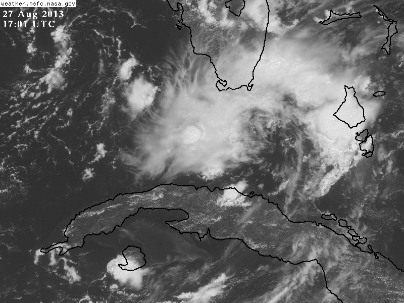
If it was going to drill down this is what you would want to see.
0 likes
-
cycloneye

- Admin
- Posts: 148726
- Age: 69
- Joined: Thu Oct 10, 2002 10:54 am
- Location: San Juan, Puerto Rico
Re: Upper Low Over FL Straits: 10% / 10%
No change in the %.
AN AREA OF CLOUDINESS AND A FEW THUNDERSTORMS NEAR THE SOUTHERN
FLORIDA PENINSULA IS ASSOCIATED WITH AN UPPER-LEVEL LOW AND A WEAK
SURFACE TROUGH. SURFACE PRESSURES ARE HIGH OVER THIS AREA...AND NO
SIGNIFICANT DEVELOPMENT OF THIS SYSTEM IS EXPECTED WHILE IT DRIFTS
NORTHWESTWARD FOR THE NEXT FEW DAYS. THIS SYSTEM HAS A LOW
CHANCE...10 PERCENT...OF BECOMING A TROPICAL CYCLONE DURING THE
NEXT 48 HOURS...AND A LOW CHANCE...10 PERCENT...OF BECOMING A
TROPICAL CYCLONE DURING THE NEXT 5 DAYS.
0 likes
Visit the Caribbean-Central America Weather Thread where you can find at first post web cams,radars
and observations from Caribbean basin members Click Here
and observations from Caribbean basin members Click Here
Re: Upper Low Over FL Straits: 10% / 10%
850 vort increasing
http://tropic.ssec.wisc.edu/real-time/w ... oom=&time=
all levels have vort now....wind shear is low all around it....convection firing right in the COC....to be honest it looks like it is trying to get to the surface.....
Key west radar...you tell me
http://radar.weather.gov/radar.php?prod ... X&loop=yes
Last edited by ROCK on Tue Aug 27, 2013 9:53 pm, edited 1 time in total.
0 likes
-
Hurricane Alexis
- Category 2
- Posts: 683
- Age: 29
- Joined: Thu Jun 14, 2012 7:59 pm
- Location: Miami,Florida
Re: Upper Low Over FL Straits: 10% / 10%
ROCK wrote:850 vort increasing
http://tropic.ssec.wisc.edu/real-time/w ... oom=&time=
all levels have vort now....wind shear is low all around it....convection firing right in the COC....to be honest it looks like it is trying to get to the surface.....
Yea, I've been monitoring it too. Let's see how it behaves during DMAX.
0 likes
Personal Forecast Disclaimer:
The posts in this forum are NOT official forecast and should not be used as such. They are just the opinion of the poster and may or may not be backed by sound meteorological data. They are NOT endorsed by any professional institution or storm2k.org. For official information, please refer to the NHC and NWS products.
The posts in this forum are NOT official forecast and should not be used as such. They are just the opinion of the poster and may or may not be backed by sound meteorological data. They are NOT endorsed by any professional institution or storm2k.org. For official information, please refer to the NHC and NWS products.
Who is online
Users browsing this forum: No registered users and 73 guests