FIM model continues to show development as it reaches the NE Caribbean.
http://fim.noaa.gov/FIM/displayMapLocal ... 44&adtfn=1
Tropical Wave in Central Atlantic (Is Invest 97L)
Moderator: S2k Moderators
Forum rules

The posts in this forum are NOT official forecasts and should not be used as such. They are just the opinion of the poster and may or may not be backed by sound meteorological data. They are NOT endorsed by any professional institution or STORM2K. For official information, please refer to products from the National Hurricane Center and National Weather Service.
-
HurricaneMaster_PR

- Category 2

- Posts: 795
- Joined: Tue Jul 22, 2003 6:23 pm
- Location: San Juan, Puerto Rico

Re:
Moving pretty quickly. Perhaps that maybe inhibiting development.Gustywind wrote:TROPICAL WEATHER DISCUSSION
NWS NATIONAL HURRICANE CENTER MIAMI FL
805 PM EDT TUE AUG 27 2013
TROPICAL WAVE W OF THE CAPE VERDE ISLANDS EXTENDS FROM 18N34W TO
A WEAK 1013 MB LOW NEAR 11N33W MOVING W NEAR 20 KT. WAVE IS
EMBEDDED WITHIN AN SURGE OF DEEP MOISTURE AS DEPICTED ON THE
TOTAL PRECIPITABLE WATER IMAGERY. SCATTERED MODERATE TO STRONG
CONVECTION IS W OF THE LOW FROM 8N-12N BETWEEN 35W-40W.
0 likes

-
cycloneye

- Admin

- Posts: 149492
- Age: 69
- Joined: Thu Oct 10, 2002 10:54 am
- Location: San Juan, Puerto Rico
Re: Re:
abajan wrote:Moving pretty quickly. Perhaps that maybe inhibiting development.Gustywind wrote:TROPICAL WEATHER DISCUSSION
NWS NATIONAL HURRICANE CENTER MIAMI FL
805 PM EDT TUE AUG 27 2013
TROPICAL WAVE W OF THE CAPE VERDE ISLANDS EXTENDS FROM 18N34W TO
A WEAK 1013 MB LOW NEAR 11N33W MOVING W [b]NEAR 20 KT. WAVE IS
EMBEDDED WITHIN AN SURGE OF DEEP MOISTURE AS DEPICTED ON THE
TOTAL PRECIPITABLE WATER IMAGERY. SCATTERED MODERATE TO STRONG
CONVECTION IS W OF THE LOW FROM 8N-12N BETWEEN 35W-40W.[/b]
Which means more west and that almost assures plenty of rain for the Eastern Caribbean islands unless it does like the Euro that goes NW missing the islands.
0 likes
Visit the Caribbean-Central America Weather Thread where you can find at first post web cams,radars
and observations from Caribbean basin members Click Here
and observations from Caribbean basin members Click Here
-
gatorcane

- S2K Supporter

- Posts: 23708
- Age: 48
- Joined: Sun Mar 13, 2005 3:54 pm
- Location: Boca Raton, FL
Re: Re:
Gustywind wrote:gatorcane wrote:Gustywind wrote:Hey Cycloneye, could we have the latest pic related to Pouch 25L to have a better idea of this feature? Thanks
Here is another look. Convection looking better this morning:
Thanks Gatorcane, that's a very nice one too. We have a better idea of Pouch 25L. Agree that convection is in better shape, if this trend continues during the next 24h, do you think that we could have an Invest from that before Friday? What are your thoughts?
Hi Gustywind, I think we have an invest before Friday and this system is "a go" for development. Leewards should be paying attention.
The posts in this forum are NOT official forecast and should not be used as such. They are just the opinion of the poster and may or may not be backed by sound meteorological data. They are NOT endorsed by any professional institution or storm2k.org. For official information, please refer to the NHC and NWS products
0 likes
-
Gustywind

- Category 5

- Posts: 12334
- Joined: Mon Sep 03, 2007 7:29 am
- Location: Baie-Mahault, GUADELOUPE
Re: Re:
abajan wrote:Moving pretty quickly. Perhaps that maybe inhibiting development.Gustywind wrote:TROPICAL WEATHER DISCUSSION
NWS NATIONAL HURRICANE CENTER MIAMI FL
805 PM EDT TUE AUG 27 2013
TROPICAL WAVE W OF THE CAPE VERDE ISLANDS EXTENDS FROM 18N34W TO
A WEAK 1013 MB LOW NEAR 11N33W MOVING W NEAR 20 KT. WAVE IS
EMBEDDED WITHIN AN SURGE OF DEEP MOISTURE AS DEPICTED ON THE
TOTAL PRECIPITABLE WATER IMAGERY. SCATTERED MODERATE TO STRONG
CONVECTION IS W OF THE LOW FROM 8N-12N BETWEEN 35W-40W.
Perhaps, we will see, but that's a very nice observation Abajan:) . Whereas, compared to TS Chantal, 25L is not racing
0 likes
-
Gustywind
- Category 5
- Posts: 12334
- Joined: Mon Sep 03, 2007 7:29 am
- Location: Baie-Mahault, GUADELOUPE
Re: Re:
cycloneye wrote:abajan wrote:Moving pretty quickly. Perhaps that maybe inhibiting development.Gustywind wrote:TROPICAL WEATHER DISCUSSION
NWS NATIONAL HURRICANE CENTER MIAMI FL
805 PM EDT TUE AUG 27 2013
TROPICAL WAVE W OF THE CAPE VERDE ISLANDS EXTENDS FROM 18N34W TO
A WEAK 1013 MB LOW NEAR 11N33W MOVING W [b]NEAR 20 KT. WAVE IS
EMBEDDED WITHIN AN SURGE OF DEEP MOISTURE AS DEPICTED ON THE
TOTAL PRECIPITABLE WATER IMAGERY. SCATTERED MODERATE TO STRONG
CONVECTION IS W OF THE LOW FROM 8N-12N BETWEEN 35W-40W.[/b]
Which means more west and that almost assures plenty of rain for the Eastern Caribbean islands unless it does like the Euro that goes NW missing the islands.
Good point, nice analysis Cycloneye
Hopefully, we're far away from that
0 likes
-
HurricaneDREW92
- Category 1

- Posts: 320
- Age: 27
- Joined: Sun Jul 28, 2013 11:56 am
- Location: Boston, MA
Re: Tropical Wave in East Atlantic (Pouch 25L) 0% / 30%
I feel slightly more confident this may become an EC or NE GOM storm. Also, cycloneye could you post a GIF of our TWAVE. Thank you 
0 likes
This post is NOT AN OFFICIAL FORECAST and should not be used as such. It is just the opinion of the poster and may or may not be backed by sound meteorological data. It is NOT endorsed by any professional institution including storm2k.org. For Official Information please refer to the NHC and NWS products.
-THE ABOVE IS THE OPINION OF DREW ONLY
-THE ABOVE IS THE OPINION OF DREW ONLY
-
ozonepete
- Professional-Met

- Posts: 4743
- Joined: Mon Sep 07, 2009 3:23 pm
- Location: From Ozone Park, NYC / Now in Brooklyn, NY
Re: Re:
ninel conde wrote:Alyono wrote:one issue may be that the greatest vorticity may be well north of the convection. This may be why the models are only indicating slow and limited development with the system.
It's a disorganized mess right now and even if it becomes a TC, chances are it will remain a disorganized mess
i pointed that out a few days ago when i observed that the part of the wave that might develop was devoid of clouds at the time. the part of the wave thats going to develop, if it does, is up at 16.5-17n.
That part of the wave may not develop at all. It is completely up in the air what part of the wave develops - the part that develops depends on where the most vorticity and instability is. Since the vorticity appears to be dropping southward below 15N towards where the strongest convection now appears to be developing it is very possible that the center could form below 15 degrees. Remember that an MLC is the first stage of development in most cases, especially for Cape Verde systems, and the MLC forms where the heaviest convection clusters. Any nearby vorticity can fizzle pretty quickly when the main thunderstorm cluster starts organizing around its own center.
0 likes
-
floridasun78
- Category 5
- Posts: 3755
- Joined: Sun May 17, 2009 10:16 pm
- Location: miami fl
-
ozonepete
- Professional-Met
- Posts: 4743
- Joined: Mon Sep 07, 2009 3:23 pm
- Location: From Ozone Park, NYC / Now in Brooklyn, NY
Re: Re:
Gustywind wrote:cycloneye wrote:
Which means more west and that almost assures plenty of rain for the Eastern Caribbean islands unless it does like the Euro that goes NW missing the islands.
Good point, nice analysis Cycloneye. And should i add that in Guadeloupe, Martinica... Monday teachers back to school after 2 months in holidays as the pupils (Tuesday). That could pose some serious troubles on the roads, etc. if measures are not quickly anticipated.
Hopefully, we're far away from that
I definitely would watch, Gusty. Looks to be developing further south. And looks pretty healthy and growing fast.
0 likes
-
cycloneye
- Admin
- Posts: 149492
- Age: 69
- Joined: Thu Oct 10, 2002 10:54 am
- Location: San Juan, Puerto Rico
Re:
gatorcane wrote:Latest. Looking really good from a moisture/convection perspective:
http://i1276.photobucket.com/albums/y47 ... 138ea5.jpg
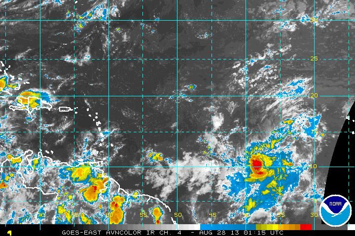
Is a matter of time that is tagged as Invest 96L.
0 likes
Visit the Caribbean-Central America Weather Thread where you can find at first post web cams,radars
and observations from Caribbean basin members Click Here
and observations from Caribbean basin members Click Here
-
Gustywind
- Category 5
- Posts: 12334
- Joined: Mon Sep 03, 2007 7:29 am
- Location: Baie-Mahault, GUADELOUPE
Re: Re:
ozonepete wrote:ninel conde wrote:Alyono wrote:one issue may be that the greatest vorticity may be well north of the convection. This may be why the models are only indicating slow and limited development with the system.
It's a disorganized mess right now and even if it becomes a TC, chances are it will remain a disorganized mess
i pointed that out a few days ago when i observed that the part of the wave that might develop was devoid of clouds at the time. the part of the wave thats going to develop, if it does, is up at 16.5-17n.
That part of the wave may not develop at all. It is completely up in the air what part of the wave develops - the part that develops depends on where the most vorticity and instability is. Since the vorticity appears to be dropping southward below 15N towards where the strongest convection now appears to be developing it is very possible that the center could form below 15 degrees. Remember that an MLC is the first stage of development in most cases, especially for Cape Verde systems, and the MLC forms where the heaviest convection clusters. Any nearby vorticity can fizzle pretty quickly when the main thunderstorm cluster starts organizing around its own center.
Glad to see you back on this topic Ozonepete
0 likes

Re: Tropical Wave in East Atlantic (Pouch 25L) 0% / 30%
https://www.fnmoc.navy.mil/wxmap_cgi/cg ... t=Tropical
NAVGEM sends this south of PR and heading into Jam.....lots of isobars
NAVGEM sends this south of PR and heading into Jam.....lots of isobars
0 likes
-
ninel conde
Re: Re:
ozonepete wrote:ninel conde wrote:Alyono wrote:one issue may be that the greatest vorticity may be well north of the convection. This may be why the models are only indicating slow and limited development with the system.
It's a disorganized mess right now and even if it becomes a TC, chances are it will remain a disorganized mess
i pointed that out a few days ago when i observed that the part of the wave that might develop was devoid of clouds at the time. the part of the wave thats going to develop, if it does, is up at 16.5-17n.
That part of the wave may not develop at all. It is completely up in the air what part of the wave develops - the part that develops depends on where the most vorticity and instability is. Since the vorticity appears to be dropping southward below 15N towards where the strongest convection now appears to be developing it is very possible that the center could form below 15 degrees. Remember that an MLC is the first stage of development in most cases, especially for Cape Verde systems, and the MLC forms where the heaviest convection clusters. Any nearby vorticity can fizzle pretty quickly when the main thunderstorm cluster starts organizing around its own center.
thanks for the explanation. thats probably why joe bastardi says its headed for the windwards.
Last edited by ninel conde on Tue Aug 27, 2013 9:18 pm, edited 1 time in total.
0 likes
-
Gustywind
- Category 5
- Posts: 12334
- Joined: Mon Sep 03, 2007 7:29 am
- Location: Baie-Mahault, GUADELOUPE
Re:
gatorcane wrote:Latest saved image. No shading from NHC at 8pm EST outlook? Interesting...
http://i1276.photobucket.com/albums/y47 ... 138ea5.jpg
Nice looking TWAVE. Convection is expanding nicely, continues to becoming fatter and fatter.
The posts in this forum are NOT official forecast and should not be used as such. They are just the opinion of the poster and may or may not be backed by sound meteorological data. They are NOT endorsed by any professional institution or storm2k.org. For official information, please refer to the NHC and NWS products
0 likes
-
ninel conde
Re: Tropical Wave in East Atlantic (Pouch 25L) 0% / 30%
ROCK wrote:https://www.fnmoc.navy.mil/wxmap_cgi/cgi-bin/wxmap_loop.cgi?&area=nvg_troplant&prod=z85&dtg=2013082718&set=Tropical
NAVGEM sends this south of PR and heading into Jam.....lots of isobars
not to be a nitpicker, but isnt this model developing the small cluster of storms at about 12n 53w and not the wave in question here? the one not quite at 40w?
0 likes
Who is online
Users browsing this forum: No registered users and 196 guests